NaviSys Technology - Your Location Partner User’s Manual - GR-312
iv
Contents
1
INTRODUCTION ........................................................................................................................................ 1
1.1
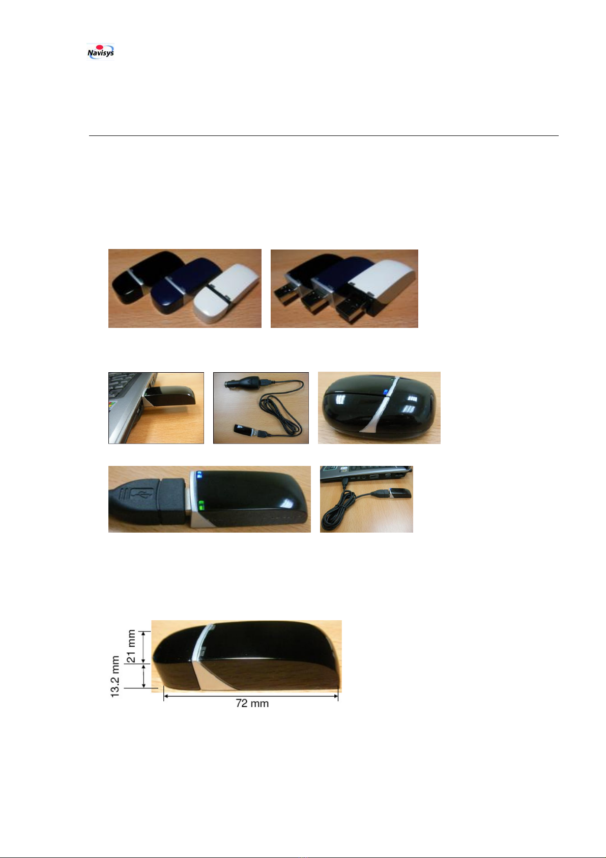
A
PPLICATIONS
.............................................................................................................................. 1
1.2
O
UTLOOK
..................................................................................................................................... 1
1.3
M
AIN
F
EATURES
........................................................................................................................... 2
1.4
S
PECIFICATIONS
............................................................................................................................ 3
1.5
E
LECTRICAL AND
E
NVIRONMENTAL
D
ATA
.................................................................................... 4
1.6
LED
D
ISPLAY
............................................................................................................................... 5
1.7
C
OMMUNICATION
C
ONNECTIONS
................................................................................................. 5
1.8
B
UNDLED
T
OOLS
.......................................................................................................................... 5
1.9
C
ERTIFICATIONS
........................................................................................................................... 7
1.10
R
ELATED
D
OCUMENTS
................................................................................................................. 7
2
GETTING STARTED .................................................................................................................................. 8
2.1
B
LUETOOTH
C
ONNECTION
E
STABLISHMENT
................................................................................ 8
2.2
USB
C
ONNECTION
E
STABLISHMENT
.......................................................................................... 11
2.3
V
IEWING
V
ISITED
P
ATH FROM
G
OOGLE
E
ARTH
.......................................................................... 12
2.4
T
RACK
B
ROWSING IN
G
OOGLE
E
ARTH
....................................................................................... 12
2.5
P
HOTO
T
AGGING
......................................................................................................................... 15
3
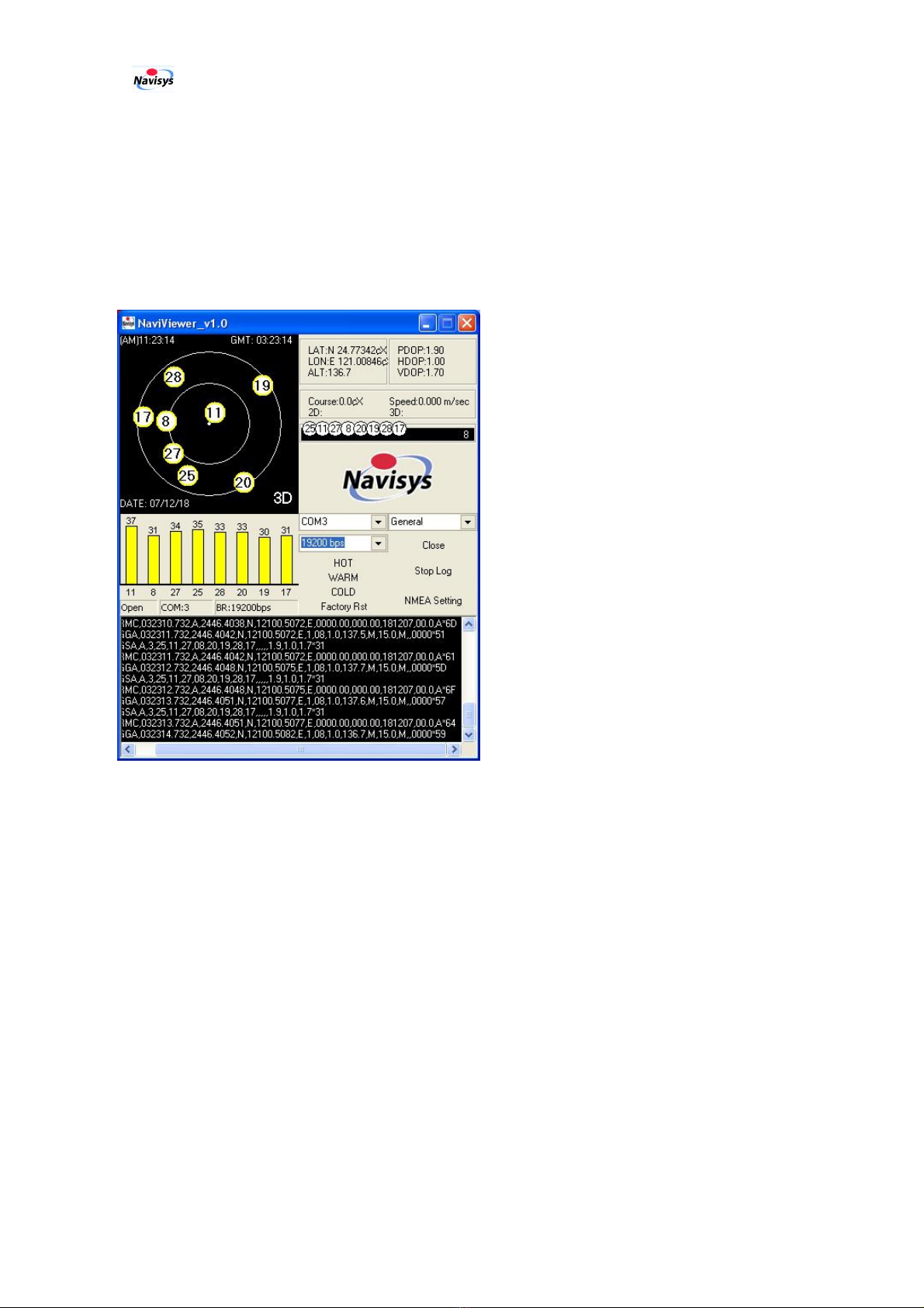
SOFTWARE INTERFACE........................................................................................................................ 17
3.1
NMEA
O
UTPUT
M
ESSAGES
........................................................................................................ 17
3.2
GPGGA
-
G
LOBAL
P
OSITIONING
S
YSTEM
F
IX
D
ATA
.................................................................. 18
3.3
GPGLL
-
G
EOGRAPHIC
P
OSITION
-
L
ATITUDE
/
L
ONGITUDE
...................................................... 18
3.4
GPGSA
-
GNSS
DOP
AND
A
CTIVE
S
ATELLITES
......................................................................... 19
3.5
GPGSV
-
GNSS
S
ATELLITES IN
V
IEW
........................................................................................ 19
3.6
GPRMC
-
R
ECOMMENDED
M
INIMUM
S
PECIFIC
GNSS
D
ATA
..................................................... 20
3.7
GPVTG
-
C
OURSE
O
VER
G
ROUND AND
G
ROUND
S
PEED
........................................................... 20
3.8
GPZDA
-
S
I
RF
T
IMING
M
ESSAGE
.............................................................................................. 21
4
TROUBLE SHOOTING ............................................................................................................................ 22
5
FCC SAFETY STATEMENT .................................................................................................................... 23
6
WARRANTY............................................................................................................................................... 24
7
ORDERING INFORMATION .................................................................................................................. 25