Bdale Garbee and Keith Packard TELEGPS User manual

TeleGPS Owner’s Manual
An Owner's Manual for the
TeleGPS recording GPS tracker
Bdale Garbee
Keith Packard

TeleGPS Owner’s Manual: An Owner's Manual for the TeleGPS recording
GPS tracker
Bdale Garbee
Keith Packard
Copyright © 2015 Bdale Garbee and Keith Packard
This document is released under the terms of the Creative Commons ShareAlike 3.0 license.
Revision History
Revision 1.6.1 15 July 2015
Minor release adding TeleBT v3.0 support.
Revision 1.6 8 January 2015
Major release adding TeleDongle v3.0 support.
Revision 1.5 6 September 2014
Major release adding EasyMega support.
Revision 1.4.2 17 August 2014
Minor release fixing some Windows installation bugs.
Revision 1.4.1 20 June 2014
Minor release fixing some installation bugs.
Revision 1.4 15 June 2014
Initial version

This document is released under the terms of the Creative Commons ShareAlike 3.0 license. i
Acknowledgments
Thanks to Anthony (A J) Towns for major contributions including the TeleGPS graphing and site map
code and associated documentation. Free software means that our customers and friends can become
our collaborators, and we certainly appreciate this level of contribution!
Have fun using these products, and we hope to meet all of you out on the rocket flight line somewhere.
Bdale Garbee, KB0G
NAR #87103, TRA #12201
Keith Packard, KD7SQG
NAR #88757, TRA #12200

This document is released under the terms of the Creative Commons ShareAlike 3.0 license. ii
Table of Contents
1. TeleGPS Quick Start Guide ..................................................................................................................... 1
2. Using TeleGPS Hardware ........................................................................................................................ 2
2.1. Hooking Up Lithium Polymer Batteries ....................................................................................... 2
2.2. On-board Data Recording ............................................................................................................ 2
2.3. Installation .................................................................................................................................... 2
3. TeleGPS Application ................................................................................................................................ 4
3.1. Telemetry Monitoring ................................................................................................................... 4
3.1.1. Map .................................................................................................................................... 4
3.1.2. Location ............................................................................................................................. 5
3.1.3. Status ................................................................................................................................. 6
3.1.4. Table ................................................................................................................................... 7
3.2. TeleGPS Menus ............................................................................................................................ 8
3.2.1. New Window ...................................................................................................................... 8
3.3. Graph Data ................................................................................................................................... 9
3.3.1. Data Graph ........................................................................................................................ 9
3.3.2. Graph Configuration ....................................................................................................... 10
3.3.3. Statistics ........................................................................................................................... 11
3.3.4. Map .................................................................................................................................. 12
3.4. Export Data ................................................................................................................................ 12
3.4.1. Comma Separated Value Format ................................................................................... 12
3.4.2. Keyhole Markup Language (for Google Earth) ............................................................... 13
3.5. Load Maps .................................................................................................................................. 13
3.6. Preferences ................................................................................................................................. 14
3.6.1. Voice Settings .................................................................................................................. 14
3.6.2. Log Directory ................................................................................................................... 14
3.6.3. Callsign ............................................................................................................................. 15
3.6.4. Imperial Units .................................................................................................................. 15
3.6.5. Serial Debug .................................................................................................................... 15
3.6.6. Font size .......................................................................................................................... 15
3.6.7. Look & feel ...................................................................................................................... 15
3.6.8. Menu position ................................................................................................................. 15
3.6.9. Map Cache Size ............................................................................................................... 15
3.6.10. Manage Frequencies ..................................................................................................... 15
3.7. Close ........................................................................................................................................... 16
3.8. Exit .............................................................................................................................................. 16
3.9. Connect Device .......................................................................................................................... 16
3.10. Disconnect ................................................................................................................................ 16
3.11. Scan Channels .......................................................................................................................... 16
3.12. Download Data ......................................................................................................................... 16
3.13. Configure Device ...................................................................................................................... 17
3.13.1. Frequency ...................................................................................................................... 18
3.13.2. RF Calibration ................................................................................................................ 18
3.13.3. Telemetry/RDF/APRS Enable ......................................................................................... 18
3.13.4. Telemetry baud rate ...................................................................................................... 18
3.13.5. APRS Interval ................................................................................................................. 18
3.13.6. APRS SSID ...................................................................................................................... 18
3.13.7. APRS Format ................................................................................................................. 18
3.13.8. Callsign ........................................................................................................................... 18

TeleGPS Owner’s Manual
This document is released under the terms of the Creative Commons ShareAlike 3.0 license. iii
3.13.9. Logging Trigger Motion ................................................................................................. 19
3.13.10. Position Reporting Interval ......................................................................................... 19
3.14. Flash Device ............................................................................................................................. 19
A. TeleGPS System Operation ................................................................................................................... 20
A.1. GFSK Telemetry .......................................................................................................................... 20
A.2. APRS ........................................................................................................................................... 20
A.3. Configurable Parameters ........................................................................................................... 21
B. Handling Precautions ............................................................................................................................ 22
C. Technical Information ........................................................................................................................... 23
C.1. GPS Receiver .............................................................................................................................. 23
C.2. Micro-controller .......................................................................................................................... 23
C.3. Lithium Polymer Battery ............................................................................................................ 23
C.4. Mechanical Considerations ........................................................................................................ 23
C.5. On-board data storage .............................................................................................................. 23
D. Updating Device Firmware ................................................................................................................... 24
D.1. Updating TeleGPS Firmware ...................................................................................................... 24
E. Release Notes ....................................................................................................................................... 25
E.1. Release Notes for Version 1.6.2 ................................................................................................ 25
E.1.1. AltOS ................................................................................................................................ 25
E.1.2. AltosUI and TeleGPS Applications ................................................................................... 25
E.1.3. Documentation ................................................................................................................ 25
E.2. Release Notes for Version 1.6.1 ................................................................................................ 26
E.2.1. AltOS ................................................................................................................................ 26
E.2.2. AltosUI and TeleGPS Applications ................................................................................... 26
E.2.3. AltosDroid ........................................................................................................................ 27
E.3. Release Notes for Version 1.6 ................................................................................................... 28
E.3.1. AltOS ................................................................................................................................ 28
E.3.2. AltosUI and TeleGPS Applications ................................................................................... 28
E.4. Release Notes for Version 1.5 ................................................................................................... 30
E.4.1. AltOS ................................................................................................................................ 30
E.4.2. AltosUI and TeleGPS Applications ................................................................................... 30
E.5. Release Notes for Version 1.4.2 ................................................................................................ 32
E.5.1. AltosUI and TeleGPS Applications ................................................................................... 32
E.6. Release Notes for Version 1.4.1 ................................................................................................ 33
E.6.1. AltosUI and TeleGPS Applications: .................................................................................. 33
E.7. Release Notes for Version 1.4 ................................................................................................... 34
E.7.1. AltOS ................................................................................................................................ 34
E.7.2. AltosUI Application .......................................................................................................... 34
E.7.3. TeleGPS Application ........................................................................................................ 35
E.7.4. Documentation ................................................................................................................ 35

This document is released under the terms of the Creative Commons ShareAlike 3.0 license. iv
List of Figures
3.1. TeleGPS Map View ................................................................................................................................ 5
3.2. TeleGPS Location View ......................................................................................................................... 6
3.3. TeleGPS Status View ............................................................................................................................. 7
3.4. TeleGPS Information Table ................................................................................................................... 8
3.5. TeleGPS Graph ..................................................................................................................................... 9
3.6. TeleGPS Graph Configuration ............................................................................................................ 10
3.7. TeleGPS Statistics ............................................................................................................................... 11
3.8. TeleGPS Map ...................................................................................................................................... 12
3.9. Load Maps Window ........................................................................................................................... 13
3.10. TeleGPS Preferences Window .......................................................................................................... 14
3.11. Device Selection Dialog .................................................................................................................... 16
3.12. Radio Scanning Dialog ..................................................................................................................... 16
3.13. TeleGPS Configuration Dialog .......................................................................................................... 17

This document is released under the terms of the Creative Commons ShareAlike 3.0 license. v
List of Tables
A.1. Altus Metrum APRS Comments ......................................................................................................... 20

This document is released under the terms of the Creative Commons ShareAlike 3.0 license. 1
Chapter1.TeleGPS Quick Start Guide
TeleGPS is designed to be easy to use. Requiring no external components, flying takes just a few steps.
1. First, download and install the software from http://altusmetrum.org/AltOS. This will make sure that
you have the right device drivers installed.
2. Next, plug in the battery and USB cable and connect TeleGPS to your computer. This will charge the
battery and allow you to configure the device.
3. Start the TeleGPS application and set the callsign and frequency on your TeleGPS device; refer to
Section3.13, “Configure Device” for instructions.
4. Unplug TeleGPS when the battery charger light goes green. This will enable the radio and logging
portions of the TeleGPS firmware.
5. Connect TeleDongle to your computer and start TeleGPS or start AltosDroid on your android
device and connect to TeleBT. Set the frequency to match the TeleGPS and you should be receiving
telemetry.

This document is released under the terms of the Creative Commons ShareAlike 3.0 license. 2
Chapter2.Using TeleGPS Hardware
2.1.Hooking Up Lithium Polymer Batteries
TeleGPS has a two pin JST PH series connector to connect up a single-cell Lithium Polymer cell (3.7V
nominal). You can purchase matching batteries from the Altus Metrum store, or other vendors, or you
can make your own. Pin 1 of the connector is positive, pin 2 is negative. Spark Fun sells a cable with the
connector attached, which they call a JST Jumper 2 Wire Assembly
Warning
Many RC vendors also sell lithium polymer batteries with this same connector. All that we have
found use the opposite polarity, and if you use them that way, you will damage or destroy
TeleGPS.
2.2.On-board Data Recording
TeleGPS logs GPS data at a user-configurable rate. Data are logged to a 2MB on-board flash memory
part, which can be partitioned into several equal-sized blocks, one for each flight. 64kB of this storage
are reserved to hold configuration data, leaving 1984kB for flight data.
The on-board flash is partitioned into separate flight logs, each of a fixed maximum size. Increase the
maximum size of each log and you reduce the number of flights that can be stored. Decrease the size
and you can store more flights.
To compute the amount of space needed for a single log, you can divide the expected time (in seconds)
by the sample period (by default, 1 second per sample) and then multiply the result by 32 bytes per
sample. For instance, a sample period of 1 second and a flight lasting one hour will take 32 * 3600 =
115200 bytes. TeleGPS does try to reduce log space used by not recording position information when it
isn’t moving, so actual space consumed may be less than this.
The default size allows for four flights of 496kB each, which provides over four hours of logging at 1
sample per second.
TeleGPS will not overwrite existing flight data, so be sure to download flight data and erase it from the
onboard flash before it fills up. TeleGPS will still report telemetry even if memory is full, so the only thing
you will lose is the on-board data log.
2.3.Installation
The battery connectors are a standard 2-pin JST connector and match batteries sold by Spark Fun.
These batteries are single-cell Lithium Polymer batteries that nominally provide 3.7 volts. Other
vendors sell similar batteries for RC aircraft using mating connectors, however the polarity for those
is generally reversed from the batteries used by Altus Metrum products. In particular, the Tenergy
batteries supplied for use in Featherweight flight computers are not compatible with Altus Metrum
flight computers or battery chargers.
Warning
Check polarity and voltage before connecting any battery not purchased from Altus Metrum or
Spark Fun.

Using TeleGPS Hardware
This document is released under the terms of the Creative Commons ShareAlike 3.0 license. 3
TeleGPS uses an integrate GPS patch antenna and won’t receive GPS signals if installed inside a
metal or carbon fiber compartment. Test GPS reception and telemetry transmission with the system
installed and all other electronics powered up to verify signal reception and make sure there isn’t any
interference from other systems.

This document is released under the terms of the Creative Commons ShareAlike 3.0 license. 4
Chapter3.TeleGPS Application
The TeleGPS application provides a graphical user interface for interacting with the Altus Metrum
product family. TeleGPS can monitor telemetry data, configure devices and many other tasks. The
primary interface window is for displaying data received over the telemetry link. There are additional
tasks available from the main window menu bar.
3.1.Telemetry Monitoring
This is the window brought up when you start the application. If you have a TeleDongle device
connected to the computer, it will automatically be selected for telemetry monitoring
All telemetry data received are automatically recorded in suitable log files. The name of the files
includes the current date and TeleGPS serial and flight numbers.
The radio frequency being monitored by the TeleDongle device is displayed at the top of the window.
You can configure the frequency by clicking on the frequency box and selecting the desired frequency.
The TeleGPS application remembers the last frequency selected for each TeleDongle and selects that
automatically the next time you use that device.
Below the TeleDongle frequency selector, the window contains a few significant pieces of information
about the altimeter providing the telemetry data stream:
• The configured call-sign
• The device serial number
• The flight number. TeleGPS remembers how many times it has flown.
• The Received Signal Strength Indicator value. This lets you know how strong a signal TeleDongle is
receiving. The radio inside TeleDongle operates down to about -100dBm; weaker signals may not be
receivable. The packet link uses error detection and correction techniques which prevent incorrect
data from being reported.
• The age of the displayed data, in seconds since the last successfully received telemetry packet. In
normal operation this will stay in the low single digits. If the number starts counting up, then you are
no longer receiving data over the radio link from the flight computer.
Finally, the largest portion of the window contains a set of tabs, each of which contain some information
about the TeleGPS board. The final table tab displays many of the raw telemetry values in one place in a
spreadsheet-like format.
3.1.1.Map
The Map tab shows the TeleGPS track over time on top of map data making it easy to locate the device.

TeleGPS Application
This document is released under the terms of the Creative Commons ShareAlike 3.0 license. 5
Figure3.1.TeleGPS Map View
The map’s default scale is approximately 3m (10ft) per pixel. The map can be dragged using the left
mouse button. The map will attempt to keep the rocket roughly centered while data is being received.
You can adjust the style of map and the zoom level with buttons on the right side of the map window.
You can draw a line on the map by moving the mouse over the map with a button other than the left
one pressed, or by pressing the left button while also holding down the shift key. The length of the line
in real-world units will be shown at the start of the line.
Images are fetched automatically via the Google Maps Static API, and cached on disk for reuse. If map
images cannot be downloaded, the rocket’s path will be traced on a dark gray background instead.
You can pre-load images for your favorite launch sites before you leave home; check out Section3.5,
“Load Maps”.
3.1.2.Location
The Location tab shows the raw GPS data received from TeleGPS.

TeleGPS Application
This document is released under the terms of the Creative Commons ShareAlike 3.0 license. 6
Figure3.2.TeleGPS Location View
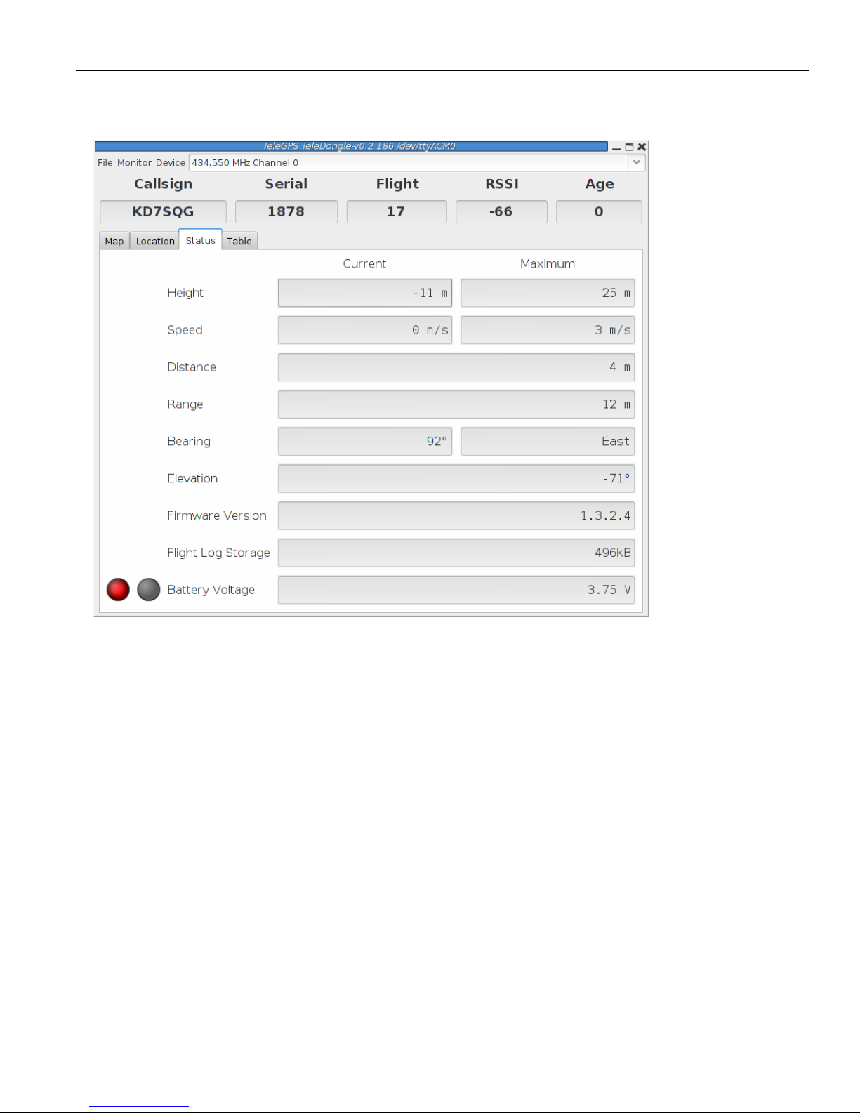
3.1.3.Status
The Status tab shows data relative to the location of TeleGPS when the application first received
telemetry from it.
TeleGPS Application
This document is released under the terms of the Creative Commons ShareAlike 3.0 license. 7
Figure3.3.TeleGPS Status View
3.1.4.Table
The Table tab shows detailed information about the GPS receiver

TeleGPS Application
This document is released under the terms of the Creative Commons ShareAlike 3.0 license. 8
Figure3.4.TeleGPS Information Table
3.2.TeleGPS Menus
TeleGPS has three or four menus at the top of the window:
File
New Window, Graph Data, Export Data, Load Maps, Preferences, Close and Exit
Monitor
Connect Device, Disconnect and Scan Channels
Device
Download Data, Configure Device and Flash Device
Frequency
This shows the current monitoring frequency with a drop-down menu listing other configured
frequencies. You can change the set of frequencies shown here from the Preferences dialog. This
menu is only shown when the TeleGPS application is connected to a TeleDongle or TeleBT device.
3.2.1.New Window
This creates another telemetry monitoring window, in case you have multiple TeleDongle devices
connected to the computer.

TeleGPS Application
This document is released under the terms of the Creative Commons ShareAlike 3.0 license. 9
3.3.Graph Data
The Graph tab shows a plot of the the GPS data collected. The X axis is time in seconds; there are a
variety of Y axes available for different kinds of data. This window also allows you to see some statistics
computed from the data, and an overall map of the entire data record.
3.3.1.Data Graph
Figure3.5.TeleGPS Graph

TeleGPS Application
This document is released under the terms of the Creative Commons ShareAlike 3.0 license. 10
3.3.2.Graph Configuration
Figure3.6.TeleGPS Graph Configuration
This selects which graph elements to show, and, at the bottom, lets you switch between metric and
imperial units

TeleGPS Application
This document is released under the terms of the Creative Commons ShareAlike 3.0 license. 11
3.3.3.Statistics
Figure3.7.TeleGPS Statistics
Shows overall data computed from the flight.

TeleGPS Application
This document is released under the terms of the Creative Commons ShareAlike 3.0 license. 12
3.3.4.Map
Figure3.8.TeleGPS Map
Shows a map of the area overlaid with the GPS track. As with the telemetry monitoring window, you can
select the style of map and zoom level using buttons along the side; you can scroll the map by dragging
within the map pressing the left button and you can draw a line to measure distances using either the
left button with the shift key, or any other button.
3.4.Export Data
This tool takes the raw data files and makes them available for external analysis. When you select this
button, you are prompted to select a data file, which can be either a .eeprom or .telem. The .eeprom
files contain higher resolution and more continuous data, while .telem files contain receiver signal
strength information. Next, a second dialog appears which is used to select where to write the resulting
file. It has a selector to choose between CSV and KML file formats.
3.4.1.Comma Separated Value Format
This is a text file containing the data in a form suitable for import into a spreadsheet or other external
data analysis tool. The first few lines of the file contain the version and configuration information from
TeleGPS, then there is a single header line which labels all of the fields. All of these lines start with a #
character which many tools can be configured to skip over.
The remaining lines of the file contain the data, with each field separated by a comma and at least one
space. All of the sensor values are converted to standard units, with the barometric data reported in
both pressure, altitude and height above pad units.

TeleGPS Application
This document is released under the terms of the Creative Commons ShareAlike 3.0 license. 13
3.4.2.Keyhole Markup Language (for Google Earth)
This is the format used by Google Earth to provide an overlay within that application. With this, you can
use Google Earth to see the whole path in 3D.
3.5.Load Maps
Figure3.9.Load Maps Window
Before heading out to a new launch site, you can use this to load satellite images in case you don’t have
internet connectivity at the site.
There’s a drop-down menu of launch sites we know about; if your favorites aren’t there, please let us
know the lat/lon and name of the site. The contents of this list are actually downloaded from our server
at run-time, so as new sites are sent in, they’ll get automatically added to this list. If the launch site isn’t
in the list, you can manually enter the lat/lon values
There are four different kinds of maps you can view; you can select which to download by selecting as
many as you like from the available types:
Hybrid
A combination of satellite imagery and road data. This is the default view.
Satellite
Just the satellite imagery without any annotation.
Roadmap
Roads, political boundaries and a few geographic features.
Terrain
Contour intervals and shading that show hills and valleys.
Table of contents
Popular GPS manuals by other brands


TopflyTech
TopflyTech TLD1-DE user manual

Garmin
Garmin GPSMAP 60Cx Guide de l'utilisateur

Arduino
Arduino GY-NEO6MV2 manual

eSky wireless
eSky wireless TKG-1M user manual

Garmin
Garmin StreetPilot I2 - Automotive GPS Receiver Set up and go

TCW Technologies
TCW Technologies IPS-24v-5a installation instructions