iGage iG5 User manual

iG5
Static GNSS Receiver
User Manual
Revision V 2021.03.23

iG5 User Manual 2
Copyright, Control and Safety
Copyright © 2021 iGage Mapping Corporation. All rights
reserved.
No part of this manual may be reproduced, transmitted,
transcribed, stored in a retrieval system or translated into any
language or computer language, in any form or by any means,
electronic, mechanical, magnetic, optical, chemical, manual
or otherwise, without the prior written permission of iGage
Mapping Corporation.
iGage and ‘iGage Mapping Corporation’ are Trademarks of
iGage Mapping Corporation of Salt Lake City Utah, USA.
All product and brand names mentioned in this publication
are trademarks of their respective holders.
Windows is a registered trademark of Microsoft Corporation.
Bluetooth® is a registered trademark of Bluetooth SIG, Inc.
GNSS Safety Warning
The iG5 GNSS receiver tracks and utilizes signals from many
space-based satellite navigation systems:
The Global Positioning System (GPS) is operated by the
US Government which is solely responsible for the
accuracy and maintenance of the GPS network.
Accuracy can also be affected by bad satellite geometry
and obstructions including buildings and tree canopy.
The GLONASS (GLObal NAvigation Satellite System), is a
satellite navigation system operated by the Russian
Aerospace Defense Forces.
The Galileo System is the global navigation satellite
system (GNSS) that is operated by the European Union
(EU) and European Space Agency (ESA)

3 iG5 User Manual
BeiDou Navigation Satellite System (BDS) (also known as
COMPASS or BeiDou-2) is operated by CNSA (China
National Space Administration.)
SBAS (Satellite Based Augmentation Services) including
WAAS (USA), MSAS (Japan), EGNOS (Europe), QZSS
(Asia), and GAGAN (India) may also be utilized by the iG5
for carrier-phase corrections, in addition to differential
corrections.
iGage Mapping Corporation is not responsible for, nor
warrants the viability of the space segment portion of the
GNSS system. The user is cautioned that they alone are
responsible for determining the application of the iG5 to their
task at hand.
Any of the GNSS system components can fail at any time. Be
prepared for down time and failures. Do not us the iG5
receiver for any critical navigation purpose.
FCC Compliance
The iG5 does not include a UHF Transmit Radio. No FCC
license is required for operation of the iG5 in the United
States.
FCC Notice iG5 receivers comply with the limits for a Class B
digital device, pursuant to the Part 15 of the FCC rules when
it is used in the Portable Mode.
Operation is subject to the following two conditions: (1) This
device may not cause harmful interference and (2) this device
must accept any interference received, including interference
that may cause undesired operation.
FCC ID: SY4-A2020
Model Number: A10654430005000004
Model Name: Geodetic GNSS Receiver
iGage Name: I73
NGS Antenna Designation: “IGAI73 NONE”

iG5 User Manual 4

5 iG5 User Manual
Table of Contents
Copyright, Control and Safety ...................................................... 2
GNSS Safety Warning.................................................................. 2
FCC Compliance........................................................................... 3
Introduction................................................................................... 7
Technical Specifications ................................................................ 8
The Really-Quick-Start Guide for Static Operation...................... 9
Before First Use......................................................................... 9
In the Field................................................................................. 9
Office / Desktop ........................................................................ 9
IMPORTANT! Exporting to other Programs (NOT OPUS) .......... 11
What’s in the iG5 Box?................................................................ 12
Technical Assistance.................................................................... 13
Warranty / Service ...................................................................... 13
Safety Information ...................................................................... 13
Warnings and Cautions............................................................. 13
Use and Care ............................................................................. 14
Environment............................................................................ 14
Battery Safety and Disposal...................................................... 15
Battery Warnings ...................................................................... 15
Battery Life................................................................................... 15
Battery Charging.......................................................................... 16
Radio Notices............................................................................. 16
Bluetooth Radio ...................................................................... 17
Front Panel Operation................................................................. 17
Pushbuttons .............................................................................. 17
On/Off Pushbutton ................................................................. 17
Files Pushbutton...................................................................... 18
LED Indicators............................................................................ 18
Secret Reset Mainboard Mode ................................................ 19
Recording Rate ............................................................................ 19
Collecting Static Data .................................................................. 20
Downloading, Processing and Archiving Data ........................... 21
Installing the Download Tool.................................................... 21
Connecting the iG5 Receiver to your Computer ..................... 22
Starting the iGx Download Tool................................................ 23
Downloading Data..................................................................... 23
Submitting an Occupation to OPUS ......................................... 25
Setting the Receiver Type ......................................................... 28
Viewing the Observation Log.................................................... 28
Trimming Occupation Files ....................................................... 29
Performing Quality Control......................................................... 30
The MSS Factory Support Button............................................. 31
The Send to Factory Support Button ....................................... 31
Advanced Download Settings ..................................................... 31
Configuring the Download Tool ............................................. 31
'Base Project Folder' ............................................................... 32

iG5 User Manual 6
'Archive All Projects' ............................................................... 33
'GPS Mounts on Drive'............................................................ 34
‘Minimum File Size to Transfer’ ............................................. 35
‘Show UTC Time’ ..................................................................... 35
'Default HI'............................................................................... 35
'Default Agency' ...................................................................... 36
'Default Operator' ................................................................... 36
'Decimate OPUS Submission to ...'......................................... 36
'Your Email'.............................................................................. 37
'Show Advanced Settings'....................................................... 37
‘PPP Service’............................................................................ 38
Export 8.3 Filenames .............................................................. 38
Format Extended .................................................................... 39
Use Direct OU Submission...................................................... 39
Utilities....................................................................................... 40
“1. Undelete Occupations”..................................................... 40
“2. HcRINEX Convertor”.......................................................... 40
“3. Mark One File Unread”..................................................... 40
“4. Mark All GPS Files Unread”............................................... 41
GPS Settings................................................................................. 41
GPS 'Settings' Tab...................................................................... 42
The ‘Log’ Tab ............................................................................. 42
OPUS: What is it? ........................................................................ 42
OPUS-RS (Rapid Static) ........................................................... 43
OPUS-Projects ......................................................................... 44
OPUS Error Messages and Failures........................................ 44
Interpreting OPUS Results ........................................................ 45
US Survey Feet vs. International Feet, Scale Factors ............ 46
Getting ready to use OPUS ......................................................... 47
Using OPUS-Projects ................................................................... 49
Best OPUS Practices for New and Experienced Users............... 51
The ‘OPUS Error Message’ Joke ............................................... 51
#1 OPUS-RS is Dicey................................................................ 51
#2 Only Some Submissions are being returned by OPUS ..... 52
#3 OPUS-RS is Very dependent on the Number, Availability, Proximity,
Distribution and Quality of nearby CORS Stations ................ 52
#4 Daily vs. Hourly CORS Availability ..................................... 54
#5 Some areas of the United States effectively ONLY have Daily Data
................................................................................................. 55
#6 Offline CORS Stations ........................................................ 57
#7 NGS CORS Station Quality ................................................. 57
#8 GPS Suitable Locations ...................................................... 61
Semi-Trucks and Trains........................................................... 63
Large Structures to the South ................................................ 64
Huge Trees to the South......................................................... 65
Huge Trees Overhead ............................................................. 65
Large Reflective Surfaces Nearby........................................... 66
Deep Canyons ......................................................................... 67
Power Poles............................................................................. 68

7 iG5 User Manual
#9 Optimizing Occupations in the Real-World ...................... 69
Longer Observations............................................................... 69
#10 Mission Planning.............................................................. 69
#11 Be Procedure Smart: avoid Blunders .............................. 72
#12 Why does Modern RTK work where OPUS fails? ........... 74
#13 Fresnel Zone Considerations........................................... 75
Conclusion ................................................................................. 77
Connecting the iG5 to a PC or Smartphone via Wi-Fi ............... 79
Turning the Wi-Fi ON .............................................................. 79
Connecting to the Wi-Fi.......................................................... 79
Setting the Recording Rate and Settings ............................... 81
Auto Record............................................................................. 83
Sample Interval ....................................................................... 83
Advanced Recording Settings................................................... 86
Receiver Reset........................................................................... 88
Troubleshooting the iG5 Receiver.............................................. 88
iG5 10-Pin Connector.................................................................. 90
iG5 Antenna Model ..................................................................... 91
‘Slant Height’ to ‘Vertical Height’ ............................................... 92
Manually Converting Heights ................................................. 92
Examples.................................................................................. 93
Warranty...................................................................................... 94
Exclusions ................................................................................ 95
RMA ......................................................................................... 96
Introduction
Thank you very much for choosing to purchase and use an
iG5 GNSS receiver!
The iG5 features outstanding static performance and is easy-
to-use with automated downloads and submissions, we know
that your new receiver will be a valuable tool that quickly
pays for itself.
This guide is designed to help you familiarize yourself with
your new equipment and to offer basic information on the
operation of NGS OPUS.
If you have questions or suggestions, don’t hesitate to
contact us:
iGage Mapping Corporation
1545 South 1100 East STE 1
Salt Lake City UT 84105 USA

iG5 User Manual 8
+1-801-412-0011
email: [email protected]
Your input is extremely valuable to us and we will listen to
your suggestions!
Software updates and news are available from:
www.iGGPS.com
Click on ‘Tools’ for firmware, FAQs and other iG5 information.
Don’t hesitate to call iGage for assistance deploying, using or
updating your device. Remote assistance is available.
Technical Specifications
432 channel unicorecomm UM4B0
GPS/GLONASS/Galileo/BDS Tracking
GPS L1/L2/L5
GLONASS L1/L2
Galileo E1/E5a/E5b
BDS B1/B2/B3
QZSSL1/L2/L5
SBASL1
Antenna Definition: NGS “IGAI73
NONE”

9 iG5 User Manual
The Really-Quick-Start Guide for
Static Operation
Before First Use
Please read the “Best OPUS Practices for New and
Experienced Users” section of this User Manual on page 50.
It will save you time and failed jobs.
In the Field
1. Fully charge the internal battery or attach an external
power source.
2. Mount the receiver over the point you want to survey.
Level and measure the Instrument Height (HI), use a
fixed height tripod or range pole with Hold-a-Pole if
available. For best results: align the button panel to face
north, double-check your bubble and the instrument
height (HI.)
Record the HI, start time and point description in your
field notes:
3. Push the ON/OFF button and hold it for 1-second until
the lights flash. After 30 seconds the blue LED will flash
once for every tracked Satellite.
4. Verify that the yellow ‘Files’LED flashes once every 1-
second as the receiver logs data.
5. Let the receiver record data for at least:
OPUS-Rapid Static: 16-minutes
OPUS-Static: 121-minutes
6. Turn the receiver off by pushing and holding the
ON/OFF button for 1-second.
Office / Desktop
1. Install the download tool from the included thumbdrive
or get the latest version from www.iGGPS.com.
2. Turn on the receiver, wait 10-seconds for the power LED
to flash and then plug your iG5 into a USB connector on
your computer.

iG5 User Manual 10
3. If you see the Windows AutoPlay screen:
click on the red ‘X’ button on the upper-right corner.
If you see the Windows 10 AutoPlay screen:
just ignore it.
4. Start the iGx Download tool from your desktop, push the
‘Download from GPS’ button:
5. Highlight the occupation, set the Point ID, the
Description and the HI; push the ‘Submit to OPUS’
button.
6. When prompted press OK, then Control-V (to paste the
file location and name,) then press the “Enter” key on
your keyboard, or click on ‘Open’ to set the ZIP filename.
7. You will need to manually select the correct antenna
type. Click anywhere in the ‘antenna’ selection box:
Then in the drop-down selection box:
Enter ‘IG5”, wait a moment for the list to populate and
then click on the ‘IGAIG5 NONE’ selection to choose the
correct antenna model.

11 iG5 User Manual
8. Finally press the ‘Upload to Rapid Static’ or ‘Upload to
Static’ button as prompted at the bottom of the screen.
IMPORTANT! Exporting to other
Programs (NOT OPUS)
The files that are submitted to OPUS by the iG download tool
are decimated and stripped of all satellite information except
for GPS.
Again, Galileo, GLONASS and BeiDou are removed and
the files are decimated to even 15-second intervals!
If you are using the iG5 occupation file in another application
select the ‘Configuration’ tab, then choose 'Show Advanced
Settings = Normal’(or Advanced).
An ‘Export RINEX’ button will be shown on the main
‘Occupations’ tab:
Use this export button to write full rate (not decimated), full
constellation RINEX files for use in external applications.
RINEX generated with this export function have the correct
User, Agency, HI, Antenna Type loaded into the headers.
iG5 User Manual 12
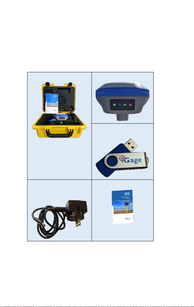
What’s in the iG5 Box?
Other than a suitable tripod or pole, iG5 receivers are sold as
complete kits, ready to record OPUS compatible static raw
data sets.
Each receiver kit includes these items:
A Hard-Shell Carry Case
iG5 GNSS Head
The iG Download tool on a
thumbdrive:
Data Cable: Type-C to Type-A USB
and External Power / Charger
supply.
This User Manual

13 iG5 User Manual
Technical Assistance
If you have questions or issues with your receiver, support is
provided by iGage Mapping Corporation in Salt Lake City
Utah:
iGage Mapping Corporation
www.iGage.com
1545 South 1100 East STE 1
Salt Lake City UTAH 84105
+1-801-412-0011 support@igage.com
Warranty / Service
Please see the full warranty at the end of this manual for
details.
While advanced replacement programs are available, for
mission critical applications we recommending purchasing
Hot Spares.
Service is provided by iGage Mapping Corporation in Salt Lake
City Utah.
Safety Information
This manual describes the iG5 GNSS Receiver. Before you use
your receiver, please make sure that you read and
understand these warnings and safety requirements.
Warnings and Cautions
An absence of specific alerts does not mean that there are no
safety risks involved. Warning and Caution information is
intended to minimize the risk of personal injury and/or
damage to the equipment.

iG5 User Manual 14
Use and Care
The iG5 receiver is a field ready instrument; however, it is
also a delicate electronic instrument. Take suitable care to
avoid damage to the instrument.
Avoid dropping the receiver as it can change the phase center
of the antenna.
Avoid storing the receiver at excessive temperatures (hot or
cold) as it will damage the internal batteries.
Avoid storing the receiver at temperatures less than -20° F (-
29° C) and temperatures higher than 160°F (72°C) as it will
permanently reduce the battery capacity and life
Environment
GNSS receivers and especially the Lithium-Ion batteries
contained in them are like puppies: in the summer if you
leave them in your vehicle with the windows rolled up, you
will kill them.
DO NOT leave the iG5 or accessories inside a vehicle in the
summer. Temperatures higher than 160°F will permanently
reduce battery capacity and battery life.
The receiver is suitable for use and tested in a human
appropriate atmosphere, it is not suitable for use in explosive
environments.
Risk of Electrocution: Because of risk of electrocution it is very
dangerous to use poles or extensions in the vicinity of
overhead electrical lines. Maintain a safe distance from
overhead electrical delivery systems.
If the receiver is used on a pole during an electrical storm
there is a very high risk of being struck by lightning. Do not

15 iG5 User Manual
use the product during a thunderstorm. Lay the pole down on
the ground and get away from it.
Battery Safety and Disposal
The internal batteries are lithium-ion type cells. When they
wear out, the receiver must be returned to iGage for
replacement.
Battery Warnings
WARNING - Do not damage the rechargeable Lithium-ion
battery. A damaged battery can cause an explosion or fire,
and can result in personal injury and property damage.
To prevent injury or damage:
Do not expose the receiver to fire, high temperature, or
direct sunlight.
Do not store the receiver inside a vehicle during hot
weather.
WARNING - Avoid contact with the rechargeable Lithium-ion
battery if it appears to be leaking. The battery fluid is
extremely corrosive, and contact with it will result in personal
injury and/or property damage.
If battery fluid gets into your eyes, immediately rinse your
eyes with clean water and seek medical attention. Do not rub
your eyes!
If battery fluid gets onto your skin or clothing, immediately
use clean water to wash off the battery fluid.
Battery Life
A large internal Lithium-Ion battery is installed in the receiver.
It is not user serviceable. The expected runtime is 12- to 14-
hours at normal temperatures.
For shipping regulation compliance, batteries are nearly fully
discharged when the receiver is shipped to you. You will need
to charge the receiver before first use.

iG5 User Manual 16
If you plan on running the receiver in static mode for longer
than 12-hours, it is suggested that attach an external battery
pack.
The Anker PowerCore 10000 (approximately $20 on Amazon)
style battery is a good choice and will extend receiver
operation for a full day.
Larger external batteries will extend operation for even
longer periods.
Battery Charging
When connected to the supplied charger with the receiver
turned off, at normal temperatures, the receiver will charge
about 40% per hour, to 80% and then tapper to a full charger
after another hour.
When the receiver is turned on the charging rate is slower
and the receiver may not charge past 95%.
When the receiver is plugged into a computer instead of the
supplied charger, the charging rate may be slower.
Radio Notices
FCC Notice: iG5 GNSS receivers comply with the limits for a
Class B digital device, pursuant to the Part 15 of the FCC rules
when it is used in the Portable Mode.
Operation is subject to the following two conditions:
•This device may not cause harmful interference
•this device must accept any interference received,
including interference that may cause undesired
operation
FCC Compliance:

17 iG5 User Manual
Function
FCC-ID
Module Type
Model iG5
Device i73
SY4-A2020
Assembly
Bluetooth Radio
Radiated output power from the internal Bluetooth radio is
far below FCC radio frequency exposure limits. The Bluetooth
radio operates within guidelines for radio frequency safety
standards and recommendations, which reflect the consensus
of the scientific community.
The level of energy emitted is far less than the
electromagnetic energy emitted by wireless devices such as
mobile phones. However, the use of wireless radios may be
restricted in some situations or environments, such as on
aircraft or near blasting areas.
Front Panel Operation
Pushbuttons
The receiver’s front panel has two pushbuttons Power and
Record.
On/Off Pushbutton
Press the Power button (right-hand) for 3-seconds and
release to turn the receiver ON.
If the receiver is ON, press the Power button for 3-seconds to
turn the receiver OFF.

iG5 User Manual 18
When the receiver turns on, all four LED’s will light for ½
second.
Files Pushbutton
iG5 receivers are factory configured to automatically begin
recording after the receiver is turned on and tracking
satellites. (You probably won’t ever need to use the Files
button.)
If the receiver is recording data, pressing and holding the Files
button on the left-hand-side for 10-seconds toggles the
receiver from collecting data, to not collecting data and
closes the current occupation file. The yellow Files LED will
stop flashing when recording stops.
When the receiver is not recording, pressing and holding the
record button for 10-seconds will open a new observation file
and begin collecting observation data.
LED Indicators
There are four LED indicators on the receiver:
Power ()
Red Power is ON. External power is not
connected.
Amber The internal battery is charging.
Green Internal battery is fully charged.
SV’s (Satellite Count)
Blue Blinks once for each tracked satellite,
waits 5-seconds, repeats. If no satellites are
tracked, will blink once every 5-seconds.
Serial
Amber Blinks amber when the receiver is not fixed
and correction data received.

19 iG5 User Manual
Green Blinks green when the receiver is fixed and
correction data is received.
Files
Amber Blinks each time a data epoch is stored to
a static file.
Push and hold the Files button for 10-seconds
to toggle data recording ON and OFF.
The LED blinks when recording is active.
Secret Reset Mainboard Mode
With the receiver turned ON, push and hold the Files button
while clicking the Power button 5-times. This will initialize the
OEM receiver engine.
Recording Rate
The iG5 receiver is configured to automatically record raw
files with a 1 Hz rate.
The receiver has 6,741,970,900 bytes available for user
observation files. The receiver will generate approximately 14
MB per hour with normal constellations at 1Hz so
approximately 481 hours (20 24-hour days) of continuous
data can be stored on the receiver.
If you need to store data longer without downloading, you
can set the recording rate to 5-seconds or 30-seconds.
The receiver is set to automatically delete the oldest file (Ring
Buffer) as needed to record new files which will overwrite the
oldest files on the receiver.

iG5 User Manual 20
Collecting Static Data
OPUS-Static, OPUS-RS and OPUS-Projects
Additional information on OPUS-Static and OPUS-Rapid
Static can be found in the ‘OPUS’ section of this manual.
Please read the “Best OPUS Practices for New and
Experienced Users” section of this User Manual on page 50.
It will save you time and failed jobs.
Prior to using the receiver, fully charge the battery to ensure
that the static occupation is not interrupted by power failure.
When fully charged will run the receiver for about 12 hours at
60 degrees F.
When making occupations longer than 8-hours, or at low
temperatures, you should provide external power to the
receiver.
1. Place a freshly charged battery into the
receiver.
2. Place the receiver above the point you
want to survey.
3. Rotate the receiver so the pushbutton
panel faces the North.
4. Level the receiver.
5. Record the ‘Vertical Height’from the top
of the survey mark to the bottom of the
receiver; alternatively, you may measure
a ‘Slant Height’to the bottom of the
blue rubber gasket at the minimum side
radius.
6. At a minimum, make a careful note of
the following items in your field book:
Start Time and Date
Instrument Height (HI)
PID (Point ID, Mark Name)
Description
7. Turn on the receiver. After 30 to 90-seconds, check that
5 or more satellites are tracked (the blue LED will blink 5
or more times.) The amber “Files” LED will begin to flash
Table of contents
Other iGage Receiver manuals


