Fullpower MotionX-GPS HD User manual

US and Foreign Patents Granted and Pending.Fullpower®, MotionX®, TapTap®, and ShakeShake® are registered trademarks of Fullpower
Technologies, Inc.Touch-N-Set™, Tilt‘n Roll™, and TiltTilt™ are trademarks of Fullpower Technologies, Inc.All other trademarks remain the
property of their respective owners. © Copyright 2003-2011 Fullpower Technologies, Inc. All rights reserved.
1
User Manual
Revision 16.1
June 2011
Fullpower Technologies, Inc., makers of MotionX™
MotionX-GPS HD

Table of Contents
1. Overview 3
2. Menu 4
3. Go To 5
4. Record Track 8
5. Share 9
6. Auto Live Updates 10
7. My Position 11
8. Map 12
9. Waypoints 19
10. Tracks 21
11. Compass 24
12. Map Downloads 26
13. Setup 30
US and Foreign Patents Granted and Pending.Fullpower®, MotionX®, TapTap®, and ShakeShake® are registered trademarks of Fullpower
Technologies, Inc.Touch-N-Set™, Tilt‘n Roll™, and TiltTilt™ are trademarks of Fullpower Technologies, Inc.All other trademarks remain the
property of their respective owners. © Copyright 2003-2011 Fullpower Technologies, Inc. All rights reserved.
2
!

1. Overview
The most accurate and reliable solution for the iPad, MotionX-GPS HD embeds the
functionality of an advanced handheld GPS unit into a simple and intuitive iPad
application. Use MotionX-GPS HD with your iPad during outdoor activities such as
hiking, sailing, off-roading, flying, geocaching, or exploring new places. MotionX-GPS
HD is exclusively designed and optimized for the iPad. While the WiFi iPad does not
contain a GPS chipset, many of the features are still useful in WiFi mode.
GPS requires a direct “line-of-sight” to communicate with satellites. Your 3G iPad must
have a clear view of the sky to locate at least three satellites in order to give accurate
position information. If you are indoors, in a wooded area, surrounded by buildings, or in
the back seat of your car, for example, you may be unable to acquire an accurate GPS
signal.
US and Foreign Patents Granted and Pending.Fullpower®, MotionX®, TapTap®, and ShakeShake® are registered trademarks of Fullpower
Technologies, Inc.Touch-N-Set™, Tilt‘n Roll™, and TiltTilt™ are trademarks of Fullpower Technologies, Inc.All other trademarks remain the
property of their respective owners. © Copyright 2003-2011 Fullpower Technologies, Inc. All rights reserved.
3
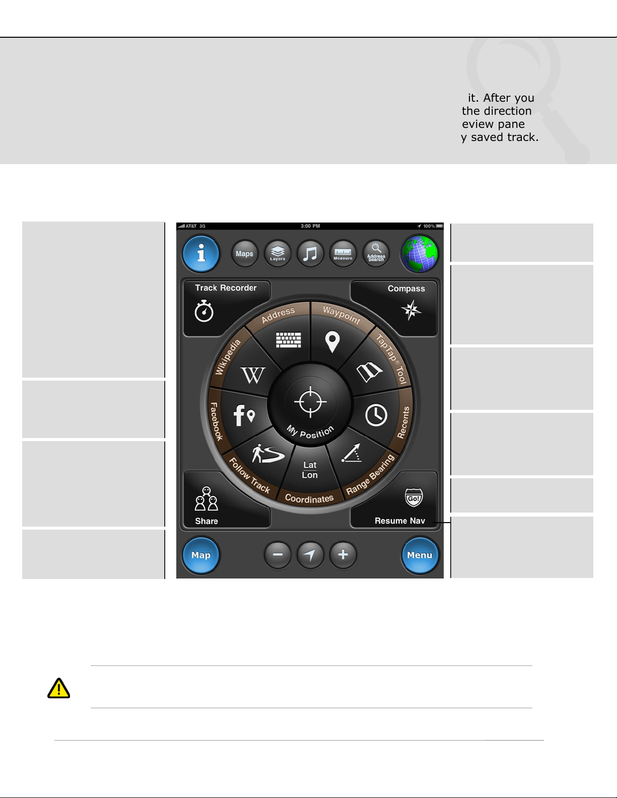
Info: Access the in-app
help file from any page.
GPS signal indicator.
Touch to toggle modes.
GPS: Outdoor GPS mode
(3G iPad only). Accuracy
30-300 feet.
Wifi: Approximate
position using Wifi or
network triangulation.
Accuracy 100 feet to 3
miles.
Manual: Offline mode;
not searching for signal.
Manually enter your
position, no real-time
location information.
Menu: Return to the
main menu from any
page.
GPS: Quickly access the
Map screen from any
page.
Search: Perform a search
to find the geocoded
location, including:
•Country name (e.g.
“Italy”)
•Landmark (e.g. “Mount
Everest”)
•Address
•Lat / Lon
iPod/Lock: Access iPod
controls from any page;
the control panel slides
up and down in when this
button is touched. The
screen lock is also found
in this control panel.

2. Menu
The MotionX Menu provides access to the various capabilities of MotionX-GPS HD. View
and mark your current position, navigate to a waypoint, view and store onboard maps,
access your saved waypoints, view the navigation instruments, and access the settings
from this page.
Each menu button is explained here briefly. Additional details for each function are
outlined in the subsequent sections of this manual.
1While actively recording a track, the icon blinks between green and white.
2With Auto Live Updates active, the icon blinks between green and white.
Auto Live Updates:
Setup/controls for
sharing your position with
others in real-time.2
US and Foreign Patents Granted and Pending.Fullpower®, MotionX®, TapTap®, and ShakeShake® are registered trademarks of Fullpower
Technologies, Inc.Touch-N-Set™, Tilt‘n Roll™, and TiltTilt™ are trademarks of Fullpower Technologies, Inc.All other trademarks remain the
property of their respective owners. © Copyright 2003-2011 Fullpower Technologies, Inc. All rights reserved.
4
Setup: Access the
various user-based
settings and controls.
My Position: View
current position, create a
waypoint, view signal
strength and accuracy.
Tracks: View a list and
details of your saved
tracks.
Waypoints: View a list
of your saved waypoints;
view GPX file import
instructions.
Auto Live Updates:
Setup/controls for
sharing your position with
others in real-time.2
Record Track: Open the
GPS stopwatch to record
a track.1
Map: View maps, with
tracks, waypoints, and
optional gridlines
overlaid.
Compass: Current
heading, SOG, VMG,
ETA, waypoint distance
& bearing to wypt.
Share: Share your
current position, track or
waypoint via email,
Facebook, or Twitter.
My Position: View/
share current position,
create a waypoint, take
a photo, view signal
strength.

3. Go To
Define a destination waypoint using a variety of methods and navigate to it. After you
select a waypoint and start navigating, the Map screen appears showing the direction
and bearing to the waypoint. View your saved waypoints in a live map preview pane
prior to initiating navigation. There is also an option to follow a previously saved track.
The corner buttons provide quick access to commonly used functions.
1If UTM, MGRS, or OSGB is selected as the coordinate system, the input format will
reflect the appropriate system.
US and Foreign Patents Granted and Pending.Fullpower®, MotionX®, TapTap®, and ShakeShake® are registered trademarks of Fullpower
Technologies, Inc.Touch-N-Set™, Tilt‘n Roll™, and TiltTilt™ are trademarks of Fullpower Technologies, Inc.All other trademarks remain the
property of their respective owners. © Copyright 2003-2011 Fullpower Technologies, Inc. All rights reserved.
5
TapTap™ tool: Create a
new waypoint by tapping
twice on the map. A new
waypoint will be created
and saved.
Coordinates: Define the
waypoint coordinates.1
Address input:
•Country name.
•Location or landmark,
e.g. “Mount Everest”.
•Address, options:
-full address
-city name
-state/province
-zip/postal code
•Lat / Lon, for example
“41.89 N, 87.61 W”.
Range/Bearing: Enter a
range (distance) and
bearing (degrees) from
your current position.
Follow Track: Follow
one of your saved tracks
(plotted on the map).
Waypoint: Select from
your saved waypoints.
Recently Found: View
your waypoints sorted by
date to quickly find
recently saved points.
Facebook: View your
friends’ Facebook Places
check-ins, and/or post
your current location for
your friends to see.
Wikipedia: View POIs
around you or in a
specified location; read
the associated articles.
Resume Nav: Select a
recent waypoint for
navigation (Stop Nav
while navigating).

3. Go To (continued)
Navigate to Waypoint
1While using MotionX-GPS HD in manual mode (GPS and Wifi off), navigation to a
waypoint will begin from the location you have identified as your “Home” waypoint. Edit
the Home waypoint to change where navigation begins while using manual mode.
US and Foreign Patents Granted and Pending.Fullpower®, MotionX®, TapTap®, and ShakeShake® are registered trademarks of Fullpower
Technologies, Inc.Touch-N-Set™, Tilt‘n Roll™, and TiltTilt™ are trademarks of Fullpower Technologies, Inc.All other trademarks remain the
property of their respective owners. © Copyright 2003-2011 Fullpower Technologies, Inc. All rights reserved.
6
!
Points of Interest:
Select pre-loaded POIs
from around the world.
Start Nav: Initiate
navigation to the selected
waypoint.
Waypoint name, notes,
and lat/lon may be edited
in the same way it is
edited from the
Waypoints page.
Home: Navigate to the
point saved as “Home”.1
All Waypoints: Select
from your list of saved
waypoints.
View a preview of your
waypoint on the map.
The map type matches
your selected preference
on the Map page.
Crosshairs: Center the
map around the waypoint
if you scroll or zoom.

3. Go To (continued)
Wikipedia POI Search
Search the full catalog of Wikipedia articles that include coordinate information
(lat,lon). Access complete articles directly within MotionX-GPS HD.
US and Foreign Patents Granted and Pending.Fullpower®, MotionX®, TapTap®, and ShakeShake® are registered trademarks of Fullpower
Technologies, Inc.Touch-N-Set™, Tilt‘n Roll™, and TiltTilt™ are trademarks of Fullpower Technologies, Inc.All other trademarks remain the
property of their respective owners. © Copyright 2003-2011 Fullpower Technologies, Inc. All rights reserved.
7
!
Select an entry or touch
a flag to select a POI.
Specify Location:
Define a location for your
search. This may be a
city or a landmark (e.g.
“Golden Gate Bridge”).
Show More Results:
Expand the search radius.
Next: Read the Wikipedia
summary, and optionally
view the full article.
Initiate navigation to this
POI from the following
screen.
The map type will default
to your selected
preference from the Maps
menu.

4. Record Track
Record a track of your hikes, drives, flights, sails or other outdoor activities. Once
saved, the track is added to the Tracks log.
!For the Wifi-only iPad, distance and speed values may be inaccurate due to the fact that
location accuracy is only between 100 feet and 3 miles in Wifi mode. A reliable GPS
signal (indicated by a blue spinning globe) is required for accurate results.
US and Foreign Patents Granted and Pending.Fullpower®, MotionX®, TapTap®, and ShakeShake® are registered trademarks of Fullpower
Technologies, Inc.Touch-N-Set™, Tilt‘n Roll™, and TiltTilt™ are trademarks of Fullpower Technologies, Inc.All other trademarks remain the
property of their respective owners. © Copyright 2003-2011 Fullpower Technologies, Inc. All rights reserved.
8
Avg Speed: Average
speed or pace; select
units preference in
Settings.
Distance: Total recorded
track distance.
Gradient: Current
gradient (based on
change in altitude).
Graphs: Speed and
altitude graphs are
populated after the track
is initiated. Graphs are
updated once per
minute; each interval is
an average over the past
minute of travel.
Max Speed: Maximum
speed achieved over the
course of your track.
Ascent Descent: Total
ascent / descent over the
course of your track
(based on changes in
altitude).
Speed: Current speed of
travel; select units
preference in Settings.
The tracking ball appears
when you tap and hold
the graph. Slide your
finger across the screen
to move the ball along
the graph. Instantaneous
values are shown in the
upper and lower right
corners.

5. Share
Share your current position, current track, saved waypoint or a saved track.
Share via email, Facebook, or Twitter.
The following screenshot demonstrates sharing your current position; sharing your
current track is similar. Choosing to share a saved track or waypoint takes you to your
list of saved tracks or waypoints, where you can make a selection for sharing.
1 To facilitate a faster sharing experience, go to Menu > Setup > Share to enter
email addresses to share with and to sign into your accounts.
Attached to the email share will be three files: a KMZ file (for Google Earth), a GPX file
(GPS eXchange format), and a JPEG image file showing your track or waypoint on a
map. If a photo is associated with the track or waypoint, the photo will be attached
instead of the track/waypoint map image.
US and Foreign Patents Granted and Pending.Fullpower®, MotionX®, TapTap®, and ShakeShake® are registered trademarks of Fullpower
Technologies, Inc.Touch-N-Set™, Tilt‘n Roll™, and TiltTilt™ are trademarks of Fullpower Technologies, Inc.All other trademarks remain the
property of their respective owners. © Copyright 2003-2011 Fullpower Technologies, Inc. All rights reserved.
9
Preview Pane:
•Displays your selected
track or waypoint
overlaid on a map.
•Change the map type
from the Maps page.
•Pinch to zoom, swipe to
pan the view.
•The region shown is
captured as a JPEG
image file and shared
along with the track or
waypoint details.
Touch any field to edit
the text.
Share with up to six
email addresses at once.
Crosshairs: Center the
map around the track if
you scroll or zoom.
Display Name:
This name will be posted
with your shared
waypoint or track
information to let your
friends know who you
are.
Share to email, Twitter,
and/or Facebook.1
Post a comment to go
along with your waypoint
or track (up to 120
characters).

6. Auto Live Updates
Share your real-time position automatically via Facebook, Twitter, email, or displayed
on the maps of friends using MotionX-GPS HD. Auto Live Position Updates will run (GPS
chipset remains active) when MotionX-GPS HD is backgrounded if Setup > Multitasking
is set to either Optimized or Always On. A data connection is required for this feature.
1 Auto Live Map Updates Setup:
• Define a 5-digit channel using the picker wheels. Share your channel with friends who want to
see your location.
• Define an interval for broadcasting your location (ranging from 30sec to 10min). Your friends’
latest known locations are updated at the interval they have selected.
• Select a radius within which you would like to display your friends’ locations.
• Select a time interval to display your friends’ last known position updates. Choosing 12 hours,
for example, will allow you to see their last position broadcast for 12 hours after they have
stopped sending updates.
• TapTap® a friend’s location sign on the Map to view the time of their last location update.
US and Foreign Patents Granted and Pending.Fullpower®, MotionX®, TapTap®, and ShakeShake® are registered trademarks of Fullpower
Technologies, Inc.Touch-N-Set™, Tilt‘n Roll™, and TiltTilt™ are trademarks of Fullpower Technologies, Inc.All other trademarks remain the
property of their respective owners. © Copyright 2003-2011 Fullpower Technologies, Inc. All rights reserved.
10
On/Off: Enable or
disable Automatic Live
Position Updates.
Map: Share your real-
time position with friends
who are also using
MotionX-GPS. Go to the
Map page to see their
latest position update.
Your friends will see your
latest update on their
Map page. 1
Configure your live
updates sharing
preferences.1

7. My Position
Quickly view your current geographic location, altitude, and GPS signal strength from
the My Position page. Create a waypoint to mark your current position with one click.
Use the emergency button to mark your position and start navigating back to it.
1 “Wifi/Triangulation” indicates your iPad is using network triangulation to estimate your
position. Location values may be inaccurate by several hundred feet up to a few miles.
US and Foreign Patents Granted and Pending.Fullpower®, MotionX®, TapTap®, and ShakeShake® are registered trademarks of Fullpower
Technologies, Inc.Touch-N-Set™, Tilt‘n Roll™, and TiltTilt™ are trademarks of Fullpower Technologies, Inc.All other trademarks remain the
property of their respective owners. © Copyright 2003-2011 Fullpower Technologies, Inc. All rights reserved.
11
Mark Wypt: Create a
new waypoint using your
current position.
Last Valid Fix: Elapsed
time since the last valid
location point.
Lat/Lon: Current
location. Choose between
Lat/Lon, UTM and MGRS
coordinate systems.
Altitude: Current
altitude (feet or meters).
GPS Signal: 1
Green: Strong signal.
Yellow: Average signal.
Red: Weak signal;
position information
may be inaccurate/
unreliable. A question
mark will appear in the
position data fields.
Tips/Links: Tips and
links to help you learn
more about the app.
Accuracy: Horizontal
accuracy.
Emergency: Mark your
current position and
initiate navigation back
to this point. Useful for
man-overboard type
situations.
Check in: Check in to
Facebook Places.

8. Map
The MotionX Map view shows your position and a track of your movement. Choose
from ten different map types, including road, aerial, hybrid, terrain, and marine.
Optionally display your waypoints and a coordinate grid overlay, use the distance tool
to measure distance and bearing, and search for an address with the search tool.
1 If there are multiple waypoints in the same area, a group sign indicating the number of
waypoints will be shown. TapTap® the sign or zoom to see the individual waypoints.
Use the MotionX TapTap™ tool to create a new waypoint on the map. Move the map or
change zoom levels to position the marker. As the map is moved, the coordinates of the
waypoint as well as the range and bearing from your current location are displayed at
the lower right of the map.
US and Foreign Patents Granted and Pending.Fullpower®, MotionX®, TapTap®, and ShakeShake® are registered trademarks of Fullpower
Technologies, Inc.Touch-N-Set™, Tilt‘n Roll™, and TiltTilt™ are trademarks of Fullpower Technologies, Inc.All other trademarks remain the
property of their respective owners. © Copyright 2003-2011 Fullpower Technologies, Inc. All rights reserved.
12
Waypoint markers:
Saved point of
interest/waypoint.
Navigation to a
waypoint started.
Waypoint to which
you are navigating.
Initial position at
app launch.
Single waypoint
marker.
Grouped waypoints:
used when there
are many waypoints
in close proximity.1
Position estimated with
Wifi or network
triangulation.
Position unknown; no
location signal.
Current position;
good GPS signal.
Weak GPS signal
(borderless blue circle).
“Headlight” indicates
direction up mode.
Arrows:
Track recorder
started.
TapTap® or zoom in
to see the individual
waypoints in a group.
Track recorder
stopped.

8. Map (continued)
Map Controls
1Enter an address, location, or Lat/Lon and save the search result as a waypoint. Then
initiate navigation to this point with one click. Location entry may include the name of a
landmark (”Mount Everest”), a park (”Yosemite”), or a point of interest (”Golden Gate
Bridge”), for example.
US and Foreign Patents Granted and Pending.Fullpower®, MotionX®, TapTap®, and ShakeShake® are registered trademarks of Fullpower
Technologies, Inc.Touch-N-Set™, Tilt‘n Roll™, and TiltTilt™ are trademarks of Fullpower Technologies, Inc.All other trademarks remain the
property of their respective owners. © Copyright 2003-2011 Fullpower Technologies, Inc. All rights reserved.
13
!
+ / - : Zoom in & out.
Touch to center
the map around
your current
position.
Position centered;
direction-up.
Position centered;
course up.
Full screen: View the
map in full screen mode.
Maps: Select your
preferred map type.
Includes several options
for road, terrain,
satellite, hybrid, and
marine charts.
Layers: Select what
elements are displayed
on the map: choose to
display gridlines, tracks,
and/or waypoints.
Measure: Measure the
distance and bearing
between any two points
on the map.
Search: Perform a
search to find the
geocoded location.1

8. Map (continued)
Map Catalog
US and Foreign Patents Granted and Pending.Fullpower®, MotionX®, TapTap®, and ShakeShake® are registered trademarks of Fullpower
Technologies, Inc.Touch-N-Set™, Tilt‘n Roll™, and TiltTilt™ are trademarks of Fullpower Technologies, Inc.All other trademarks remain the
property of their respective owners. © Copyright 2003-2011 Fullpower Technologies, Inc. All rights reserved.
14
!
Map sources:
• MotionX: road, terrain;
uses OpenStreetMap data.
• Bing: road, aerial, hybrid.
• Google: road, aerial,
hybrid.
• NOAA: marine (U.S. only).
Map types:
•Auto Up: rotates the underlying map to maintain an upward heading. Uses Direction Up (magnetic
compass) below 5 mph and Course Up (GPS orderly changes in position) above 5 mph. This feature
is not available for Google Maps.
•Direction Up: rotates the underlying map to maintain an upward heading, using the magnetic
compass. This feature is not available for Google Maps.
•Course Up: uses orderly changes in position from satellite data to rotate the map to maintain an
upward heading. Speed of travel must be more than a few mph (or km/h). This feature is not
available for Google Maps.
•North Up: displays the map with North at the top.
Expand the map type to
see the various map
sources.
Due to Microsoft
restrictions on Bing maps
and Google restrictions
on Google maps, these
maps types can’t be
cached or stored
onboard. By contrast,
MotionX road and terrain
maps, and NOAA marine
charts may be cached
and stored onboard. See
the Map Downloads
section for details.
Map Options:
Direction-up.
Course-up.
Downloadable.

8. Map (continued)
Map Layers
US and Foreign Patents Granted and Pending.Fullpower®, MotionX®, TapTap®, and ShakeShake® are registered trademarks of Fullpower
Technologies, Inc.Touch-N-Set™, Tilt‘n Roll™, and TiltTilt™ are trademarks of Fullpower Technologies, Inc.All other trademarks remain the
property of their respective owners. © Copyright 2003-2011 Fullpower Technologies, Inc. All rights reserved.
15
!
Overlays: Toggles the
display of a coordinate
grid: Lat/Lon, UTM, or
MGRS.
Tracks: Toggles the
display of tracks on the
map on/off.
Auto: Toggles the
display of Points of
Interest waypoints on
the map on/off.
My Waypoints: Toggles
the display of your
saved waypoints on the
map on/off.
The Layers button
controls what elements
are displayed on the
map.
POI: Toggles the
display of Points of
Interest waypoints on
the map on/off.
Speed/Head: Display
your current speed and
heading information
near the top of the map.

8. Map (continued)
Distance Measurement Tool
US and Foreign Patents Granted and Pending.Fullpower®, MotionX®, TapTap®, and ShakeShake® are registered trademarks of Fullpower
Technologies, Inc.Touch-N-Set™, Tilt‘n Roll™, and TiltTilt™ are trademarks of Fullpower Technologies, Inc.All other trademarks remain the
property of their respective owners. © Copyright 2003-2011 Fullpower Technologies, Inc. All rights reserved.
16
!
The green crosshairs
represents the starting
point (from which the
bearing is computed.)
Use the Measure Tool to
measure distance and
bearing between any
two points on the map.
The red crosshairs
represents the end
point.

8. Map (continued)
Search
US and Foreign Patents Granted and Pending.Fullpower®, MotionX®, TapTap®, and ShakeShake® are registered trademarks of Fullpower
Technologies, Inc.Touch-N-Set™, Tilt‘n Roll™, and TiltTilt™ are trademarks of Fullpower Technologies, Inc.All other trademarks remain the
property of their respective owners. © Copyright 2003-2011 Fullpower Technologies, Inc. All rights reserved.
17
!
Search: Perform a
search to find the
geocoded location.
A waypoint will be
created to identify the
location; the Notes field
will be auto-populated
with your search query
input.
Hide the keyboard.
Initiate search.
Search queries may
include the following
input formats:
•Country name, for
example “France”.
•Location or landmark,
for example “Golden
Gate Park” or “Mount
Everest”.
•Address, options:
-full address
-city name
-state/province
-zip/postal code
•Lat / Lon, for example
“41.89 N, 87.61 W”.

8. Map (continued)
Track Types
A solid blue line traces your path when a GPS signal is active. When
using WiFi mode, a solid blue line plots a path between WiFi access
points.
A dotted blue line represents an interpolated path between two points
when signal has been lost.
A solid red line represents your path while recording a track with the
Track Recorder. Use the "Start Track", "Pause Track" and "Save Track"
controls on the MotionX-Track Recorder page to record and save your
track.
A dashed green line from the arrow indicates the path to the waypoint
you have chosen as your destination using the Start Nav button.
A solid orange line represents a previously recorded track that is being
followed. A green start flag indicates the start of the track and a
checkered end flag indicates the end.
US and Foreign Patents Granted and Pending.Fullpower®, MotionX®, TapTap®, and ShakeShake® are registered trademarks of Fullpower
Technologies, Inc.Touch-N-Set™, Tilt‘n Roll™, and TiltTilt™ are trademarks of Fullpower Technologies, Inc.All other trademarks remain the
property of their respective owners. © Copyright 2003-2011 Fullpower Technologies, Inc. All rights reserved.
18
!

9. Waypoints
A waypoint is a set of coordinates that uniquely identifies a geographic location. From
this page you can create new waypoints and access your saved waypoints, sorted by
name, date, or proximity, and view the Auto waypoints and included POIs. Quickly view
your saved waypoints in a live map preview pane. Store up to 505 waypoints.
Waypoints are divided into three categories: All Waypoints, Auto Waypoints and Home
Waypoint. Waypoint folders allow you to group waypoints from a specific activity or trip
together. Included are folders for Recently Added, Import and Points of Interest, or you
can create your own custom folders.
1Auto waypoints can be edited and saved as one of "My Waypoints", but auto waypoints
cannot be manually deleted.
2When navigating in Manual Mode (without GPS), the range and bearing start from the
Home location you’ve defined. To change your Home position, create a new waypoint
using the TapTap® tool and select “Set as Home”.
3Use the ‘Init’ automatic waypoint to find your way back to your starting point (where
you launched the application) in case you get lost.
US and Foreign Patents Granted and Pending.Fullpower®, MotionX®, TapTap®, and ShakeShake® are registered trademarks of Fullpower
Technologies, Inc.Touch-N-Set™, Tilt‘n Roll™, and TiltTilt™ are trademarks of Fullpower Technologies, Inc.All other trademarks remain the
property of their respective owners. © Copyright 2003-2011 Fullpower Technologies, Inc. All rights reserved.
19
Select a waypoint to see
details, notes, etc., and
to access additional
options.
Sort waypoints by name,
date, or proximity to your
current location.
Auto Waypoints1
created automatically by
MotionX-GPS HD:
•Init (app launch)3
• Start Nav
• Destination
• Last Valid Fix
Home: Used as your
“current location” when
offline. When navigating
in Manual mode.2
POIs: Pre-loaded points
of interest to help you
start exploring.
The arrows show the
direction of the waypoint
from your current
position.
New Waypoint: Create a
new waypoint using one
of the following:
• Select point on map
• Enter coordinates
• Enter range/bearing
• Enter address
• Current location
Waypoint was
imported.
A photo is associated
with this waypoint.

9. Waypoints (continued)
Waypoint Details
US and Foreign Patents Granted and Pending.Fullpower®, MotionX®, TapTap®, and ShakeShake® are registered trademarks of Fullpower
Technologies, Inc.Touch-N-Set™, Tilt‘n Roll™, and TiltTilt™ are trademarks of Fullpower Technologies, Inc.All other trademarks remain the
property of their respective owners. © Copyright 2003-2011 Fullpower Technologies, Inc. All rights reserved.
20
!
Start Nav: Initiate
navigation to this
waypoint.
Notes: Default text is
creation time & date of
the waypoint. This field is
editable.
Back: Return to the list
of waypoints.
Bearing and Distance to
waypoint from your
current position.
Lat/Lon: Waypoint
location. UTM and MGRS
coordinate systems are
also available.
View a preview of your
waypoint on the map.
The map type matches
your selected preference
on the Map page.
Set as Home: Label this
waypoint as “Home”. For
use in Manual Mode.
Share: Share this
waypoint via email,
Facebook, and/or Twitter.
Take a photo (iPad 2) or
attach a photo from your
camera roll.
Crosshairs: Center the
map around the track if
you scroll or zoom.
Other manuals for MotionX-GPS HD
4
Table of contents
Other Fullpower GPS manuals