manuals.online logo
Brands
  1. Home
  2. •
  3. Brands
  4. •
  5. Magellan
  6. •
  7. GPS
  8. •
  9. Magellan MobileMapper CE - Hiking GPS Receiver User manual

Magellan MobileMapper CE - Hiking GPS Receiver User manual

California Resort Mecca Picks Magellan for Expanded GIS duties
Following a head-to-head competition, Palm
Desert chooses MobileMapper CE
Palm Desert, California
For the city of Palm Desert, Calif., the success of its eight-year-old
GIS program has been an ongoing source of municipal pride.
That’s why, when the city recently voted to expand the program to
include a wider variety of public works, traffic, recreational and
other municipal assets, it also decided to upgrade its aging,
outdated GPS data collectors with newer,moreaccurate, lighter-
weight equipment.
The clear choice for meeting the program’s growing demands: the
Magellan MobileMapper CE.
“Toselect the right equipment for the job, we compared four well-known and competing handheld GPS
receivers for accuracy, cost and accessibility to technical support,” said John Urkov, GIS technician. “Two
competitors were pretty much eliminated at the outset: one we considered too costly and the other didn’t
run ESRI’s ArcPad software. The remaining two candidates were put through an extensive head-to-head,
two-month field competition.”
The Winner for Accuracy
To help measure the accuracy of the two units, the GIS department was fortunate to have right in its own
parking lot a city benchmark whose position had recently been surveyed to within one centimeter. Virtually
everywork day for approximately two months, under a variety of weather and satellite conditions, the two
competing handheld units werecompared for accuracy and reliability. The daily comparisons yielded clear
results. “The MobileMapper CE outperformed its lone competitor more than 80 percent of the time,” Urkov
said. “Both pre-processed and post-processed, MobileMapper data was more defined and accurate
compared to the competing handheld, which produced points significantly morescattered and less accurate.”
The accuracy of the two units was also compared by walking and logging GPS polyline data for city features.
“We would walk and collect GPS data with each unit simultaneously and compare the lines using all our
georectified aerial photos and other GIS data which we knew was accurate. The Magellan MobileMapper
lines fell right wherethey should be while the competing unit – when it didn’tlose fix and lock up –
produced lines that were jagged and all over the place.”
The Winner for Cost and Support
Superior accuracy alone would have been reason enough to select the Magellan MobileMapper CE. But city
officials werein for a pleasant surprise; it was also the low- cost solution of all the receivers and about half
the cost of the unit it competed against and beat on accuracy.
We were delighted to find
the Magellan had superior
accuracy since it had the
lowest price by half,
John Urkov,
GIS technician
”
“
Case Study:
Palm Desert Manages Municipal
Assets with MobileMapper
™
CE
Palm Desert – MobileMapper CE
©2007 Magellan Navigation, Inc. All rights reserved. Magellan and MobileMapper are trademarks of Magellan Navigation, Inc.
All other trademarks areproperty of their respective holders. Rev (01May07)
Mobile Mapping Contact Information:
In USA +1 408 615 3970 ■Fax +1 408 615 5200
Toll Free (Sales in USA/Canada) 1800 922 2401
In South America +56 2 273 3214 ■Fax +56 2 273 3187
Email [email protected]
In France +33 2 28 09 38 00 ■Fax +33 2 28 09 39 39
In Germany +49 81 6564 7930 ■Fax +49 81 6564 7950
In Russia +7 495 956 5400 ■Fax +7 495 956 5360
In the Netherlands +31 78 61 57 988 ■Fax +31 78 61 52 027
Email [email protected]
In Singapore +65 6235 3678 ■Fax +65 6235 4869
In China +86 10 6566 9866 ■Fax +86 10 6566 0246
Email [email protected]
www.pro.magellanGPS.com
“We were delighted to find the Magellan had superior accuracy since
it had the lowest price by half,” said Urkov. “What’s more, when we
needed product support, we found Magellan engineers speedily pro-
vided good solid answers and solutions to our questions. Magellan
clearly offered the superior support team
and experience.”
Palm Desert’s Expanded GIS Program
GIS has grown in importance for Palm Desert, a wealthy residential and
resort community that’s home to more than its share of celebrities. Like
many cities, Palm Desert has found GIS to be a vital component to city
planning and administration. Four Palm Desert departments are the
first beneficiaries of the expanded GIS effort using the two new
Magellan MobileMapper CEs.
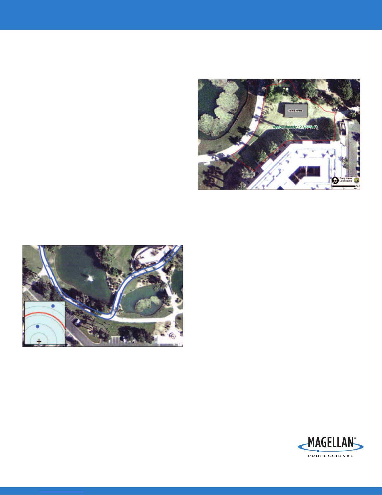
The Landscape Department is receiving a complete mapping of its
irrigation equipment, water meters, controllers and sensors. In
addition, the landscape areas they are charged with maintaining
are being defined in terms of square footage to better allocate
irrigation resources.
Hiking is a very popular pastime in Palm Desert. Existing trails were
not well inventoried and existing maps weren’t as accurate as officials
would like. In laying out new trails, the Planning Department needed
to know exactly where prospective trails would traverse, whether
through protected wildlife protected areas, particularly Bighorn
sheep areas that need to exclude unleashed dogs; through adjacent
jurisdictions, and even private lands that would require permission
and coordination.
The Traffic Department is undertaking a complete city-wide inventory
and mapping of all its signage, signals and traffic control vaults.
Once the inventory data base is complete, road crews will be able to
maintain the data base by logging additions, removals, modifications,
or location changes.
Public arthas long been important to Palm Desert. Throughout the city
there is a large amount of public art. A city ordinance requires public art
be incorporated into the landscaping of any new developments. One of
the projects being undertaken for the Art in Public Places Program is
mapping of the city’s public art, with all the information about each
piece described. Within the GIS layer, each item of art is hyperlinked to
apicture of the art with all the information about the piece, the artist’s
name, date of acquisition, etc.
Using ESRI’sArcPad Application Builder software, the GIS
department is building a customized ArcPad application for each of
the departments. Personnel from Landscape, Traffic, Planning and
Public Works, will soon be able to log changes directly into the
MobileMapper CEs, thus ensuring up-to-date GIS data. The low
cost and ease-of-use of the MobileMapper CE help make this
decentralization of data maintenance possible.
MobileMapper CE polygon data used to calculate squarefootage.
Polyline data accurately shows the measured sidewalk. Insert reflects MobileMapper CE's real-time
accuracy (blue spots) over 1 meter ring (red line); 1 foot rings (grey circles).

Other manuals for MobileMapper CE - Hiking GPS Receiver

1

Other Magellan GPS manuals

Magellan RoadMate 1440 - Automotive GPS Receiver Instruction Manual

Magellan

Magellan RoadMate 1440 - Automotive GPS Receiver Instruction Manual

Magellan MobileMapper CX - Hiking GPS Receiver User manual

Magellan

Magellan MobileMapper CX - Hiking GPS Receiver User manual

Magellan RoadMate 3045-LM User manual

Magellan

Magellan RoadMate 3045-LM User manual

Magellan FX324 MAP User manual

Magellan

Magellan FX324 MAP User manual

Magellan RoadMate 1200 - Automotive GPS Receiver User manual

Magellan

Magellan RoadMate 1200 - Automotive GPS Receiver User manual

Magellan NAV 6500 User manual

Magellan

Magellan NAV 6500 User manual

Magellan RoadMate 5175T Traveler Instruction Manual

Magellan

Magellan RoadMate 5175T Traveler Instruction Manual

Magellan RoadMate 3000T - Automotive GPS Receiver User manual

Magellan

Magellan RoadMate 3000T - Automotive GPS Receiver User manual

Magellan Maestro 4000 - Automotive GPS Receiver Parts list manual

Magellan

Magellan Maestro 4000 - Automotive GPS Receiver Parts list manual

Magellan RoadMate RV5365T-LMB User manual

Magellan

Magellan RoadMate RV5365T-LMB User manual

Magellan RoadMate Series User manual

Magellan

Magellan RoadMate Series User manual

Magellan NAV 1000 PLUS User manual

Magellan

Magellan NAV 1000 PLUS User manual

Magellan MobileMapper 6 User manual

Magellan

Magellan MobileMapper 6 User manual

Magellan RoadMate 9400-LM User manual

Magellan

Magellan RoadMate 9400-LM User manual

Magellan RoadMate 3000T - Automotive GPS Receiver User manual

Magellan

Magellan RoadMate 3000T - Automotive GPS Receiver User manual

Magellan ROADMATE 5045 User manual

Magellan

Magellan ROADMATE 5045 User manual

Magellan RoadMate 1200 - Automotive GPS Receiver Installation and operating instructions

Magellan

Magellan RoadMate 1200 - Automotive GPS Receiver Installation and operating instructions

Magellan RoadMate 360 - Automotive GPS Receiver User manual

Magellan

Magellan RoadMate 360 - Automotive GPS Receiver User manual

Magellan eXplorist 310 User manual

Magellan

Magellan eXplorist 310 User manual

Magellan eXplorist 200 - Hiking GPS Receiver User manual

Magellan

Magellan eXplorist 200 - Hiking GPS Receiver User manual

Magellan RoadMate 860T User manual

Magellan

Magellan RoadMate 860T User manual

Magellan RoadMate 3120 User manual

Magellan

Magellan RoadMate 3120 User manual

Magellan RoadMate 1412 Instruction Manual

Magellan

Magellan RoadMate 1412 Instruction Manual

Magellan Triton 300 User manual

Magellan

Magellan Triton 300 User manual

Popular GPS manuals by other brands

Yepzon Freedom user manual

Yepzon

Yepzon Freedom user manual

Winter 4 FGH 40 Installation and maintenance instructions

Winter

Winter 4 FGH 40 Installation and maintenance instructions

Pharos GPS 535x Getting started

Pharos

Pharos GPS 535x Getting started

SkyNanny GPS SkyNanny 1.0 quick start guide

SkyNanny GPS

SkyNanny GPS SkyNanny 1.0 quick start guide

Toplovo TL-202 manual

Toplovo

Toplovo TL-202 manual

Myto Billien OBU Basic service manual

Myto

Myto Billien OBU Basic service manual

PORTMAN GT3100 Operation and installtion manual

PORTMAN

PORTMAN GT3100 Operation and installtion manual

GNS 3000 user manual

GNS

GNS 3000 user manual

Beha-Amprobe AT-8000-EUR Series quick start guide

Beha-Amprobe

Beha-Amprobe AT-8000-EUR Series quick start guide

Datablaze Bolt 4GV user manual

Datablaze

Datablaze Bolt 4GV user manual

Novatel SPAN-SE user manual

Novatel

Novatel SPAN-SE user manual

Phonocar VM 077 instruction manual

Phonocar

Phonocar VM 077 instruction manual

Spireon FL4 instructions

Spireon

Spireon FL4 instructions

Novatel SMART2 Series Installation and Operation User Manual

Novatel

Novatel SMART2 Series Installation and Operation User Manual

Garmin GPSMAP 76CS owner's manual

Garmin

Garmin GPSMAP 76CS owner's manual

Gator M508 user manual

Gator

Gator M508 user manual

LX Navigation LX5000 V9.0 manual

LX Navigation

LX Navigation LX5000 V9.0 manual

Garmin DriveSmart 50 owner's manual

Garmin

Garmin DriveSmart 50 owner's manual

manuals.online logo
manuals.online logoBrands
  • About & Mission
  • Contact us
  • Privacy Policy
  • Terms and Conditions

Copyright 2025 Manuals.Online. All Rights Reserved.