RightWay Trine XL Version 1.0 User manual

RightWay GPS – The Right Features, The Right Price, RightWay GPS
RightWay GPS http://www.rightwaygps.com
Tel : +1.507.529.0041 Fax: +1.507.529.0041
Sales contact: sales@rightwaygps.com Technical support: support@rightwaygps.com
Address: 5050 75th Ave NW, Byron, Minnesota 55920 USA
Trine XL User’s Manual
Version 1.0

RightWay GPS – The Right Features, The Right Price, RightWay GPS
ii
Notice
We suggest that you carefully review the User Guide prior to using your GPS receiver.
The Trine XL receiver is a highly sensitive piece of electrical equipment that can be easily
damaged through misuse. In order to help you fulfill any warranty obligations, read the
User Guide in its entirety.
Utilizing the User Guide
This User Guide is an important part of the Trine XL. Reading the User Guide will help
you get the best performance from your receiver. In addition to helpful operating
information, the User Guide brings attention to potential safety concerns and warranty
obligations regarding the receiver. The Trine XL Receiver is a highly sensitive piece of
electrical equipment that can be easily damaged through misuse. The warranty will not
cover failure if the product is abused, misused or used for other than the intended
purpose. Read all the information carefully to avoid damage to the GPS receiver. The
Trine XL pairing code is 0000.
Revision History
Ver. Date Description
0.2 Dec. 20th, 2007 Initial draft
1.0 January 17, 2008 Final Draft

RightWay GPS – The Right Features, The Right Price, RightWay GPS
iii
Contents
1INTRODUCTION............................................................................................................................................ 1
1.1 APPLICATIONS ................................................................................................................................. 1
1.2 OUTLOOK ........................................................................................................................................ 1
1.3 MAIN FEATURES.............................................................................................................................. 2
1.4 SPECIFICATIONS............................................................................................................................... 4
1.5 ELECTRICALAND ENVIRONMENTAL DATA ...................................................................................... 5
1.6 LED DISPLAY.................................................................................................................................. 5
1.7 COMMUNICATION CONNECTIONS.................................................................................................... 6
1.8 BUNDLED TOOLS............................................................................................................................. 6
1.9 CERTIFICATIONS .............................................................................................................................. 7
1.10 RELATED DOCUMENTS.................................................................................................................... 7
2GETTING STARTED ..................................................................................................................................... 8
2.1 BLUETOOTH CONNECTION .............................................................................................................. 8
2.2 USB CONNECTION ........................................................................................................................ 10
2.3 VIEWING LOGGED TRACKS IN GOOGLE EARTH............................................................................ 10
2.4 TRACK BROWSING IN GOOGLE EARTH ......................................................................................... 12
2.5 PHOTO TAGGING............................................................................................................................ 15
3SOFTWARE INTERFACE...........................................................................................................................17
3.1 NMEAOUTPUT MESSAGES .......................................................................................................... 17
3.2 GPGGA-GLOBAL POSITIONING SYSTEM FIX DATA .................................................................... 18
3.3 GPGLL-GEOGRAPHIC POSITION -LATITUDE /LONGITUDE........................................................ 18
3.4 GPGSA-GNSS DOPAND ACTIVE SATELLITES........................................................................... 19
3.5 GPGSV -GNSS SATELLITES IN VIEW.......................................................................................... 19
3.6 GPRMC -RECOMMENDED MINIMUM SPECIFIC GNSS DATA ...................................................... 20
3.7 GPVTG -COURSE OVER GROUND AND GROUND SPEED............................................................. 20
3.8 GPZDA-SIRFTIMING MESSAGE ................................................................................................ 21
4TROUBLE SHOOTING...............................................................................................................................22
5FCC SAFETY STATEMENT.......................................................................................................................23
6WARRANTY.................................................................................................................................................. 24
RightWay GPS – The Right Features, The Right Price, RightWay GPS
1
1 Introduction
1.1 Applications
This dongle provides navigation and data logging functions via Bluetooth or a USB
connection. It can be used with devices such as a Smart phone, PDA, UMPC, MID, Notebook
PC, etc.
Power can be supplied via USB from a computer, the cigarette lighter car adapter, or the
battery bank directly. The battery bank can be charged via USB, the cigarette lighter car
adapter, or the AC wall charger.
1.2 Outlook
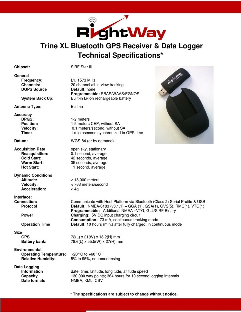
Trine XL
Dimensions of the Trine XL: 21 mm (W) x 72 mm (L) x 13.2 mm (H)

RightWay GPS – The Right Features, The Right Price, RightWay GPS
2
zBlue LED indicates the Bluetooth communication status and logging status
zGreen LED indicates GPS status and the remaining logging capacity.
Battery Bank
Dimension of battery bank: 55.5 mm (W) x 78.6 mm (L) x 27 mm (H)
1.3 Main Features
The Trine XL combines a smart design with excellent performance as well as the
combining a USB GPS, Bluetooth GPS, and Data logger into one device. In addition, the
Google Earth enabled features make every trip more useful.
Stylish
Smart Design
Lanyard hole for neck wearing
Convertible and easy to use
Wired & wireless communication support
Navigation support by wired (USB) and wireless (Bluetooth) connections
Convenient data management via either USB or Bluetooth connection
Convenient logging choices
Logging by distance
Logging by time
Logging by speed
Blue LED
Green LED

RightWay GPS – The Right Features, The Right Price, RightWay GPS
3
Logging status indication
Logging is enabled or disabled
Capacity is low, near full, or full
No worry of logging data loss
Logging stops when capacity is full
Logging capacity
130,000 way points, or 364 hours for 10 seconds logging interval
Special models available with double/quadruple storage.
Google Earth enabled with trip summary
Support both path or point view
Support both metric unit and imperial units
Convenient time zone translation for global use
Start/stop/excessive speed/maximum speed points information
Stop points mileage summary for paths between each start/stop points
Full trip mileage summary
Concise trip report
Trip filtering allows choosing specified logging interval
Useful trip reports easily generated
Compatible to various map applications
NMEA enabled: in turn can use features based on NMEA format
Photo tagging compatible: For example, photo tagging with www.locr.com*
Long working time
15 hour operating time when powered by BB-100 after first full charge.
Ultra-high performance
Full implementation of ultra-high performance SiRFstarIII single chip architecture
Note. * locr is a trademark of locr GmbH.

RightWay GPS – The Right Features, The Right Price, RightWay GPS
4
1.4 Specifications
GPS Receiver
Features Specifications
GPS chipset SiRFstarIII Chipset 20 channels, L1 frequency, C/A code
Horizontal Accuracy < 2.5m (Autonomous)
< 2.0m (WAAS)
(50% 24hr static, -130dBm)
Velocity Accuracy <0.01 m/s (speed)
<0.01°(heading)
(50%@30m/s)
Time accuracy 1µs or less
TTFF (Time to First Fix)
Hot Start: 1s
Warm Start: 35s
Cold Start: 42s
Sensitivity
(Autonomous)
Tracking: –159dBm
Acquisition: -142dBm
(-142dBm 28dB-Hz with 4dB noise figure)
Measurement data output
Update time: 1 second
NMEA output protocol: V.3.00
Baud rate: 4800 bps (8-N-1)
Datum: WGS-84
Default: GGA, GSA, RMC, VTG at 1Hz and GSV at 1/5Hz
Max. Altitude <18,000 m
Max. Velocity <1,852 km/hr
SBAS Support Optional WAAS, EGNOS
Dynamics <4g
Bluetooth
Version Version 2.0
Class 2
Communication range 10m
Communication profile SPP (Serial Port Profile)
Data Logging
Capacity 131,071 way points
Logging information Date, time, latitude, longitude, altitude, speed
User ID Length of 32 alpha-numeric characters
Data formats NMEA, KML, CSV

RightWay GPS – The Right Features, The Right Price, RightWay GPS
5
1.5 Electrical and Environmental Data
The Trine XL is built-in with a small backup battery for ephemeris data. The battery
bank can be used to power the Trine XL.
Power
Power consumption 73mA, continuous tracking mode
Power supply 3.3V ~ 5.5V
Battery Bank 1100mAh, Lithium-ion battery
Charging voltage: 4.2V~5.5V
Environmental
Item Trine XL Battery Bank
Operating temperature -20°C ~ +65°C -20°C ~ +60°C
Storage temperature -20°C ~ +80°C -20°C ~ +60°C
1.6 LED Display
Trine XL
Green
LED Always on (bright) as no position fix
Blinks in following way as position is fixed:
z1 second on, 1 second off: capacity < 80%
z2 seconds on, on 1 seconds off: capacity ≧80% and not full
z1 second on, 2 seconds off: capacity full
Blue
LED zAlways off as there is no Bluetooth connection and recording is off.
z0.25s on,10s off as there is no Bluetooth connection and recording is on.
z2s on, 0.5s off as there is Bluetooth connection and recording is on.
z2s on, 2s off as there is Bluetooth connection and recording is off.
z0.5s on, 0.5s off during data upload
Battery Bank
Orange
LED zBattery low: LED comes on until it is recharged or power is used up.
zCharging: LED on as it is under charging; off when charging is done.

RightWay GPS – The Right Features, The Right Price, RightWay GPS
6
1.7 Communication Connections
Wired
The Trine Xl can be connected to the USB port on a PC for real time navigation or to download
the logged data points. The appropriate drivers can be found on the product CD.
Bluetooth Wireless
The Trine XL can connect to a device via Bluetooth. The PIN code for Bluetooth connection is
0000. After the connection is established, it can be used for navigation and data logger
management.
1.8 Bundled Tools
The following tools are designed for running on PC Windows’s environment. They are for your
reference purpose only. We do our best to improve the compatibility with mostly used PC
windows environment. However, we do not guarantee the compatibility.
NaviViewer: This bonus tool is for checking GPS signal receiving status. One can also use other
GPS viewer tool to check GPS receiving status.
RW Log ManagerSoftware: for logging data management

RightWay GPS – The Right Features, The Right Price, RightWay GPS
7
1.9 Certifications
CE, FCC, BQB, RoHS
1.10 Related Documents
zUSB Driver Quick Installation Guide
zQuick Guide of NaviViewer
zQuick Guide to TRINE XL Bluetooth GPS Logger Receiver
zUser’s Guide to NaviLogManager

RightWay GPS – The Right Features, The Right Price, RightWay GPS
8
2 Getting Started
The Trine XL can provide positional data for navigation via a USB or Bluetooth
connection. The Trine XL can also be used for logging positional data for future use in
Google Earth, for Geo-Tagging Photos, or route management.
Both the USB and Bluetooth interfaces are connected via serial COM port.
2.1 Bluetooth Connection
To establish a Bluetooth connection with the hose device, please ensure the host
device has Bluetooth and it is enabled & ready for pairing.
Following is an example of establishing a Bluetooth connection on a Window’s PC
environment.
1. Find the Bluetooth application program and double click on it to start the
program. The following is an example. Please see the documentation on
your host device for directions.

RightWay GPS – The Right Features, The Right Price, RightWay GPS
9
2. Double click on the item of View devices in range. It shows the devices found.
3. Click on item of BT GPS Dongle to connect to the Trine XL.
4. It shows the SPP service is available. Double click on the item SPP slave on
BT GPS Dongle.
5. It shows it is connecting the GPS Dongle and may request you to enter the
Bluetooth pairing code (0000).

RightWay GPS – The Right Features, The Right Price, RightWay GPS
10
6. The Pairing code for Trine XL is 0000. Click on OK.
7. It shows the device as connected. Move cursor to the icon and it shows the
service as connected and COM port number 6 is used for this function.
8. The Trine XL and your host device are now connected. When using GPS
Navigation software, the COM port will need to be set to the port shown in the
pop-up.
2.2 USB Connection
To establish a USB connection, the Prolific PL-2303 USB driver should be installed.
This driver can be found on the product CD. After the drivers have been
successfully installed, a corresponding COM port will be available for use.
2.3 Viewing Logged Tracks in Google Earth
Before one can view the path that one has been visited, one needs to
1. Log the data in the Trine XL
The Trine XL is by default in data logging mode and it will log data

RightWay GPS – The Right Features, The Right Price, RightWay GPS
11
automatically according to setting of record options when powered on.
The logging could also be turned off using the RW Log Manager software.
2. Run RW Log Manager; click stop to stop logging, allowing you to set
parameters such time zone, units, speed definitions, and other triggers.
3. Retrieve the logged data, click Read to retrieve the logged points from the
Trine XL.
4. Choose the formats for conversion. For viewing from Google Earth, one
should check the boxes next to KML (path) and KML (point) via the button
Change Setting in the RW Log Manager software.
5. Click ‘Convert’ to convert the logged data. Name the converted files and
save them in a specific location.
6. Make sure Google Earth is ready. Download and install Google Earth if it is
not already installed.
7. Double click on the converted KML file or open it from Google Earth “File |
Open” menu and one will see the visited path, start/stop information, over
speed information, max speed information, mileage information etc.

RightWay GPS – The Right Features, The Right Price, RightWay GPS
12
2.4 Track Browsing in Google Earth
There are many functions in Google Earth. It’s not our focus to introduce these
functions. Instead, some hints are given to view the logged information.
In following picture, one can see the track of logged data displayed in Google
Earth.
The display content can be selected by adjusting the time scale.
Under the Places menu, one can see the logged data summary – paths and
points. Click on those items, the display will focus on corresponding data.

RightWay GPS – The Right Features, The Right Price, RightWay GPS
13
For example, click on item of MaxSpeed (the large red +)

RightWay GPS – The Right Features, The Right Price, RightWay GPS
14
Click on item of Stop 1. (One can also click on icon Stop 1 from the display directly.)
If one prefers to see the map information, remember to enable the roads selection
under Layers menu.

RightWay GPS – The Right Features, The Right Price, RightWay GPS
15
The map in local language would be displayed. Please note that not every area has
their corresponding map.
2.5 Photo Tagging
RW Log Manager does not support photo tagging directly. However, it’s easy to
geotag photos using free public domain photo-tagging software. Most photo tagging
tools support NMEAformat which can also be generated by the RW Log Manager
software.
Following is an example of photo tagging with locr from www.locr.com
The rule of thumb is
1. Specify where the NMEA file of logging data is saved.
2. Specify where the pictures are saved.
3. Choose the Google Earth KML format for photo display.
4. Display photos in Google Earth. (Google Earth should have been installed.)

RightWay GPS – The Right Features, The Right Price, RightWay GPS
16
Step 1: Click “Enter”
Step 2: Pick the NMEA messages to be converted
Step 3: Click “Enter”
Step 4: Pick the Photos
Step 5: Click for KML format conversion
Step 6: Click “Yes” to see photos on Google Earth
Locr’s web address: http://www.locr.com/
Step1: Click “Enter” here
Step2: Pick the NMEAmessages to be
Step3: Click “Enter”
Step4: Pick the photos
Step5: Click here for
KML format

RightWay GPS – The Right Features, The Right Price, RightWay GPS
17
3 Software Interface
3.1 NMEA Output Messages
The NMEA-0183 Output Messages are shown as below:
NMEA Record Descriptions
GPGGA Global positioning system fixed data: time, position, fixed type
GPGLL Geographic position: latitude, longitude, UTC time of position fix and status
GPGSA GPS receiver operating mode, active satellites, and DOP values
GPGSV GNSS satellites in view: ID number, elevation, azimuth, and SNR values
GPRMC Recommended minimum specific GNSS data: time, date, position, course, speed
GPVTG Course over ground and ground speed
GPZDA PPS timing message (synchronized to PPS)
The Trine XL uses the NMEA protocol of National Marine Electronics Association's
NMEA-0183 Version 3.00 interface specification. The Trine XL supports 7 types of sentences -
7 standard NMEA sentences (GPGGA, GPGLL, GPGSA, GPGSV, GPRMC, GPVTG, and
GPZDA).
The default output sentences are GPGGA, GPGSA, GPGSV, GPRMC, and GPVTG. The
UART communication parameters are 4800 bps, 8 data bits, 1 stop bit, and no parity. Other
output sentences, baud rate, and related configurations could be requested based on MOQ.
Single message example
$GPGGA,101229.487,3723.2475,N,12158.3416,W,1,07,1.0,9.0,M, , , ,0000*3E
$GPGLL,2446.8619,N,12100.2579,E,060725.000,A,A*7E
$GPGSA,A,3,05,02,26,27,09,04,15, , , , , ,1.8,1.0,1.5*11
$GPGSV,3,1,12,07,62,081,37,16,61,333,37,01,60,166,37,25,56,053,36*74
$GPGSV,3,2,12,03,43,123,33,23,32,316,34,14,17,152,30,20,16,263,33*78
$GPGSV,3,3,12,19,17,210,29,06,08,040,,15,06,117,27,21,05,092,27*7E
$GPRMC,101229.487,A,3723.2475,N,12148.3416,W,0.13,309.62,120598,,,A*7A
$GPVTG,,T,,M,0.00,N,0.0,K,A*13
$GPZDA,060526.000,20,06,2006,,*51
This manual suits for next models
1
Table of contents
Other RightWay GPS manuals

RightWay
RightWay Trine XL User manual

RightWay
RightWay GPS Navigator RW 200 User manual

RightWay
RightWay Tony Stewart SPOTTER User manual

RightWay
RightWay 210 User manual

RightWay
RightWay GPS Navigator RW 355 User manual

RightWay
RightWay GPS Navigator RW 430 User manual

RightWay
RightWay Mini-S3 User manual

RightWay
RightWay SPOTTER DALE JR. EDITION User manual

RightWay
RightWay RW400 User manual

RightWay
RightWay RW550 User manual