Weatherdock easyTRX2 S series User manual

Quick Instruction, Version 2.2 Page 1 of 43 pages
Weatherdock AG Sigmundstraße 180 90431 Nürnberg
Tel.:+49 911 37663835 www.weatherdock.de
„easyTRX2" and „easyTRX2-IS”
Manual
easyTRX2-IS
Class B AIS CS Transponder with integrated
Splitter Product No.: A050
easyTRX2
Class B AIS CS Transponder
Product No.: A034
Revision 2.4
Weatherdock AG.
Sigmundstraße 180
D-90431 Nürnberg
Tel.: +49 (0)911-376638-35
Fax: +49 (0)911-376638-40
www.weatherdock.com
Email: info@weatherdock.de

Quick Instruction, Version 2.2 Page 2 of 43 pages
Weatherdock AG Sigmundstraße 180 90431 Nürnberg
Tel.:+49 911 37663835 www.weatherdock.de
PLEASE READ THIS FIRST!
WEATHERDOCK GENERAL WARNINGS
All marine Automatic Identification System (AIS) units utilize a satellite
based system such as the Global Positioning Satellite (GPS) network or
the Global Navigation Satellite System (GLONASS) network to determine
position. The accuracy of these networks is variable and is affected by
factors such as the antenna positioning, how many satellites are used to
determine a position and how long satellite information has been re-
ceived for. It is desirable wherever possible therefore to verify both your
vessels AIS derived position data and other vessels AIS derived position
data with visual or radar based observations.
The easyTRX2 software is intended for use as an installation and confi-
guration tool. The application is not a navigation tool and should not be
used as such.
LICENSING
IMPORTANT: In most countries the operation of an AIS unit is included
under the vessels marine VHF license provisions. The vessel on to which
the AIS unit is to installed must therefore possess a current VHF radi-
otelephone license which lists the AIS system and the vessel Call Sign
and MMSI number. Please contact the relevant authority in your country
for more information. In accordance with a policy of continual devel-
opment and product improvement the easyTRX2 hardware and software
may be upgraded from time to time and future versions of the easyTRX2
may therefore not correspond exactly with this manual. When necessary
upgrades to the product will be accompanied by updates or addenda to
this manual. Please take time to read this manual carefully and to un-
derstand its contents fully so that you can install and operate your AIS
system correctly.
Information contained in this manual is liable to change without notice.
Weatherdock AG disclaims any liability for consequences arising from
omissions or inaccuracies in this manual and any other documentation
provided with this product.

Quick Instruction, Version 2.2 Page 3 of 43 pages
Weatherdock AG Sigmundstraße 180 90431 Nürnberg
Tel.:+49 911 37663835 www.weatherdock.de
DISCLAIMER
THIS SOFTWARE IS PROVIDED BY THE COPYRIGHT HOLDERS AND CON-
TRIBUTORS "AS IS" AND ANY EXPRESS OR IMPLIED WARRANTIES, IN-
CLUDING, BUT NOT LIMITED TO, THE IMPLIED WARRANTIES OF MER-
CHANTABILITY AND FITNESS FOR A PARTICULAR PURPOSE ARE DIS-
CLAIMED. IN NO EVENT SHALL THE COPYRIGHT OWNER OR CONTRIBU-
TORS BE LIABLE FOR ANY DIRECT, INDIRECT, INCIDENTAL, SPECIAL, EX-
EMPLARY, OR CONSEQUENTIAL DAMAGES (INCLUDING, BUT NOT LI-
MITED TO, PROCUREMENT OF SUBSTITUTE GOODS OR SERVICES; LOSS
OF USE, DATA, OR PROFITS; OR BUSINESS INTERRUPTION) HOWEVER
CAUSED AND ON ANY THEORY OF LIABILITY, WHETHER IN CONTRACT,
STRICT LIABILITY, OR TORT (INCLUDING NEGLIGENCE OR OTHERWISE)
ARISING IN ANY WAY OUT OF THE USE OF THIS SOFTWARE, EVEN IF
ADVISED OF THE POSSIBILITY OF SUCH DAMAGE.
WARNINGS AND PRECAUTIONS
IF YOU CHOOSE TO USE THE EASYTRX2 OR THE EASYSPLIT OR BOTH IN A
BOAT; IT IS THE SOLE RESPONSIBILITY OF THE OWNER/OPERATOR OF THE
EASYTRX2 (AND OR THE EASYSPLIT) TO SECURE THE BOAT SO THAT IT
WILL NOT CAUSE ANY DAMAGE OR PERSONAL INJURY IN THE EVENT OF
AN ACCIDENT.
SOME VESSELS DO NOT CARRY AIS.
IT IS IMPORTANT AT ALL TIME TO KEEP A PROPER LOOKOUT.
NEITHER THE “easyTRX2 (-IS)” NOR (AND OR) easySPLIT ARE NOT A
SUBSTITUTE FOR GOOD SEAMANSHHIP.
This software uses components and source code developed by other
companies or groups.
Microsoft .Net Framework V2.0: Copyright © 2005 Microsoft Corporation
All trademarks mentioned in this document are the property of their
respective owners.

Quick Instruction, Version 2.2 Page 4 of 43 pages
Weatherdock AG Sigmundstraße 180 90431 Nürnberg
Tel.:+49 911 37663835 www.weatherdock.de
Copyright © 2006, Weatherdock AG.
Copying of this document, and giving it to others and the use or com-
munication of the contents thereof, is forbidden without express au-
thority. Offenders are liable to the payment of damages.
Sin nuestra expresa autorización, queda terminantemente prohibida la
reproducción total o parcial de este documento, así como su uso inde-
bido y/o su exhibición o comunicación a terceros. De los infractores se
exigirá el correspondiente resarcimiento de daños y perjuicios.
Pos
Date
New
version
Author
Description of
change
1
19. Dec
2009
1.0
Kotouczek
Base information
2
08. Feb 2011
2.0
Zimmermann
Base information
3
07. March
2.2
Todua
GPS Antenna
4
28. March
2.3
Zimmermann
Firmware Update
5
07. July
2.4
Knipp
SD Card Recording

Quick Instruction, Version 2.2 Page 5 of 43 pages
Weatherdock AG Sigmundstraße 180 90431 Nürnberg
Tel.:+49 911 37663835 www.weatherdock.de
Licence Number BSH:
BSH/46162/4320939/10

Quick Instruction, Version 2.2 Page 6 of 43 pages
Weatherdock AG Sigmundstraße 180 90431 Nürnberg
Tel.:+49 911 37663835 www.weatherdock.de
TABLE OF CONTENTS
PREREQUISITES 7
1. GENERAL INFORMATION TO AIS 8
1.1 What is AIS 8
1.2 What AIS classes do exist? 10
1.2.1 Class A 10
1.2.2 Class B 12
2. SCOPE OF DELIVERY 14
3. MOUNTING AND INSTALLATION 14
3.1 Programming Procedure 14
3.2 Diagnostics 16
3.3 AIS transmitting data 18
3.4 AIS receiving data 19
3.5 SD Card Recorder 20
3.6 CPA Alert 21
3.7 Software-Update 23
3.8 Mechanic and electric installation 24
3.8.1 Splitter Function 25
3.8.2 Mounting 28
3.8.3 VHF Antenna 29
3.8.4 GPS Antenna 29
3.8.5 Connection to a plotter 30
3.8.6 External switches/buttons 30
3.8.6.1 SRM button 30
3.8.6.2 Silent mode switch 30
3.8.7 External Devices (additional) 31

Quick Instruction, Version 2.2 Page 7 of 43 pages
Weatherdock AG Sigmundstraße 180 90431 Nürnberg
Tel.:+49 911 37663835 www.weatherdock.de
4. FOR USE OF THE EASYTRX2 (-IS) 31
4.1 Turn ON 31
4.2 LED Indication and functions 31
5. DATA RECORDING –SD CARD 33
6. TROUBLESHOOTING 34
7. MAINTENANCE 34
9. SPEC / TECHNICAL DATA 36
10. CONTACT AND SUPPORT INFORMATION 39
11. LICENSEE AGREEMENT 40
12. WARRANTY 40
13. INDEX 42
Congratulations!
Thanks to purchase a unit from the Weatherdock AG. This testifies your
high technical competence, because you purchased the best available
product on the market. Thank you.
PREREQUISITES
The easyTRX2 programming application is designed to operate with
Microsoft Windows® 2000 (SP 3), XP (SP 2) and above. Recommended
minimum system requirements are:
Microsoft Windows® 2000 SP3 or Microsoft Windows® XP SP2
Display resolution of at least 1024 x 768
One USB port
A pointing device (mouse or equivalent)

Quick Instruction, Version 2.2 Page 8 of 43 pages
Weatherdock AG Sigmundstraße 180 90431 Nürnberg
Tel.:+49 911 37663835 www.weatherdock.de
1. General Information to AIS
1.1 What is AIS
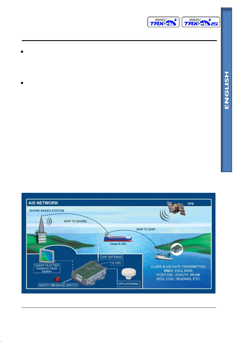
AIS stands for Automatic Identification System. AIS increases naviga-
tional safety and collision avoidance by transmitting vessel identifica-
tion, helping to reduce the difficulty of identifying ships when not in
sight (e.g. at night, in radar blind arcs or shadows or at distance) by
broadcasting navigational intentions to other vessels by providing ID,
position, course, speed and other ship data with all other nearby ships
and land based stations.
According to IALA regulations, AIS is defined as follows:
AIS is a broadcast Transponder system, operating in the VHF maritime
mobile band. It is capable of sending ship information such as identifica-
tion, position, course, speed and more, to other ships and to shore. It
can handle multiple reports at rapid update rates and uses Carrier Sense
Time Division Multiple Access (CSTDMA) technology to meet these high
broadcast rates and ensure reliable and robust ship to ship operation.
The IMO defines the performance standards as follows:
Ship to ship working, ship to shore working, including long range appli-
cation, automatic and continuous operation, provision of information
messaging via PC and utilization of maritime VHF channels
The Modules:
GPS system, AIS Transponder, VHF Antenna, and the Data Power Cable
and the appropriate application software.
AIS are required to function flawlessly in a variety of modes.
The relevant regulations requirements:
The system shall be capable of
An "autonomous and continuous" mode for operation in all areas.
This mode shall be capable of being switched to/from one of the fol-
lowing alternate modes by a competent authority;

Quick Instruction, Version 2.2 Page 9 of 43 pages
Weatherdock AG Sigmundstraße 180 90431 Nürnberg
Tel.:+49 911 37663835 www.weatherdock.de
An "assigned" mode for operation in an area subject to a compe-
tent authority responsible for traffic monitoring such that the data
transmission interval and/or time slots may be set remotely by that
authority;
A "polling or controlled" mode, where the data transfer occurs in
response to interrogation from a ship or competent authority.
This illustration depicts a typical AIS System, where two or more AIS
equipped vessels (and shore based systems) are automatically communi-
cating with each other.
The following sketch shows a typical easyTRX2 installation in a common
environment. The easyTRX2 is connected to the vessels power supply,
and in connection with the VHF, and GPS-Antennas, the minimal re-
quirements for Transponder operation are fulfilled.
Both vessels in this illustration are equipped with an AIS transceiver.
Due to “Time – Synchronization” they use the same organization of free
and allocated windows (Slots) in the shared VHF Data Link (this method
is called “Carrier Sense Time Division Multiple Access”) to send and re-
ceive messages. Without the necessity of any operating interaction, both

Quick Instruction, Version 2.2 Page 10 of 43 pages
Weatherdock AG Sigmundstraße 180 90431 Nürnberg
Tel.:+49 911 37663835 www.weatherdock.de
vessels know exactly who or what is cruising nearby and where the indi-
vidual object is heading.
1.2 What AIS classes do exist?
The scenario below shows a full AIS coverage area (including all applica-
tions and complete shore infrastructure).
There are two classes of AIS units fitted to vessels, Class A and Class B. In
addition AIS base stations may be employed by the Coastguard, port
authorities and other authorized bodies. AIS units acting as Aids to
Navigation (A to N) can also be fitted to fixed and floating navigation
markers such as channel markers and buoys.
1.2.1 Class A
Class A units are a mandatory fit under the safety of life at sea (SOLAS)
convention to vessels above 300 gross tons or which carry more than 11
passengers in International waters. Many other commercial vessels and
some leisure craft also may be fitted Class A units.
The Class A operation consists of three different types of messages:

Quick Instruction, Version 2.2 Page 11 of 43 pages
Weatherdock AG Sigmundstraße 180 90431 Nürnberg
Tel.:+49 911 37663835 www.weatherdock.de
Dynamic information:
MMSI number
position of the ship (derived from GPS)
time, when the position was measured in UTC
course over ground (COG)
speed over ground (SOG)
heading (HOG)
ship status
rotational speed/turn rate
Static information:
call sign and name of the vessel
length and width of the vessel
IMO-number of the vessel, if existent
type of vehicle
position of the GPS sensor onboard
Journey-related information:
draught of the vessel
type of cargo
port of destination and estimated time of arrival (ETA)
route plan, optional
The block of dynamic information is the most important block looking
for threatening collisions. Therefore this block of information is trans-
mitted in a compulsory way, depending on the vessels movement. The

Quick Instruction, Version 2.2 Page 12 of 43 pages
Weatherdock AG Sigmundstraße 180 90431 Nürnberg
Tel.:+49 911 37663835 www.weatherdock.de
following table shows the mandatory repetition rate of Class A transmis-
sions linked to the ship’s movement:
anchored vessels 3 minutes
vessels at 0 –14 kn 10 seconds
vessels at 0 –14 kn, fast maneuver 3.3 seconds
vessels at 14 –23 kn 6 seconds
vessels at 14 –23 kn, fast maneuver 2 seconds
vessels at > 23kn 2 seconds
vessels at > 23 kn, fast maneuver 2 seconds
Static information as well as information belonging to the journey is
dispersed every 6 minutes.
The reporting intervals correspond to both radio channels (161.975 MHz,
162.025 MHz) together.
1.2.2 Class B
Class B: EN62287, 2005: class B operation is described in the standard
EN62287, published in 2005.This document is obligatory for class B. Pag-
es 15 and 38 describe the operation:
Class B units are designed for fitting in vessels which do not fall into the
mandatory Class A fit category.
The easyTRX2 (-IS) is a Class B AIS unit
Reporting intervals are:
dynamic ship data:
boats at < 2 kn: 3 minutes

Quick Instruction, Version 2.2 Page 13 of 43 pages
Weatherdock AG Sigmundstraße 180 90431 Nürnberg
Tel.:+49 911 37663835 www.weatherdock.de
boats at > 2 kn: 30 seconds
static ship data (similar to class A): 6 minutes
These intervals are the standard operation modes.
Competent authorities, like base stations, can have influence on the
reporting intervals (as they do with class A as well). Interval timing can
be reduced down to 5 seconds in exceptional cases. There is no automat-
ism to change the 30sec/3min dynamic intervals by the ship itself.
Think about
The comparison is done only for dynamic data transmission, because
these datasets contain the relevant information to calculate a future
collision point in time and distance, as well as allow the threatened ships
to communicate (MMSI number is stringent part of dynamic data infor-
mation) by VHF. Additionally, 2 more facts concerning class B operation
need to be mentioned:
Unlike the class A service, which is using the SOTDMA method (self or-
ganized time division multiple access) with predefined timeslots (the
ship listens to the traffic and the information containing in all other
telegrams and defines its own raster of transmission timing, which is
then distributed to all other participants within the radio range) the
class B service is using a “listen-before-talk-method”. This means, that
before transmitting, a ship has to observe the radio channel, whether to
be allowed to transmit, if the channel is not occupied, or whether to
wait for a free time slot.
To avoid disturbance of the professional class A service in crowded
areas, higher-ranking authorities can switch off all class B transponder
activities, which will probably never happen, but it should be men-
tioned.
Above given information is not complete and should give only an over-
view about the AIS topic. For more details please have a look to the
following links:
US Coast Guard –http://www.navcen.uscg.gov/enav/ais/default.htm

Quick Instruction, Version 2.2 Page 14 of 43 pages
Weatherdock AG Sigmundstraße 180 90431 Nürnberg
Tel.:+49 911 37663835 www.weatherdock.de
IMO –www.imo.com
http://www.aislive.com
2. SCOPE OF DELIVERY
In the carton there is contained:
The easyTRX2 (-IS)
The cable for the easyTRX2 (-IS) incl. separate USB cable
This manual for the operation of the easyTRX2 (-IS)
The installation CD for the configuration software
3. MOUNTING AND INSTALLATION
3.1 Programming Procedure
Installation of the PC software for programming boat specific data
oConnection of the easyTRX2 (-IS) by means of the supplied ca-
ble to the USB port of the PC
oTHEN, connect the easyTRX2 (-IS) to the power, not before!
To use this program for configuring your easyTRX2 (-IS) , the “easyTRX2
Programming tool” must be installed to your PC.
Insert the installation CD.
When the installation does not start automatically, locate the file
“setup.exe” on the CD-ROM drive and double click on this file to
start the installation process.
Follow the screen prompts
Start the easyTRX2 (-IS) programming software to configure ship
data (enter the MMSI carefully). It’s the only time you’ll need the
programming software.
Please fill out all necessary data.

Quick Instruction, Version 2.2 Page 15 of 43 pages
Weatherdock AG Sigmundstraße 180 90431 Nürnberg
Tel.:+49 911 37663835 www.weatherdock.de
As vessel type you should select type 37 for a pleasure boat.
Enter the vessel’s information in the appropriate fields:
MMSI number: enter the vessel's Maritime Mobile Service Identity
number (9 digits)
This is an official number like a license plate at a car. Misuse will be
punished very hard in different countries. Please be aware of that.
If the MMSI is not entered, the easyTRX2 won´t send any telegram.
When connecting the easyTRX 2 for the first time, the MMSI is not
defined (i.e. "000000000").
CAUTION:
For security reasons the MMSI of the vessel cannot be changed once
it has been programmed. Do not program the MMSI unless you are
certain you have the correct information. Please check the entered
number carefully. If the programmed MMSI is incorrect the AIS trans-
ponder will need to be returned to the supplier for factory reset.

Quick Instruction, Version 2.2 Page 16 of 43 pages
Weatherdock AG Sigmundstraße 180 90431 Nürnberg
Tel.:+49 911 37663835 www.weatherdock.de
Ship's name: enter the name of the vessel (20 characters maxi-
mum)
Call Sign: enter the vessel's radio call sign (7 characters maximum)
Select the most appropriate vessel type from the drop-down list.
For a pleasure craft (sailing and/or engine) it is 37.
Enter the vessel’s dimensions by defining the position of the GPS
antenna (see the sketch above, all dimensions are in meter):
oDimension A: distance from the GPS antenna location to the
bow
oDimension B: distance from the GPS antenna location to the
stern
oDimension C: distance from the GPS antenna location to the
port side
oDimension D: distance from the GPS antenna location to the
starboard side
Select the appropriate baud rate for your PC or chart plotter de-
vice (by default it is set to 38400 baud).
CAUTION:
If the easyTRX2 is set to 4800 Baud transfer rate, in high traffic areas it
might be the possibility of missing some AIS position reports of other
vessels.
The reason for that is the slower data throughput because of the data
rate.
Weatherdock does not take any responsibility for a full and reliable re-
ception of all AIS data around, if the RS422 baud rate is set to 4800
baud.
3.2 Diagnostics
If you select the tab “Diagnostics” you’ll get lot of information concern-
ing the status quo of the easyTRX2 (-IS).

Quick Instruction, Version 2.2 Page 17 of 43 pages
Weatherdock AG Sigmundstraße 180 90431 Nürnberg
Tel.:+49 911 37663835 www.weatherdock.de
“TRX status” gives you information about:
Valid MMSI:
Ok is only given when a correct MMSI was entered. Status OK is
condition for transmitting data.
GPS position fixed:
If your GPS is proper working, status OK is given
GPS Error:
Value is always >10 m. Used as a hint.
Satellites in view / used:
Number of received satellites / Number of satellites used for posi-
tion fix
Transmitter:
When the easyTRX2 (-IS) has send data for the first time, the status
changes from standby to OK. If there is any fault, ERROR is dis-
played and the device has to be repaired (red Error-LED is on).

Quick Instruction, Version 2.2 Page 18 of 43 pages
Weatherdock AG Sigmundstraße 180 90431 Nürnberg
Tel.:+49 911 37663835 www.weatherdock.de
Receiver:
When the easyTRX2 (-IS) has received AIS data for the first time, the
status changes from standby to OK. If there is any fault, ERROR is
signaled and the device has to be repaired (Error-LED is on).
Hardware status displays the power situation of the device. Important is
“Supply Voltage TX” which means the voltage level during transmission.
Here the easyTRX2 (-IS) is drawing 2A. If cables are too thin and very
long, the voltage may drop down below the “Idle-level”. If the drop
down is more than 1V, you may use cables with larger copper diameter.
Value RSSI1 and RSSI2 give information, if there are any interferer on the
AIS frequencies, which may be caused by a faulty electrical device. If
there is none, the status will be OK.
TX Forward Power and TX Reverse Power are OK if the connected VHF
antenna is proper working. If not, ERROR is displayed and the red LED is
on.
If the self diagnostic of the easyTRX2 (-IS) noticed any fault, a sort notice
will be given in the tables. The easyTRX2 (-IS) executes a self test every
30 sec. So each fault or warning report has got a countdown of 1 min.
This means the report disappears from the table, when the fault is no
longer valid after 1 min.
3.3 AIS transmitting data
The tab “Send Data” gives information about the latest send AIS data of
the own vessel. There is on one hand the “position report” (AIS message
No. 18), which transmits MMSI, position, speed and bearing. It is also
shown how much time elapsed since latest transmission depending to
your speed: 1min if speed is <2kn or 30 sec is speed is faster than 2 kn.
On the other hand there is the “static data report” (AIS message No. 24)
which includes MMSI, Ships name, call sign, ships dimensions and vessel
type. This message will be send every 6 min.

Quick Instruction, Version 2.2 Page 19 of 43 pages
Weatherdock AG Sigmundstraße 180 90431 Nürnberg
Tel.:+49 911 37663835 www.weatherdock.de
3.4 AIS receiving data
On the tab “Received Data” you can see a list of current received AIS
data. By using the drop down menu “data columns” you can blank out
columns.
Because the static data report is send every 6 min you have to wait for
at least 15 min to see ship names referring to the listed AIS data. If AIS
targets are too far away, it might take even more time of receiving the
complete data or of receiving nothing, because the vessel has disap-
peared.

Quick Instruction, Version 2.2 Page 20 of 43 pages
Weatherdock AG Sigmundstraße 180 90431 Nürnberg
Tel.:+49 911 37663835 www.weatherdock.de
3.5 SD Card Recorder
The tab “SD Card” shows the status quo of the SD recording. “Ready for
logging” is given if a well formatted SD Card is inserted.
The easyTRX2 (-IS) is using the FAT format. If the SD Card has got anoth-
er format, you have to format it again with the easyTRX2 (-IS). It’s be-
cause the device is storing a special set of files, which enable real time
storing of AIS and GPS data.
If the status is “broken” or invalid format” you have to format the SD
Card once again with the easyTRX2 (-IS). All stored data on it will be
erased.
Being formatted with the easyTRX2 (-IS) you can remove the SD Card at
any time without losing any data. In case of power loss the latest re-
ceived data will be kept on the SD Card.
With your easyTRX2 you get the possibility of recording data to the SD-
Card. All Data from the NMEA0183 and the USB will be recorded.
Other manuals for easyTRX2 S series
2
This manual suits for next models
3
Table of contents
Other Weatherdock Marine Radio manuals