ADVANSEA T-50 User manual

C.56 / T.56 / T.50
USER MANUAL
English version
Other languages available on the C -Rom or at:
www.advansea.com
C.56 / T.56 / T.50 USER MANUAL – Ref. 58108 – MARCH 2009 – Rev. 1

Installation and Operation Manual
2
Industry Canada
Operati n is subject t the f ll wing tw c nditi ns: (1) this device may n t cause interference,
and (2) this device must accept any interference, including interference that may cause undesired
perati n f the device.
FCC Statement
N te: This equipment has been tested and f und t c mply with the limits f r a Class B digital
device, pursuant t Part 15 f the FCC Rules. These limits are designed t pr vide reas nable
pr tecti n against harmful interference in a n rmal installati n. This equipment generates uses
and can radiate radi frequency energy and, if n t installed and used in acc rdance with the
instructi ns, may cause harmful interference t radi c mmunicati ns. H wever, there is n
guarantee that interference will n t ccur in a particular installati n. If this equipment d es cause
harmful interference t radi r televisi n recepti n, which can be determined by turning the
equipment ff and n, the user is enc uraged t try t c rrect the interference by ne r m re f
the f ll wing measures:
1- Re rient r rel cate the receiving antenna
2- Increase the separati n between the equipment and receiver
3- C nnect the equipment int an utput n a circuit different fr m that t which the
receiver is c nnected
4- C nsult the dealer r an experienced technician f r help
5- A shielded cable must be used when c nnecting a peripheral t the serial p rts
Important
It is the wner’s s le resp nsibility t install and use the unit in a manner that will n t cause
accidents, pers nal injury r pr perty damage. The user f this pr duct is s lely resp nsible f r
bserving safe b ating practices.
Global Positioning System: The Gl bal P siti ning System (GPS) is perated by the US
g vernment which is s lely resp nsible f r its perati n, accuracy and maintenance. The GPS
system is subject t changes which c uld affect the accuracy and perf rmance f all GPS
equipment anywhere in the w rld.
Installation: If installati n is n t c rrect, the unit can n t perf rm at its designed p tential. If in
d ubt, c nsult y ur Advansea dealer. Ensure that any h les made are in a safe p siti n and will
n t weaken the b at’s structure. If in d ubt, c nsult a qualified b at builder.
PLASTIMO DISCLAIMS ALL LIABILITY FOR ANY USE OF THIS PRODUCT IN A WAY THAT MAY
CAUSE ACCIDENTS, DAMAGE OR THAT MAY VIOLATE THE LAW.
Governing language: This statement, any instructi n manuals, user guides and ther
inf rmati n relating t the pr duct (d cumentati n) may be translated t , r has been translated
fr m, an ther language (translati n). In the event f any c nflict between any translati ns f the
d cumentati n, the English language versi n f the d cumentati n will be the fficial versi n f
the d cumentati n. This manual represents the installati n pr cedures as at the time f printing.
AdvanSea reserves the right t make changes t specificati ns with ut n tice.
C pyright © 2009 Plastim , France, all rights reserved. Advansea
TM
is a registered trademark f
Plastim .
Presentation
Thank y u f r having purchased an Advansea pr duct. This handb k c ntains an explanati n f
h w t install, perate and maintain y ur Advansea unit.

Installation and Operation Manual
3
SAFETY INSTRUCTIONS
Electr nic charts displayed by the chart pl tter are believed t be
accurate and reliable, but they are n t intended t replace fficial
charts which sh uld remain y ur main reference f r all the matters
related t the executi n f a safe navigati n. F r this reas n we w uld like t
remind y u that y u are required t carry n b ard and use the fficially published
and appr ved nautical chart.
Please read thr ugh this manual bef re the first perati n. If y u have any
questi ns, please c ntact the cust mer service r y ur l cal dealer r distribut r
Extensive exp sure t heat may result in damage t the chart pl tter.
C nnecti n t the p wer s urce with reversed p larity will damage the chart
pl tter severely. This damage is n t c vered by the warranty.
D n t disassemble. The chart pl tter c ntains danger us high v ltage circuits
which nly experienced technicians must handle
Exp sure f the display t UV rays may sh rten the life f the liquid crystals used
in y u pl tter. This limitati n is due t the current techn l gy f the LCD display.
Av id verheating which may cause l ss f c ntrast and, in extreme case, a
darkening f the screen. Pr blems which ccur fr m ver heating are reversible
when temperature decreases.
Screen Cleaning Precautions
Cleaning y ur chart pl tter screen is a very imp rtant perati n and must be d ne
carefully. The f ll wing is the cleaning pr cedure.
Y u use a tissue r lens tissue and a cleaning spray c ntaining ls pr pan l (a
n rmal spray cleaner s ld f r PC screens. F ld the tissue r lens tissue int a
triangular shape, m isten the tip and use the index finger behind a c rner t
m ve the tissue acr ss the surface, in verlapping side t side str kes. If the
tissue is t wet, a n ticeable wet film will be left in its path and y u will need t
repeat the pr cess. If t dry, the tissue w n’t glide easily, and may damage the
surface.
If y u require technical advice r assistance, c ntact y ur nearest Plastim ffice r
visit ur website, www.advansea.c m.

Installation and Operation Manual
4
1 Introduction
1-1 General Inf rmati n ................................................................................... 7
1-2 Specificati n.............................................................................................. 7
1-3 Packing List ..............................................................................................10
1-4 Opti nal Access ries..................................................................................10
2 Getting Started
2-1 M unting the Unit .....................................................................................11
2-1-1 Bracket M unting .................................................................................................... 11
2-1-2 Flush M unting ....................................................................................................... 11
2-2 Keys ........................................................................................................12
2-3 C-MAP MAX Secure Digital (SD) Card ..........................................................13
2-4 Simulate M de..........................................................................................13
2-5 Data Bar ..................................................................................................13
2-6 C mpass ..................................................................................................14
2-7 Multi wind w displays................................................................................15
2-8 Man verb ard (MOB) ...............................................................................17
3 General Operation
3-1 Manual / Aut P wer n and ff .................................................................18
3-2 Brightness, night m de and Backgr und......................................................18
3-3 The main wind w......................................................................................19
3-4 Chart .......................................................................................................21
3-4-1 Chart wind w.......................................................................................................... 21
3-4-2 Perspective view...................................................................................................... 21
3-4-3 Latitude and l ngitude............................................................................................. 22
3-4-4 Chart scale.............................................................................................................. 22
3-4-5 Finding a chart symb l............................................................................................. 22
3-4-6 Chart symb ls and inf rmati n................................................................................. 23
3-4-7 Intr ducti n t navigating........................................................................................ 23
3-4-8 G ing t a wayp int r t a p int n the chart .......................................................... 23
3-4-9 F ll wing a r ute..................................................................................................... 24
3-4-10 G t Key............................................................................................................... 24
3-4-11 Distance and bearing calculat r.............................................................................. 25
3-4-12 Pr jected c urse.................................................................................................... 25
3-5 S nar : C mbine intr ducti n and Wind ws in ne chapter ...........................26
3-5-1 Interpreting the display ........................................................................................... 26
3-5-2 M de...................................................................................................................... 26
3-5-3 Single and Dual frequency fish finding...................................................................... 27
3-5-4 Range..................................................................................................................... 27
3-5-5 Gain ....................................................................................................................... 28
3-5-6 S nar wind w display.............................................................................................. 29
3-5-7 N split................................................................................................................... 29
3-5-8 Split Z m and Full Screen Z m ............................................................................. 30
3-5-9 Split b tt m ............................................................................................................ 30
3-5-10 Split 50/200 .......................................................................................................... 31
3-5-11 Split A-Sc pe......................................................................................................... 31
3-6 Highway...................................................................................................32
3-7 Gauges ....................................................................................................32
3-8 Wayp ints ................................................................................................33

Installation and Operation Manual
5
3-8-1 Creating a new wayp int ......................................................................................... 33
3-8-2 M ving a wayp int .................................................................................................. 33
3-8-3 Editing an existing wayp int..................................................................................... 33
3-8-4 Deleting a wayp int................................................................................................. 34
3-8-5 Find a wayp int....................................................................................................... 34
3-8-6 S rt Wayp ints........................................................................................................ 34
3-8-7 Deleting all wayp ints.............................................................................................. 34
3-9 R utes .....................................................................................................35
3-9-1 Managing a r ute fr m the chart wind w.................................................................. 35
3-9-2 Managing a r ute fr m the r ute wind w ................................................................. 36
3-10 Satellites ................................................................................................37
3-10-1 Satellite inf rmati n............................................................................................... 37
3-11 Tides......................................................................................................38
3-12 AIS ........................................................................................................39
3-12-1 Viewing AIS Vessels............................................................................................... 39
3-12-2 AIS Wind ws......................................................................................................... 39
3-13 DSC .......................................................................................................40
3-13-1 distress................................................................................................................. 41
3-13-2 P ll ....................................................................................................................... 42
3-14 Navtex ...................................................................................................43
3-15 Engine Faults ..........................................................................................43
4 Advance Settings
4-1 System C nfigurati n Settings....................................................................44
4-1-1 Language................................................................................................................ 44
4-1-2 Beep v lume........................................................................................................... 44
4-1-3 Aut p wer ............................................................................................................. 44
4-1-4 Features ................................................................................................................. 44
4-1-5 Fact ry reset........................................................................................................... 44
4-1-6 Ab ut ..................................................................................................................... 44
4-2 Chart Settings...........................................................................................45
4-2-1 R tati n.................................................................................................................. 45
4-2-2 Palette.................................................................................................................... 45
4-2-3 General................................................................................................................... 45
4-2-4 Land & Sea ............................................................................................................. 46
4-2-5 Map datum ............................................................................................................. 46
4-2-6 NMEA datum ffset.................................................................................................. 46
4-2-7 Map shift ................................................................................................................ 46
4-2-8 Rest re default........................................................................................................ 46
4-3 S nar Settings ..........................................................................................47
4-3-1 Frequency............................................................................................................... 47
4-3-2 Palette.................................................................................................................... 47
4-3-3 Scr ll speed ............................................................................................................ 47
4-3-4 Digit size................................................................................................................. 47
4-3-5 Fish ........................................................................................................................ 47
4-3-6 Advance Settings..................................................................................................... 47
4-3-7 Rest re default........................................................................................................ 47
4-4 GPS Settings.............................................................................................48
4-4-1 GPS S urce............................................................................................................. 48
4-4-2 DGPS S urce........................................................................................................... 48
4-4-3 Static Navigati n ..................................................................................................... 48

Installation and Operation Manual
6
4-4-4 Speed Filter and C urse Filter .................................................................................. 48
4-4-5 Lat/L n d.p’s........................................................................................................... 48
4-4-6 Ship speed.............................................................................................................. 48
4-4-7 Magnetic Variati n................................................................................................... 48
4-5 Track & L g Settings .................................................................................49
4-5-1 Track ...................................................................................................................... 49
4-5-2 L gs ....................................................................................................................... 49
4-6 Mem ry Settings .......................................................................................50
4-6-1 Select device........................................................................................................... 50
4-6-2 Save....................................................................................................................... 50
4-6-3 L ad....................................................................................................................... 50
4-6-4 Delete .................................................................................................................... 50
4-6-5 F rmat.................................................................................................................... 51
4-6-6 Screen snap sh t..................................................................................................... 51
4-7 AIS Settings..............................................................................................51
4-7-1 Display filter ........................................................................................................... 51
4-7-2 Alarm pti n ........................................................................................................... 52
4-7-3 Display pti ns........................................................................................................ 52
4-7-4 Rest re default........................................................................................................ 52
4-8 Alarms .....................................................................................................53
4-8-1 Fish ........................................................................................................................ 53
4-8-2 Deep ...................................................................................................................... 53
4-8-3 Shall w................................................................................................................... 53
4-8-4 Temperature ........................................................................................................... 53
4-8-5 Temperature rate..................................................................................................... 53
4-8-6 L w battery ............................................................................................................ 53
4-8-7 Navigati n alarms.................................................................................................... 53
4-8-8 AIS......................................................................................................................... 53
4-8-9 DGPS...................................................................................................................... 53
4-8-10 Rest re default...................................................................................................... 53
4-9 Others......................................................................................................54
4-9-1 Simulate ................................................................................................................. 54
4-9-2 Wayp int ................................................................................................................ 54
4-9-3 GPS........................................................................................................................ 54
4-9-4 Units ...................................................................................................................... 54
4-9-5 C mms ................................................................................................................... 54
4-9-6 Calibrate ................................................................................................................. 54
4-9-7 Time....................................................................................................................... 54
4-9-8 Rest re default........................................................................................................ 54
5 INSTALLATION
5-1 Opti ns and Access ries ............................................................................55
5-2 C nnecti ns .............................................................................................56
5-3 P wer/data cable ......................................................................................56
5-4 Alarm.......................................................................................................57
5-5 GPS antenna ............................................................................................57
5-5-1 Internal antenna ..................................................................................................... 57
5-5-2 External antenna..................................................................................................... 57
5-5-3 The antenna using NMEA......................................................................................... 58
5-6 NMEA 0183 ..............................................................................................58
5-7 NMEA 2000 ..............................................................................................59
5-8 S nar Transducers.....................................................................................60
5-9 Setup and test ..........................................................................................61

Installation and Operation Manual
7
1-1 General Information
The AdvanSea chart pl tter is a precisi n-
crafted GPS chart Pl tter with high-
perf rmance receiver f r the Gl bal
P siti ning System c nstellati n f satellites,
pr viding precise l cati n data with a h st f
navigati n features. S me functi ns require
pti nal units and sens rs installed n y ur
b at.
The AdvanSea chart pl tter can be c nnected
t external devices with NMEA0183 and
NMEA2000 interface and display inf rmati n.
F ll wing are the examples.
• NAVTEX
• AIS receiver
• DSC VHF radi
• Transducer & sens rs
• Aut pil t
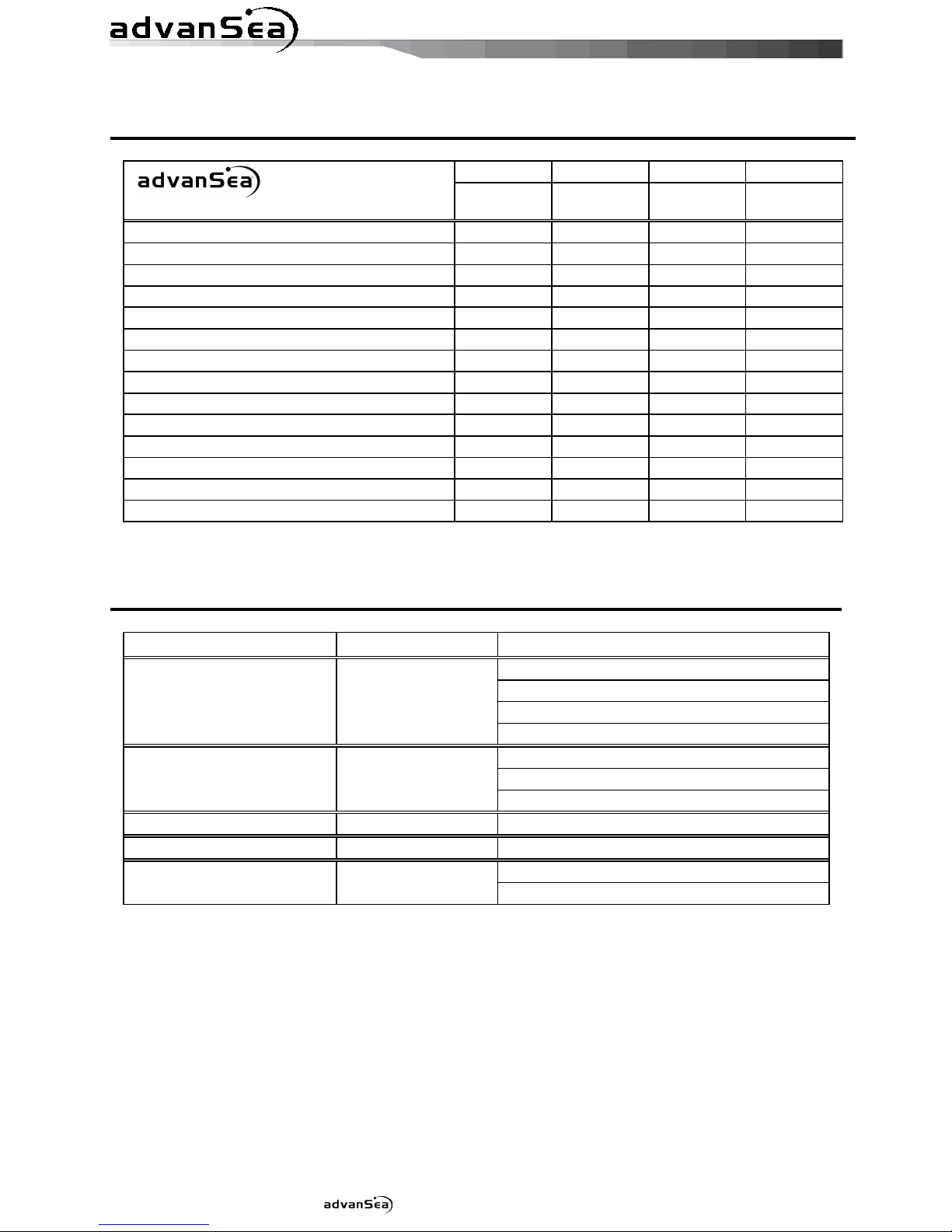
1-2 Specification
[AdvanSea T.50]
GENERAL
Category etail
Size 172.5 mm(H) x 157.5 mm(W) x 75 mm(D)
isplay 5” diag nal, TFT c l r, 240 x 320 pixels.
Supply voltage 10 t 34 V DC
Supply current 13.8 V
320 mA min - n backlighting.
530 mA max - full backlighting.
External beeper or light
output
Switched t gr und t s und alarm, 30V DC, 200 mA maxmum
Operating temperature -10° t 50°C
ALARMS
User set: Arrival radius, anch r, XTE, danger, t shall w, t deep, temperature, temperature rate, l w
battery, l ss f DGPS fix, danger us AIS vessels.
GPS NAVIGATION
Chart card C-MAP™ SD Card (NT-MAX, NT+ r NT)
User card SD Card
Waypoints Up t 5000, with default r user defined alphanumeric names up t
eight characters.
Routes 100 R utes, with up t 100 p ints each
Tracks By time r distance, 10 track f 5000 p ints
Chart datums 216 Chart datums
One user-defined map shift.
Chart scale 0.2 t 500 nm f r chart (chart dependent) d wn t 0.005 nm in pl tter
m de.
COMMUNICATIONS
NMEA NMEA 0183 4800, 9600, 38400 baud
NMEA 0183 Inputs from
compatible instruments
DBK, DBS, DBT, DPT, GGA, GLL, GNS, GGA, GSV, HDG, HDT, MDA,
MTA, MTW, MWD, MWV, RMC, RPM, VHW, VTG, VWT, ZDA
NMEA 0183 Outputs, for
compatible instruments
APA, APB, BWR, GGA, GLL, GSA, GSV, RMB, RMC, VTG, XTE, DBT,
DPT, MTW, VHW, XDR
1 Introduction

Installation and Operation Manual
8
[AdvanSea T.56]
GENERAL
Category etail
Size 172.5 mm(H) x 157.5 mm(W) x 75 mm(D)
isplay 5.6” diag nal, TFT c l r, 480 x 640 pixels.
Supply voltage 10 t 34 V DC
Supply current 13.8 V
350 mA min - n backlighting.
480 mA max - full backlighting.
External beeper or light
output
Switched t gr und t s und alarm, 30V DC, 200 mA maxmum
Operating temperature -10° t 50°C
ALARMS
User set: Arrival radius, anch r, XTE, danger, t shall w, t deep, temperature, temperature rate, l w
battery, l ss f DGPS fix, danger us AIS vessels.
GPS NAVIGATION
Chart card C-MAP™ SD Card (NT-MAX, NT+ r NT)
User card SD Card
Waypoints Up t 5000, with default r user defined alphanumeric names up t
eight characters.
Routes 100 R utes, with up t 100 p ints each
Tracks By time r distance, 10 track f 5000 p ints
Chart datums 216 Chart datums
One user-defined map shift.
Chart scale 0.2 t 500 nm f r chart (chart dependent) d wn t 0.005 nm in pl tter
m de.
COMMUNICATIONS
NMEA NMEA 0183 4800, 9600, 38400 baud
NMEA 2000
NMEA 0183 Inputs from
compatible instruments
DBK, DBS, DBT, DPT, GGA, GLL, GNS, GGA, GSV, HDG, HDT, MDA,
MTA, MTW, MWD, MWV, RMC, RPM, VHW, VTG, VWT, ZDA
NMEA 2000 Inputs from
compatible instruments
System date and time(PGN126992),Vessel
Heading(PGN127250),Engine parameters/Rapid Update(PGN127488),
Engine parameters/Dynamic(PGN127489),Trip
parameters/Engine(PGN127497),Engine
parameters/Static(PGN127498),Fluid level(PGN127505),Water
Speed(PGN128259),Water depth(PGN128267),P siti n/Rapid
Update(PGN129025),COG & SOG/Rapid Update(PGN129026),GNSS
P siti n Data(PGN129029),GNSS DOPs(PGN129539),GNSS Sats in
View(PGN129540),Wind Data(PGN130306),Envir nmental Parameter-
Water temp(PGN130310),Envir nmental Parameter(PGN130311)
NMEA 0183 Outputs, for
compatible instruments
APA, APB, BWR, GGA, GLL, GSA, GSV, RMB, RMC, VTG, XTE, DBT,
DPT, MTW, VHW, XDR
NMEA 2000 Outputs, for
compatible instruments
Water Speed(128259), Water depth(128267), XTE(129283), NAV.
data(129284), NAV. data(129285), COG & SOG(129026), GNSS
p siti n(129029), Water temp.(130310)

Installation and Operation Manual
9
[AdvanSea C.56]
GENERAL
Category etail
Size 172.5 mm(H) x 157.5 mm(W) x 75 mm(D)
isplay 5.6” diag nal, TFT c l r, 480 x 640 pixels.
Supply voltage 10 t 34 V DC
Supply current 13.8 V
800mA min - n backlighting.
1000mA max - full backlighting.
External beeper or light
output
Switched t gr und t s und alarm, 30V DC, 200 mA maxmum
Operating temperature -10° t 50°C
ALARMS
User set: Arrival radius, anch r, XTE, danger, t shall w, t deep, fish, temperature, temperature rate,
l w battery, l ss f DGPS fix, danger us AIS vessels.
GPS NAVIGATION
Chart card C-MAP™ SD Card (NT-MAX, NT+ r NT)
User card SD Card
Waypoints Up t 5000, with default r user defined alphanumeric names up t
eight characters.
Routes 100 R utes, with up t 100 p ints each
Tracks By time r distance, 10 track f 5000 p ints
Chart datums 216 Chart datums
One user-defined map shift.
Chart scale 0.2 t 500 nm f r chart (chart dependent) d wn t 0.005 nm in pl tter
m de.
COMMUNICATIONS
NMEA NMEA 0183 4800, 9600, 38400 baud
NMEA 2000
NMEA 0183 Inputs from
compatible instruments
DBK, DBS, DBT, DPT, GGA, GLL, GNS, GGA, GSV, HDG, HDT, MDA,
MTA, MTW, MWD, MWV, RMC, RPM, VHW, VTG, VWT, ZDA
NMEA 2000 Inputs from
compatible instruments
System date and time(PGN126992),Vessel
Heading(PGN127250),Engine parameters/Rapid Update(PGN127488),
Engine parameters/Dynamic(PGN127489),Trip
parameters/Engine(PGN127497),Engine
parameters/Static(PGN127498),Fluid level(PGN127505),Water
Speed(PGN128259),Water depth(PGN128267),P siti n/Rapid
Update(PGN129025),COG & SOG/Rapid Update(PGN129026),GNSS
P siti n Data(PGN129029),GNSS DOPs(PGN129539),GNSS Sats in
View(PGN129540),Wind Data(PGN130306),Envir nmental Parameter-
Water temp(PGN130310),Envir nmental Parameter(PGN130311)
NMEA 0183 Outputs, for
compatible instruments
APA, APB, BWR, GGA, GLL, GSA, GSV, RMB, RMC, VTG, XTE, DBT,
DPT, MTW, VHW, XDR
NMEA 2000 Outputs, for
compatible instruments
Water Speed(128259), Water depth(128267), XTE(129283), NAV.
data(129284), NAV. data(129285), COG & SOG(129026), GNSS
p siti n(129029), Water temp.(130310)
SONAR FISHFIN ING
epth range 0 m t 600 m
Sonar output P wer: Variable, up t 600 W RMS
Dual frequency: 50 khz and 200 kHz
Temperature Range 0° t 37.7°C (32°F t 99.9°F)
Res luti n f 0.1° unit.
Speed (fr m paddlewheel
transducer)
1 t 96.6 kph (57.5 mph, 50 kn).
Installation and Operation Manual
10
1-3 Packing List
Model T.50 T.56 C.56 C.56
Item List Part number 57736
57738
57740
57741
isplay Ο Ο
Ο
Ο
Bracket Ο Ο
Ο
Ο
Cover Ο Ο
Ο
Ο
Power Cable Ο Ο
Ο
Ο
Bracket mounting screw Ο Ο
Ο
Ο
Flush mount Kit (Including screw) Ο Ο
Ο
Ο
Protection Cover Ο Ο
Ο
Ο
User’s Manual(Eng) Ο Ο
Ο
Ο
C -ROM(Multi-language) Ο Ο
Ο
Ο
Quick Reference (Multi language) Ο Ο
Ο
Ο
Warranty Ο Ο
Ο
Ο
Cable tie Ο Ο
Ο
Ο
Y cable X X X Ο
P58 Transducer X X Ο Ο
1-4 Optional Accessories
Model Part number
Item List
GPS antenna + BNC Plug
GPS antenna supp rt
User’s Manual (Multilingual)
GPS Antenna +
GPS Antenna Support
57743
Warranty
GPS antenna + BNC Plug
User’s Manual (Multilingual)
GPS Antenna 57744
Warranty
GPS Antenna Support
57745 GPS antenna supp rt
5" & 5.6" Cover 57746 COVER
Bracket 5" & 5.6" Bracket 57747
Screws

Installation and Operation Manual
11
2-1 Mounting the Unit
The AdvanSea is supplied with patented quick release bracket. Y u can ch se a meth d f
installati n acc rding t y ur preference.
2-1-1 Bracket Mounting
Bef re installing ensure the area the bracket is m unted t is str ng en ugh t supp rt the
weight f the GPS chart pl tter. After the l cati n is f und, attach the m unting base t the
area using the supplied hardware.
Mounting the display Unit:
1 H ld the display unit and find a gr ve
j int between the display unit and bracket.
2 Gently push the display unit int the
gr ve f bracket; push the display unit as
far as it can g .
Removing the display unit:
1 Turn the unit ff
2 Push the t p side f bracket ut.
3 Pull the display unit ut.
Note
The AdvanSea chart pl tter with internal GPS
antenna is designed t be bracket m unting and
flush m unting. H wever, if y u flush m unt inside f
y ur b at, GPS perf rmance can be reduced.
2-1-2 Flush Mounting
1 Find a l cati n f r flush m unting.
2 Drill a h le in the area f the cut ut area
f r the blade f jig saw.
3 insert and cut ut the area n the panel
using the jig saw
4 Drill f ur h les f r m unting studs.
5 Install the m unting studs n the chart
pl tter and insert them int the m unting
h le.
6 Attach the chart pl tter t the m unting
l cati n by attaching the supplied
hardware t the m unting studs.
Note
1 If y u flush m unt, y u need the pti nal external
GPS antenna.
2 Bef re Drilling h les make sure there is en ugh
space t m unt the chart pl tter there is n
bstructi ns.
2 Getting Started
Installation and Operation Manual
12
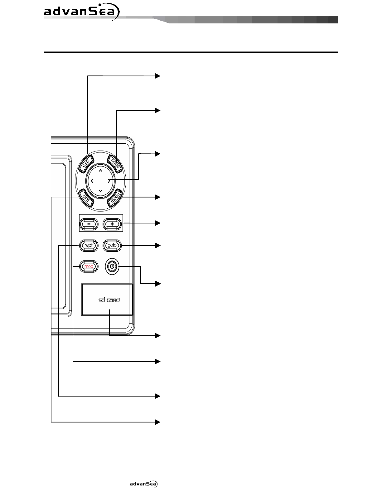
2-2 Keys
esc
– Exit fr m menu and return t previ us
menu r wind w. In chart wind w,
it
places wn ship at center.
page
–
Sh w main wind ws and all w y u t
setup displays as y u like.
c
ursor
– M ves the curs r n the display
screen. In s nar wind w, y u can
review s nar hist ry.
menu
– Access t setting menu - Sh w
available pti ns f current wind w.
-,
-
Z m in and z m ut t multiple chart
level
goto
- Start navigating t a destinati n p int
such as a MOB wayp int, wayp int.
power
– Turns p wer n/ ff. Opens display
Brightness, Night m de and
backgr und settings.
SD Card
– Open the c ver t install
SD card
mob
– Places a MOB wayp int n the chart
wind w under the b ats p siti n.
wpt
– Create a wayp int.
ent
–
Select the desired pti n r t c nfirm
selecti n

Installation and Operation Manual
13
2-3 C-MAP MAX Secure igital (S ) Card
This secti n pr vides instructi ns f r inserting and rem ving C-MAP MAX SD card pr cedure.
Inserting the S Card
1 H ld the SD card s that y u can
see the C-Map label.
2 Open the d r, gently push the SD card
int the sl t; push the SD card in as far as
y u hear click s und, then cl se d r.
Removing the S Card
1 Turn ff the unit.
2 Open the d r and push in n the SD card
until it is released.
3 Cl se the d r.
Insert C-MAP S card
correctly.
( O NOT FORCE)
Close S card door firmly all
the times.
o not remove S card
during reading and writing.
2-4 Simulate Mode
Simulate M de is great f r practicing the actual use f a pr duct when the satellites signals
and internal alarms are n t available. In the simulate m de, the unit turns the GPS receiver ff
and ign res data fr m all pti nal devices.
Tw simulate m des are available as bel w.
• Normal: All ws a user t practicing the
actual use f a pr duct with ut satellites
c nnecti n
• emo: b at travel al ne given r ute at
given speed and sh w different functi n f
the unit.
o not try to navigate in a
simulate mode. While the
simulate mode is turned on,
the GPS receiver is not
active.
2-5 ata Bar
Data bar displays useful navigati n
inf rmati n at the t p f the display.
isplaying ata bar
1 Press and select ata bar.
2 Select ata bar.

Installation and Operation Manual
14
Setting the data displayed in data bar
1 Press and select ata bar.
2 Select ata bar then ata bar setup.
3 M ve the curs r key t highlight the data
field y u want t change then press .
4 Select ata type.
5 Select a desired data y u want t display in
the field then press .
6 Repeat ab ve steps if necessary.
Selecting the ata bar size
1 Press and select ata bar.
2 Select ata bar then ata bar size.
3 Select the desired size f data bar.
[Large]
[Small]
Tip: If y u select N ne f r all data fields,
the data bar will disappear t save space f r
the chart.
Tip: Even th ugh y u setup a data bar
f r specific wind w, the data bar is n t apply
t all ther wind w.
2-6 Compass
The AdvanSea chart pl tter c mputes
c mpass directi n fr m the c nstellati n f
GPS satellites. F r the GPS chart pl tter t
c mpute directi n the vessel must be m ving
thr ugh the water.
F r easy reading and rec gniti n, there is a
c mpass needle at t p right side.
When the c mpass is displayed, COG is
always displayed in data field.
Als when y u are navigating t a p int, COG
and BRG is always displayed in data bar.
Tip
COG(C urse Over Gr und) – The c urse y u
vessel is heading.
BRG(Bearing) – The directi n fr m y ur
current p siti n t a destinati n p int.
T turn the c mpass ff r n:
1 Press and select ata bar.
2 Select Compass.

Installation and Operation Manual
15
2-7 Multi window displays
Adding a window
1 Press and select Add ic n.
2 Select an ic n y u want t add.
3 Repeat ab ve steps if necessary.
Tip: The AdvanSea Chart pl tter can
display up t f ur wind ws at the same time.
Changing window size
1 Press and select Split ic n n
b tt m.
2 Press
r t change the height f
the wind ws if there is nly tw wind ws. If
the unit is displaying m re that three
wind ws, press , ,
r
t
change the height f the wind ws.
eleting a window
1 Press and h ld
t select a wind w
y u want t delete.
2 Press and select Remove ic n t
rem ve.
Replacing two windows on the display
1 Press and h ld t active desired
wind w y u want t replace.
2 Press , select Replace ic n.
3 Select ic n y u want t display then press
.

Installation and Operation Manual
16
The active window
T distinguish an active wind w am ng wind ws, an range b rder indicates the active
wind w. T change the active wind w t the next wind w, press and h ld .
Favorite displays
The m st c mm nly used wind ws are called fav rite displays and up t six fav rite wind ws
can be saved. Als each fav rite display can have data bar and c mpass.
isplaying a favorite display
1 Press twice.
2 when ab ve wind w p ps up select a desire display y u want.
Adding a favorite display
1 Organize a wind w as y u want.
2 Press t sh w the main wind w.
3 Select Save ic n at the b tt m
4 Select an ic n where y u want t add y ur fav rite display. If y u add the new fav rite
display n existing fav rite display new display will verwrite the ld display.

Installation and Operation Manual
17
2-8 Man overboard (MOB)
During navigati n, the “MOB” feature
pr vides a ne-t uch meth d f st ring a
l cati n, such as p int where a crew member
fell verb ard. In this m de, the chart pl tter
places a MOB p int n the chart page and all
the navigati n data sh wn is related t
navigating back t this p int, all wing y u t
retrace y ur path t the MOB p int
efficiently.
MOB will not work if the
unit does not have a GPS
fix.
1 When y u press , a MOB wayp int is
created.
2 When
is pushed n t in the Chart
wind w, the screen aut matically is
changed t Chart wind w and MOB
wayp int is at the center f the chart.
3 If aut pil t is c nnected, the unit sets the
MOB wayp int t be the destinati n and
start t navigate.
This might result in a
sudden and dangerous turn.
Tip: Even th ugh navigati n t MOB
wayp int is canceled, the MOB wayp int is
n t be rem ved fr m the wayp int list. T
delete the MOB wayp int, y u need t delete
it manually.

Installation and Operation Manual
18
3-1 Manual / Auto Power on and off
Manual power on
Press
and h ld until the display sh ws
the start up page. When the Warning screen
appears, press t accept.
Manual power off
Press and h ld f r 5 sec nds. A c unter
timer appears n the screen, if y u release
the butt n bef re the c untd wn timer
reaches zer , the chart pl tter will remain On.
Auto power
If the unit is wired f r aut then:
• The unit turns n aut matically when y u
turn n the b at’s igniti n.
• Y u can n t turn ff the unit if the igniti n
is turned n.
• If Aut p wer ff is set, the unit turns ff
aut matically when y u turn ff the b at’s
igniti n.
• If Aut p wer ff is set, the unit will n t be
turned ff even th ugh the b at’s igniti n is
turned ff. T turn ff, y u need t turn ff
the unit manually.
3-2 Brightness, night mode and Background
Y u can change the screen setting f r the
display. T change settings, sh rtly press .
Brightness
T change the brightness, select
Brightness, and press
t dim r t
brighten.
Press
t return t the previ us
screen.
Night mode
The AdvanSea chart pl tter has
prepr grammed settings all wing y u t
cust mize the l k f the Chart wind w. The
default is daytime view. Select Night mood
depending n what m de the display is in at
the time f selecti n.
T change m de:
1 Highlight Night mode.
2 Press
r .
Tip: The screen will be difficult t read if
the chart pl tter is in night mood when the
sun is t bright
Background
Y u can Changes the backgr und c l r if
necessary. This selecti n is a pers nal
preference. Select the pti n that gives y u
the clearest viewing in y ur weather
c nditi ns and viewing angle.
3 General Operation

Installation and Operation Manual
19
3-3 The page window
Press
t sh w the page wind w and select a functi n ic n y u want t display.
Note
1 S me functi n ic ns require pti nal units and
c nnected sens rs.
2 If y u press ne m re time in the main
wind w, fav rite wind w is displayed.

Installation and Operation Manual
20
Chart S nar Highway
Data Wayp ints R utes
Satellite
Tides
AIS
DSC Navtex Engine Faults
Other manuals for T-50
1
This manual suits for next models
2
Other ADVANSEA GPS manuals


