Adventure Pilot iFLY GPS User manual

Copyright 2012 by Adventure Pilot, LLC. iFly GPS is a trademark used by Adventure Pilot, LLC. Version 7.5.2, Rev 092512
Owner’s Manual
by Adventure Pilot

2
Contents
Overview
Specifications ........................................................ 3
Features ................................................................ 3
Warnings ............................................................... 5
Unit Overview ....................................................... 6
Mounting on a Windscreen ............................ 7
Connecting to Power ....................................... 7
Powering On ................................................... 7
Updating your iFly GPS........................................ 8
Main Display ........................................................ 9
Using the Touch-Screen ...................................... 10
Panning ......................................................... 10
Activating Buttons ........................................ 10
Switching Sectionals .................................... 10
Markers ......................................................... 10
Main Menu ........................................................... 11
Possible Actions Menu ........................................ 11
Airport Information Screen ................................ 13
Find Nearest... Menu ..................................... 14
About Menu ................................................... 14
GPS Overview Screen .............................. 14
Flight Planning
Flight Planning Options ..................................... 15
Option 1: Create a point-to-point plan by
touching the screen ...................................... 16
Option 2: Find an airport by code or keyword ..17
Fly Direct To Screen .................................. 17
Option 3: Use the Flight Planner .................. 18
Option 4: Rubber-band route modification .. 20
Option 5: Vertical flight planning .................. 21
Checking Your Flight Plan’s Airspaces ............... 22
Settings
Units of Measure ................................................ 23
Map Settings ....................................................... 23
Screen Settings ................................................... 23
Instrument Settings ............................................ 24
Selecting Instruments Mode ........................ 24
Customizing Instruments .............................. 24
Custom Waypoints .............................................. 26
Custom Waypoints Form ............................... 26
Alerts
Alert Types ........................................................... 27
Collision Alerts .................................................... 27
Setting Collision Alert Thresholds ................ 27
More about Terrain Alerts ......................... 28
Managing Active Collision Alerts ................. 29
Airspace Alerts ................................................... 30
Setting Airspace Alerts .................................. 30
Customizing Airspace Display Modes ......... 30
Terrain Highlights ................................................ 31
Vertical Speed to Target Instrument .................. 31
Customizing Vertical Speed to Target Settings ..32
AHRS Alerts ......................................................... 32
Map Modes
Changing Map Modes ........................................ 33
Weather Mode .................................................... 34
ADS-B Live Weather ...................................... 34
Traffic Mode ......................................................... 35
Plates & Diagrams Mode ................................... 36
Instruments Panel ............................................... 37
Horizontal Situation Indicator ....................... 37
Extra Features
Using the Remote Control ................................. 38
Setting up the PDF Viewer ................................. 38
External Devices ................................................. 39
Sending GPS Info to External Devices ......... 39
Installing an External ADS-B Device ............ 39
Device Status ................................................. 40
Troubleshooting External Devices ........... 40
Additional Information
Frequently Asked Questions .............................. 41
FCC Information .................................................. 42
Warranty .............................................................. 43

3
Features
Interface
Extensive zoom levels from 2 to 100 NM per inch
Touch-n-drag scrolling, works even in turbulence
Single-touch zoom in/out
Center and auto-track with a single touch
View Charts button switches between bordering
sectionals at a single touch
Night Mode darkens and inverts colors at night
Plug-and-fly autopilot capability
Remote Control included for use in turbulent
situations
Macro-zoom for Vector Mode (1/3 mile)
Interactive Instruments Panel
Portrait or Landscape views
Compatible with attitude heading reference
system (AHRS) devices, such as Levil or Clarity
Spatial Awareness
Track your current position with pre-loaded FAA
published sectionals, charts, plates and more
Critical and important airspaces are highlighted
and shaded
Instantly reference distance and bearing to any
point on the chart with a single touch of the
screen
Find Airport button shows a list of the nearest
airports with immediate navigational aids such as
distance, turn, and ETE
Overview
Specifications
Dimensions ...................................................................................................................... 7.25 x 4.5 x 0.75 inches
Weight ..................................................................................................................................................12 ounces
Current ........................................................................................................................................... 600mA @ 12V
Power Input ..................................................................................................................................... DC 12V~28V
GPS ................................................................................................................................................. SiRF Star – III
Operating Temperature ...........................................................................................14°F to 140°F (-10°C to 60°C)
Storage Temperature ...............................................................................................-4°F to 176°F (-20°C to 80°C)
Specifications are subject to change and improvement without notice. Actual product may vary from the images found in this document.
Distance rings around your current position
FAA published TFRs on all sectionals and charts
Vertical guidance to a target airport’s pattern
altitude using Vertical Speed to Target (VST)
instruments
Live weather data available through ADS-B via
third party devices; live updates of NexRad,
METARs, TAFs, Winds Aloft, and PIREPs
Pre-flight weather downloads for METAR, TAFs,
and Winds Aloft
Terrain/obstruction highlights in relative view and
profile view
Active alert messaging for terrain, airspace, and
collision
FAA Charts
Includes all sectionals, low enroute charts, WAC
charts, approach and departure plates
Explore charts with touch-sensitive panning and
zooming
Reference actual FAA airport taxi diagrams;
includes alpha-numerics for cutoffs and parallels
History button toggles between charts, previously
viewed airport details, and plates
Sectionals and plates include all of the “Border”
and “Legend” data as shown on FAA charts
Simple update process at www.iflyGPS.com

444
Overview
Flight Planning
Direct-to flight planning
Easily create multi-leg flight plans directly from
the sectional or flight planner
Rubber-band route line modifications (touch and
drag a route line to bend it around an airspace)
Vertical speed to target for custom waypoints
with specific altitudes (a 3-D flight plan)
Save/load/reverse flight plans
Flight plan is automatically saved and restored
between power cycles
Search for airports by code, airport name, or city
name
Vertical Flight Planning – plan or view the flight
plan from a defined altitude
Single string waypoint entry (e.g. KDFW KTKI
KSTL KOSH)
Data Updates
Unlimited updates from any internet-connected
computer (with a low-cost annual data
subscription)
Update with a USB flash drive or wireless
download via iFly Connect. (Note: Wi-Fi
updating available on the iFly 720.)
Prior to your flight, quickly update the latest
TFR, Metar, TAFs, Winds Aloft, and a GPS-
enabled graphical VFR/IFR reference map with
touch weather reports
Download software updates at
www.iflyGPS.com to always have the latest
new features
Airport Information
Geographical data and obstructions
Public and private airports
Attendance schedule
Communication information
Full runway information, including a thumbnail
with quick reference numbers
Traffic patterns with pattern altitude (if
published)
Georeferenced FAA Airport Diagrams for over
800 complex airports
Available IFR equipment
Additional FAA remarks
Compatible Devices
Digital Auto-Pilots
Dynon
TruTrak
Other Digital NMEA supported models
AHRS Units
Levil
Clarity SV
And more
ADS-B Receivers
Clarity (models with or without the SV
option)
LEVIL
SkyRadar
NavWorx
FreeFlight
Actively developing more
External serial GPS receiver input (Note: does
not use ADSB GPS)
Various EFIS and Fuel Flow Computers
Notes
Avoid using any chemical or abrasive cleaners
on the touchscreen and/or plastic casing. Clean
the touchscreen with a soft, clean, lint-free
cloth. Use water, isopropyl alcohol, or eyeglass
cleaner, if needed.
The iFly GPS does not contain any user-
serviceable parts. Repairs should only be made
by an authorized service center. Unauthorized
repairs or modifications could void both the
warranty and the pilot’s authority to operate
this device under FAA/FCC regulations.
All visual depictions contained within this
document, including screen images, are subject
to change and may not reflect the most current
iFly GPS receiver. Depictions may differ slightly
from the actual unit.
Use of polarized eye wear may cause the flight
displays to appear dim or blank.
Only use the power adapters provided with the
iFly GPS or recommended by Adventure Pilot
LLC.
Do not leave the iFly GPS in extremely high
or low temperatures. Do not use in a humid
environment or submerge in water.
Do not place near magnets or large speakers.
Do not put gold, metallic objects, or electric
wave emitting objects around the iFly GPS.

555
Overview
w Warnings w
wCarefully review this Owner’s Manual and make sure you thoroughly understand iFly GPS’s functionality and
operation before attempting to use the unit during actual flight.
wDo not install the iFly GPS where it obstructs the pilot’s field of view or interferes with operating controls.
wThe flight indicators shown on the iFly GPS are based on GPS-derived data and may differ from the aircraft’s
instruments.
wThe altitude shown on the iFly GPS is geometric height above Mean Sea Level and may differ from the
altitude displayed by pressure altimeters. Always use the pressure altitude displayed by your aircraft’s
altimeter for determining aircraft altitude.
wThis device is intended to supplement other navigation data sources and should be considered only as an aid
to enhance situational awareness. This device is not intended for use as a primary reference for navigation
or obstacle/terrain avoidance. It is the pilot’s sole responsibility to be aware of aircraft and surrounding
conditions. Aircraft position, ground elevation, bearing, speed, and all other elements of the flight which may
be displayed on this unit should be verified by the pilot using redundant external sources.
wData utilized in this GPS device comes from government and other 3rd party sources. It is provided without
express or implied warranty as to accuracy, completeness, reliability, or suitability. Adventure Pilot, LLC shall
not be liable for any errors, inaccuracies, omissions, or other defects in the software or data contained on this
device
wTFR and other Airspace Data may change. Contact FSS prior to each flight for the latest information.
wADSB/NEXRAD data should be used for long-range planning only. Weather information on this device,
regardless of the source, is not appropriate for use in short-range weather avoidance.
wThe terrain awareness features in this device are an aid for terrain avoidance, but should not be used as a
primary reference for terrain avoidance. This device is not certified for use in situations requiring a certified
terrain awareness system. Terrain data is from third party sources and may contain inaccuracies.
wThe United States government operates the Global Positioning System (GPS) and is solely responsible for
its accuracy and maintenance. The GPS system is subject to changes which could affect the accuracy and
performance of the iFly GPS.
wInterference from GPS repeaters operating inside nearby hangars can cause an intermittent loss of altitude
and heading displays while the aircraft is on the ground.
wDo not use outdated data. Aviation databases, charts, and plates must be updated regularly to ensure that the
information is accurate. Pilots using outdated data do so at their own risk.
wDo not use the Instruments Panel as a replacement to aircraft gauges. The Instruments Panel is for
situational references only, not primary navigation.

666
Overview
Power Jack
Connect Cigarette Lighter Adapter or
AC Adapter
USB Port
Connect USB memory storage device
SD/MMC Memory Card Slot
• Included SD card contains iFly GPS
applications and data
• Card must be inserted for unit to
operate
• Do not remove or modify files
Headphone Jack
AV In – Connect external video or audio device
Camera – Connect an external camera (not included)
(on back)
External GPS
Antenna
Connector
Connect an external
GPS antenna (optional,
not included)
Unit Overview

777
Overview
Mounting on a Windscreen
1. Secure the suction cup to your aircraft’s windscreen.
2. Insert the end of the mounting arm into the keyhole slot on the back of the unit.
3. Tighten the knob closest to the keyhole clockwise until secure.
4. Tighten the next knob clockwise to further secure the unit from vibrating loose.
5. Loosen the two arm adjustment knobs, position the unit as desired, and re-tighten the arm adjustment knobs.
Notes:
• Do not install the iFly GPS where it obstructs your field of view or interferes with operating controls.
• After installation, make sure the unit is firmly secured.
Connecting to Power
For use in your aircraft, connect the barrel end of the
included cigarette lighter adapter into the jack of the iFly
GPS. Plug the other end into a DC 12–28V cigarette lighter
(accessory power port).
For use indoors, connect the barrel end of the included
AC adapter into the DC-12V jack of the iFly GPS. Plug the
other end into a standard household outlet.
Powering On
1. The unit automatically turns on when connected to
power.
2. The Home Screen is displayed during
initialization while the iFly GPS collects
satellite data and establishes its present
location.
3. After initialization, a dialog box appears
containing safety warnings, and if
applicable, TFR and sectional expiration.
Touch “More Information” to view the
Sectional Information dialog box.
Touch”I have read and understand these
warnings” to continue.
4. The sectional map of your location is
displayed with an icon representing
your aircraft shown in the center of the
screen.
-or -

888
Overview
Updating your iFly GPS
The iFly GPS software, databases, and charts can be updated through the iFly GPS website if you have a valid
update subscription. You can perform the update using either a USB Flash Drive, an SD card, or wirelessly (Wi-Fi)
if you have the iFly 720 and a wireless internet connection.
First, log in to the website at www.iFlyGPS.com. If you do not have a login name, create one by clicking the
“Register” button at the top of the screen. Once registered, follow the online instructions to link your new iFly
GPS with your account.
Update using a USB Flash Drive
1. Insert a USB Flash Drive into your computer.
2. Go to www.iFlyGPS.com.
3. Click “Updates” “Create Update Package” on the website.
4. Follow instructions on the website to complete the update.
Update using an SD Card
Note: This process only works with a Windows computer running Internet Explorer.
1. With your iFly GPS powered off, eject the SD card (this is the postage-sized memory chip on the left side of
the iFly. To eject the SD card, gently push it in and release, it will pop out like toast from a toaster)
2. Insert the SD card into your PC. If your PC does not have an SD card reader, you can buy one from your local
electronic shop.
3. Open Internet Explorer and go to www.iFlyGPS.com.
Note: This app is based on a Microsoft technology called ClickOnce so the installer much be launched from
Internet Explorer. If you’re using Firefox, Chrome, AOL, or any other browser, close that and run Internet Explorer.
4. Click “Updates” “Download iFly Connect” on the website.
5. Follow instructions on the website to install the application and complete the update.
Update using a wireless internet connection (iFly 720 only)
1. Connect to your wireless network using the Setup Menu on the iFly 720.
Note: For detailed instructions, read the iFly 720 Extra Features manual available in the support section of
www.iFlyGPS.com.
2. Once connected, touch Update from the System Menu. Follow the on-screen instructions.

999
Overview
Ground Speed
Use Menu Setup to toggle
between Miles, Kilometers,
and Nautical Miles
Track
The direction your aircraft
is moving relative to true
North
Altitude
Your altitude in feet
above sea level
calculated by GPS
Warning: Always
use your aircraft’s
pressure altimeter
to determine your
exact altitude
Menu
Opens the Main
Menu (see page 11)
Zoom In
Zoom in to read
map details
Zoom Out
Zoom out to view
surrounding areas
and airspaces
Follow Plane
Reposition your current location in
the center of the screen
Location Icon
Indicates your
current location on
the sectional
Mode
Select the map
mode (see page 34)
Find Airport
Shows a list of nearby airports
Flight Plan
Shows the flight planning form
(see page 18)
Navigation Instruments
Available when a flight plan is active
(see page 15)
Main Display
North-up
Toggles the map display between
North-up and Track-up
• In North-up mode, the chart is
always oriented so that North
is up
• In Track-up mode, the chart is
oriented so that the plane is
located at the bottom/center
of the map facing straight up
and the map will rotate as the
airplane turns
History
Shows a list of
recently viewed
Airports and Plates
Alert
Appears when there is
an active alert; touch
to view details about
the alert (see page 30)
Vertical Profile
A moving profile view of your current
position relative to the terrain, obstructions,
and airspaces ahead
Touch for a full page profile view with zoom
options
Portrait Mode
Choose portrait or landscape
mode in Screen Settings (see
page 23)
• Your iFly will reboot into the
alternate mode
• All functions and features are
the same in either mode

101010
Overview
Using the Touch-Screen
Panning
Swipe your finger across the map to move (or “pan”) the view to
another area. Panning temporarily hides all the instruments and
buttons on the map. This can be useful if you need to see text or an
image that is behind something else on the map. For example, the
Altitude instrument may be covering an airport frequency.
Activating Buttons
Activate buttons by touching with your finger and releasing. This works
for buttons on the map (Menu, Zoom In, etc.), and buttons on the
forms and dialog boxes.
In order to maximize the amount of screen available for displaying the
map, the control buttons will fade to be almost invisible after about 30
seconds. However, the buttons are still active in this mode. Touching a
faded button works the same as touching a non-faded button.
Note: You can change button fade settings in the Setup Menu.
Switching Sectionals
Only one sectional is displayed at a time (however, both sides of
the sectional are shown at the same time). To switch to another
sectional, touch the area of the screen that contains the sectional you
wish to view and it will be brought into the foreground. Sometimes
two sectional maps will overlap each other. If you wish to view the
sectional that’s “underneath” the currently display map, touch the
Switch Maps button. The Switch Maps button will only be visible if
two or more sectionals are within the boundary of the current screen.
Markers
Tap the screen with your finger to drop a marker on the map. The
marker displays the distance and course from your current location
plus the latitude/longitude of the spot you touched. It disappears after
about 10 seconds.
You can also place a permanent marker at the location (useful for
keeping track of your distance and course from a particular point on
the map) or access other options by touching the Options button that
appears with the marker. See Possible Actions Menu on page 11.
Switch Maps
Panning the view
111111
Overview
Main Menu
Access by touching Menu on the bottom left-hand corner of the map display.
Fly Direct To Quickly set a route by entering the airport code or name in the Fly Direct To
Screen (see page 17).
Find Nearest... Find the airport or NAVAID closest to your current location (see page 14).
Setup Customize display settings (see page 23).
Custom Waypoints Create and manage Custom Waypoints (see page 26).
Check for Update File Update sectionals and application data (see page 8).
About Obtain information about GPS, sectionals, version, and support (see page 14).
Exit to Application Access additional functions such as the calculator, multimedia, memos,
connected audio/video devices, or iFly Streets (if available).
Possible Actions Menu
Activate the Possible Actions menu by either:1) Holding your finger down over the same spot on the map
(without swiping it to another spot), or 2) Touching a spot on the map and then touching the Options button.
or
Fly Direct to Here... Creates a flight plan directly to the selected location (see page 17).
Add Waypoint Here...
(Shown if an existing flight plan is active.)
Inserts the selected location as a waypoint in an active flight
plan. If the flight plan has multiple legs, the system will insert the
waypoint in the most appropriate leg.
Note: If the selected leg is not the desired leg, use Flight Planner
to modify the waypoint (see page 18).

121212
Overview
Possible Actions Menu continued
Direct to this Waypoint
(Shown if an existing waypoint is
touched.)
Targets a waypoint and bypasses other points in the plan.
Note: This can only be used to target “future waypoints.”
Waypoints that have already been passed cannot be targeted with
this option.
Land Here
(Shows if you select an existing waypoint
that is not a landing waypoint).
Choose to set the select waypoint as a Landing Airport.
Airport Information
Displays the Airport Information screen (see page 13). If there
is more than one airport near the touch point (common when
zoomed out), select one from the list of airports near the touch
point.
Airspace Information Displays information on the airspaces located at the touch-point.
Plates & Diagrams Shows a list of airports near the touch-point that have an
associated plate or diagram.
More Options
Remove this Waypoint
(Shown if an existing waypoint
is touched.)
Removes the selected waypoint.
Direct to this Waypoint
(Shown if an existing waypoint
is touched.)
Targets a waypoint and bypasses other points in the plan.
Note: This can only be used to target “future waypoints.”
Waypoints that have already been passed cannot be targeted with
this option.
Show Extended
Runway
A list of runways is shown to help you visualize how to approach
an airport. Select one and a triangle is drawn showing the
correct approach for a straight-in landing. The point of the triangle
represents the start of the runway.
Note: For airports (especially private airports) where runway
end-point Lat/Lon is not known, the arrow will be based on the
runway’s magnetic designator and the center point of the airport.
Drop Marker Here
Adds a permanent marker to display the distance and course
from your current location. This is useful for keeping track of your
distance and course from a particular point on the map.
Add Custom Waypoint Creates a Custom Waypoint (see page 26).
Weather Information Opens the Weather Report screen, which shows weather
information in descending order of distance from the touch-point.
Obstruction Information Opens a screen describing possible obstructions found in the area.

131313
Overview
Airport Information Screen
Access by touching the Find Airport button and selecting an airport from the list. This screen provides important
information about an airport, including:
Airport code and name
Latitude/Longitude
Public/private status
If a control tower is present, and what hours that tower is open
All utilized communication frequencies
A list of runways with detailed information about each runway’s orientation, condition, lighting, traffic pattern,
IFR equipment, markings, and obstructions
Any additional FAA published remarks about the airport
Note: Airport NOTAMS (Notices To Airmen) are not available on this screen. Always contact a Flight Service
Station (FSS) for the latest NOTAMS before any flight.
Information in the Airport Information form can be scrolled by sweeping your finger across the screen, or by
touching and dragging the scroll bar at the right of the form.
Opens a menu of plate types
available at this airport. Select
a plate to open the Plate Viewer
Screen (see page 36)
Note: Only available if the airport
supports IFR activity and the FAA
has published Approach, Departure,
or STAR charts for this airport
The map will pan until
the airport is shown
at the map center
Cancels the current flight plan (if any),
and creates a new route from your
current location to the selected airport
Inserts this airport as a
waypoint at the most
appropriate location in
an active flight plan
Displays a
list of nearby
airports
Decrease or increase
text size

141414
Overview
Find Nearest... Menu
These searches will display up to 26 airports or NAVAIDs within 50 NM of your current location. Access by
touching Menu Find Nearest...
Airport
Displays a list of nearby airports. Choose an airport and touch Select to view
information about the airport, including latitude/longitude, public/private, radio
frequencies, runway conditions, and additional information.
Airport w/ Weather
Displays a list of nearby airports that broadcast NOAA weather information.
Choose an airport and touch Select to find weather frequencies. You will need
to tune your radio to the frequency to hear weather information.
NAVAID
Displays a list of nearby Navigational Aids. Choose one and touch Select to
flag the NAVAID location and return to the map display. The newly flagged
NAVAID is shown centered in the display.
About Menu
Access by touching Menu About.
GPS Information Displays the GPS Overview Screen (see below).
Chart Expirations
Displays your current list of sectionals in order of expiration date. You
can turn off sectional expiration warnings by unchecking.
Note: The FAA publishes updated sectionals one day prior to the
sectional’s expiration date. Adventure Pilot makes every effort to get
new sectionals ready for download within 24 hours.
Version and Contact Shows the current software version of your iFly GPS, as well as
Adventure Pilot copyright and contact information.
Connected Devices Provides details and status information about devices attached to the
USB port.
GPS Overview Screen
Access by touching Menu About GPS Information.
Position and elevation accuracy
depend upon a combination of
factors related to satellite position
and atmospheric conditions
Map of the GPS satellites locked
by your unit
If GPS locked = yes, the unit
knows where you are; If GPS
locked = no, the unit is still trying
to process your location
Reset GPS if you repeatedly get a
“Weak GPS Signal” message. It
may take up to 30 minutes to re-
acquire a signal lock (see page 41)
Simulate flying around using the
simulation flight controls
Note: Use this feature only while
on the ground. Entering simulation
mode while in flight is dangerous.

15
Flight Planning Options
The iFly GPS includes an intuitive flight planning utility appropriate for VFR flight. A flight plan consists of a
departure point, zero or more waypoints, and a destination. These points make up a collection of “routes.” For
example, a flight plan with two points (a departure and a destination) will have one route. A plan with a departure
point, one waypoint, and a destination will have two routes. Routes are displayed on the map as magenta lines.
When choosing waypoints and destinations for your flight plan, the iFly GPS will automatically determine the
most appropriate target point based on your location, course, and flight track history.
There are several ways to create and modify flight plans:
Option 1: Create a point-to-point plan by touching the screen (see page 16)
Option 2: Find an airport by code or keyword (see page 17)
Option 3: Use the Flight Planner (see page 18)
Option 4: Rubber-band flight modification (see page 20)
Option 5: Vertical flight planning (see page 21)
Notice: Terrain views are for situational awareness reference only and not for primary navigation. This device is
not certified for use in situations requiring a certified terrain awareness system. Terrain data is from third party
sources and may contain inaccuracies.
The following navigation instruments are available when a flight plan is active:
Vertical Profile
A moving profile view of your
current position relative to the
terrain, obstructions, and airspaces
ahead; touch for a full page profile
view with zoom options
Velocity Made Good
The absolute speed you are
approaching your destination
Bearing
The most direct route
to your destination
Turn
The number of degrees you
need to turn to stay on route
Cross Track Error
Negative = distance left-of-route
Positive = distance right-of-route
ETE: Final
Estimated time left until reaching
final destination
Course Tape
The triangle indicates your current course.
The ball indicates the most direct bearing to
your next waypoint.
To follow the most direct route to your next
waypoint, keep the ball centered under the
triangle.
Touch any of the instruments to toggle between Basic and Extended modes. If Custom Instrument modes have
been created, touching any instrument will also toggle through those modes.
Flight Planning

161616
Flight Planning
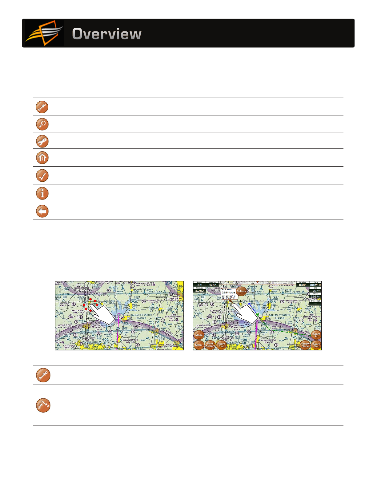
Option 1: Create a point-to-point plan by touching the screen
5. If you have a current flight plan, it will be
cancelled and a new plan will be created with
one route directly from your current location to
your selected point.
6. If needed, you can modify the flight plan by
“bending” route line. Touch the line at any
point and drag it to a new position (see page 20).
1. Pan the map until you find your desired airport
or other flying destination.
2. Touch the destination and hold for 2 seconds to
display the Possible Actions menu.
3. Select the “Fly Direct to Here” option. 4. If there are any airports or NAVAIDS near your
selected destination, you will be given a list
to select from. (Or you can select the latitude/
longitude if your destination is not associated
with a particular airport or NAVAID).

171717
Flight Planning
Option 2: Find an airport by code or keyword
1. Touch Menu Fly Direct To.
2. The Fly Direct To Screen will appear. Use this screen to find airports or NAVAIDS.
Fly Direct To Screen
Enter airport code
or airport name
Note: if entering
airport name, select
“Perform full text
search” below
Delete entry in the “Search For” field
Returns last used
search criteria
Continue touching
to see previous
Limits search
to airport and
NAVIAD codes
Searches airport and city
names for the entered text
Check to include indicated
items in the search
Begin searching
entire Adventure Pilot
Airport database
Return to map display
3. If flying to an airport, enter the Airport Code and touch Search.
• If the code is unknown, enter a portion of the airport’s name or city, select the Perform full text search
option, and then touch Search.
• If more than one object is found, a list of objects matching your search criteria will appear. The list is sorted
by distance from your current location.
• If you have a current flight plan, it will be cancelled and a new plan will be created with one route directly
from your current location to your selected point.
• Supports UATS-style keyboard entry of flight plan waypoints. Enter a route list of identifier codes
separated by spaces; the K is required for airports, otherwise you may add a Navaid into the plan by
accident (e.g. KDFW KTKI KSTL KOSH)

181818
Flight Planning
Option 3: Use the Flight Planner
The Flight Planner can be used to create a flight plan from scratch, tweak a current flight plan, change the order
of waypoints, cancel a flight plan, save plans, or load previously saved plans. It can also be used to review flight
time and fuel consumption estimates.
1. Access the Flight Plan Screen by touching the Flight Plan button. If a flight plan is currently active, the points
and route information will be shown.
Flight plan name
(defaults to:
“departure +
destination +
waypoints”)
Recalculate flight
plan and remove
intermediate
waypoints
Clears current
flight plan and
displays Set
Departure Point
button
Reverse the currently
loaded flight plan for
your return flight
Save the currently
loaded flight plan
Load a saved flight plan
(from this screen you can also
delete unwanted flight plans)
Returns to the map
display with the new
flight plan active
Modify final
destination or
waypoint options
Information on all
the airspaces your
flight plan crosses
(see page 22)
Basic route info,
including distance,
true course,
estimated flight
time, and estimated
fuel burn
Modify estimated
speed,fuel burn,
climb rate, and
descent rate of your
aircraft (see step 5)
Vertical flight planning
(see page 21)
2. If there is not an active flight plan, an initial destination will be selected based on your current location.
However, your “current” location may not actually be where you want to initiate your flight plan. For example,
if you are preparing a plan at home before heading to the airport. If this is the case, touch Clear All to start
with a blank plan, then touch Set Departure Point.
3. After a departure point is set, begin adding additional points to your plan. Touch Add Waypoint and complete
the Fly Direct To Screen as described in “Option #2: Find an airport by code or keyword” on page 17.

191919
Flight Planning
4. Next to each point in the flight plan is an Opts (options) button. Touch Opts to open a menu if you want to see
available waypoint information, remove, change, move, or insert additional waypoints.
5. Touch Aircraft Profile at the top/right of the Flight Plan Screen to modify the estimated speed,fuel burn,
climb rate, and descent rate of your aircraft.
Note: These values are used to estimate the flight time and fuel burn between routes. Setting these values to
appropriate and conservative numbers for your aircraft is critical for obtaining the most accurate estimates.

202020
Flight Planning
Option 4: Rubber-band route modification
After creating your initial flight plan, it may be tweaked by touching and dragging a route line or waypoint.
You may need to tweak a flight plan if you find that it travels through areas or airspaces that should be avoided
(such as a TFR, restricted airspaces, undesired controlled airspaces, etc.). Or you may wish to follow a specific
VFR corridor, follow an area of low terrain, or for any other reason you wish to “customize” your route.
1. Touch a route line for about ½ second to “grab”
the route. Then slowly drag the route to your
desired position. This will insert a new waypoint in
your plan.
Note: Don’t wait too long to begin dragging or the
Possible Actions menu will appear.
2. To drag an existing waypoint, touch the waypoint
for about ½ second to “grab” it, then slowly drag
the waypoint to a new position.
3. After you release the route line, a list of Waypoint
Options will appear showing the airports or
NAVAIDs in the area. Choose one to insert it into
your flight plan or choose Lat/Lon to save your
new route.
4. This process can be repeated to insert or move
waypoints as desired.
Notes:
• After a route line has been moved, it is
recommended you scan the entire route
again to ensure it has not been moved over
undesirable airspaces.
• The ability to touch-and-drag route lines can be
disabled in the Setup Menu.
Other manuals for iFLY GPS
1
Table of contents
Other Adventure Pilot GPS manuals


