Adventure Pilot iFly 700 User manual

Owner’s Manual
iFly 700™
Copyright 2011 by Adventure Pilot, LLC. iFly 700 is a trademark used by Adventure Pilot, LLC. Version 5, Rev G 05/11

2
Contents
Overview
Package Contents ................................................. 3
Features ................................................................ 3
Warnings .......................................................... 4
GPS and Source Data Notes ........................... 4
General Notes .................................................. 4
Mounting on a Windscreen ............................ 6
Connecting to Power ....................................... 6
Powering On ................................................... 6
Updating your iFly 700 ......................................... 7
Main Display ........................................................ 8
Using the Touch-Screen ........................................ 9
Panning ........................................................... 9
Activating Buttons .......................................... 9
Button Fading ............................................ 9
Switching Sectionals ...................................... 9
Markers ........................................................... 9
Menus and Screens
Main Menu .......................................................... 10
Find Nearest... Menu ..................................... 10
Setup Menu .....................................................11
Instrument Setup Form ............................ 13
Custom Locations Menu ............................... 13
Custom Locations Form ........................... 13
About Menu ................................................... 14
GPS Overview Screen .............................. 14
Mode Menu ......................................................... 15
Possible Actions Menu ....................................... 16
Airport Information Screen ................................ 17
Plate Viewer Screen ....................................... 18
Flight Planning
Flight Planning Options ..................................... 19
Option #1: Create a point-to-point plan by
touching the screen ...................................... 20
Option #2: Find an airport by code or
keyword .......................................................... 21
Fly Direct To Screen .................................. 21
Option #3: Use the Flight Planner ................ 22
Option #4: Rubber-band route
modification ................................................... 24
Airspace Info Form ........................................ 25
Airspace Display Levels ........................... 25
Altitude Planning ........................................... 26
Airspace Alerts .............................................. 27
Extra Features
Using the Remote Control ................................. 28
System Menu ...................................................... 29
Transferring Media Files to Your iFly 700 ..... 30
Video Player Optimal Settings ................. 30
Transferring Audio and Video Files to
the Play List ............................................... 31
Using the Multimedia Player ........................ 32
Using the Video Player .................................. 33
Using the Image Viewer ................................ 33
Changing Configuration Settings ................. 34
Using the Clock .............................................. 35
Using the Text Viewer .................................... 35
Using the Memo Screen ............................... 36
Using the Calculator ...................................... 36
Playing the Card Game ................................. 37
Using an External Audio/Video (AV) Device ... 37
Using an External Camera ............................ 38
Using NMEA Output ...................................... 38
Additional Information
Frequently Asked Questions .............................. 39
Specifications ...................................................... 40
FCC Information .................................................. 40
Limited Warranty................................................. 41

3
Features
Interface
Extensive zoom levels from 2 to 100 NM per inch
Touch-n-drag scrolling, works even in turbulence
Single-touch zoom in/out
Center and auto-track with a single touch
“View Charts” button switches between
bordering sectionals at a single touch
Night Mode darkens and inverts colors at night
Plug-and-fly autopilot capability
Spatial Awareness
Pre-loaded with FAA published sectionals, charts,
plates and more
Critical and important airspaces are highlighted
and shaded
Reference distance and bearing to any point on
the chart with a single touch of the screen
“Find Airport” button shows a list of the nearest
airports with immediate navigational aids such as
distance, turn, and ETE
Distance rings around your current position
FAA published TFRs on all sectionals and charts
FAA Charts
Includes all sectionals, low enroute charts,
approach, and departure plates
Explore charts with touch-sensitive panning and
zooming
Reference actual FAA airport taxi diagrams;
includes alpha-numerics for cutoffs and parallels
“History” button toggles between charts,
previously viewed airport details, and plates
Sectionals and plates include all of the “Border”
and “Legend” data as shown on FAA charts
Simple update process at www.iflyGPS.com
Flight Planning
“Direct-to” flight planning
Easily create multi-leg flight plans directly from
the sectional or flight planner
“Rubber-band” route line modifications (touch
and drag a route line to bend it around an
airspace)
Vertical speed to target for custom waypoints
with specific altitudes (a 3-D flight plan)
Save/load/reverse flight plans
Flight plan is automatically saved and restored
between power cycles
Search for airports by code, airport name, or city
name
Airport Information
Geographical data
Public and private airports
Attendance schedule
Communication information
Full runway information, including a thumbnail
with quick reference numbers
Traffic patterns with pattern altitude (if published)
Available IFR equipment
Obstructions
Additional FAA remarks
Data Updates
Unlimited updates from any internet-connected
computer (with a low-cost annual data
subscription)
Quickly update the latest TFR and Metar data
prior to your flight
Download software updates at www.iflyGPS.com
and always have the latest new features
Package Contents
iFly 700
Carrying Case
Window Mount
Remote Control
AC Adapter
Cigarette Lighter Adapter
SD Card
Quick Start Guide
Overview

4
Overview
Warnings
Carefully review this Owner’s Manual and make sure you thoroughly understand iFly 700’s functionality and
operation before attempting to use the unit during actual flight.
Do not install the iFly 700 where it obstructs the pilot’s field of view or interferes with operating controls.
The flight indicators shown on the iFly 700 are based on GPS-derived data and may differ from the aircraft’s
instruments.
The altitude shown on the iFly 700 is geometric height above Mean Sea Level and may differ from the altitude
displayed by pressure altimeters. Always use the pressure altitude displayed by your aircraft’s altimeter for
determining aircraft altitude.
While flying, compare indicators from the iFly 700 with other available navigation sources, including the
information from cockpit gauges, other NAVAIDs, visual sightings, charts, etc. Although unlikely, it is
possible for erroneous operation to occur with the iFly 700. It is the responsibility of the pilot to resolve any
discrepancies before continuing navigation.
GPS and Source Data Notes
The United States government operates the Global Positioning System (GPS) and is solely responsible for
its accuracy and maintenance. The GPS system is subject to changes which could affect the accuracy and
performance of the iFly 700.
Interference from GPS repeaters operating inside nearby hangars can cause an intermittent loss of altitude
and heading displays while the aircraft is on the ground.
The data contained in the terrain and obstacle databases comes from government agencies. Adventure Pilot
cannot guarantee the accuracy and completeness of the data.
Temporary Flight Restriction (TFR) data is provided by the FAA and may not be updated outside of normal business
hours. Confirm data currency through alternate sources and contact your local FSS for interpretation of TFR.
Do not use outdated sectional maps. Sectionals must be updated regularly to ensure that the information is
accurate. Pilots using outdated sectionals do so at their own risk.
General Notes
Avoid using any chemical or abrasive cleaners on the touchscreen and/or plastic casing. Clean the
touchscreen with a soft, clean, lint-free cloth. Use water, isopropyl alcohol, or eyeglass cleaner, if needed.
The iFly 700 does not contain any user-serviceable parts. Repairs should only be made by an authorized
service center. Unauthorized repairs or modifications could void both the warranty and the pilot’s authority to
operate this device under FAA/FCC regulations.
All visual depictions contained within this document, including screen images, are subject to change and may
not reflect the most current iFly 700 GPS receiver. Depictions may differ slightly from the actual unit.
Use of polarized eye wear may cause the flight displays to appear dim or blank.
Only use the power adapters provided with the iFly 700 or recommended by Adventure Pilot LLC.
Do not leave the iFly 700 in extremely high or low temperatures. Do not use in a humid environment or
submerge in water.
Do not place near magnets or large speakers. Do not put gold, metallic objects, or electric wave emitting
objects around the iFly 700.
5
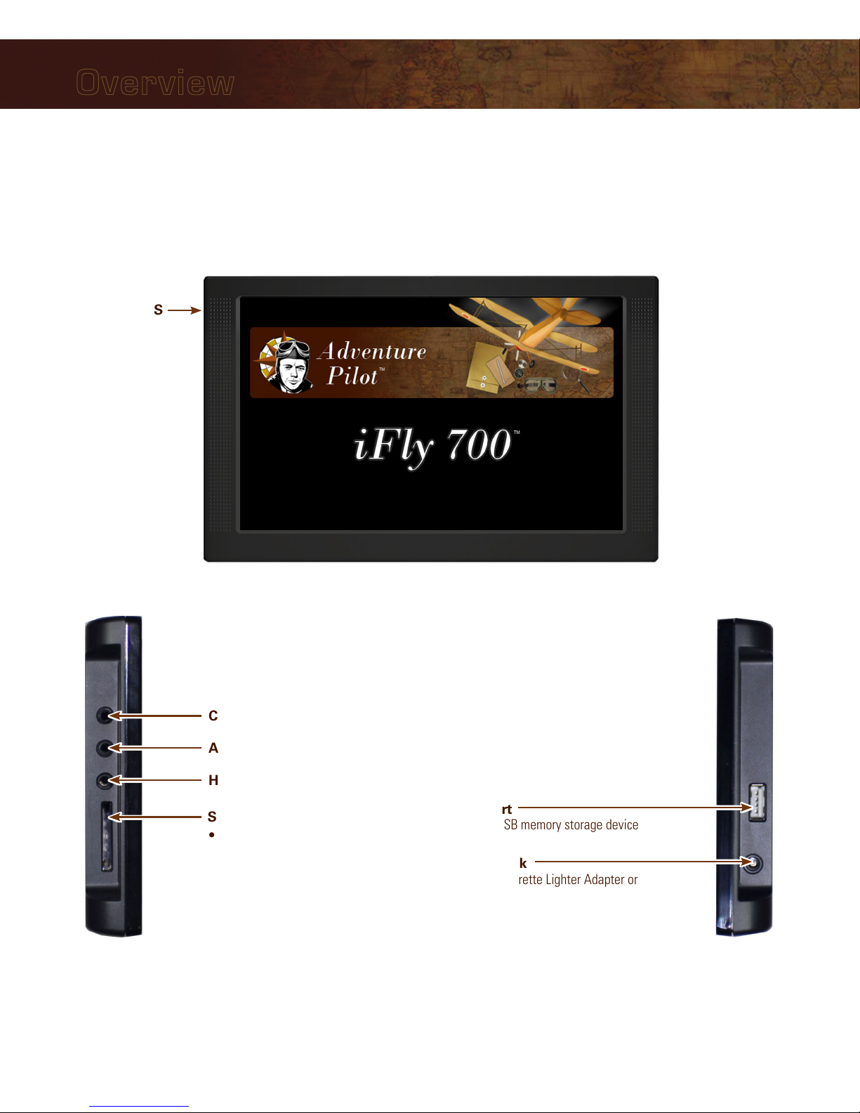
Overview
Power Jack
Connect Cigarette Lighter Adapter or
AC Adapter
USB Port
Connect USB memory storage device
SD/MMC Memory Card Slot
• Included 4G SD card contains iFly 700
applications and data
• Card must be inserted for unit to
operate
• Do not remove or modify files
Headphone Jack
AV In – Connect external video or audio device
Camera – Connect an external camera (not provided)
(on back)
External GPS
Connector
Connect an external
GPS antenna (optional,
not included)
Unit Overview
6
Overview
Mounting on a Windscreen
1. Secure the suction cup to your aircraft’s windscreen.
2. Insert the end of the mounting arm into the keyhole slot on the back of the unit.
3. Tighten the knob closest to the keyhole clockwise until secure.
4. Tighten the next knob clockwise to further secure the unit from vibrating loose.
5. Loosen the two arm adjustment knobs, position the unit as desired, and re-tighten the arm adjustment knobs.
Notes:
• Do not install the iFly 700 where it obstructs your field of view or interferes with operating controls.
• After installation, make sure the unit is firmly secured.
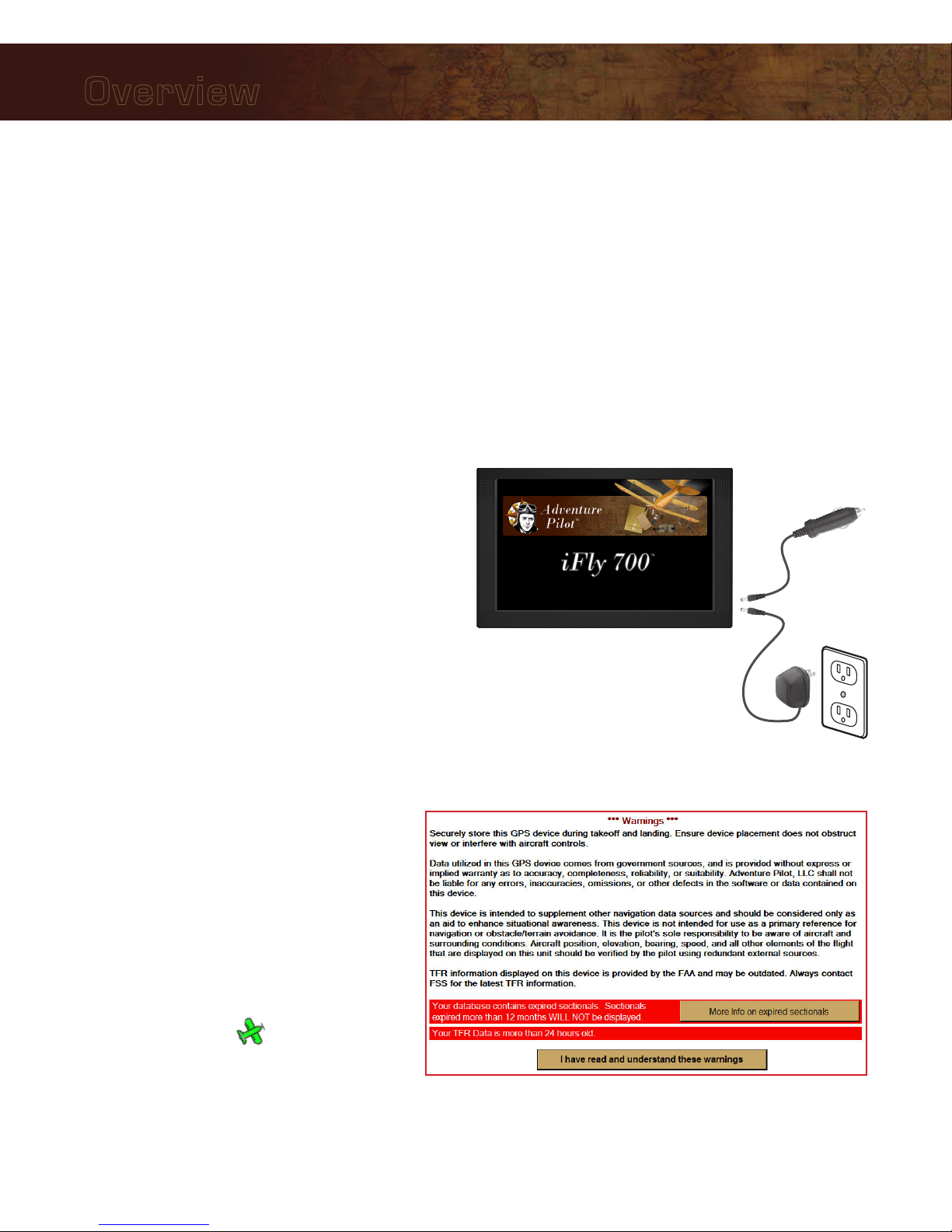
Connecting to Power
For use in your aircraft, connect the barrel end of the
included cigarette lighter adapter into the jack of the
iFly 700. Plug the other end into a DC 12–28V cigarette
lighter (accessory power port).
For use indoors, connect the barrel end of the included
AC adapter into the DC-12V jack of the iFly 700. Plug
the other end into a standard household outlet.
Powering On
1. The unit automatically turns on when connected to
power.
2. The Home Screen is displayed during
initialization while the iFly 700 collects
satellite data and establishes its present
location.
3. After initialization, a dialog box appears
containing safety warnings, and if
applicable, TFR and sectional expiration.
Touch “More info on expired sectionals”
to view the Sectional Information dialog
box.
Touch”I have read and understand these
warnings” to continue.
4. The sectional map of your location is
displayed with an icon representing
your aircraft shown in the center of the
screen.
-or -

7
Overview
Updating your iFly 700
The iFly 700 software, databases, and charts can be updated through the iFly 700 website. To perform the update
you will need: 1) a USB Flash Drive, 2) a login to the website, and 3) a valid update subscription.
The website is http://www.iFlyGPS.com.
If you do not have a login, create one by clicking the “Register” button at the top of the screen. Be sure to keep
your login and password in a safe location. Once registered, it will be necessary to link your new iFly 700 with
your account.
If your purchase included a free trial subscription, activate it by selecting the “Updates / Active Free Trial” option
and entering your iFly 700 serial number and the activation code included with your purchase.
If your purchase did not include a free trial, you will need to purchase a subscription through the online store.
Performing the Update
1. Click the “Updates / Create Update Package” menu option on the website.
2. Insert a USB Flash Drive into your computer.
3. Using the checkboxes on the Updates page, select the items you would like to update.
Notes:
• It is not necessary to update every chart that expires; we recommend you only update data that is relative
to your flights. (If you are planning a cross country trip that takes you into areas you don’t usually fly, you
can download that data at any time prior to your flight.)
• The first three checkboxes in the list: “TFRs & METARS,” “Airport & Navaid Database, and “Software”
should always be updated when available.
4. Click the “Create Update Package” to create your update package. Depending on what you have selected,
this may take a few seconds or more than a minute.
5. When the package is created, you will be able to download the resulting file (called iFlyUpdatePackage.zip) to
your USB Flash Drive.
Note: This step varies greatly based on your computer’s hardware, operating system (OS) (Windows or
MAC), specific OS versions, USB Flash Drive type, and the browser you are using. Please consult your OS or
browser documentation to learn how to download files.
6. Eject or stop the USB Flash Drive.
Note: Do not pull the USB Flash Drive out of your computer without first ejecting or stopping it. Consult
your OS documentation for information on how to eject or stop your USB Flash Drive. If this step is not
accomplished, the file may not be completely copied, and the update process will fail.
7. Insert the USB Flash Drive into the iFly 700, then select Menu Check for Update File. The update
process will commence. Do not disconnect power or attempt to do anything else with the iFly 700 until the
update is complete.
8
Overview
Speed
Use Menu Setup to toggle
between Miles, Kilometers,
and Nautical Miles
Track
The direction your aircraft
is moving relative to true
North
Altitude
Your altitude in feet
above sea level
calculated by GPS
Warning: Always
use your aircraft’s
pressure altimeter
to determine your
exact altitude
Menu
Opens the Main
Menu (see page 10)
Zoom In
Zoom in to read
map details
Zoom Out
Zoom out to view
surrounding areas
and airspaces
Follow Plane
Reposition your current location in
the center of the screen
Location Icon
Indicates your
current location on
the sectional
Mode
Select the map
mode (see page 15)
Find Airport
Shows a list of nearby
airports
Flight Plan
Shows the flight planning
form (see page 22)
Navigation Instruments
Available when a flight plan is active
(see page 19)
Main Display
North-up
Toggles the map display between North-up
and Track-up
• In North-up mode, the chart is always
oriented so that North is up.
• In Track-up mode, the chart is oriented so
that the plane is located at the bottom/
center of the map facing straight up and
the map will rotate as the airplane turns.
Note: If you pan the map, the orientation
will freeze. When you touch Follow
Plane to resume tracking the airplane,
the map will again rotate to maintain
track-up orientation.
History
Shows a list of
recently viewed
Airports and Plates
Alert
Appears when there is
an airspace alert to be
viewed; touch to view
details about the alert
(see page 27
9
Overview
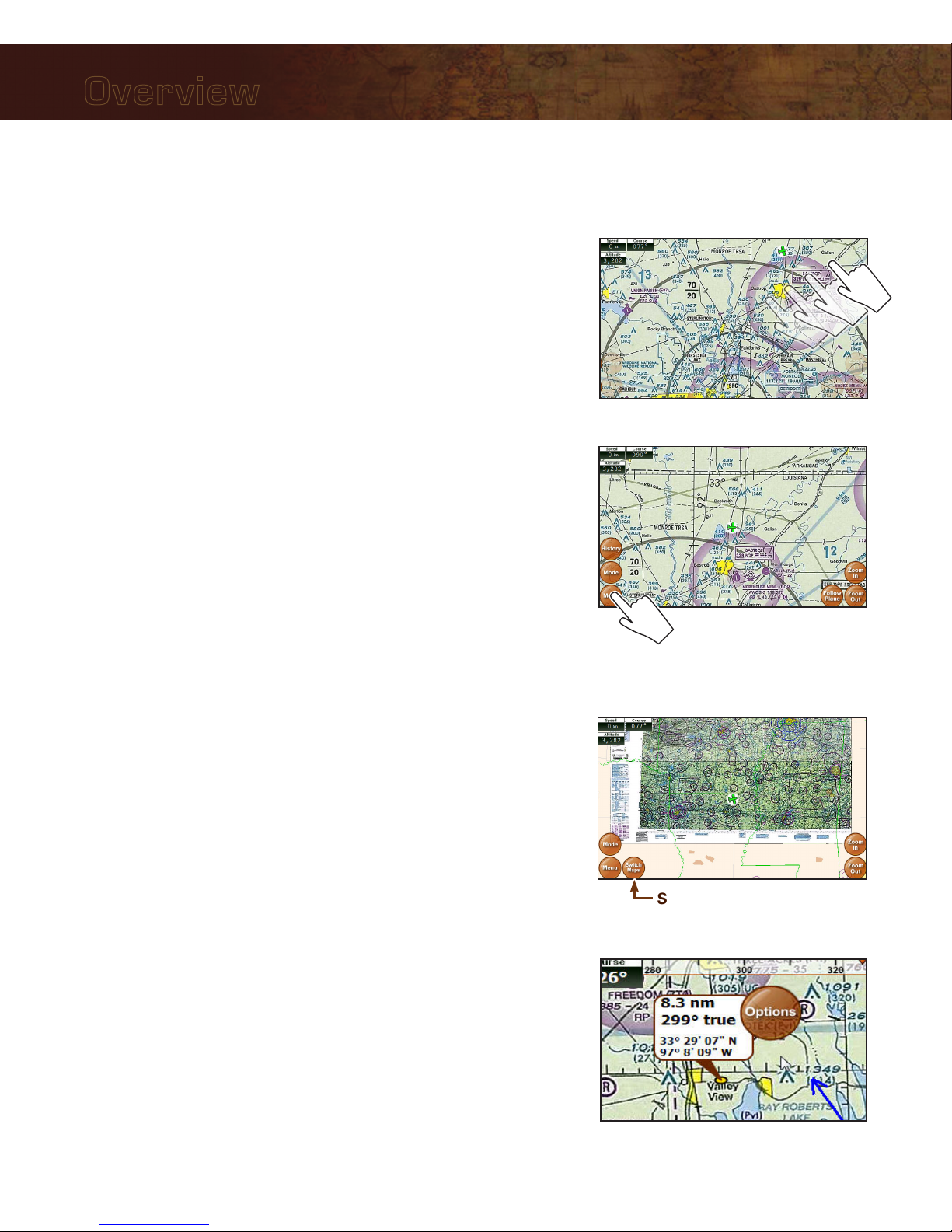
Using the Touch-Screen
Panning
Swipe your finger across the map to move (or “pan”) the view to
another area. Panning temporarily hides all the instruments and
buttons on the map. This can be useful if you need to see text or an
image that is behind something else on the map. For example, the
Altitude instrument may be covering an airport frequency.
Activating Buttons
Activate buttons by touching with your finger and releasing. This works
for buttons on the map (Menu, Zoom In, etc.), and buttons on the
forms and dialog boxes.
Button Fading
In order to maximize the amount of screen available for displaying the
map, the control buttons will fade to be almost invisible after about 30
seconds. However, the buttons are still active in this mode. Touching a
faded button works the same as touching a non-faded button.
Note: You can change button fade settings in the Setup Menu.
Switching Sectionals
Only one sectional is displayed at a time (however, both sides of
the sectional are shown at the same time). To switch to another
sectional, touch the area of the screen that contains the sectional you
wish to view and it will be brought into the foreground. Sometimes
two sectional maps will overlap each other. If you wish to view the
sectional that’s “underneath” the currently display map, touch the
Switch Maps button. The Switch Maps button will only be visible if
two or more sectionals are within the boundary of the current screen.
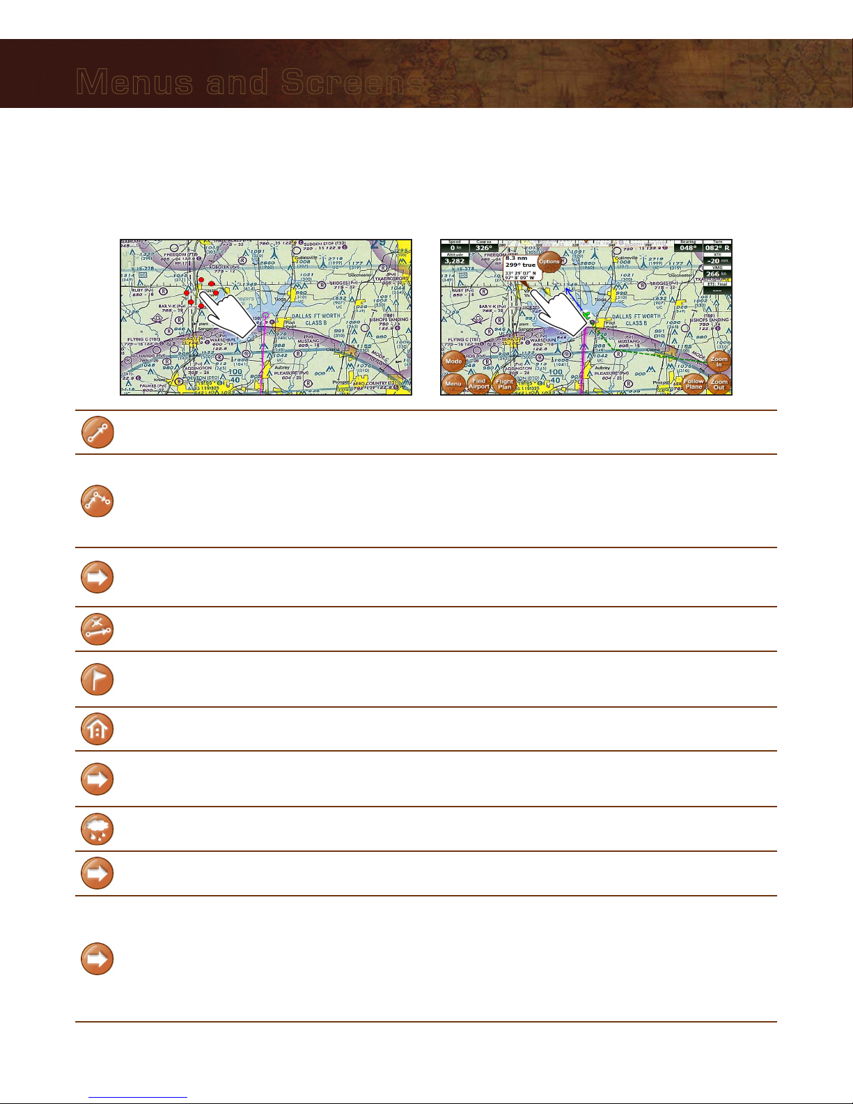
Markers
Tap the screen with your finger to drop a marker on the map. The
marker displays the distance and course from your current location
plus the latitude/longitude of the spot you touched. It disappears after
about 10 seconds.
You can also place a permanent marker at the location (useful for
keeping track of your distance and course from a particular point on
the map) or access other options by touching the Options button that
appears with the marker. See Possible Actions Menu on page 16.
Switch Maps
Panning the view

10
Main Menu
Access by touching Menu on the bottom left-hand corner of the map display.
Fly Direct To Quickly set a route by entering the airport code or name in the Fly Direct To
Screen (see page 21).
Find Nearest... Find the airport or NAVAID closest to your current location (see below).
Setup Customize display settings (see page 11).
Custom Locations Create and manage custom locations (see page 13).
Check for Update File Update sectionals and application data (see page 7).
About Obtain information about GPS, sectionals, version, and support (see page 14).
System Menu Access additional functions such as the calculator, multimedia, memos, and
connected audio/video devices.
Find Nearest... Menu
These searches will display up to 26 airports or NAVAIDs within 50 NM of your current location. Access by
touching Menu Find Nearest...
Airport
Displays a list of nearby airports. Choose an airport and touch Select to view
information about the airport, including latitude/longitude, public/private, radio
frequencies, runway conditions, and additional information.
Airport w/ Weather
Displays a list of nearby airports that broadcast NOAA weather information.
Choose an airport and touch Select to find weather frequencies. You will need
to tune your radio to the frequency to hear weather information.
NAVAID
Displays a list of nearby Navigational Aids. Choose one and touch Select to
flag the NAVAID location and return to the map display. The newly flagged
NAVAID is shown centered in the display.
Menus and Screens

11
Menus and Screens
Setup Menu
Access by touching Menu Setup.
Units of Measure
Speed Distance
Measurements Switch between nautical miles, statute miles, and kilometers.
True or Magnetic
North
Toggles the system between showing degrees as True or Magnetic
North.
Map Settings
Distance Circles
Check Visible to draw distance circles around the plane icon on the
map. The distance varies from 2 NM to 2500 NM based on your
zoom level. Check Visible and Annotated to show the distances on
the map.
Course Line When enabled, a blue arrow will be extended in front of the plane
indicating course currently being traveled.
Flight Trails Check Visible to draw a trail showing where you’ve flown in the
current flight plan.
Past Flights
The iFly 700 remembers all past flights and lists them with the date and
time stamp of departure. Select one and touch Load to draw the flight
trail on the map.
Note: The unit doesn’t center on the flight trail; you may have to
zoom out and search through the maps to find it.
Display Intended
Track Line
When enabled, a blue line is drawn from your current location to
your targeted waypoint.
Auto Track Plane
Causes the plane to automatically re-center.
Disabled: Auto track feature off
Enabled: Auto track feature on at all times
Enabled While in Motion: Auto track is off while the iFly 700 is
not moving (such as while you’re planning a flight), but is on if
the unit is in motion (while flying)
Duration: 10 Seconds through 10 minutes
Touch and Drag
Route Lines Allows you to disable touch-and-drag route lines.

12
Menus and Screens
Setup Menu Continued
Alerts and Warnings
Special Use
Airspace Options
Customize how specific airspaces are displayed: Hidden, Shaded,
Outlined, or Shaded and Outlined
Note: Some airspaces will not be shown at higher zoom levels. See
page 25 for a table of airspace display levels.
Airspace Alerts
Provides a warning before flying into an airspace (see “Airspace
Alerts” on page 27).
Types: For each airspace type (Class B, TFR, etc.), select No
Warnings (disabled), Show Alert Button (unobtrusive), or
Show Pop-Up Alert Message (obtrusive).
Altitude Buffer: Select the altitude (100 ft, 200 ft, etc.) above or
below the airspace that will encompass the warning.
Alert Distance: Select when the alert will appear in terms of
time or distance (20 minutes, 10 minutes, 20 NM, 10 NM, etc.)
Vertical Speed to
Target Settings
Modify the settings for when the Vertical Speed to Target (VST)
instrument will appear. VST shows the required ascent or descent
rate required to reach your target altitude (see page 26).
Customize Instruments
Allows you to customize instrument appearance: hide, show, or
change location, size, and color. When selected, the Instrument
Setup Form is shown (see page 13).
NMEA Output
Customize settings for sending GPS information to external devices
that understand a GPS signal, such as a fuel computer or autopilot.
Note: A special USB-to-Serial cable is required and can be purchased
at www.iFlyGPS.com.
Screen Settings
Calibration
Adjust the backlight, calibrate the touch screen, adjust time and date
settings, and view system information (see page 34).
Note: When calibrating the touch-screen, use a stylus, toothpick, or
plastic pointed object.
Screen Brightness Toggle screen brightness up or down.
Button Fading Control how much the buttons fade when not in use.

13
Menus and Screens
Instrument Setup Form
Use this form to customize the appearance of your instruments. Access by touching Menu Setup
Customize Instruments. Note: You can also select instrument modes from the Mode Menu.
• Select Basic or Extended
• Select “Create New
Group” to create a new
custom grouping of
instruments
Touch and drag an instrument
to a new location
Touch an instrument to flag
it for change or removal
Touch the Change
Color button
Touch the Change
Size button
Add or remove
instruments
Custom Locations Menu
Access by touching Menu Custom Locations.
Create New Custom Location Opens the Custom Locations Form.
Edit Custom Locations Displays a list of your saved Custom Locations so you can edit or
delete them.
Show on Map? Allows you to choose whether to show or hide your custom locations
on the map.
Custom Locations Form
This form allows you to define the name and location for your custom location. Access by touching Menu
Custom Locations Create New Custom Location.
The name defaults to
“Custom Location #”
Change the name
of your custom
location
Displays a dialog box
to manually enter the
latitude and longitude
Sets the lat/lon to the
current location of the GPS
Sets the lat/lon
to the center of
the map.
14
Menus and Screens
About Menu
Access by touching Menu About.
GPS Information Displays the GPS Overview Screen (see below).
Sectional Information
Displays your current list of sectionals in order of expiration date. You
can turn off sectional expiration warnings by unchecking.
Note: The FAA publishes updated sectionals one day prior to the
sectional’s expiration date. Adventure Pilot makes every effort to get
new sectionals ready for download within 24 hours.
Version and Contact This shows the current software version of your iFly 700, as well as
Adventure Pilot copyright and contact information.
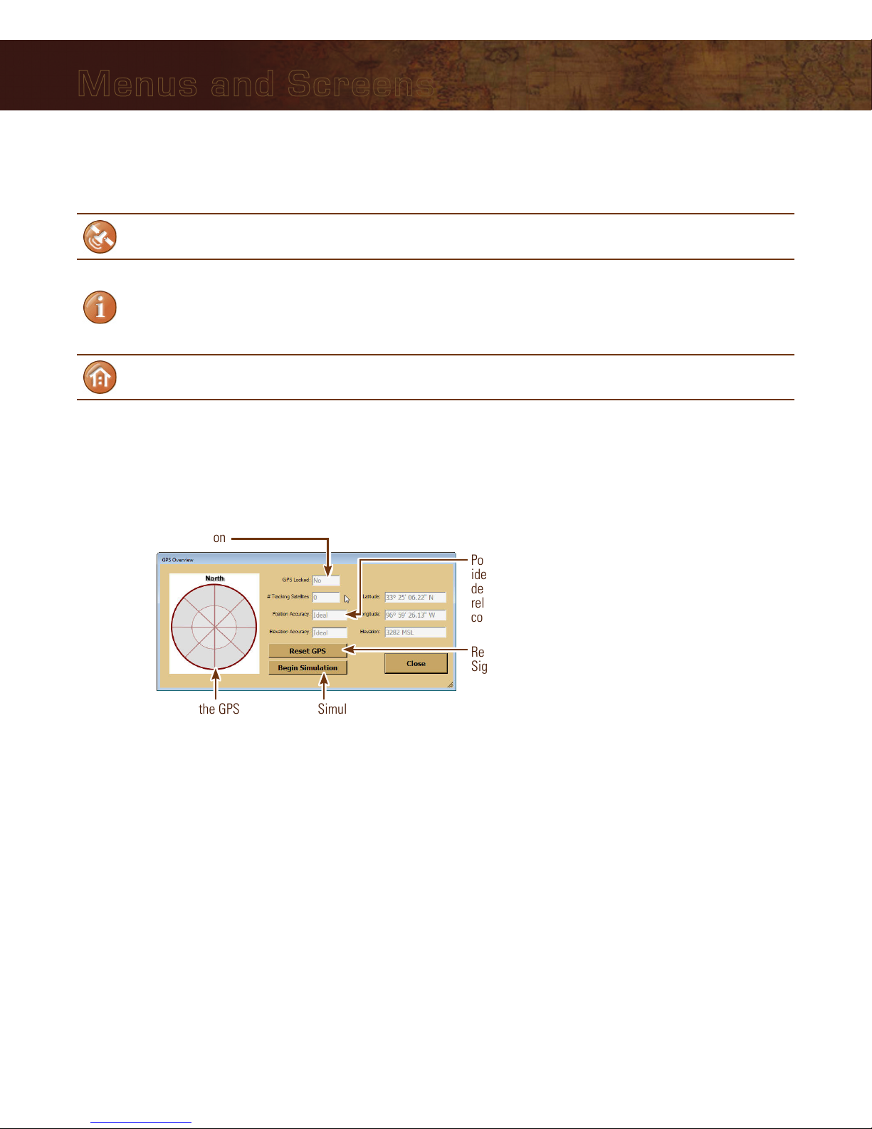
GPS Overview Screen
Access by touching Menu About GPS Information.
Position and elevation accuracy may be
ideal, excellent, good, moderate, fair, or poor,
depending upon a combination of factors
related to satellite position and atmospheric
conditions
Map of the GPS satellites
locked by your unit
If GPS locked = yes, the unit knows where you are
If GPS locked = no, the unit is still trying to process
your location
Reset GPS if you repeatedly get a “Weak GPS
Signal” message. It may take up to 30 minutes
to re-acquire a signal lock (see page 39)
Simulate flying around
with the iFly 700

15
Menus and Screens
Mode Menu
Touch the Mode button on the Main Screen and select one of the following options to change the map mode.
Sectional Charts Map based on the sectional charts.
Low-Enroute Charts Map based on the IFR Low-Enroute charts.
Terminal Area Charts Map based on Terminal Area Charts.
Vector
Vector mode provides an uncluttered view of surrounding airspaces
and SUAs (Special Use Airspaces) using the following color codes:
Purple = Warning
Gray = MOA (Military Operations Area)
Yellow = Alert
Orange = Restricted
Red = Prohibited or TFR (Temporary Flight Restriction)
Metars
A variation of Vector mode where METAR weather information
is shown on the map as a shaded circle over each FAA weather
reporting station. The circle’s color will indicate the conditions:
Green: VFR
Red: IFR
Blue: Marginal VFR
Magenta: Limited IFR
Details on the METAR can be retrieved by holding your finger on or
near the desired circle and selecting Details on nearest METAR.
A line extending from the center of the metar indicates wind speed
and direction.
Day / Night Mode
When Night Mode is selected:
The screen will be fully dimmed.
Sectional, TAC, and EnRoute charts will be darkened by 50%.
The Plate Viewer (for viewing approach plates, airport diagrams,
etc.) will present the plate in inverted colors.
The Airport Information page will use darker background colors.
Select Instrument Mode Activate Basic, Extended, or a Custom instrument group (see page 13).
16
Menus and Screens
Possible Actions Menu
Activate the Possible Actions menu by either:1) Holding your finger down over the same spot on the map
(without swiping it to another spot), or 2) Touching a spot on the map and then touching the Options button.
or
Fly Direct to Here... Creates a flight plan directly to the selected location (see page 21).
Add Waypoint Here...
(Shown if an existing flight plan is
active.)
Inserts the selected location as a waypoint in an active flight plan. If
the flight plan has multiple legs, the system will insert the waypoint
in the most appropriate leg.
Note: If the selected leg is not the desired leg, use Flight Planner to
modify the waypoint (see page 22).
Direct to this Waypoint
Targets a waypoint and bypasses other points in the plan.
Note: This can only be used to target “future waypoints.” Waypoints
that have already been passed cannot be targeted with this option.
Remove this Waypoint Removes the selected waypoint.
Drop Marker Here
Adds a permanent marker to display the distance and course from
your current location. This is useful for keeping track of your distance
and course from a particular point on the map.
Add Custom Location Creates a custom location (see page 13).
Airport Information
Displays the Airport Information screen (see page 17). If there is more
than one airport near the touch point (common when zoomed out),
select one from the list of airports near the touch point.
Details on nearest METAR This option will be shown if the METAR data is less than 24 hours
old. Note: if in METAR Mode, this option will always be shown.
Airspace Information Displays information on the airspaces located at the touch-point.
Show Extended Runway
A list of runways is shown to help you visualize how to approach
an airport. Select one and a triangle is drawn showing the correct
approach for a straight-in landing. The point of the triangle represents
the start of the runway.
Note: For airports (especially private airports) where runway end-
point lat/lon is not known, the arrow will be based on the runway’s
magnetic designator and the center point of the airport.

17
Menus and Screens
Airport Information Screen
Access by touching the Find Airport button and selecting an airport from the list. This screen provides important
information about an airport, including:
Airport code and name
Latitude/Longitude
Public/private status
If a control tower is present, and what hours that tower is open
All utilized communication frequencies
A list of runways with detailed information about each runway’s orientation, condition, lighting, traffic pattern,
IFR equipment, markings, and obstructions
Any additional FAA published remarks about the airport
Note: Airport NOTAMS are not available on this screen. Always contact FSS for the latest NOTAMS before any
flight.
Information in the Airport Information form can be scrolled by sweeping your finger across the screen, or by
touching and dragging the scroll bar at the right of the form.
Opens a menu of plate types
available at this airport. Select
a plate to open the Plate Viewer
Screen (see page 18)
Note: Only available if the airport
supports IFR activity and the FAA
has published Approach, Departure,
or STAR charts for this airport
The map will pan until
the airport is shown
at the map center
Cancels the current flight plan (if any),
and creates a new route from your
current location to the selected airport
Inserts this airport as a
waypoint at the most
appropriate location in
an active flight plan
Displays a
list of nearby
airports
Decrease or increase
text size

18
Menus and Screens
Plate Viewer Screen
Access by touching the View Plates button on the Airport Information Screen.
The Plate Viewer Screen displays additional graphical information published by the FAA for a specific airport. The
following types of plates can be viewed:
Airport Diagrams
Published Minimums
Instrument Approaches
Departures
STARs (Standard Terminal Arrival) plates
Zoom in and out
(while zoomed in, you can pan
the chart by sweeping your
finger across the screen)
Rotate right or left to view in
landscape or portrait orientation
Shows a list of additional charts
associated with this airport.
19
Flight Planning Options
The iFly 700 includes an intuitive flight planning utility appropriate for VFR flight. A flight plan consists of a
departure point, zero or more waypoints, and a destination. These points make up a collection of “routes.” For
example, a flight plan with two points (a departure and a destination) will have one route. A plan with a departure
point, one waypoint, and a destination will have two routes. Routes are displayed on the map as magenta lines.
When choosing waypoints and destinations for your flight plan, the iFly 700 will automatically determine the most
appropriate target point based on your location, course, and flight track history.
There are several ways to create and modify flight plans:
Option #1: Create a point-to-point plan by touching the screen (see page 20)
Option #2: Find an airport by code or keyword (see page 21)
Option #3: Use the Flight Planner (see page 22)
Option #4: Rubber-band flight modification (see page 24)
w Warning: The iFly 700 does not support terrain warnings. It will not offer visual or verbal warnings about
terrain, low altitude, or obstructions. If using the iFly 700 in a low AGL situation, always remain visually aware of
surrounding terrain and obstructions.
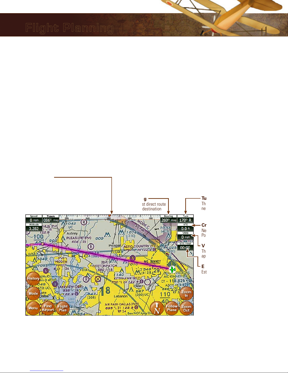
The following navigation instruments are available when a flight plan is active:
Velocity Made Good
The absolute speed you are
approaching your destination
Bearing
The most direct route
to your destination
Turn
The number of degrees you
need to turn to stay on route
Cross Track Error
Negative = distance left-of-route
Positive = distance right-of-route
ETE: Final
Estimated time left until reaching
final destination
Course Tape
The triangle indicates your current course.
The ball indicates the most direct bearing to
your next waypoint.
To follow the most direct route to your next
waypoint, keep the ball centered under the
triangle.
Touch any of the instruments to toggle between Standard and Enhanced modes. If Custom Instrument modes
have been created, touching any instrument will also toggle through those modes.
Flight Planning

20
Flight Planning
Option #1: Create a point-to-point plan by touching the screen
5. If you have a current flight plan, it will be
cancelled and a new plan will be created with
one route directly from your current location to
your selected point.
6. If needed, you can modify the flight plan by
“bending” route line. Touch the line at any
point and drag it to a new position (see page 24).
1. Pan the map until you find your desired airport
or other flying destination.
2. Touch the destination and hold for 2 seconds to
display the Possible Actions menu.
3. Select the “Fly Direct to Here” option. 4. If there are any airports or NAVAIDS near your
selected destination, you will be given a list
to select from. (Or you can select the latitude/
longitude if your destination is not associated
with a particular airport or NAVAID).
Other manuals for iFly 700
1
Table of contents
Other Adventure Pilot GPS manuals


