manuals.online logo
Brands
  1. Home
  2. •
  3. Brands
  4. •
  5. Lokatoo
  6. •
  7. GPS
  8. •
  9. Lokatoo B1000 Instructions for use

Lokatoo B1000 Instructions for use

For the latest version of this manual, please visit
www.lokatoo.com
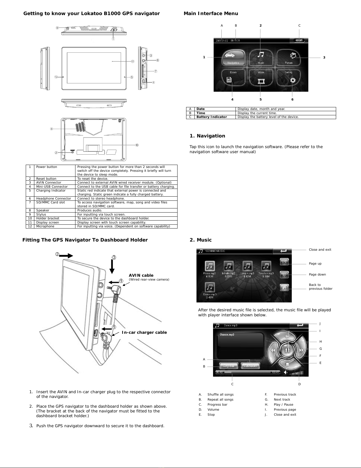
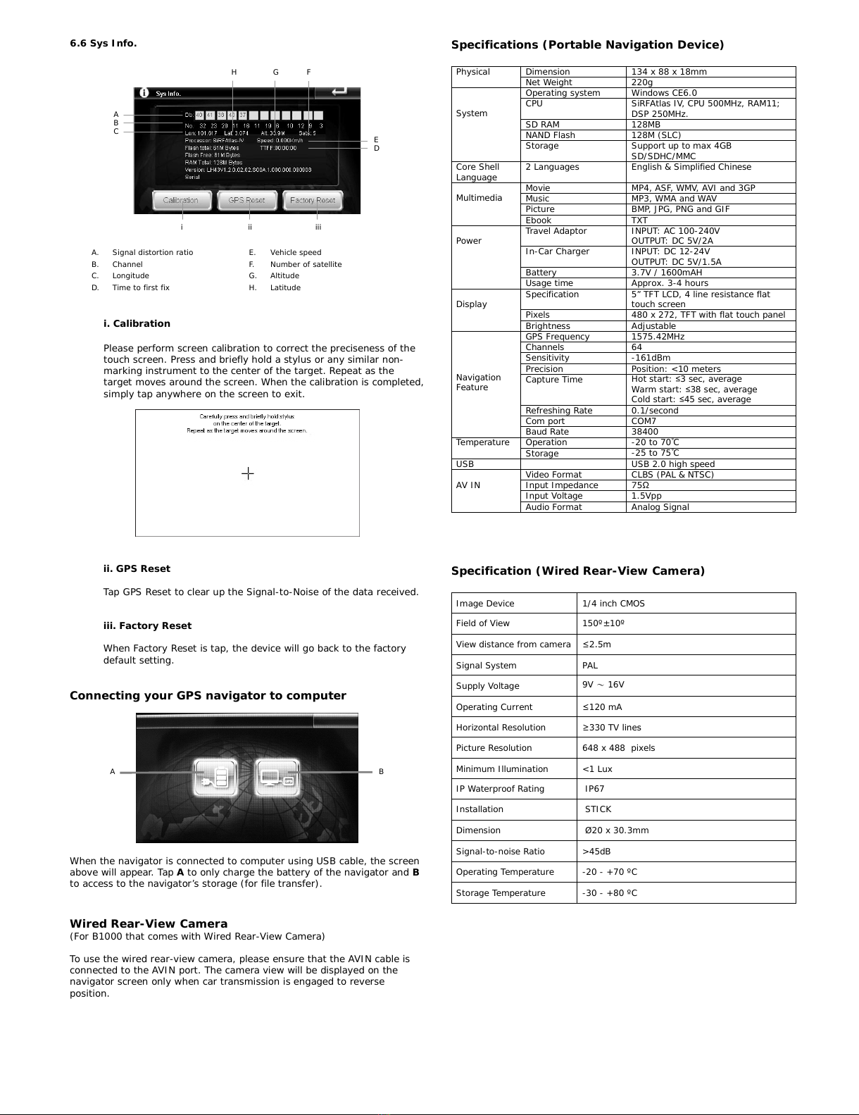
HARDWARE USER MANUAL
Lokatoo B1000
Version 2.4
TERMS & CONDITIONS
1. The maps data and/or preloaded software (“Software”) in this device are licensed by third parties to
Amtel Cellular Sdn Bhd (“The Company”). The Software is sub-licensed on a limited, non-exclusive,
non-transferable and revocable basis for use by you solely on this device only and is not sold together
with the device. If upgrades, updates or supplements to the Software are obtained, the use of such
upgrades, updates or supplements is governed by these Terms and Conditions and any amendments that
may accompany them and may be subject to additional payments and conditions. You must not
reproduce, distribute, publish, transmit, modify, adapt, translate, display, distribute, sell, license,
publicly perform, prepare derivative works based upon, or otherwise use or exploit the Software. The
foregoing limited right does not give you any ownership of Software and nothing contained in this
Agreement may be construed as conferring to you any licence or right to the Software under any
copyright or any other intellectual property right.
2. The Software is provided by the copyright holders "AS IS" and any express or implied warranties,
including, but not limited to, the implied warranties of merchantability and fitness for a particular
purpose, are disclaimed. In no event shall the copyright owner be liable for any direct, indirect,
incidental, special, exemplary, or consequential damages however caused and on any theory of liability,
whether in contract, strict liability, or tort (including negligence or otherwise) arising in any way out of
the use of the Software, even if advised of the possibility of such damage. The entire risk to the quality
and performance of the Software is borne by you. This disclaimer of warranty constitutes and essential
part of the licence granted to you to use the Software.
3. The trademarks, logos, and service marks (“Trademark”) displayed on this Software and device, are
owned by the Company and third parties. All Trademarks not owned by the Company are the property
of their respective owners, and are used with permission. Nothing contained herein may be construed as
granting any right or licence to use any Trademark.
4. The maps and any information stored in this device is strictly a navigation guide for reference use only.
It is the sole responsibility of the User’s to use this device prudently. Information provided may change
over time and you should decide the route based on the actual road conditions and traffic laws. The
Company makes no representation or warranty, whether expressly or impliedly as to the accuracy,
completeness, timeliness, reliability or fitness for any particular purpose of the maps stored therein.
5. The planned, shortest, quickest routes and estimated time to desired destinations are obtained from
optimal route calculations based on the map database and should be used as a reference only. This
device must not be used for any purpose requiring precise measurement of direction, distance, location
or topography.
6. Do not fix or mount the device on such part of the windscreen that will interfere with driving of the
motor vehicle or be hazardous or dangerous to the driver or occupants in the motor vehicle. User shall
be responsible for his/her use of the maps stored therein and the device, and shall at all times comply
with all traffic laws and regulations of the country of usage.
7. The usage of this device is dependent on the Global Positioning System (GPS) which is operated by the
United States government and is solely responsible for its accuracy and maintenance. The system is
subject to changes which may affect the performance and accuracy of the GPS navigator devices.
8. The use of the device is at the User’s own risk. Lokatoo and the company is not liable for any fines,
penalties, damages or loss whether direct, indirect, incidental, special, exemplary, or consequential
damages however caused and on any theory of liability, whether in contract, strict liability, or tort
(including negligence or otherwise) arising in any way out of the use of the device.
Precautions and Notices
For your own safety, do not operate the controls of the product while driving.
When you get off the car, do not leave your device on the dashboard that is subject to
direct sunlight. The overheating of the battery can cause malfunction and/or danger.
Global Positioning System (GPS) is operated and managed by the United States of
America Department of Defense, which is solely responsible for the performance of
GPS. Any change or modification may affect the accuracy of the GPS and its related
systems.
GPS satellite signals cannot pass through solid materials (except glass). When you are
inside a tunnel or building, GPS positioning is not available.
A minimum of 3 GPS satellite signals is needed to determine current GPS position.
Signal reception can be affected by situations such as bad weather or dense overhead
obstacles (e.g. trees and tall buildings).
Other wireless devices in the vehicle might interfere with the reception of satellite
signals and cause the reception to be unstable.
A car holder is needed when using the device in a car. Be sure to place the device in an
appropriate place, so as not to obstruct the driver’s view, or deployment of airbags.
Please remove SD/MMC card only when the device is in power off status.
When USB transmitting, Do Not disconnect the USB cable. When other applications are
operating, Do Not connect USB cable.
The navigation software may be updated from time to time. If the description shown in
this manual is different, please follow the software version currently on hand.
Battery Information
For optimal performance of the Li-polymer battery, take note of the following:
This unit contains a non user replaceable internal Li-polymer battery. The battery can
inflate and release hazardous chemicals. To reduce the risk of fire or burns, do not
disassemble, crush, puncture, or dispose of in fire or water.
The icon at the top right corner on the main interface of system indicates the
current remaining power.
Disconnect device from charger when it is fully charged. Battery may damage if it is
over charged.
Do not immediately turn on your device after connecting the Travel Adaptor to charge a
power-depleted battery. If you need to turn on the device again, wait for at least one
minute.
Do not charge the battery where the temperature is high. This may be harmful to the
battery. (e.g. in direct sunlight).
It is unnecessary to fully discharge the battery before charging. You can charge the
battery even if it is only partially discharge.
If you do not use the device long period of time, charge the battery at least once every
two weeks. Over discharge battery can affect the charging performance.
Only connect the In-Car Charger to the device after starting the car. Failure to
do so may cause irreversible damage to the device.
Amtel Cellular Sdn Bhd (278151
-
D)
No 5, Jalan PJS 7/19, Bandar Sunway,
46150 Petaling Jaya, Selangor D.E., Malaysia.
Tel: 03-5632 6788 Fax: 03-5632 5678
E-mail: customerservice@lokatoo.com
Customer Service Hotline: 1 800 88 0308
What is in the box?
01. Lokatoo B1000 GPS Navigator
02. Stylus
03. Pouch
04. In-car charger - Installed in vehicle
05. Travel adaptor
06. USB cable
07. CD containing map and manual
08. SDMMC Card c/w navigation software & map
09. Quick guide
10. Software user manual
11. Hardware user manual
All manuals and user guides at all-guides.com
all-guides.com
Getting to know your Lokatoo B1000 GPS navigator
1 Power button Pressing the power button for more than 2 seconds will
switch off the device completely. Pressing it briefly will turn
the device to sleep mode.
2 Reset button To reset the device.
3 AVIN Connector Connect to external AVIN wired receiver module. (Optional)
4 Mini-USB Connector Connect to the USB cable for file transfer or battery charging.
5 Charging Indicator Static red indicate that external power is connected and
charging. Static green indicate a fully charged battery.
6 Headphone Connector Connect to stereo headphone.
7 SD/MMC Card slot To access navigation software, map, song and video files
stored in SD/MMC card.
8 Speaker Produces audio.
9 Stylus For inputting via touch screen.
10 Holder bracket To secure the device to the dashboard holder.
11 Display screen Display screen with touch screen capability.
12 Microphone For inputting via voice. (Dependent on software capability)
Main Interface Menu
A Date Display date, month and year.
B Time Display the current time.
C Battery Indicator Display the battery level of the device.
1. Navigation
Tap this icon to launch the navigation software. (Please refer to the
navigation software user manual)
Fitting The GPS Navigator To Dashboard Holder
1. Insert the AVIN and In-car charger plug to the respective connector
of the navigator.
2. Place the GPS navigator to the dashboard holder as shown above.
(The bracket at the back of the navigator must be fitted to the
dashboard bracket holder.)
3. Push the GPS navigator downward to secure it to the dashboard.
2. Music
After the desired music file is selected, the music file will be played
with player interface shown below.
A. Shuffle all songs F. Previous track
B. Repeat all songs G. Next track
C. Progress bar H. Play / Pause
D. Volume I. Previous page
E. Stop J. Close and exit
AVIN cable
(Wired rear-view camera)
In
-
car charger cable
1
A B 2 C
3
4
5
6
Page up
Page down
Back to
previous folder
Close and exit
A
B
C D
E
F
G
H
I
J
All manuals and user guides at all-guides.com
3. Picture
After the desired picture file is selected, the picture file will be
displayed as below.
A. Previous picture E. Rotate picture
B. Next picture F. Zoom out
C. Slide show (in full screen)* G. Zoom in
D. Back to previous folder H. Close and exit
* Double tap the screen to exit full screen mode.
5. Movie
After the desired movie file is selected, the movie file will be played
with player interface shown below.
A. Display screen – double tap to
enter full screen* E. Fast-forward
B. Progress bar F. Stop
C. Volume G. Play / Pause
D. Back to previous folder H. Close and exit
* Double tap the screen to exit full screen mode.
4. Ebook
After the desired text file is selected, the text file will be displayed as
below.
A. Numeric keyboard to enter page no. D. Page up
B. Previous folder E. Close and exit
C. Page down
6. Setting
Tap Setting icon from main menu to enter the setting page. Here you can
set the volume, power, backlight, time and date and language. You can
also view system information, perform touch screen calibration, GPS reset
and factory reset.
6.1 Volume
Tap to increase and to decrease the volume. Tick “Enable sounds
for taps” to enable screen tapping sound.
6.2 Power
The “Battery Level” displays the remaining charge of the battery.
Tap or to set the time before the navigator enter sleep mode.
6.3 Backlight
Tap to increase and to decrease the screen brightness.
Tap or to set the time before the screen is turned off.
6.4 Date & Time
Time – Tap or to set the hour and minute.
Date - Tap or to set the year, month and day.
Zone - Tap or to set the time zone.
Note: You do not need to adjust the date and time. When the
device is connected to GPS satellite, the current date and time will
be downloaded to the device.
6.5 Language
Tap or to set the desired language.
Page up
Page down
Back to
previous folder
Close and exit
Go to picture
viewing page
A
B
C
H
G
F
E
D
Close and exit
Page
up
Page down
Back to
previous folder
E
D
C
B
A
Close and exit
Page up
Page down
Back to
previous folder
A
B
C
D
E
F
G
H
All manuals and user guides at all-guides.com
6.6 Sys Info.
A. Signal distortion ratio E. Vehicle speed
B. Channel F. Number of satellite
C. Longitude G. Altitude
D. Time to first fix H. Latitude
i. Calibration
Please perform screen calibration to correct the preciseness of the
touch screen. Press and briefly hold a stylus or any similar non-
marking instrument to the center of the target. Repeat as the
target moves around the screen. When the calibration is completed,
simply tap anywhere on the screen to exit.
Specifications (Portable Navigation Device)
Dimension 134 x 88 x 18mmPhysical Net Weight 220g
Operating system Windows CE6.0
CPU SiRFAtlas IV, CPU 500MHz, RAM11;
DSP 250MHz.
SD RAM 128MB
NAND Flash 128M (SLC)
System
Storage Support up to max 4GB
SD/SDHC/MMC
Core Shell
Language 2 Languages English & Simplified Chinese
Movie MP4, ASF, WMV, AVI and 3GP
Music MP3, WMA and WAV
Picture BMP, JPG, PNG and GIF
Multimedia
Ebook TXT
Travel Adaptor INPUT: AC 100-240V
OUTPUT: DC 5V/2A
In-Car Charger INPUT: DC 12-24V
OUTPUT: DC 5V/1.5A
Battery 3.7V / 1600mAH
Power
Usage time Approx. 3-4 hours
Specification 5” TFT LCD, 4 line resistance flat
touch screen
Pixels 480 x 272, TFT with flat touch panel
Display
Brightness Adjustable
GPS Frequency 1575.42MHz
Channels 64
Sensitivity -161dBm
Precision Position: <10 meters
Capture Time Hot start: ≤3 sec, average
Warm start: ≤38 sec, average
Cold start: ≤45 sec, average
Refreshing Rate 0.1/second
Com port COM7
Navigation
Feature
Baud Rate 38400
Operation -20 to 70˚C
Temperature Storage -25 to 75˚C
USB USB 2.0 high speed
Video Format CLBS (PAL & NTSC)
Input Impedance 75Ω
Input Voltage 1.5Vpp
AV IN
Audio Format Analog Signal
ii. GPS Reset
Tap GPS Reset to clear up the Signal-to-Noise of the data received.
iii. Factory Reset
When Factory Reset is tap, the device will go back to the factory
default setting.
Connecting your GPS navigator to computer
When the navigator is connected to computer using USB cable, the screen
above will appear. Tap Ato only charge the battery of the navigator and B
to access to the navigator’s storage (for file transfer).
Wired Rear-View Camera
(For B1000 that comes with Wired Rear-View Camera)
To use the wired rear-view camera, please ensure that the AVIN cable is
connected to the AVIN port. The camera view will be displayed on the
navigator screen only when car transmission is engaged to reverse
position.
Specification (Wired Rear-View Camera)
Image Device 1/4 inch CMOS
Field of View 150º±10º
View distance from camera ≤2.5m
Signal System PAL
Supply Voltage 9V ~16V
Operating Current ≤120 mA
Horizontal Resolution ≥330 TV lines
Picture Resolution 648 x 488 pixels
Minimum Illumination <1 Lux
IP Waterproof Rating IP67
Installation STICK
Dimension Ø20 x 30.3mm
Signal-to-noise Ratio >45dB
Operating Temperature -20 - +70 ºC
Storage Temperature -30 - +80 ºC
A
B
C
D
E
FG
H
i ii iii
A B
All manuals and user guides at all-guides.com

Other Lokatoo GPS manuals

Lokatoo A903 Instructions for use

Lokatoo

Lokatoo A903 Instructions for use

Lokatoo B1000 Instructions for use

Lokatoo

Lokatoo B1000 Instructions for use

Lokatoo B1000 Instructions for use

Lokatoo

Lokatoo B1000 Instructions for use

Lokatoo A900 Series Installation manual

Lokatoo

Lokatoo A900 Series Installation manual

Lokatoo A1000 Series User manual

Lokatoo

Lokatoo A1000 Series User manual

Lokatoo A1000 Series User manual

Lokatoo

Lokatoo A1000 Series User manual

Popular GPS manuals by other brands

Simrad NSS16 EVO3S installation manual

Simrad

Simrad NSS16 EVO3S installation manual

Tait TMAA05-01 installation instructions

Tait

Tait TMAA05-01 installation instructions

Navibe Back Track user manual

Navibe

Navibe Back Track user manual

Cobra GPS1000 Quick reference guide

Cobra

Cobra GPS1000 Quick reference guide

Pentax O-GPS1 operating manual

Pentax

Pentax O-GPS1 operating manual

Navman Mivue 6 series user manual

Navman

Navman Mivue 6 series user manual

Fullpower MotionX-GPS HD user manual

Fullpower

Fullpower MotionX-GPS HD user manual

i365-Tech A9 user manual

i365-Tech

i365-Tech A9 user manual

Garmin nuvi 2455LMT owner's manual

Garmin

Garmin nuvi 2455LMT owner's manual

Teltonika TFT100 How-to

Teltonika

Teltonika TFT100 How-to

NorthStar 8700 Technical reference manual

NorthStar

NorthStar 8700 Technical reference manual

SAG VS3 user manual

SAG

SAG VS3 user manual

Chiptech GO-1 user guide

Chiptech

Chiptech GO-1 user guide

PowerTap Joule GPS user guide

PowerTap

PowerTap Joule GPS user guide

DeLorme Earthmate GPS PN-20 quick start guide

DeLorme

DeLorme Earthmate GPS PN-20 quick start guide

Celestron 44876 user guide

Celestron

Celestron 44876 user guide

Teltonika FMC130 Quick manual

Teltonika

Teltonika FMC130 Quick manual

Pioneer CNDV-700HD Upgrade instructions and  operation manual addendum

Pioneer

Pioneer CNDV-700HD Upgrade instructions and operation manual addendum

manuals.online logo
manuals.online logoBrands
  • About & Mission
  • Contact us
  • Privacy Policy
  • Terms and Conditions

Copyright 2025 Manuals.Online. All Rights Reserved.