Precision AgGuideV6 User manual

GPS GUIDANCE AUTOSTEER LAND LEVELLING SPRAYING VARIABLE RATE CONTROL
Operation
Manual

Important Safety Information.
Please read before continuing.
Improper operation, maintenance and repair of this product can be
dangerous and could result in injury or death.
This manual is to be an additional guide that details the safe use
instructions for the appropriate equipment fitted to this vehicle by
Farmscan Ag and/or one of its dealers and is to be used in
conjunction with the OEM operation manual supplied with the
vehicle.
Safety precautions and warnings are provided in this manual
and/or on the supplied equipment. Failure to heed these warnings
may result in equipment damage, serious injury or death.
The warnings in this manual and/or on the equipment are,
therefore, not all-inclusive. If a tool, procedure, work method or
operating technique that is not specifically recommended by
Farmscan* is used you must satisfy yourself that it is safe for you
and for others.
Farmscan cannot anticipate every possible potentially hazardous
situation. Please ensure that the supplied equipment will not be
damaged or be made unsafe by the alternative operation,
modification or repair procedures that you choose.
.
Version: A.00 AgGuide V6 Operation Manual Page 3
GENERAL INFORMATION
Throughout this manual the following symbols will be used to convey important information to the user.
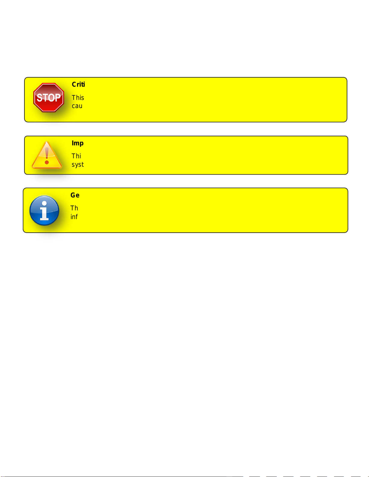
Critical Safety Information.
This symbol will be used critical information when failure to follow the instructions may
cause injury or death.
Important Information.
This symbol will be used when failure to follow the instructions may result in unexpected
system behaviour or impact system performance.
General Information.
This indicates general information which is provided for the purpose of additional
information.

Version: A.00 AgGuide V6 Operation Manual Page 4
TABLE OF CONTENTS
GENERAL INFORMATION...............................................................................................................................3
INTRODUCTION...............................................................................................................................................9
AgGuide V6 Options .............................................................................................................................................................9
GPS Guidance ....................................................................................................................................................................9
Auto-steer or FlexiSteer™...................................................................................................................................................9
Spray Control ......................................................................................................................................................................9
Variable Rate Control..........................................................................................................................................................9
Implement Steering.............................................................................................................................................................9
LevelGuide..........................................................................................................................................................................9
Other Information ................................................................................................................................................................9
GPS OVERVIEW.............................................................................................................................................10
GPS Accuracy......................................................................................................................................................................10
GPS Correction Signals......................................................................................................................................................10
Correction using Satellite or long distance land based stations .......................................................................................11
Local base stations ...........................................................................................................................................................11
Base Stations (local) .........................................................................................................................................................12
Base Stations (mobile)......................................................................................................................................................13
Community Base Stations.................................................................................................................................................14
COMPONENTS OF THE SYSTEM .................................................................................................................17
Display Terminals ...............................................................................................................................................................17
Wheel Angle Sensor ...........................................................................................................................................................17
SD Module............................................................................................................................................................................18
UniPOD.................................................................................................................................................................................18
Hydraulics............................................................................................................................................................................18
Nav Module..........................................................................................................................................................................18
GPS Receiver.......................................................................................................................................................................18
QUICK REFERENCE GUIDE..........................................................................................................................19
Selecting a Vehicle............................................................................................................................................................19
Selecting an Implement.....................................................................................................................................................19
Selecting a Job..................................................................................................................................................................19
Selecting Fields.................................................................................................................................................................19
Selecting Runlines ............................................................................................................................................................19
Recording Runlines...........................................................................................................................................................20
AutoSteering......................................................................................................................................................................20
AG GUIDE SOFTWARE .................................................................................................................................21

Version: A.00 AgGuide V6 Operation Manual Page 5
System Requirements ........................................................................................................................................................21
AgGuide Welcome Screen .................................................................................................................................................22
AgGuide Main Screen.........................................................................................................................................................23
Information Display Panel .................................................................................................................................................23
Guidance Display..............................................................................................................................................................24
Main Menu.........................................................................................................................................................................24
View Menu.........................................................................................................................................................................25
Record Menu.....................................................................................................................................................................27
Maps Menu........................................................................................................................................................................27
GPS Comms Menu ...........................................................................................................................................................28
Vehicle Menu.....................................................................................................................................................................28
Implement Menu ...............................................................................................................................................................29
Other Menu .......................................................................................................................................................................30
Exit Menu ..........................................................................................................................................................................30
USING CLIENT, FARMS AND FIELD DATA..................................................................................................31
Overview ..............................................................................................................................................................................31
Managing Client Data..........................................................................................................................................................32
Open the Clients Page......................................................................................................................................................33
Adding a new Client ..........................................................................................................................................................33
Renaming a Client.............................................................................................................................................................33
Importing a Client from AgGuide V4 .................................................................................................................................33
Deleting a Client................................................................................................................................................................33
Managing Farm Data...........................................................................................................................................................34
Open the Farms Page.......................................................................................................................................................35
Adding a new Farm...........................................................................................................................................................35
Renaming a Farm .............................................................................................................................................................35
Deleting a Farm.................................................................................................................................................................35
Managing Field Data ...........................................................................................................................................................36
Opening the Fields Page...................................................................................................................................................37
Adding a new Field............................................................................................................................................................37
Renaming a Field..............................................................................................................................................................37
Deleting a Field .................................................................................................................................................................37
Other Field Operations......................................................................................................................................................38
Exporting Shape File.........................................................................................................................................................38
Importing Shape Files .......................................................................................................................................................38
Setting the UTM Zone.......................................................................................................................................................38
Copying and Moving Records ...........................................................................................................................................39
Duplicating Client Records................................................................................................................................................40
Copying and Moving Records...........................................................................................................................................40
BOUNDARIES, HEADLAND PASSES AND RUNLINES................................................................................41
Boundaries...........................................................................................................................................................................41
Overview ...........................................................................................................................................................................41
Boundary Recorder Menu.................................................................................................................................................43
Boundary Recording Example ..........................................................................................................................................44
Opening the Boundary Recording Menu...........................................................................................................................45

Version: A.00 AgGuide V6 Operation Manual Page 6
Selecting the Recording Point...........................................................................................................................................45
Selecting the Boundary Type............................................................................................................................................45
Selecting Headland Line Recording Mode........................................................................................................................45
Recording Field Boundary.................................................................................................................................................46
Headland Passes.................................................................................................................................................................47
Overview ...........................................................................................................................................................................47
Headland Recording Menu ...............................................................................................................................................48
Headland Recording Example ..........................................................................................................................................49
Opening the Headland Recording Menu...........................................................................................................................50
Enabling / Disabling Headland Recording. .......................................................................................................................50
Setting the Required Number of Headland Passes..........................................................................................................50
Recording Headland Passes.............................................................................................................................................50
Runlines ...............................................................................................................................................................................51
Overview ...........................................................................................................................................................................51
Runline Generation Modes ...............................................................................................................................................52
Pivot Mode Recording.......................................................................................................................................................52
Runline Recorder Menu....................................................................................................................................................53
Opening Runline Recording Menu....................................................................................................................................54
Selecting AB Parallel Runline Recording..........................................................................................................................54
Recording AB Parallel.......................................................................................................................................................54
Selecting A+ Direction Recording .....................................................................................................................................54
Recording A+ Direction.....................................................................................................................................................55
Selecting Contour Recording............................................................................................................................................55
Recording Contour Runline...............................................................................................................................................55
Selecting Pivot Recording.................................................................................................................................................55
Recording Pivot Runline....................................................................................................................................................55
Advanced Operations.........................................................................................................................................................57
Enabling Simultaneous Recording....................................................................................................................................58
Selecting and Managing Runlines.....................................................................................................................................59
Runline Row Width and Offset..........................................................................................................................................60
Opening the Runlines Page ..............................................................................................................................................61
Selecting a Runline ...........................................................................................................................................................61
Renaming a Runline..........................................................................................................................................................61
Deleting a Runline.............................................................................................................................................................61
Copying a Runline within same Field................................................................................................................................61
Copying and Moving Runlines ..........................................................................................................................................62
Changing the Runline Row Width.....................................................................................................................................62
Changing the Runline Offset.............................................................................................................................................62
WORKING WITH JOBS..................................................................................................................................63
Overview ..............................................................................................................................................................................63
Opening the Jobs Page.....................................................................................................................................................64
Selecting an Existing Job..................................................................................................................................................64
Adding a new Job..............................................................................................................................................................64
Renaming a Job................................................................................................................................................................64
Deleting a Job ...................................................................................................................................................................64
Copying a Job within same Field ......................................................................................................................................65
Copying and Moving Jobs.................................................................................................................................................65
Other Job Operations........................................................................................................................................................66
Exporting Job Coverage Map............................................................................................................................................66
Exporting Job Trail ...........................................................................................................................................................66

Version: A.00 AgGuide V6 Operation Manual Page 7
Displaying Job Statistics ...................................................................................................................................................67
WORKING WITH PLANS................................................................................................................................67
Overview ..............................................................................................................................................................................72
Prescription Map.................................................................................................................................................................72
Adding Prescription Map...................................................................................................................................................72
Edit Prescription Map........................................................................................................................................................72
Using Prescription Map with Implement… ........................................................................................................................72
Level Guide Control Plans .................................................................................................................................................72
GPS CONFIGURATION..................................................................................................................................73
VEHICLE CONFIGURATION..........................................................................................................................73
Creating a Vehicle...............................................................................................................................................................73
Vehicle Dimensions ............................................................................................................................................................73
Vehicle GPS configuration.................................................................................................................................................73
Steering System Configuration .........................................................................................................................................73
WAS Calibration................................................................................................................................................................73
Nav Module Configuration.................................................................................................................................................73
Tuning ..................................................................................................................................................................................73
Troubleshooting..................................................................................................................................................................73
IMPLEMENT CONFIGURATION ....................................................................................................................74
Creating an Implement .......................................................................................................................................................74
Implement Dimensions.......................................................................................................................................................74
Implement GPS Configuration...........................................................................................................................................74
Configuring Bins and Tanks ..............................................................................................................................................74
Configuring Sections..........................................................................................................................................................74
Configuring External Controllers ......................................................................................................................................74
STEERING SYSTEM CONFIGURATION........................................................................................................74
Standard / Farmscan...........................................................................................................................................................74
Steering Wheel Motor .........................................................................................................................................................74
PVED CL...............................................................................................................................................................................74
AGCO/CAT Challenger M/T ................................................................................................................................................74

Version: A.00 AgGuide V6 Operation Manual Page 8
AGCO/Fendt Vario...............................................................................................................................................................74
CLAAS Lexion 770 ..............................................................................................................................................................74
CNH/ Austoft Tracked Hydraulic........................................................................................................................................74
LEVEL GUIDE ................................................................................................................................................74

Version: A.00 AgGuide V6 Operation Manual Page 9
INTRODUCTION
Congratulations on your purchase of AgGuide V6. This manual covers the use of the for visual guidance,
steering assist, spray control, GPS controlled land levelling or combinations of two or more of these options.
This manual and AgGuide application software can be used in conjunction with Farmscan Ag hydraulic
steering kits and GPS systems of varying accuracies. This purchase will almost certainly include a ruggedized
Windows based touch-screen computer (5900 PC are used for demonstration purposes in this manual), which
will become the central component of your AgGuide system.
This manual will cover all of the essential topics regarding the setup, operation, adjustment and
troubleshooting of your new system.
AgGuide V6 Options
GPS Guidance
AgGuide V6 can be used in conjunction with a suitable GPS receiver to provide visual guidance solutions to
the user. When used in this mode only, auto-steer and spray control functions are not available.
Auto-steer or FlexiSteer™
AgGuide V6 can be used to assist in steering of the vehicle when used in conjunction with a suitable kit
enabling secondary control over the steering. Once this option has been enabled, GPS guidance (as above) is
automatically available.
Spray Control
AgGuide V6 can be used to automate various aspects of the spray applications. This includes full variable rate
control of up to two parallel spray booms together with sectional boom control.
Variable Rate Control
AgGuide V6 can be used to automate various aspects of solid fertilizer and seed applications. This includes full
variable rate control of up to three application bins.
Implement Steering
AgGuide V6 can be used to assist in steering of implements when used in conjunction with a suitable kit
enabling control over the steering.
LevelGuide
AgGuide V6 can be used to assist in grading of fields using single plane or multi-plane cut-fill designs.
in grading of fields using single plane or multi-plane cut-fill designs.
Other Information
By selection of which of the above options are required at the time of purchase, you are able to use any or all
of the above functionality to best suit your application.
Options can be enabled later by contacting your nearest sales representative.

Version: A.00 AgGuide V6 Operation Manual Page 10
GPS OVERVIEW
GPS (Global Position System) is a generic term used to refer to a system that uses satellite constellations that
circle the earth to obtain a position on, or close to the earth’s surface.
This manual is not meant to provide a comprehensive description of the operation of GPS systems, however a
basic understanding will enable the user of the AgGuide V6 system to better understand and operate the
system.
GPS Accuracy
GPS accuracy is a much-maligned term. Over recent years, many suppliers have supplied their own
interpretation of the term, often to suit their commercial needs. Terms such as “Pass to Pass” accuracy may be
relevant where only short term accuracy is required, however it is often misleading to the new user and so, for
the purposes of this manual, we will refer to GPS accuracy as surveyors and other professional users of GPS
do.
GPS accuracy is traditionally split into three ranges. These are as follows
Sub-meter (defined as accuracies less than a meter but
greater than 15cm;
10cm (usually defined as accuracies between 10 and 15
cm this includes suppliers such as OmniSTAR HP &
Terrastar-D);
2cm (also referred to as RTK)
To further understand GPS accuracy, substitute the value of accuracy that you require e.g. 10cm for the value
shown as “R” in Diagram 1
The green circle represents the area in which your selected GPS will place you and still be within its design
parameters regardless of time elapsed.
e.g. In the example shown above using 10cm accuracy, the GPS will conform within its designed accuracy
provided that it gives a position within the 10cm (radius) 20cm (diameter) circle.
GPS Correction Signals
Standalone GPS, often referred to as autonomous GPS will only provide an accuracy (see above) of between
5 and 8 meters. For most applications using AgGuide V6, a better accuracy is required and therefore a
correction signal is needed to enhance the autonomous or stand alone accuracy.
Correction signals traditionally take two (generic) forms:
1.Satellite or long distance land based stations (10cm to 1M accuracy) or
2.Local base stations (2cm to10cm accuracy)
R
Diagram 1

Version: A.00 AgGuide V6 Operation Manual Page 11
Your supplier based on your requirements will make your selection of correction signal, however the following
may assist in understanding your system further.
Correction using Satellite or long distance land based stations
These signals are sometimes available free of charge such as those provided in coastal Australia (sometimes
called Marine Beacon signal), however traditionally in agricultural areas, it is necessary to subscribe to a
commercial alternative requiring an annual subscription such as the OmniSTAR system or Terrastar.
(Compatible hardware ONLY)
OmniSTAR & Terrastar offer both sub –meter (VBS) and 10cm (HP) correction signals and can be efficiently
received in most agricultural areas within Australia and NZ.
Local base stations
Using a local base station enables high accuracy correction without the need for annual subscription. This
must be offset by the capital cost of a base station. Traditional payback periods can vary between 2 and 7
years depending on selection criteria. This period can be further reduced by sharing a base station with
neighbours as one base can service many vehicles (rovers)
If you have selected a GPS system that requires a base station, the base will be set up by a Farmscan Ag
representative however some understanding of the system will ensure trouble free operation and also assist if
adjustments are to be made under the supervision of Farmscan Ag.
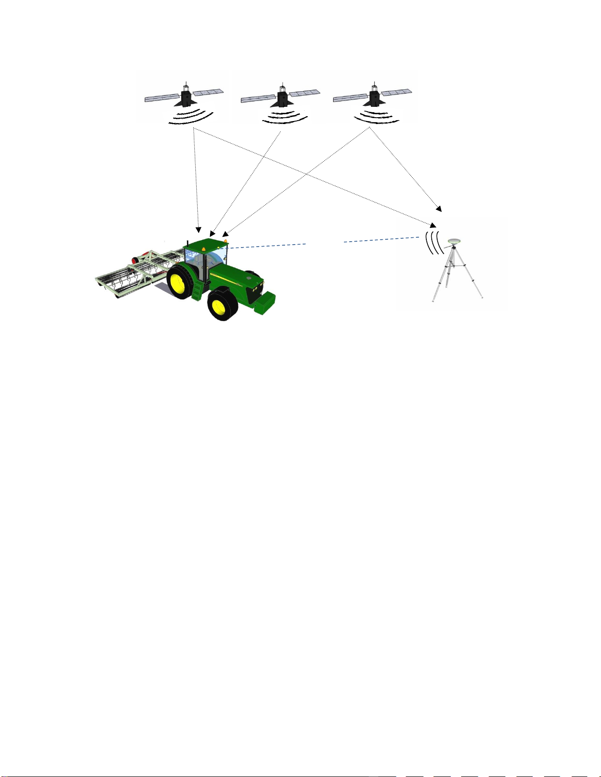
The basic RTK GPS system consists of two parts - a GPS base station and the vehicle GPS (sometimes called
a rover). It is essential that these components are setup correctly before configuring and operating AgGuide to
ensure the best possible performance.

Version: A.00 AgGuide V6 Operation Manual Page 12
Base Stations (local)
There are two types of base station - fixed and mobile.
A fixed base station is typically located in a high position such as a shed roof or property pole that has access
to mains power.
The base station GPS and base radio together with GPS antenna, radio aerial and cabling are housed in a
heavy duty case. With the addition of a tripod and a mobile power source (12volt battery) your fixed base
station can become mobile with minimal impact to your fixed base station setup.
Points to consider with fixed base stations:
1.Mounting the radio aerial as high as possible will get best possible performance
2.The GPS antenna must be mounted so that it has a clear 360° view of the horizon –any obstacles may
create performance problems (e.g. black spots)
3.When using a 2 Watt UHF radio, mount the UHF radio aerial and GPS antenna at least 2 metres apart
4.When using a 35 Watt UHF radio, mount the UHF radio aerial and GPS antenna at least 5 metres apart
5.If the Base Station is to be used for Land levelling, the distance between Base and Rover should be
limited to less than 5 km. Accuracy degrades with increasing distance from the Base.
Typical fixed base station located on
a shed roof, showing the GPS
antenna (1) and the Radio aerial (2)
Caution!
Do not apply power to the Base Station without being connected to an antenna as damage
to the Base may result.
1
2

Version: A.00 AgGuide V6 Operation Manual Page 13
Base Stations (mobile)
Contractors generally prefer a mobile base station as it allows them the freedom to move the base station from
farm to farm.
The GPS antenna can be attached preferably to a tripod but a post or star-picket can be used as long as the
GPS antenna is suitably secured.
Provided that the GPS antenna is returned to the exact position at a later time, accuracy will be maintained
year after year.
If a mobile base station has been ordered it will have a radio of less than 4W capacity.
If the Base Station is to be used for Land levelling, the distance between Base and Rover should be limited to
less than 5 Km. Accuracy problems occur as this distance increases.
Example of a mobile base station

Version: A.00 AgGuide V6 Operation Manual Page 14
Community Base Stations
Community base stations are collaborative fixed GPS base stations that are accessed by a group of farmers
that work their properties in the same area. They are typically set up by a co-operative of private farmers to
maximize GPS coverage and minimize cost.
Figure 1: Example of community base station network coverage
Version: A.00 AgGuide V6 Operation Manual Page 15
Overview of Local base station operation
Satellites send GPS data that is received simultaneously by both the GPS in the vehicle and the GPS in the
base station.
As the base station is fixed and has been given an accurate or calculated ‘fix’, the calculated variation
(correction) from this position is transmitted via radio to the vehicle GPS which then calculates the corrected
position of the vehicle.
Correction data is usually transmitted via radio once per second and the vehicle GPS uses this data to
calculate the position of the vehicle every ⅕th of a second (5Hz).
For land levelling, the implement GPS can be set to calculate the position of the implement blade every 1/10th
of a second (10Hz).
Tractor including Rover
GPS powered by
AgGuideV6
GPS Base
Station
RADIO

Version: A.00 AgGuide V6 Operation Manual Page 16
Base Station
The GPS base station provides the correction signal (see GPS Correction Signals above) to the GPS
receiver in the vehicle.
Tractor GPS (Rover)
The Rover GPS receives the corrected signal information from the GPS Base Station via the base radio
as shown in the diagram on the next page.
This then enables the Rover GPS to pinpoint the position according to the receivers’ accuracy.
This positioning information is the used by the AgGuide software, to deliver the guidance, auto steer or
spay control functions of the system.
AgGuide V6
This is the latest version of the Windows based software that controls your tractor and manages all of
your customized farm specific data including farms, fields and boundaries.
It calculates and translates the GPS positioning data allowing you to enjoy the benefits of high accuracy
steering and spray control.
Satellites send data that is received simultaneously by both the GPS in the vehicle and the GPS in the base
station.
As the base station is fixed and has been given an accurate or calculated ‘fix’, the calculated variation
(correction) from this position is transmitted via radio to the vehicle GPS which then calculates the corrected
position of the vehicle.
Correction data is usually transmitted via radio once per second and the vehicle GPS uses this data to
calculate the position of the vehicle every ⅕th of a second (5Hz).
For land levelling, the implement GPS can be set to calculate the position of the implement blade every 1/10th
of a second (10Hz).

Version: A.00 AgGuide V6 Operation Manual Page 17
COMPONENTS OF THE SYSTEM
Display Terminals
The AgGuide V6 software requires a touch-screen Windows®based PC, which is generally included as part of
your purchase. It is mounted in the cab of the vehicle during operation and can be moved between a fleet of
vehicles as required.
Wheel Angle Sensor
OR
The Wheel Angle sensor is an integral part of the auto steer system and will need to be both fitted and
commissioned correctly for the system to operate.
Its prime job is to define accurately to the AgGuideV6 system, exactly where the wheels or articulation point of
the vehicle is at any time. This feedback is critical to the effective operation of the system and periodic checks
should be made to ensure it’s correct calibration.
Example of xLite 5700 tablet
Example of xPRO 5800 DLI tablet
Version: A.00 AgGuide V6 Operation Manual Page 18
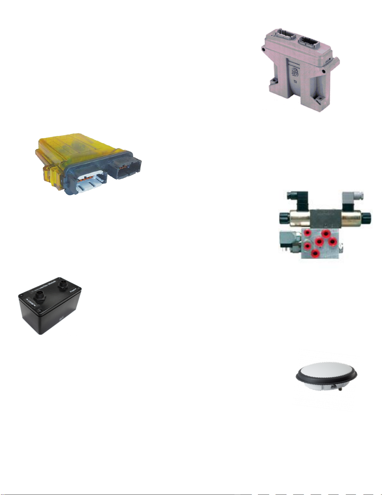
SD Module
The SD module provides the interface that enables the brains of the
AgGuide system (PC and AgGuide software) to talk effectively with the
remote components on the vehicle.
These components, such as Wheel Angle Sensor, Navigation Module (not
fitted to all vehicles) provide information to the PC or others such as
Hydraulic Control valves, accept control decisions from the PC via the SD
module.
UniPOD The Farmscan Ag UniPOD is the newest multipurpose and purpose
built interface on the market today. The UniPOD can be pre
programmed for Spray Control, Seeder Control, Spreader control,
Steering & levelling control.
Hydraulics
For Hydraulic Steering and some implement control applications additional
Hydraulic control valves may be fitted to the vehicle or implement. Valve
components will be dependent on the Vehicle and implement type.
Nav Module
The Nav module is an integral component of the Steering system and provides sensor
information regarding the vehicle movement including roll, pitch and yaw. This
information is used to correct the GPS ground position.
GPS Receiver
The GPS receiver provided the GPS position information to the system. When a
correction solution is available , the GPS Receiver provides the corrected GPS data to
the system.
Version: A.00 AgGuide V6 Operation Manual Page 19
QUICK REFERENCE GUIDE
The following provides a quick reference for common tasks for operators who are familiar with AgGuide.
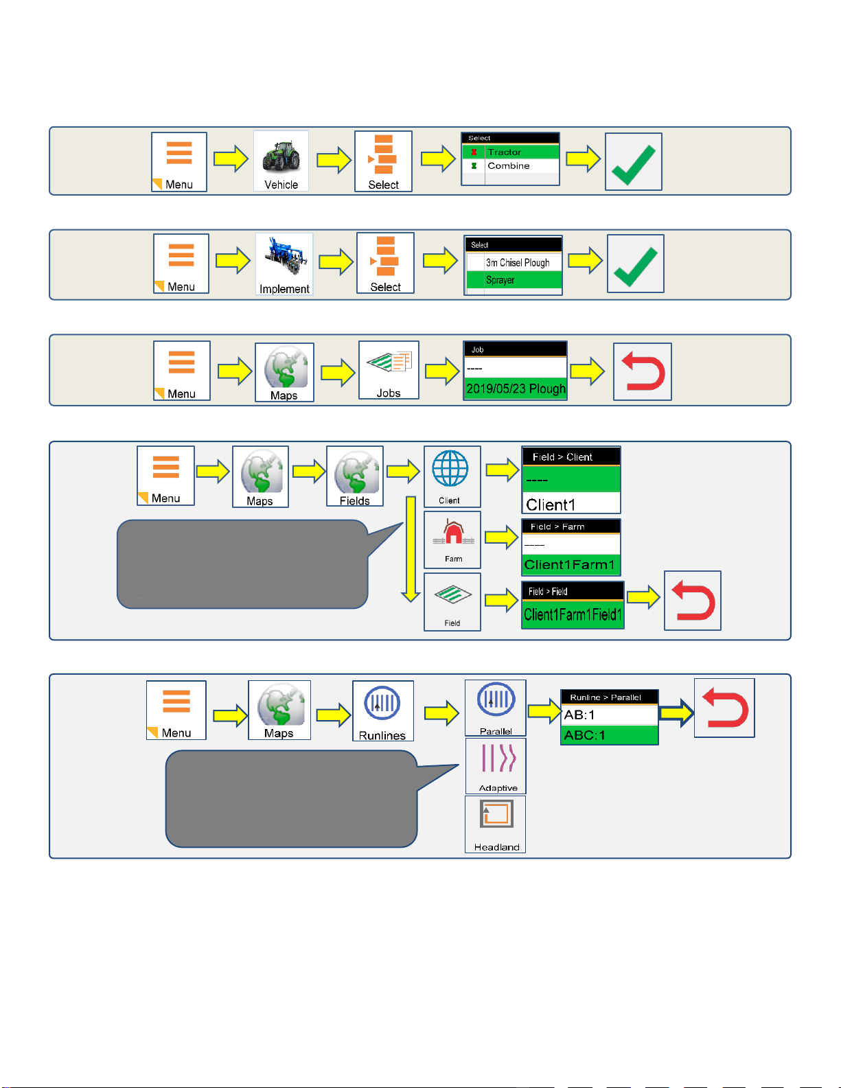
Selecting a Vehicle
Selecting an Implement
Selecting a Job
Selecting Fields
Selecting Runlines
Fields can be filtered by Client and
Farm selection on the Fields tab
menu. Only Fields associated with
the selected Client or Farm will be
displayed.
A field can contain multiple runlines.
Each of the runline types can be
viewed and selected from the
Runlines Tab menu.

Version: A.00 AgGuide V6 Operation Manual Page 20
Recording Runlines
Auto Steering
Adjusting Steering Gain
Adaptive and Pivot
Runlines
Select Runline.
Runline will be
displayed on Screen.
The Green line indicates
the destination path
based on vehicle
position.
When the line is not able
to be engaged due to
speed or approach angle
the Auotsteer button will
be red and Autosteer
cannot be activated.
When the system is
Ready To Engage (RTE)
the Autosteer button will
change to orange, and
Autosteer can be
activated.
Selecting the Steering button will display
the Steering Gain Page. Increasing the
Gain will cause the Steering to be more
aggressive, decreasing the Gain will
cause the steering to be more relaxed.
Important Information.
Using high Steering Gain at higher operating speeds may result in undesirable steering
performance.
Table of contents
Other Precision Automobile Accessories manuals


Popular Automobile Accessories manuals by other brands

Directechs
Directechs 933.CHRYSLER6 installation guide

COMTRUK
COMTRUK SUB Operation manual

Soundoff Signal
Soundoff Signal PMP1BKUMB4 Series quick start guide

Fiamma
Fiamma HYMER ADAPTER KIT 02 Installation and usage instructions

COBB Tuning
COBB Tuning AccessPORT Getting started

Tuff Tonneaus
Tuff Tonneaus 11303 FITTING INSTRUCTION

GReddy
GReddy e-manage ultimate installation manual

Autosaver 88
Autosaver 88 YA0101A009 manual

Hollywood
Hollywood Baja Bicycle Carriers B2 installation instructions

Free2Move eSolutions
Free2Move eSolutions PowerMeter Installation and user manual

Reese
Reese Sidewinder 61302 installation instructions

Jaeger
Jaeger 21060578 Fitting instructions


