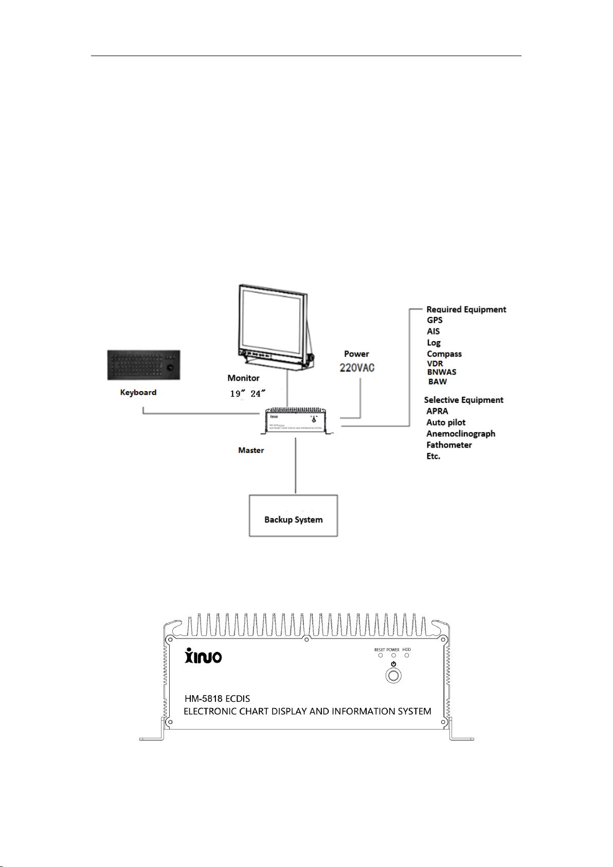
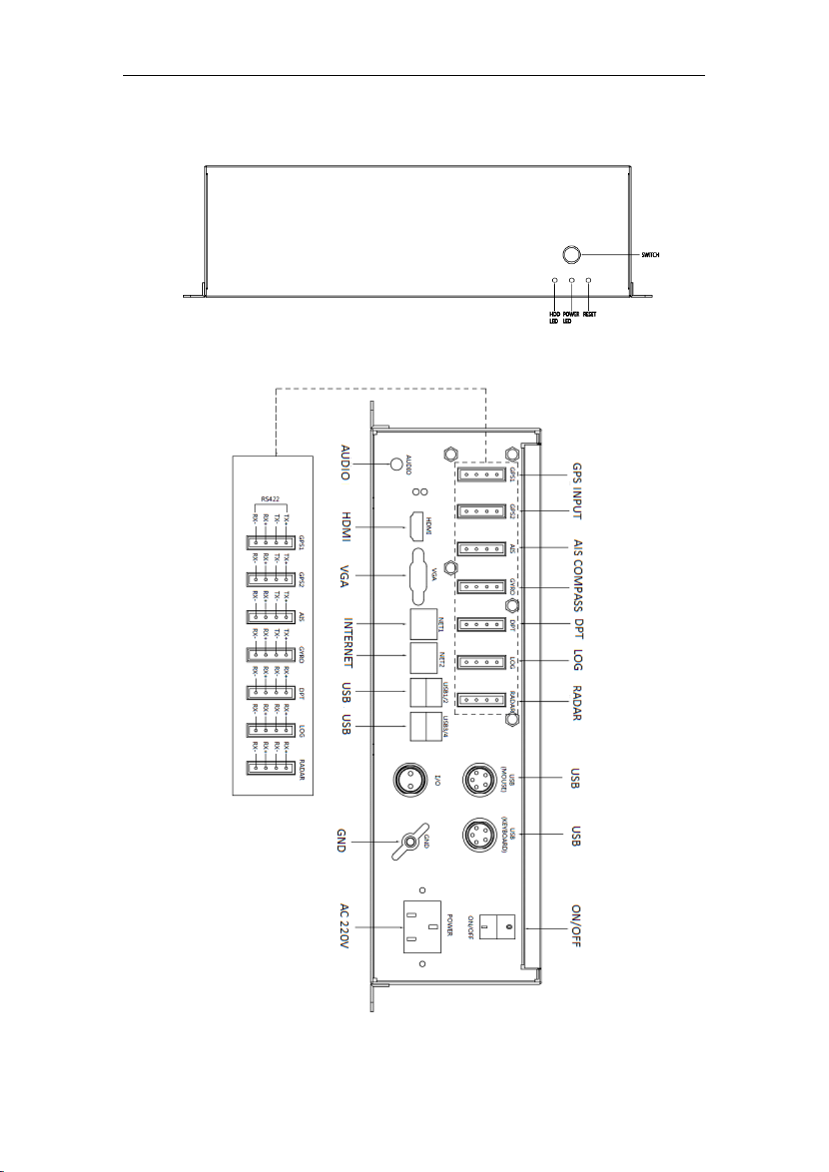
Xinuo HM-5818 User manual

ECDIS (Electronic Chart Display and Information System)
◆HM-5818( 19”24” )
User Manual
©1996-2020. Xinuo Information Technology (Xiamen) Corporation Limited

ECDIS User Manual
1
User Instructions:
Copyright.
Unless hereby stated, no part of this manual can be reproduced, printed, copied, sent,
disseminated, downloaded or stored on any media without prior written authorization of
Xinuo Information Technology (Xiamen) Corporation Limited. As permitted by Xinuo
Information Technology (Xiamen) Corporation Limited, simplified copies of this manual
can be downloaded to hard disks or other electronic media for browsing, or this manual
and its revisions can be printed. The ownervessel of copyright shall be specified in all
reproductions. This manual or any of its revisions is prohibited from being used for
commercial purposes.
This manual is subject to change without notice. You can get the updates and the
information on how to use or operate this product and others from www.xinuo.com, the
website of Xinuo Information Technology (Xiamen) Corporation Limited.
Warning: Please read the notes of this manual carefully to know about safety statements
and other important information of products.
Declaration: All words like “Xinuo” and “Xinuo Hangke” mentioned here below
refer to as “Xinuo Information Technology (Xiamen) Corporation Limited”.
Note: This set of equipment shall not be directly used for navigation.
In practices, please use the equipment in combination with other navigation equipment
and actual marine conditions such as paper chart, portable beacon, radar, tide,
hydrological conditions and weather.
Declaration: Names of other products and companies mentioned in this user manual are
only used for identification. They possibly belong to registered trademarks or copyrights of
other companies.
Names and versions of software are just displayed on a display, but not described in this
manual in detail.
Explanation of the mark used in this manual:
【】: Titles of quoted menus. For example, 【Basic Menu】is the basic menu called from
a system.

ECDIS User Manual
2
Notes:
Before starting the vessel borne navigation equipment, be sure to read following notes
carefully to avoid product failures arising from improper operation:
1. Please don’t place the vessel borne navigation equipment at random without
fastening, in order that the equipment won’t be severely damaged when it falls off
because of tossing or other factors during the navigation.
2. Please don’t use any other power adapter which is not equipped for this product, or
else the vessel borne navigation equipment would fail to work for differences in circuit
design, or its performances would be affected, and the machine would be even
damaged. The voltage of this machine must be AC 220V, and must not go beyond
this range.
3. Please don’t dismantle the vessel borne navigation equipment, or else you will be
unable to enjoy the free warranty services if the vessel borne navigation equipment is
dismantled by yourself instead of a maintenance engineer authorized by our
company.
4. In operating or cleaning the vessel borne navigation equipment, avoid any liquid or
other objects falling off inside the equipment, in order not to cause damages to circuit
or a short circuit.
5. Please don’t place the vessel borne navigation equipment and its accessories in
damp areas or have them directly exposed to sun. The machines shall be operated
under dry conditions.
6. The power supply shall be reliably grounded to avoid static electricity and lightning
strike. If the instrument is not used for the time being, please switch the power supply
off.
7. When the vessel borne navigation equipment fails to position for a long while, please
check if the antenna is properly installed, poorly connected, sheltered or disturbed by
other things around it. GPS antenna is active, so please make sure its cable joints are
intact without short or open circuits before starting the vessel borne navigation
equipment. Then, install the antenna correctly. When the equipment is under
operation, the antenna shall not be pulled out at will, to protect the equipment from
damage.
8. In case of over high external temperature, the vessel borne navigation equipment
would crash. In this case, please shut down it for the time being, and restart it when it
is restored to the normal temperature.
9. When LCD (Liquid Crystal Display) is used, it shall not be directly exposed to the
sunshine, and its angle of elevation may be adjusted anytime for optimal visual
effects.
10. In case of any hardware failure (e.g. burnt out power cord, damaged casing or foreign
bodies falling inside the machine), please power the machine off and contact the
distributor immediately.
11. Our company shall not be liable for any legal and other responsibilities arising from
any marine accidents, financial or profit losses of vessel s equipped with out vessel
borne navigation equipment.

ECDIS User Manual
3
Content
User Instructions:...........................................................................................................1
Notes: ..............................................................................................................................2
Content............................................................................................................................3
Chapter 1.........................................................................................................................6
1.1 Product Descriptions ........................................................................................ 7
1.1.1 Hardware Components ........................................................................ 7
1.1.2 Host Interfaces ..................................................................................... 7
Chapter 2.......................................................................................................................10
2.1 Home Screen.................................................................................................. 11
2.1.1 Description of Operational Interface................................................... 11
2.1.2 Quick Operation Menu ....................................................................... 13
2.2 Route design .................................................................................................. 18
2.2.1 New route........................................................................................... 18
2.2.2 Editing waypoints ............................................................................... 18
2.2.3 Deleting waypoints ............................................................................. 19
2.2.4 Locking the route................................................................................ 19
2.2.5 Deleting a route.................................................................................. 19
2.2.6 Display Settings ................................................................................. 20
2.2.7 Route detection .................................................................................. 20
2.2.8 Loading the route ............................................................................... 21
2.2.9 Save the route.................................................................................... 21
2.2.10 List of waypoints............................................................................... 22
2.2.11 Voyage schedule .............................................................................. 23
2.2.12 Route Export/Import ......................................................................... 25
2.2.13 Interaction Log ................................................................................. 25
2.2.14 Settings ............................................................................................ 26
2.3 Route monitoring ............................................................................................ 27
2.4 Electronic chart management ......................................................................... 28
2.4.1 Chart unit ........................................................................................... 29
2.4.2 Unit License ....................................................................................... 29
2.4.3 Update log.......................................................................................... 30
2.4.5 Data Service Provider ........................................................................ 30
2.5 Manual update................................................................................................ 30
2.5.1 New object ......................................................................................... 31
2.5.2 Deleting objects.................................................................................. 31

ECDIS User Manual
4
2.5.3 Moving objects ................................................................................... 32
2.5.4 Correcting the object .......................................................................... 33
2.5.5 Manually updates ............................................................................... 33
2.6 Mariners’ feature............................................................................................. 33
2.7 Mariners’ Note ................................................................................................ 35
2.8 Navigation record ........................................................................................... 35
2.9 AIS Information ............................................................................................... 36
2.9.1 AIS List ............................................................................................ 37
2.9.2 Messages........................................................................................... 37
2.9.3 AIS Settings ....................................................................................... 37
2.9.4 AIS navigation parameter settings...................................................... 38
2.10 Radar target.................................................................................................. 38
2.11 ECDIS chart 1............................................................................................... 39
2.12 Settings......................................................................................................... 39
2.12.1 OwnShip setting ............................................................................... 39
2.12.2 System Settings ............................................................................... 41
2.12.3 Chart setting..................................................................................... 43
2.12.4 Sensor Settings................................................................................ 48
2.12.5 Alarm Settings .................................................................................. 49
2.12.6 Network Settings .............................................................................. 51
2. 13 Alarm ........................................................................................................... 51
2.13.1 Overview .......................................................................................... 51
2.13.2 Alarm prompts and responses.......................................................... 52
2.13.3 Alarm Record ................................................................................... 52
2. 14 LOP positioning ........................................................................................... 53
2.14.1 Overview .......................................................................................... 53
2.14.2 How to use ....................................................................................... 54
2.15 Distance and position calculation ................................................................. 56
2.15.1 Distance calculation ......................................................................... 56
2.15.2 Position calculation .......................................................................... 56
2.16 Standard Legend .......................................................................................... 56
Chapter 3.......................................................................................................................58
3.1 Summary............................................................................................... 59
3.2 View Chart Information ................................................................................... 59
3.3 Chart Sequencing........................................................................................... 59
3.4 IHO S-63 Data Protection Solution ................................................................. 59

ECDIS User Manual
5
3.5 SA Certificate.................................................................................................. 59
3. 5.1 Installation of SA Certificate .............................................................. 60
3.5.2 Uninstall SA Certificate....................................................................... 61
3.6 User permit ..................................................................................................... 61
3.6.1 Generate User Permit ........................................................................ 62
3.7 Data Service Providers ................................................................................... 62
3.8 Cell permit ...................................................................................................... 62
3.8.1 Install Cell Permit ............................................................................... 63
3.8.2 Uninstall Cell Permit........................................................................... 64
3.9 Electronic Chart Cells ..................................................................................... 64
3.9.1 Install Exchange Set .......................................................................... 65
3.9.2 Install Map (S-57 Electronic Chart) .................................................... 68
3.9.3 Uninstall electronic chart .................................................................... 68
3.9.4 Update log.......................................................................................... 69
Chapter 4.......................................................................................................................70
4.1 Equipment maintenance ................................................................................. 71
4.2 Operation Manual for HM-5818 Update Disk.................................................. 72
4.2.1 Select boot device (If the default boot device is USB flash disk,you can
skip this step) .............................................................................................. 72
4.2.2 Function Options ................................................................................ 73
4.2.3 Update application ............................................................................. 73
4.3 Operation manual for HM-5818 system rescue .............................................. 74
4.3.1 Select boot device.............................................................................. 74
4.3.2 Function Options ................................................................................ 75
4.3.3 General Recovery .............................................................................. 76
4.3.4 Advanced Options .............................................................................. 77
Annex I: Mounting Dimensions of Host ....................................................... 78
Mounting Dimensions of Display(19inch): ................................................... 78
Mounting Dimensions of Display(24inch): ................................................... 79
Annex 2: ............................................................................................................... 80
Specifications and Standards...................................................................... 80

ECDIS User Manual
6
Chapter 1
Overview
In this chapter, an introduction is made to product appearances, accessories
and keyboards.

ECDIS User Manual
7
1.1 Product Descriptions
HM-5818(19´24´) Electronic Chart Display and Information System (ECDIS) is controlled
by the host and composed according to structures of displays with different size, to make
it convenient to install the system and meet the needs for different display size. Its
software system is operated on an open platform known as Linux, designed with
functional modules. Being stable and convenient for operation, it has a simple and clear
human machine interface that can meet users’ requirements.
1.1.1 Hardware Components
1.1.2 Host Interfaces
Model 1 :

ECDIS User Manual
8

ECDIS User Manual
9
Model 2:

10
Chapter 2
Operation and Setting
This chapter will guide you to gradually become familiar with system operation
and setting.

ECDIS User manual
11
2.1 Home Screen
2.1.1 Description of Operational Interface
1.Time display
Setting the time by GPS. When there is no GPS signal, the user can adjust the time and
time zone of the device to adjust the time. You can switch between world time and local
time by clicking the time display button
2.Data information and standard abbreviation
HDG: Heading of the vessel . The COG to the right of the HDG can also display GYRO.
STW: The speed of water.
COG: Heading to the ground.
SOG: Speed to ground.
Wind speed: wind speed
Direction: Wind direction
Wind: A source of data for aerovane, wind direction and wind speed.
DPT: Depth of water.

ECDIS User manual
12
LOG: Compass.
GYRO: Gyro.
DPT: depth sounder
RADAR: Radar
POSN GPS1: Position coordinates. GPS1 is the source of the signal.
WGS 84: Benchmark
3.Cursor information
4.Display scale
5.Navigation monitoring
Display basic information about route monitoring.
Route Name: Displays the name of the currently monitored route.
Yaw distance: The distance the vessel exceeds the safe distance and there is an alarm.
Yaw angle: shows the course of the vessel
Distance from the monitoring point: the distance from the vessel to the monitoring point.
Current monitoring point: The waypoint number and the waypoint name that the vessel
is about to arrive.
Next monitoring point: the next arriving waypoint number and the waypoint name of the
vessel .
Safety distance: According to the system settings, the user-defines safety distance .
Estimated arrival time(ETA): The estimated time it takes for the vessel to reach the
upcoming monitoring point.

ECDIS User manual
13
Total time remaining: The time it takes for the vessel to arrive at the destination.
Total remaining voyage: The remaining voyage at the end of the vessel .
Planned speed: Shows the speed of use based on calculations in the voyage plan.
Planned heading: Shows the current course of the vessel based on the route.
Planned Turning Radius: Shows the turning radius of the vessel at the monitoring point.
Planned Steering Rate: The number of angles per second, calculated from the predicted
speed and steering radius.
2.1.2 Quick Operation Menu
Center Own-vessel position
Click , show current vessel position on the chart.
Up mode
Click , then North Up can be chosen.
Zoom up the chart: click to zoom up the chart.
Zoom in the chart: click to zoom in the chart.
Distance measurement
By clicking , distance and azimuth between any two or more points can be
measured.
Measuring the distance from the mouse click, you can measure the distance and
orientation between any two or more points. Each point position information box displays
the coordinates, the orientation and distance of the major circle and the constant line from
the previous point. Among them, the RL data represents the lateral line orientation and
distance; the GC data represents the orientation and distance of the large circle route.
Electronic bearing line\active distance circle
With a mouse click ,you can quickly choose in a vessel -centric mode or free-moving

ECDIS User manual
14
mode.
Select ,centered on the vessel 's position, as shown below:
The specific information is displayed in the function window, as shown below.
You can edit and modify the electronic bearing line by clicking the button on the
window .The distance, azimuth, and reverse azimuth of the "relative
center point" can be set manually.。
Select ,the center point position is free to choose, the other
operations are the same as above.
The specific information is displayed in the function window as shown below.

ECDIS User manual
15
You can edit and modify the electronic bearing line by clicking the button
on the window. The distance, azimuth, and reverse azimuth of the
"relative center point" can be set manually.
Display mode
Click ,display mode switches in day 、cloudy 、night mode 。
AIS displays
Click ,you can quickly switch on/off to display the AIS vessel on the chart.
Display chart
Click ,The chart shows a mouse click and you can quickly switch to the chart
standard display.
Alarm list
Click ,you can quickly view history alarm。

ECDIS User manual
16
signal detection
Click , checks the status of the external signal access signal.
When the signal status bar is green, the signal is normal, as shown in the figure:
When the signal status is yellow, the signal is abnormal, as shown in the figure:
System information
Click ,check the system information, including system version and chart version.
The date of the chart update should be sorted and viewed in the release date of the chart
management.

ECDIS User manual
17
MOB
Click ,record a MOB position of the emergency landing point basing on the
current position.
The radar switch
Click , you can quickly switch the radar icon display function. Light means the
radar icon is turned on.
Shortcut menu switch
Click ,quickly open and close the shortcut menu.
Turn off the system
Click ,turn off the system.

ECDIS User manual
18
2.2 Route design
2.2.1 New route
Click "New Route", move the cross cursor, click the left button to add a waypoint, and right
click to end the route design. After adding the waypoints required for the route, click on
the menu "Save Route" button to save the newly created route. As shown below:
In the route editing area, you can view the information of the waypoints in the route,
including the total number of waypoints, name, latitude and longitude, range type, range,
safety distance, steering radius and other parameters can be edited.
In the route editing area, select a waypoint and click the right mouse button to “insert
waypoints” or “delete waypoints”.
Double-click the route name to edit the name of the route.
2.2.2 Editing waypoints
Click the "Edit Waypoint" button, the mouse will automatically jump to the chart center,
and enter the edit waypoint state.
Click the waypoint 1 on the route, move the cursor, and click the left button. The waypoint
1 is moved to the specified position of the cursor, and the right button is clicked to cancel
the move. To re-select the waypoint, click the “Edit Waypoint” button, re-select the

ECDIS User manual
19
waypoint, click the left button, the waypoint is moved to the specified position of the cursor,
right click to exit the edit waypoint operation. You can save the edited route by clicking
the menu "Save Route" button. Click the left button above the route segment between
the two waypoints to insert the waypoint. When you need to insert the waypoint at a
position other than the route segment, you can first insert the waypoint on the route
segment and then move the cursor to the desired insertion. position.
2.2.3 Deleting waypoints
Click the “Delete Waypoint” button, the mouse will automatically jump to the chart center.
At this time, enter the delete waypoint point, select the waypoint to be deleted, click the
left button, and the selected waypoint will be deleted. The waypoint number following the
deleted waypoint is changed and numbered sequentially. Right-click to exit the status to
delete the waypoint and click the “Save Route” button to save the edited route.
2.2.4 Locking the route
Click the “Lock Route” button, the currently selected route will be fully displayed in the
center of the chart at the maximum scale. Before the route is locked, as shown in the
figure:
2.2.5 Deleting a route
Click the “Delete Route” button to pop up the route list as shown below:
Table of contents
Other Xinuo GPS manuals