CHYNA SEA VENTURES ZENSTAR III User manual
ZENSTAR III
GPS Receiver
User’s Guide
CHYNA SEA VENTURES LTD.
WWW.ZENSTARGPS.COM

TABLE OF CONTENTS
1. Introduction..…..……………………………………….…………. 4
1.1 Overview…………………..…………………………………... 4
1.2 Features……………..…………………………………………. 5
1.3 Technical Specifications………………………………………. 6
2. Operational Characteristics………………………………………. 7
2.1 Initialization setup……………………………………………… 7
2.2 Navigation……………………………………………………….8
A. Appendix A Software Protocol…………………………………… 9
A.1 NMEA transmitted message…………………………………... 9
B. Appendix B Coordinate System and Output Settings…………… 17
B.1 Coordinate system……………………………………………. 17
B.2 Output settings……………………………………………….. 17
ZENSTAR III USER’S GUIDE

3
Usage Notice
Please read before using the GPS receiver:
¾GPS(Global Position System) is operated by the US Department of
Defense. The Organization is responsible for accuracy and
maintenance of the system with full authority. Any change made by
the organization will affect accuracy and function of GPS.
¾For your driving safety, we strongly suggest that you do not
operate the device during driving.
¾If you are inside a building, tunnel or near large structures while
navigating, it will affect GPS satellite signal receiving. At this time,
this device will have poor positioning capability.
¾If you have a radar detector in your car, this will interfere with signal
reception. If this situation happens, it is recommended to discontinue
using your radar detector.
¾Please do not expose this device to sunlight for extended
periods to avoid damage to the internal precision circuit.
ZENSTAR III USER’S GUIDE

4
Introduction
1.1 Overview
The ZENSTAR III Smart GPS Receiver is a complete GPS receiver, designed
with SiRF Star III Architecture. This positioning application meets strict
needs such as car navigation, mapping, surveying, security, agriculture and
others. Only a clear view of sky and a certain power supply are necessary to
the unit. It communicates with other electronic utilities via compatible dual-
channel through the USB connector and saves critical satellite data with
built–in backup memory. With low power consumption, the ZENSTAR tracks
up to 20 satellites at a time, re-acquires satellite signals in 100 ms and
updates position data every second. Trickle-Power allows the unit to operate
a fraction of the time and Push-to-Fix permits user to have a quick position
fix even when the receiver usually stays off.
ZENSTAR III USER’S GUIDE

5
1.2 Features
ZENSTAR III provides a host of features for easy integration and use.
1. High performance receiver tracks up to 20 satellites.
2. High sensitivity(-159 dBm) for indoor fixes. The SiRFstarIII GPS module can
acquire in only seconds even at low signal levels. As part of SiRF's patented
multi-mode GPS, the SiRFstarIII GPS module can track signal levels as low as -
159 dBm. The SiRFstarIII supports real-time navigation in urban canyons as
well as high sensitivity acquisition needed for indoor environments.
3. Differential capability utilizes real-time RTCM corrections producing 1-5
meter position accuracy.
4. Compact design ideal for applications with minimal space.
5. A rechargeable battery sustains internal clock and memory. The battery is
recharged during normal operation.
6. Optional communication levels, RS-232 and TTL.
7. LED display status: The LED provides users visible positioning status. LED
“ON” when power connected and “BLINKING” when ZENSTAR has positioned.
8. Built-in WAAS Demodulator.
9. Water proof design.
ZENSTAR III USER’S GUIDE

6
1.3 Technical Specification
USB connector:
The ZENSTAR is equipped with a USB A Type connector. The function
definition is as follows:
1.3.2 Environmental Characteristics
1)Working Temperature: -40~+85°C
2) Storage temperature: -40 ~85°C
3) Humidity:95%
1.3.3 Electrical Characteristics
1) Input voltage: +3.3~+5.2V DC
2) Backup battery: +3.0 DC (Inner Rechargeable Lithium battery.)
1.3.4 Performance
1) Tracks up to 20 satellites.
2) Update rate: 1 second.
3) Acquisition time (average)
Hot start: <1 second(open sky)。」
Cold start: <48 second(open sky)。」
4) Position accuracy:
Position: <10m 90% no SA
Velocity: 0.1 m/sec no SA Time: 1 second synchronized GPS time
5) Dynamic Conditions: Altitude: 60,000 ft max Velocity: 515 m/sec (1,000
knots) max Acceleration: 4G max
1.3.5 Interfaces
1) Dual channel TTL compatible level, with user selectable baud rate (4800-
Default, 9600, 19200, 38400)
2) NMEA 0183 Version 3.01 ASCII output (GPGGA, GPGSA, GPGSV,
GPRMC, option GPGLL,GPVTG).
ZENSTAR III USER’S GUIDE

7
Operational Characteristics
2.1 Initialization Setup
After the initial self-test is complete, the ZENSTAR III will begin the process
of satellite acquisition and tracking. The acquisition process is fully automatic
and, under normal circumstances, will take approximately 48 seconds to achieve
a position fix (38 seconds if ephemeris data is known). After calculating a
position fix, valid position and time information will be transmitted over the
output channel(s).
The ZENSTAR utilizes initial data such as last stored position, data and time as
well as satellite orbital data to achieve maximum acquisition performance. If
significant inaccuracy exists in the initial data, or if the orbital data is obsolete, it
may take a long time to achieve a navigation solution. The ZENSTAR Auto-locate
feature is capable of automatically determining a navigation solution without
intervention from the host system. However, to improve acquisition
performance, initialize the ZENSTAR with the host system if one or more of the
following events occurs: 1) The GPS receiver is not in use for more than 3
months or transportation over distances further than 500 kilometers. 2) Failure of
the external memory battery without system standby power.
ZENSTAR III USER’S GUIDE

8
2.2 Navigation
After the acquisition process is complete, the ZENSTAR will begin sending
valid navigation information over its output channels. This data includes:
1) Latitude/longitude/altitude
2) Velocity
3) Date/time
4) Error estimates
5) Satellite and receiver status
ZENSTAR III USER’S GUIDE
9
Appendix A Software Protocol
The protocol of the ZENSTAR GPS design is based on NMEA (National
Marine Electronics Association) 0183 ASCII format. The full protocol is
defined in “NMEA 0183, Version 3.01” and “RTCM (Radio Technical
Commission for Maritime Services), Recommended Standards For
differential Navistar GPS Service, Version 2.1, RTCM Special Committee
No.104.”
A.1 NMEA Transmitted Message
The ZENSTAR GPS receiver uses FirstGPSTM as the core, and
outputs a NMEA-0183 standard format message. The default
communication parameters for NMEA output are 4800 baud, 8 data
bits, stop bit, and no parity.
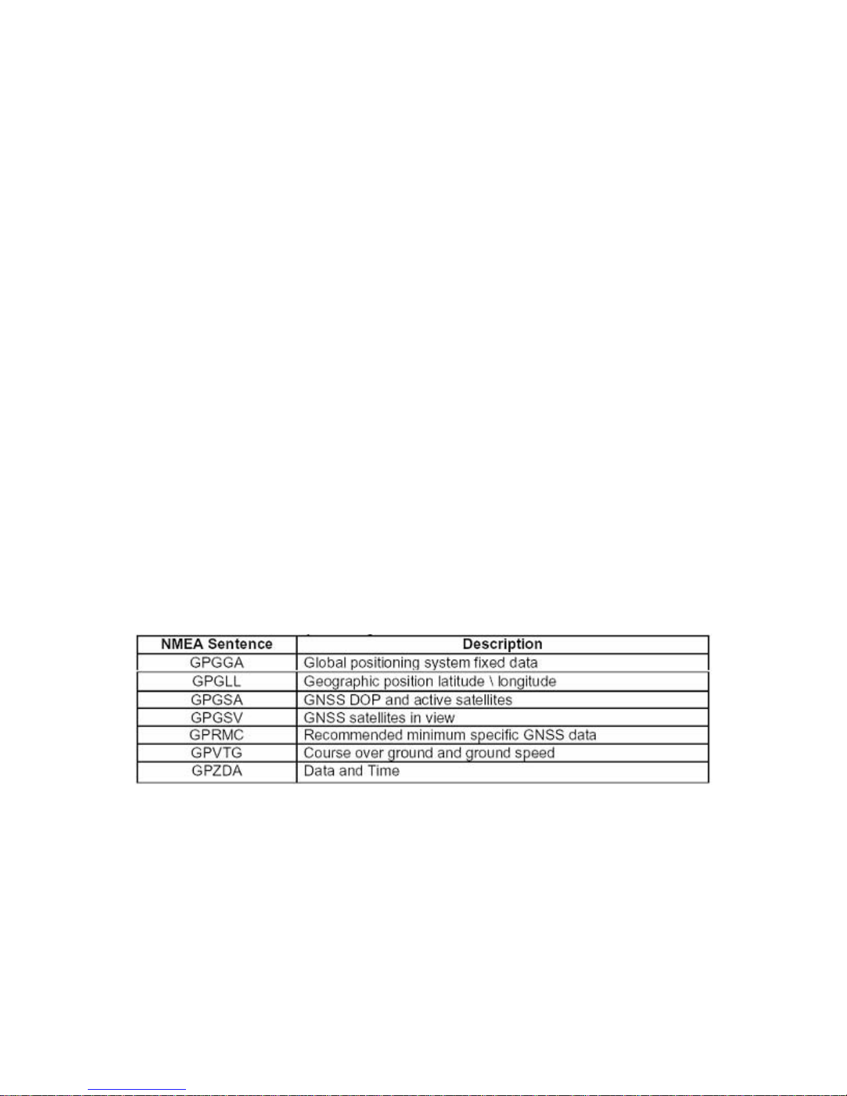
Table A-1 NMEA-0183 Output Messages
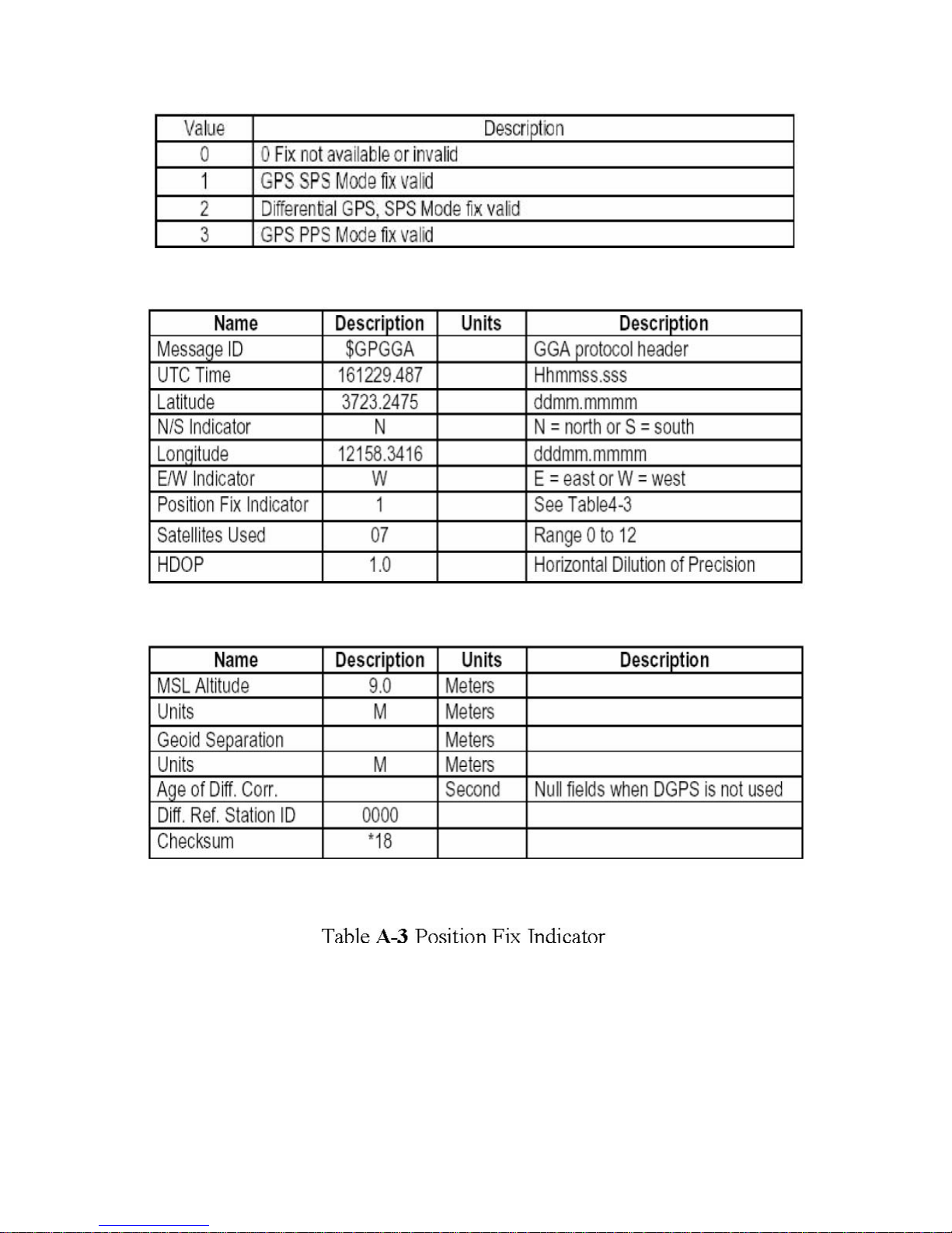
A.1.1 Global Positioning System Fix Data (GGA)
Samples:$GPGGA,161229.487,3723.2475,N,12158.3416,W,1,07,1.0,9.
0,M, , , ,0000*18
ZENSTAR III USER’S GUIDE
10
ZENSTAR III USER’S GUIDE
11
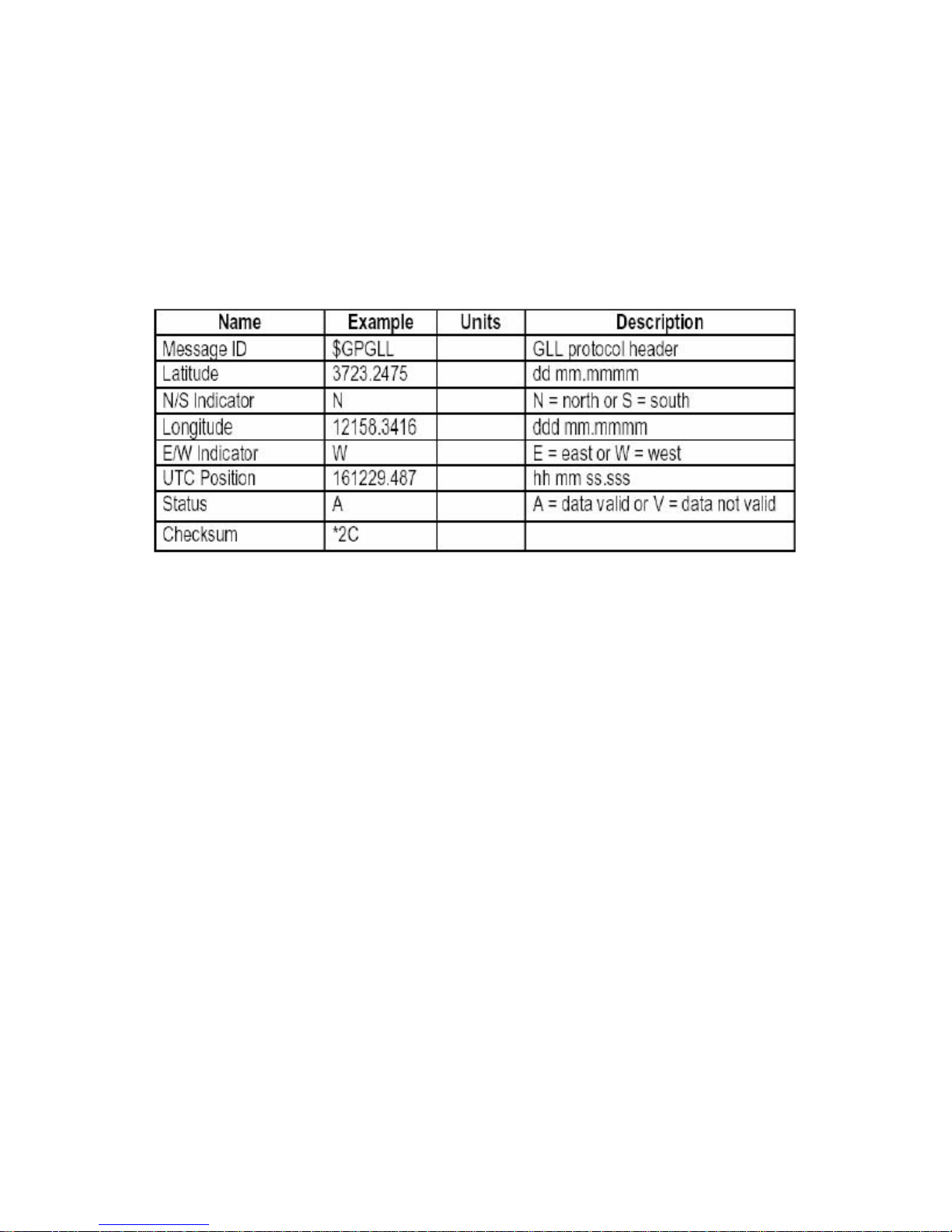
A.1.2 Geographic Position - Latitude/Longitude (GLL) Samples:
$GPGLL,3723.2475,N,12158.3416,W,161229.487,A*2C
Table 1-4 GLL Data Format
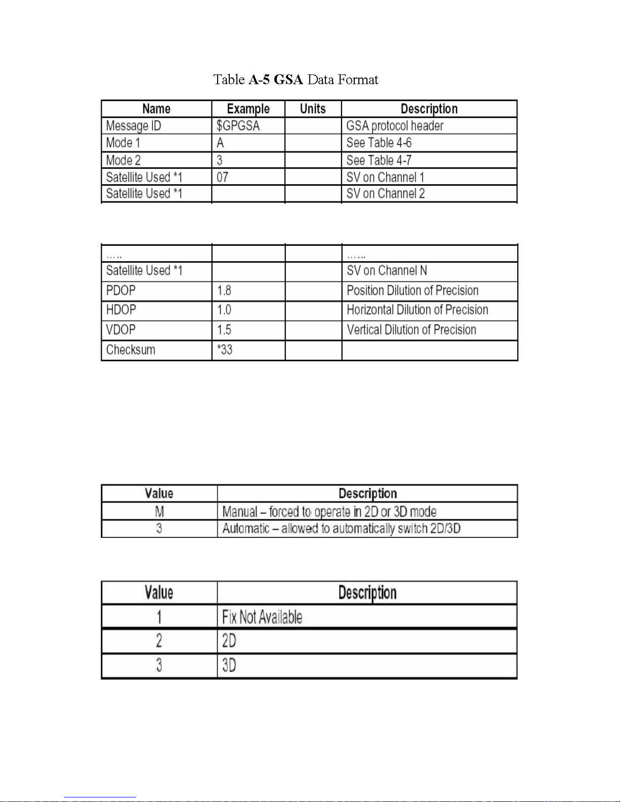
A.1.3 GNSS DOP and Active Satellites (GSA)Samples:
$GPGSA,A,3,07,02,26,27,09,04,15, , , , , ,1.8,1.0,1.5*33
ZENSTAR III USER’S GUIDE
12
*1 Satellite used in solution.
Table A-6 Mode 1
ZENSTAR III USER’S GUIDE

13
A.1.4 GNSS Satellites In View (GSV)
Samples:
$GPGSV,2,1,07,07,79,048,42,02,51,062,43,26,36,256,42,27,27,138,
42*71
$GPGSV,2,2,07,09,23,313,42,04,19,159,41,15,12,041,42*41
Table A-8 GSV Data Format
NOTE: Item <4>,<5>,<6> and <7> repeat for each satellite in view to a
maximum of four (4) satellite per sentence. Additional satellites in view
information must be sent in sentences. These fields will be null if unused.
ZENSTAR III USER’S GUIDE
14
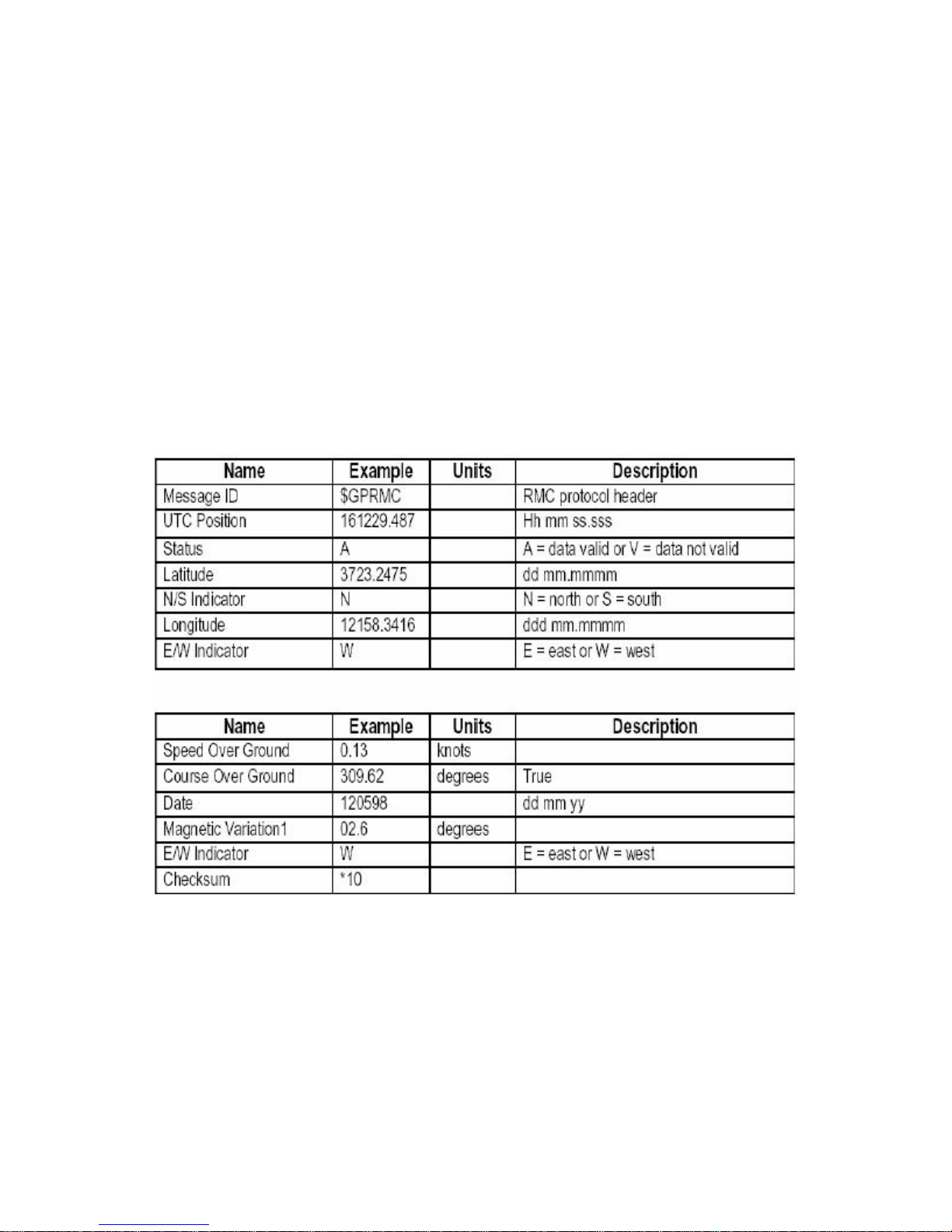
A.1.5 Recommended Minimum Specific GNSS Data (RMC)
Samples:
$GPRMC,161229.487,A,3723.2475,N,12158.3416,W,0.13,309.62,12059 8,
,*10
Table A-9 RMC Data Format
ZENSTAR III USER’S GUIDE
15
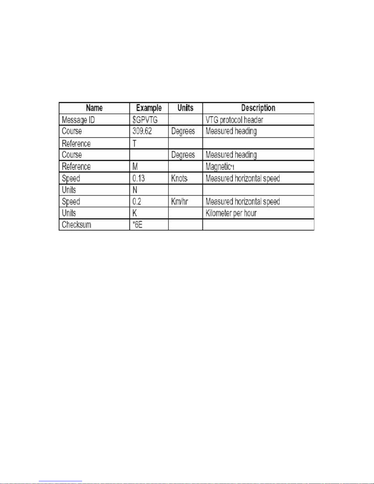
A.1.6 Course Over Ground and Ground Speed (VTG)Samples:
$GPVTG,309.62,T, ,M,0.13,N,0.2,K*6E
Note *1:All "course over ground" data are geodetic WGS84.
ZENSTAR III USER’S GUIDE

16
A.1.7 Time & Date (ZDA)
Samples:
$GPZDA,114523.62,12,04,2001,10,34*6E
Table 1-11 ZDA Data Format
ZENSTAR III USER’S GUIDE

17
Appendix B Coordinate System and
Output Settings
B.1 Coordinate System
The ZENSTAR has the world standard coordinate system WGS84 built in.
B.2 Output Settings
Coordinate System: WGS84。
Baud rate: 9600
Output message: GGA, GLL, GSA, GSV, RMC, VTG , ZDA
ZENSTAR III USER’S GUIDE
Table of contents


