GEONAUTE COMPASS C200 User manual

Réf notice : 409.618
CNPJ : 02.314.041/0001-88
Made in Taiwan
Hecho en Taiwan
Fabricado em Taiwan
Произведено во Тайване
NOTICE_C200 TLL 9/08/06 12:17 Page 1

Boussole
Compass
C200
NOTICE_C200 TLL 9/08/06 12:17 Page 2

EN
8
1. compass direction-of-travel arrow
2. magnetic needle
3. needle alignment mark (red line)
4. outer dial
5. scales in cm
6. scales in inches
7. 1/25000 scale
8. UTM scale
9. plate
1
2
3
4
5
6
8
7
9
NOTICE_C200 TLL 9/08/06 12:17 Page 8

You have just acquired a Geonaute C200 base plate
compass, and we thank you for your confidence in us.
This device enables you to orient yourself outdoors and
to calculate a position or an itinerary on a map. Its
ergonomic design offers maximum ease of use with a mini-
mum space requirement in your backpack. Its UTM scale
makes it easier to read the position given by a GPS on a topo-
graphical map featuring this scale system.
Use/Guidelines
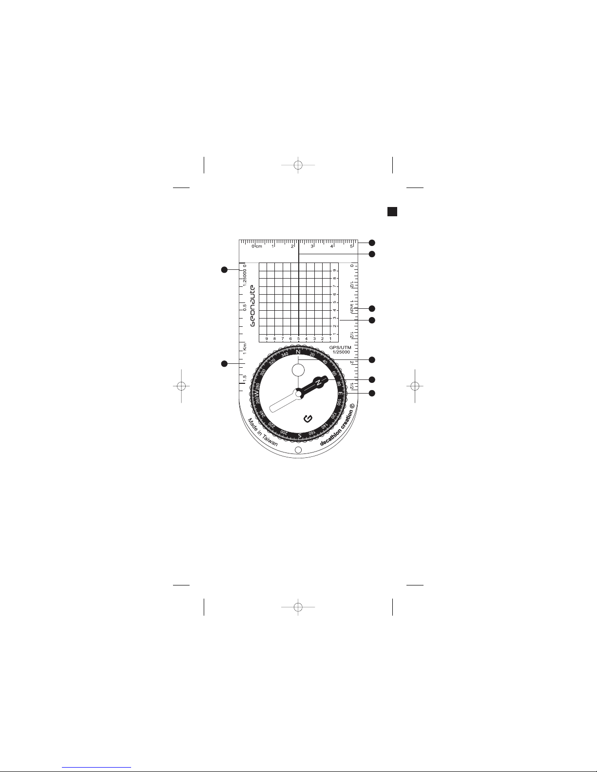
Description of normal conditions of use
The C200 compass is designed to determine an angular direction (also called
BEARING or AZIMUTH) in relation to magnetic north. It features several
scales that enable you to measure distances on maps.
Restrictions on use/precautions for use
1.Compasses must always be used HORIZONTALLY. It is very important to
avoid friction against the dial's pivot point by holding the instrument no more
than 5 degrees from a horizontal position.
2.This compass detects the Earth's magnetic field. It is very important to keep
this instrument away from any sources of electromagnetic disturbance (high
voltage, emission of waves, e.g. telephone, cell phone, radio, or television;
and objects containing ferrous metals).
3.The compass detects MAGNETIC north, which is not in exactly the same
place as Geographic north. The difference (declination) depends on the
position of the user on the globe and is given by the following table.
Declination values for a few major cities around the world. For your city, use
an average value between 2 nearby cities.
If the declination is west (W), subtract the indicated value from the value you
have just read. If the declination is east (E) add the variation to the value you
have just read.
The position of magnetic north also changes with time, but these variations are
negligible over a time span of a few years.
4.A compass is a precision instrument. Do not drop it.
5.The operation of the compass varies with the temperature. The oil that slows
the needle may congeal or liquefy depending on the ambient temperature. In
order to preserve its performance capabilities, protect the compass from
extreme temperatures (e.g. by keeping it under a garment).
6.The compass requires a few seconds to stabilize. Do not take the reading
into account until the needle has stabilized completely.
7.To use this compass, you need to have a map. Opt for a map with a scale
available on the compass. For optimal use, also bring along a wooden
pencil and an eraser.
City Declination
Bombay 1°W
Boston 16°W
Chicago 3°W
Denver 10°E
London 4°W
Munich 1°E
New York 14°W
Paris 2°W
Rio de Janeiro 21°W
San Francisco 15°E
Shanghai 5°W
9
EN
NOTICE_C200 TLL 9/08/06 12:17 Page 9

10
Using the compass
4 functions correspond to different orienteering needs:
A.I know where I am and I have located my destination on a map. How do I
take a bearing (the angular direction in relation to the north)?
B.I know where I am and I have taken the bearing (angular direction) to follow.
How do I find my way?
C. I don’t know where I am… how do I determine my position on the map?
D. How do you measure distances on the map?
Explanation of each operating mode
A. Determining an angular direction (Azimuth) on a map (I am at
position A and I must go to B - which azimuth should I
follow?).
1.Position yourself on a flat, level spot. Mark the departure point (A) and the
arrival point (B) on the map.
2.Turn the dial of the compass in such a way as to align the red line (3) with
the direction-of-travel arrow of the compass (1). Orient the compass by
aligning the needle of the compass and the North of the graduated scale of
the dial.
3.Place the compass on the map. Turn the map without changing the orientation
of the compass and orient the North of the map towards the North indicated
by the compass needle.
4.Keeping the map pointing North, turn the plate of the compass without changing
the position of the dial (red needle and red line aligned). Bring the direction-
of-travel arrow of the compass (1) to the direction (AB) to be measured.
5.Take the bearing (the angle formed by the direction to be measured and
magnetic north) on the graduated scale of the dial (i.e. 340°) at the position
marked by the white line in the direction-of-travel arrow.
6.Forward march! Now you know which direction to take…
B. How do you get to point B from point A, which you have
found on the map?
EN
NOTICE_C200 TLL 9/08/06 12:17 Page 10

1.In preparation: mark points A and B on the map. Draw a straight line between
the two (AB).
2.Place the compass on the map. Turn the map and orient the north of the map
towards the magnetic north indicated by the compass. (see point 2 and 3 of
mode A).
3.Without moving the map, turn the whole compass to align its direction-of-
travel arrow with the line (AB) to be measured.
4.Rotate the dial without moving the plate until the magnetic needle is lined up
with the red marking of the capsule and the 0 of the scale marks. Read the
bearing (AB) at the intersection of the scale and the direction-of-travel arrow
of the compass.
5.Without changing anything, now you simply head in the direction of the direc-
tion-of-travel arrow of the compass, keeping the compass flat and the needle
over the red marking of the capsule.
C. Determining your position outdoors using triangulation (I am
lost; how do I locate my position on the map?)
1.When you are lost, the first thing to do is to move to a promontory from which
you can observe in the landscape at least 2 landmarks (R1 and R2), that you
can also see on the map (mountains, lakes, bell towers). Ideally, the angle
of these two points in relation to your position should be 90° (they must never
be one behind the other or in opposite directions).
2.Point the direction-of-travel arrow towards landmark R1. Without changing
the orientation of the plate, turn the dial until the needle is over the red line
(3). Read bearing A at the intersection of the scale and the direction-of-tra-
vel arrow of the compass.
3.Place the map on a level surface and turn it so that the map's north is pointing
towards magnetic north indicated by the compass (see point 2 and 3 of mode A).
4.Find landmark R1 on the map. Orient the compass, starting at landmark R1
until the direction-of-travel arrow coincides with the bearing you measured
before. Use one of the long edges of the compass to draw the measured
bearing, passing through landmark R1.
5.Locate landmark R2, and then note the value of the bearing you have
measured (see mode B).
6.Turn the compass on the map (without moving the map) until the direction-
of-travel arrow of the compass is aligned with bearing B. Draw a straight line,
passing through R2.
7.Your position is thus at the intersection of the two bearings on the map.
8.We strongly recommend that you repeat the procedure a 3rd time with a third
landmark (R3) for greater safety. Now you know where you are.
11
NOTICE_C200 TLL 9/08/06 12:17 Page 11

EN
12
D. How do you measure distances on the map?
This compass features 3 scales enabling you to measure and calculate distances
on a map:
- 1 European scale in cm
- 1 scale in inches
- 1 European scale 1/25 000
The compass also features a UTM grid to use on maps with a UTM-WGS 84
projection.
Maps with a 1/25000 scale have a grid whose lines are spaced 1 km apart.
When reading the GPS position in the UTM system, position the O of the
compass grid on the corner corresponding to the coordinates given by the
GPS, then carry the decimal number of the position directly to the compass
scale.
Be careful about the direction in which the coordinates increase (especially in
the Southern Hemisphere).
Contact
As we strive to continually improve the products we develop, we are interested in
your feedback regarding the quality, the functionality and the usage of our
products.
- In France, please call the customer service center at : 0810 08 08 08 (local
call)
- For any other country, please leave a message under the relevant heading
on our website www.decathlon.com
We promise to answer you promptly.
NOTICE_C200 TLL 9/08/06 12:17 Page 12
Table of contents
Other GEONAUTE Compass manuals