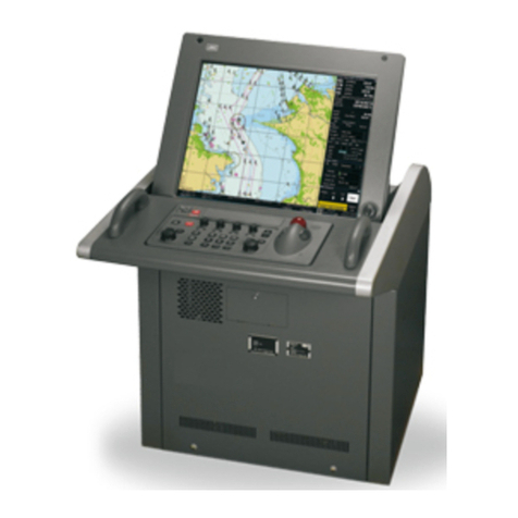
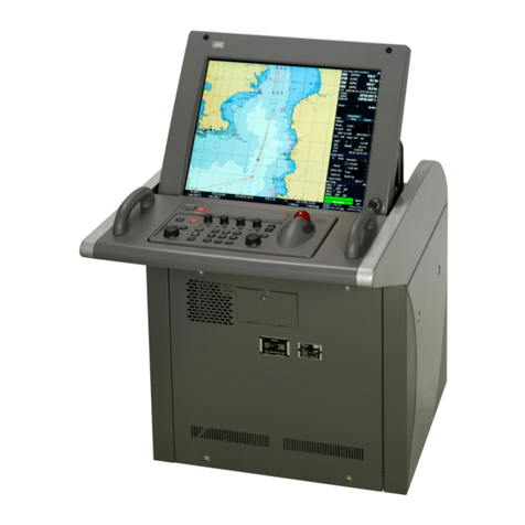
JRC JAN-2000 User manual

18.1 or 19−inch high visibility displays
Simultaneous display vector and raster charts
Multiple and wide screen viewing
Flexible black box configuration
Cost effective installation
– JRC’s new high performance ECDIS represents a signicant step change in terms of cost-eectiveness
Complies with new SOLAS regulations
MSC 232(82) performance standard for
ECDIS, eective from 1 January 2009.
JAN-2000
ECDIS

JAN-2000 ECDIS – fully type approved and ec
JAN-2000
– performance features
The new JAN-2000 is a high-performance and fully type
approved ECDIS system with excellent on-screen menus,
which will greatly shorten most users’learning period.
The new JAN-2000 ECDIS system is fully type approved,
and because of its controlled interface it is also highly
cost-eective. It only has gyro, log, GPS 1 & 2 and AIS as
standard. TCS and radar overlay is not possible.
This makes the JAN-2000 an economical and well-tted
ECDIS solution yet still integrates the high performance
standard you would expect from JRC.
Cost-effective solution
Unique features
Also, it is easy to active, deactivate
and switch between AIS target
symbols. This simply can be done
with an integrated AIS lter,
prioritising the targets within a
dedicated area.
Multiple and wide screen viewing is possible with the new
JAN-2000. You can divide the chart screen into two sections,
in which the same or dierent charts can be displayed, in a
mixture of ways. In this eld of view, it provides a‘look-ahead’
capability, especially useful in coastal areas. With the wide
screen view function, an additional screen in the display area,
showing a segment of the chart, allows viewing at a glance.
Multi-view
The AIS is an important key device used to indicate AIS target symbol and information
on the ECDIS. These targets are very useful, as it provides the maneuvering conditions
of other ships at a glance, allowing for safe and eective navigation. The name of
AIS targets
the vessels, and bearing, range, speed,
length, heading and much more AIS target
specics from other ships are received and
displayed. The AIS symbols are continuously
displayed on-screen without the inuence
of the radar characteristics. The AIS targets
are never shielded by ground, rain or cloud
reections, nor are they eliminated by
adjustments of anti-sea or anti-rain clutter.
120nm
1
24
3
1. vessels’ position
2. ring area
3. sector area
4. heading area
Standard
Gyro
Log
GPS 1+2
AIS

Menu title bar
Display panel
Chart display area
North arrow mark
Route information bar
As standard, the JAN-2000 integrates a grounding avoidance function, which protects vessels from collision
and entering dangerous areas. This system allows real-time display of the ship’s position on electronic charts,
allowing to easily avoid routes for dangerous areas. You can simply make a crossing warning and it is possible
to check safety contour lines and dangerous at the route planning stage.
Grounding avoidance
onomically configured
JAN-2000
– developed for maximum ease of use
Honolulu
San Diego
Los Angeles
Houston
Chicago
Toronto
New York
Miami
St. John’s
Havana
Panama
Lima
Guayaquil
Talchuano
Buenos Aires
Reykjavik Torshavn
Belfast
London
Le Havre
Lisbon
Las Palmas
Dakar
Abidjan
Cape Town Durban
Richards Bay
Madrid
Rome
Tunis Athens
Istanbul
Limassol
Alexandria
Haifa
Dubai
Mumbai
Columbo
Vladivostok
Tokyo
Pusan
Shanghai
Taipei
Manila
Hanoi
Hong Kong
Bangkok
Kuala Lumpur
Singapore
Jakarta
Suva
Brisbane
Sydney
Melbourne Auckland
Egersund Lund Tallinn
Helsinki
Amsterdam
Rotterdam
Antwerp
Rio de Janeiro
San Francisco
Seattle
Vancouver
JRC has been providing sales and support of products since 1915. Today, JRC oers comprehensive assistance
through its organisation, in partnership with a worldwide StarNetwork™ of over 270 fully trained and qualied
partners and agents, assisting you 24 hours a day, 7 days a week and 365 days a year.
JRC StarNetwork™
JRC one-call™
One number to call
With JRC you can go anywhere and
if you need our support, simply call us
at +81 3 3492 9201, anytime.
The JAN-2000 18.1-inch and 19-inch
colour display is able to show bright,
high-resolution imagery. With a press
of a button, the screens’brightness
can automatically be adjusted to the
most optimal condition.
You can also select from multiple
background modes, a practical
feature which facilitates a clear sight,
this in view of the ever changing
lightening conditions on the bridge.
Optimised viewing
The JAN-2000 ECDIS can directly be connected via LAN to JRC’s VDR and S-VDR. This way, you can
easily backup important data, without the need for additional interfaces.
Backed up via LAN

JAN-2000
– system exibility
Flexible black box configuration
The processor unit is the heart of the JAN-2000, and shares the same simple conguration as the
current JAN-701B/JAN-901B ECDIS series, contributing to an enhanced system conguration. It is
also possible to install our type approved 19-inch LCD display as alternative.
What’s standard in the box?
1. Display1
2. Keyboard
3. Processor
4. Cables
5. Spare parts
7. eToken for C-Map Ed.3
8. Manual (English)
Which cables? Std.
Display to processor 2 m
Keyboard to processor 2 m
Interfaces
On the back of the processor you will nd four USB ports, a DVD
drive. Simply connect a printer, USB storage device for saving and
reading les, or you can plug in a C-Map dongle for your charts.
Man OverBoard
Some items could strike you on the vessel, a slippery deck
or unexpected movement of the vessel are situations in
which a person may possibly fall of the vessel. The JAN-2000
integrates a single-press Man OverBoard (MOB) operation.
Instantly, a dedicated symbol arises on the screen, providing
a range detailed info such as positioning, bearing, range and
time till arriving at MOB. This emergency system enables
immediate and accurate search and rescue eorts.
Advanced route planning
The advanced nature of JRC’s new JAN-2000 ECDIS system
allows route planning in dierent ways. Either plan your route
by using the table editor, while displaying current waypoint
or graphically draw your next waypoint on the chart. Editing
the route is just as simple as inserting. Dedicated menus
are readily available to assist the mariner in eective route
planning. Not only can you save the routes, but import
favourite or commonly used les, even from previously ECDIS
models, using industry-standard CSV format.
During the voyage, you can add an alternative route, which
can be displayed simultaneously. You can move, insert,
add and delete waypoints instantly and easily exchange
the alternative route with route in progress, at your own
convenience.
Route planning with
table editor while
displaying waypoints
1 18.1-inch standard (including bracket)

JAN-2000
– dimensions and mass
Dimension drawings - Display
NWZ-147-AC MASS 14,5 kg
450 mm
425 mm
391 mm
18.1”
Dimension drawings - Display
NWZ-173-E MASS 12,1 kg
450 mm
425 mm
391 mm
19”
Dimension drawings - Keyboard
NCE-7721C MASS 3,5 kg
400 mm
210 mm
52 mm
Dimension drawings - Processor
NDC-2000 MASS 10,5 kg
300 mm
337 mm
341 mm
170 mm
cutout for panel mount height 319,6 mm, width 416 mm, depth 80 mm
cutout for panel mount height 94 mm, width 384 mm, depth 34 mm

JAN-2000
– specications
All specications are subject to change without notication.
Model JAN-2000
IMO compliant
General
Power supply 100V to 115V, 200V to 230V AC ±10%, 60/50Hz ±5%
Power consumption 160VA max. (120VA typ.)
Display
Size 18.1 inch or 19 inch colour LCD display
Resolution 1280 by 1024 pixels (SXGA)
Bearing indication north-up / course-up (simultaneously in multi view)
Presentation mode true / relative / free motion
Multi display areas 2 (longitudinal, transverse, picture in picture)
Scale 1:1.000 up to 1:75.000.000
Range 0.125 - 120 NM
Vector charts ENC S-57 Ed3.0/3.1, S-63 (ENC, AVCS security scheme) C-Map Ed.3
Raster charts ARCS Navigator service / Skipper service
Route planning
Input graphical or numerical
Safety check grounding, obstruction, dangerous areas
Import/export format CSV
Monitoring
Plotting Own vessel position and track
TT (ARPA) targets 200
AIS tracking 300 (activated 100 + sleeping 200)
AIS class class A + class B
AIS/ARPA alarm CPA/TCPA
Chart management
Updating semi-auto / manual (available via ChartCo)
Data correction available
Functions
Route planning route editing, alternative route editing, safetly check of planned route
Navigation monitoring own ship’s position, crossing safety contour, approaching obstruction and prohibited areas,
cross track error, arrival at waypoint, o course, dragging anchor
Operation multi-view, scrolling, data recording (up to 90 days), printing of screen/route/logbook
Interfaces
IEC61162-1 RX 4ch, TX 3ch
LAN built-in 10/100 Mbps
Copying route USB
Optional items
Display 19-inch LCD NWZ-173-E
NSK unit NCT-4106A
Serial add-in board NQD-2888
PC mini keyboard PCP-ACK-595 US-PS2-R
PC trackball ST-45UPI
Manual chart installation (English) 7ZPNA4111
2009.8 2009.8 CAT.No.Y14-211 (No.813-1-3)D Printed in Japan
v
Table of contents
Other JRC Car Navigation System manuals