VMS Touring 500 User manual

TM
QUICK START GUIDE
Touring 500

TM
Product Introduction
The VMS Touring 500 navigates just as well in the outback as it does around town!
Ideal for touring the outback, the Touring Series features the iTOPO* topographic mapping system
and is complete with 4WD tracks, camp sites, caravan parks & other vital info so you can explore
the most remote regions in complete confidence.
Street navigation uses the latest Where IS mapping for Australia. Featuring spoken street names
and easy to follow voice guidance the VMS Touring will get you safely and quickly to your
destination.
With the VMS reverse camera package, the Touring 500 can also display up to 2 camera images
automatically.
Designed in Australia, we believe that the Touring Series is the best GPS for touring & 4WDs!
*iTOPO maps are optional

TM
Quick Start Guide
1. Whats in the Box..........................................
2. Touring 500 Illustration................................
3. Getting Started
3.1 Inserting SD memory Card.......................
3.2 Installing the Touring 430..........................
3.3 Power ON/OFF & Sleep modes................
4. System Menus
4.1 System main menu...................................
4.2 System settings menu...............................
4.3 System volume settings............................
4.4 System battery settings.............................
4.5 System backlight settings..........................
4.6 System date & time settings......................
4.6.1 System time settings...........................
4.6.2 System date settings...........................
4.6.3 System time zone settings..................
4.7 System language settings.........................
4.8 System information....................................
5. System Extras Menus
5.1 Multimedia extras menu............................
5.1.1 Photo browser menu...........................
5.1.2 Photo viewer........................................
5.2 Video browser menu.................................
5.2.1 Video viewer........................................
5.3.1 Music browser.....................................
5.3.2 Music player........................................
6. Street Navigation
6.1 Getting started with street navigation........
6.2 Navigating to an Address..........................
6.3 Using the on screen keyboard...................
6.4 Map View...................................................
6.7 Street nav settings...........................
7. Topographic GPS (Off road navigation)
7.1 Toolbar.............................................
7.2 Toolbar buttons................................
7.3 Browsing around the map................
7.3.1 Selecting a map.........................
7.4 Planning a Route..........................
7.5.1 Navigation along a route............
7.5.2 Navigation window.....................
7.6 managing overlays...........................
7.7 Find place........................................
7.8 Finding a place by coordinates........
7.9 System coordinate format................
7.10 Installing PC software....................
8. Reverse Camera
8.1 Installation........................................
8.2 Operation.........................................
9. Safety and product information........
10. Product warranty..............................
11. Caring for your Touring 500.............
12. Technical Support.............................
13. Specifications...................................
CONTENTS
.4
.4
.5
.5
.5
.6
.6
.7
.7
.7
.8
.8
.8
.8
.9
.9
.10
.10
.10
.11
.11
.11
.12
.12
.13
.15
.16
.18
.19
.20
.21
.21
.22
.23
.23
.24
.24
.25
.25
.26
.27
.27
.27
.28
.29
.30
.31
.31
TM
Quick Start Guide
1. What’s in the box
- 1 x VMS Touring Series 5.0” GPS - 1 x 12-24V DC cigar charger
- 1 x Windscreen suction cup mount - 1 x USB Cable
- 1 x Mounting bracket - 1 x DVD disk
- 1 x Stylus - 1 x Quick Start Guide
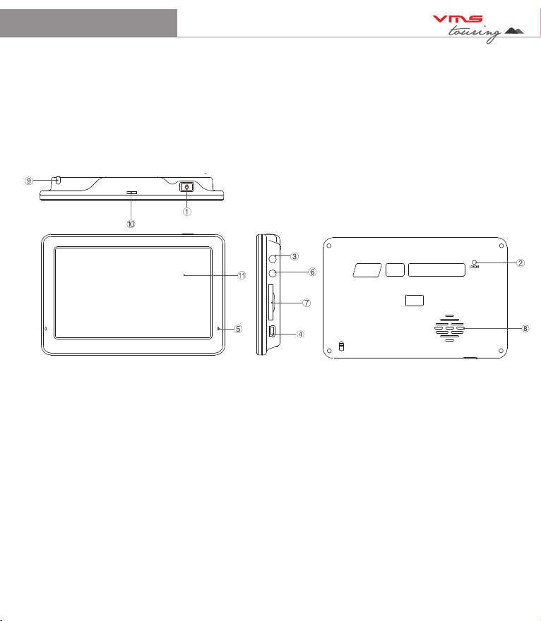
2. Touting 500 Illustration
1. Power button.......................Press for 1 sec to enter sleep mode. Press for 5 secs for power off.
Press for 1 sec to turn on.
2. System Reset......................Resets the entire system when system is non-responsive.
3. Camera input.......................Input for Reverse Camera cable.
4. USB charger........................Car charger input, USB type.
5. LED indicator.......................Red when charging / green when fully charged.
6. Earphone jack (3.5mm)...... Audio output 3.5 mm earphone.
7. SD card slot........................ Suitable for 1 SD or SDHC memory card (up to 8GBs Class2).
8. Speaker............................... Audio output.
9. Stylus Pen...........................Stylus pen for improved touchscreen accuracy.
10. Mounting Bracket Holder...Location pins for mounting bracket.
11. LCD display....................... 5.0 inch Display with touchscreen.
4
TM
Quick Start Guide 5
3.2 Installing the Touring 500.
Step 1: Select a suitable location to mount the GPS on your windscreen.
Step 2: Clean & dry the suction cup and select the area of your windscreen.
Step 3: Plug the Car Charger into the side of the GPS.
Step 4: Attached the cradle to the suction cup mount.
Step 5: Adjust the angle with the rotary clamp if necessary.
Step 6: Place the suction cup on the windscreen and secure with rotary latch.
Step 7: Place the bottom of the GPS on to the cradle and gently snap the top of the GPS into the
cradle.
Step 8: Plug the car charger into a power outlet in your vehicle. Your unit should turn on
automatically if it is plugged in and your vehicle key is turned to ON/ACC.
3.3 Power on/off & sleep mode
Power on: press the power button for 2 secs.
Power off: press the power button until the unit displays “POWER OFF MODE”. This mode
powers down the system completely allowing long periods of storage without
discharging the battery.
Sleep mode: press the power button for 2 secs & the unit display “ENTERING SLEEP MODE”.
This modes puts the system into sleep and allows for fast start up. During sleep
mode the system is not completely off and the battery will be discharged in a few
days.
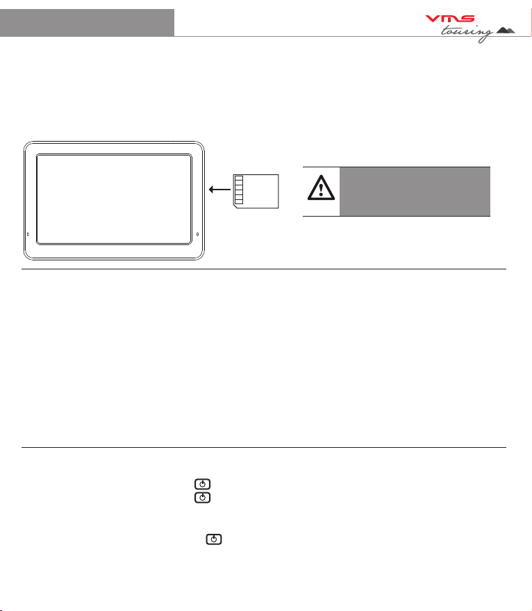
3.1 Inserting SD Memory Card
Step 1: Remove sd card from its plastic holder.
Step 2: Locate the SD card slot on the right side of the Touring 500.
Step 3: Ensure orientation of the SD card is correct.
Step 4: Insert the SD card by sliding it gently into the slot completely. The card will click
indicating correct installation.
Caution
Please note the orientation of
the sd card before inserting
TM
Quick Start Guide 6
Tip
When not using the Touring GPS for an extended period (few days or longer)
power off the unit completely.
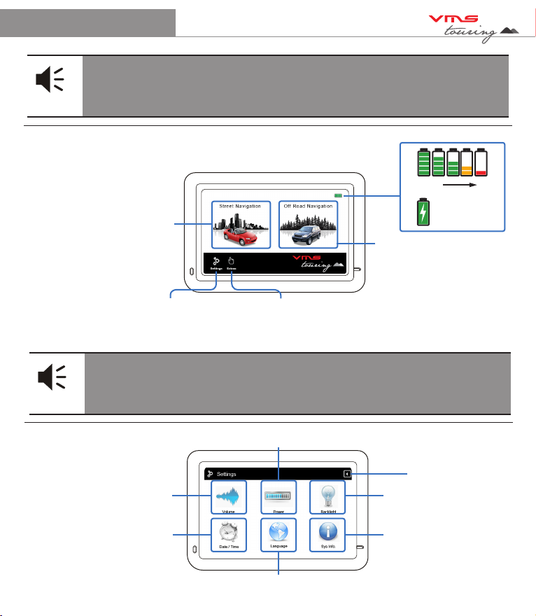
4.1 Using the System Main Menu
Street Navigation
Topographical GPS
System Settings Multi Media Extras
Battery Status
Select your mode of travel. For paved road travel, select street navigation.
For Off road travel, select topographical navigation.
Tip
Topographical Navigation is used where street navigation lacks accurate
information. Best used when on unpaved tracks & outback touring.
4.2 Using the System Settings Menu
100% 0%
Charging
Volume Settings
Date & Time settings
Main Menu Language Settings
Back to Main Menu
System Information /
Touchscreen Calibration
Display Backlight
Settings
Battery Management Settings
TM
Quick Start Guide 7
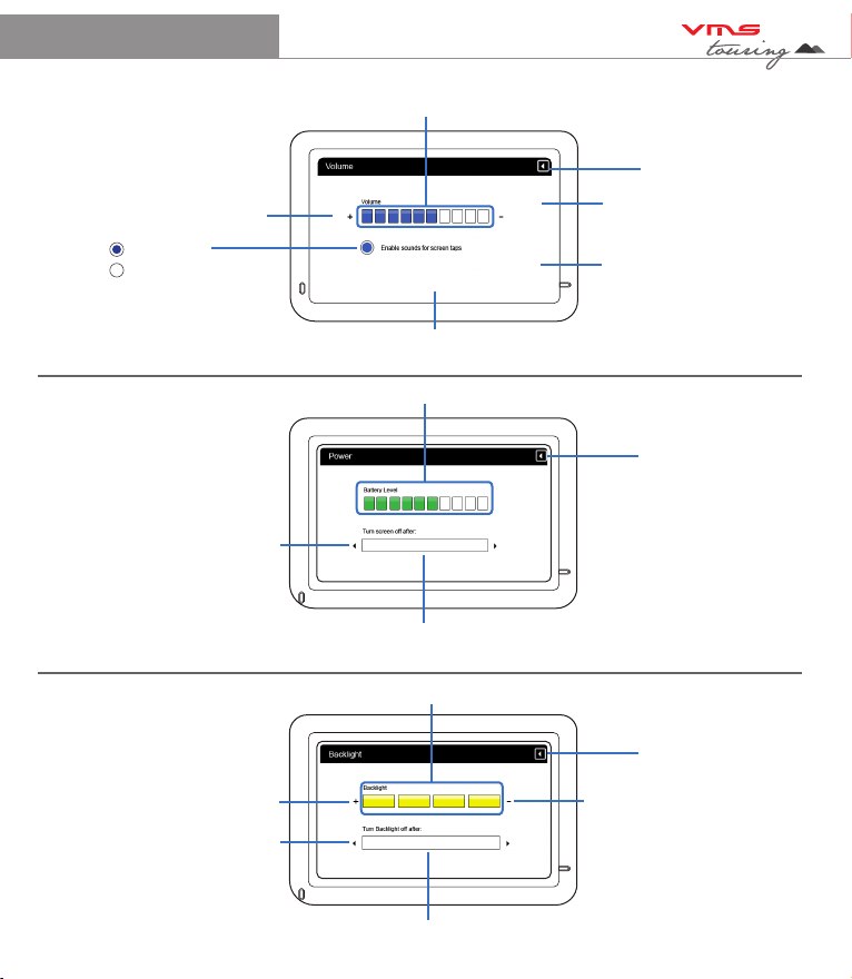
4.3 System Volume Settings
Tap to increase vol
Main Menu Language Settings
Back to Settings Menu
System Information /
Touchscreen Calibration
Display Backlight
Settings
System Volume Indication Bar
Enabled
Disabled
4.4 Battery Management Settings
Toggle auto sleep mode
Automatically Enter Sleep Mode
Always On / 1, 2, 3, 10, 30 mins
Battery level indicator
Back to Settings Menu
4.5 Display Backlight Settings
Toggle auto backlight
Automatically Adjust Backlight in
Always On / 1, 2, 3, 5 mins
Backlight Level Indicator
Back to Settings Menu
Increase backlight Decrease backlight

TM
Quick Start Guide 8
4.6 System Date & Time Settings Main Menu
Back to Settings Menu
System Time zone /
Touch to enter time zone
settings
System Time / Touch to
enter time settings
4.6.1 System Time Settings
+ or - hour toggle
Min Display
Hour Display
Back to Date & Time
Main Menu
4.6.2 System Date Settings
+ or - month toggle
Day indicator
Year Indicator
+ or - year toggle
System Date / Touch to
enter date settings
+ or - min toggle
+ or - day toggle
Month Indicator
Back to Date & Time
Main Menu
TM
Quick Start Guide 9
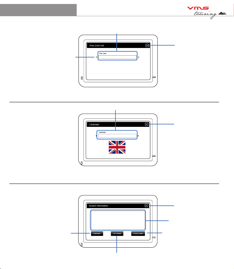
4.6.3 System Time Zone Settings
Back to Date & Time
Settings menu
4.7 System Language Settings Language indicator
Back to Settings Menu
4.8 System Information Settings
Reset GPS receiver
To calibrate the
touchscreen,
tap this button &
follow the on screen
instructions.
System Information Display
Back to Settings menu
+ or - time zone toggle
Time zone Indicator
System Language options is ENGLISH only.
Reset to factory settings

TM
Quick Start Guide 10
5.1 Multimedia Extras Menu
Back to Main Menu
5.1.1 Photo browser menu Files
Back to Settings Menu
5.1.2 Photo Viewer
Photo Display Area
Zoom in or out of photo
Back to Settings menu
Photo browser
Video browser
Back to Photo Browser Menu
Music browser
Scroll up or down
Browse
up one folder
Next or Prev photo
Full screen mode /
rotate photo

TM
Quick Start Guide 11
5.2 Video browser menu
5.2.1 Video Viewer
Back to Settings Menu
5.3.1 Music Browser
SD card content
Back to Settings menu
Back to Main Menu
Video Display
Vol indicator
Scroll up or down
Back to Settings Menu
Scroll up or down
Browse
up one folder
SD card content
Stop / Play / FF
Back to Video browser menu
Status indicator
Double tap le
to play
TM
Quick Start Guide 12
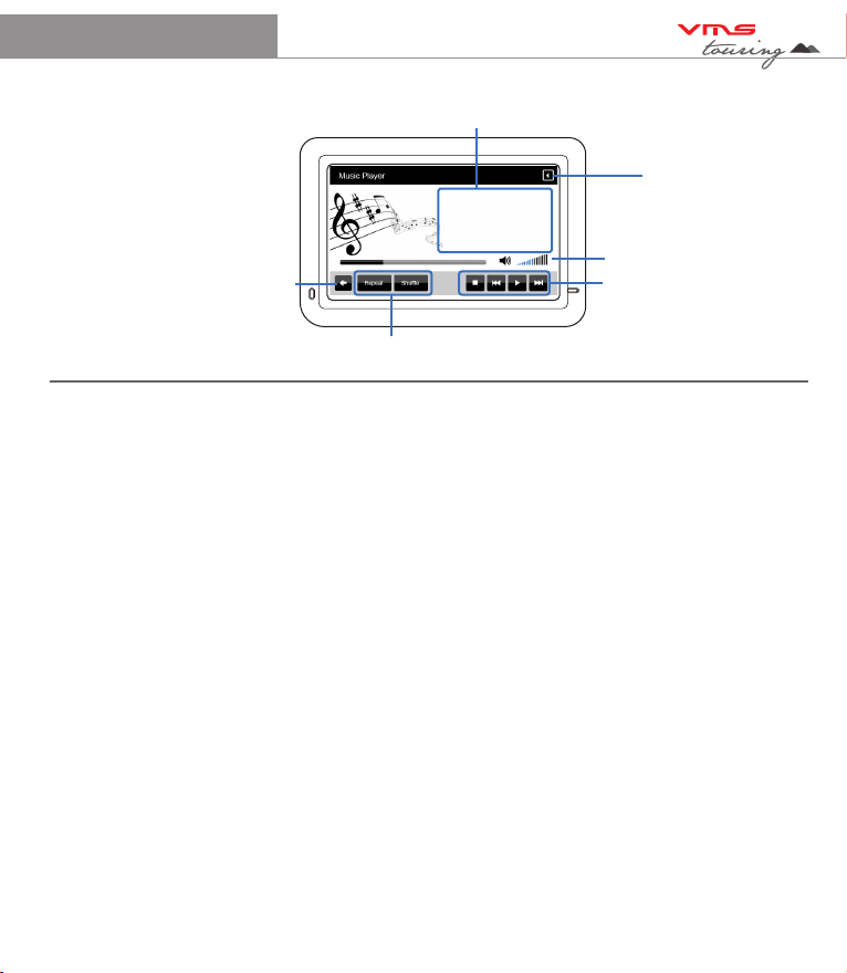
5.3.2 Music player
Back to Media Menu
Controls
Vol indicator
Track information
Repeat / Shue
Back to
Music Browser
6. Street Navigation
To Start Street navigation, select “Street Navigation” in the main menu.
This quick start guide will only cover basic functions. For a complete user manual, please visit
http://www.vms4x4.com/support.html
6.1 Getting started with Street Navigation
VMS Street Navigation is optimised for in-car use. You can use it easily by tapping the screen
buttons and the map with your fingertips. You do not need to tap the screen twice for any
function. With buttons and controls, a single tap is sufficient. VMS Navigation can plan routes
throughout the entire installed map set.
When Street Navigation is started the first time, you need to do the following:
1. Select the written language of the application.
2. Select the language and voice used for voice guidance messages. Please note, for Spoken
Street Names, Select a voice with text to speech (TTS).
3. The Navigation menu appears and you can start using Street Navigation.
The typical way of using Street Navigation is to enter a destination, and start navigating. You can
enter your destination a number of ways
• Enter a full address or a part of an address, for example a street name without a house number
or the names of two intersecting streets. Other methods are available. Please refer to the
complete user manual online:
http://www.vms4x4.com/support.html

TM
Quick Start Guide 13
6.2 Navigating to an Address
STEP 1: Navigation Menu (simple mode)
Touch
Find Address
Country
Suburb Prev entered
suburbs
Go to city centre
(if street not required)
Find Address Menu:
Street Name
Street No
State
Back to
Prev menu
Step 2: Enter Destination
Go to Street Midpoint if no
house number is required
Go to an intersection by
entering another street name

TM
Quick Start Guide 14
1. Tap the following buttons: (Simple mode).
2. By default, Street Navigation displays the country, state and suburb of where you are. If
needed, tap the button with the name of the country, and select a different one from the list. If
you select a new country, you also need to select the state, or tap to search for a suburb
regardless of the state it is in. If you have not changed the country, you can still change the
state. Tap the button with the name of the state and select from the list.
3. If needed, change the Suburb:
• To select a recently used suburb, tap the button.
• Or to enter a new suburb:
4. Start entering the suburb name using the on screen keyboard.
• After entering a couple of characters, a list of possible results will appear.
• Or, tap to open the list of results before it appears automatically.
5. Select the desired suburb from the list. To navigate to this suburb without a street entered,
press “City Centre”
6. To enter a street, tap
7. Start entering the street name using the on screen keyboard.
• After entering a couple of characters, a list of possible results will appear.
• OR, tap to open the list of results before it appears automatically.
8. Select the desired street from the list. To navigate to this street without a House number,
press “Street Midpoint”.
9. Enter the house number:
10. To enter a house number, tap
14. Enter the house number using the on screen keyboard.
15. Tap to finish.
16. The map appears with the selected point in the middle. Tap to start navigating to
this location. (Simple mode)
TM
Quick Start Guide 15
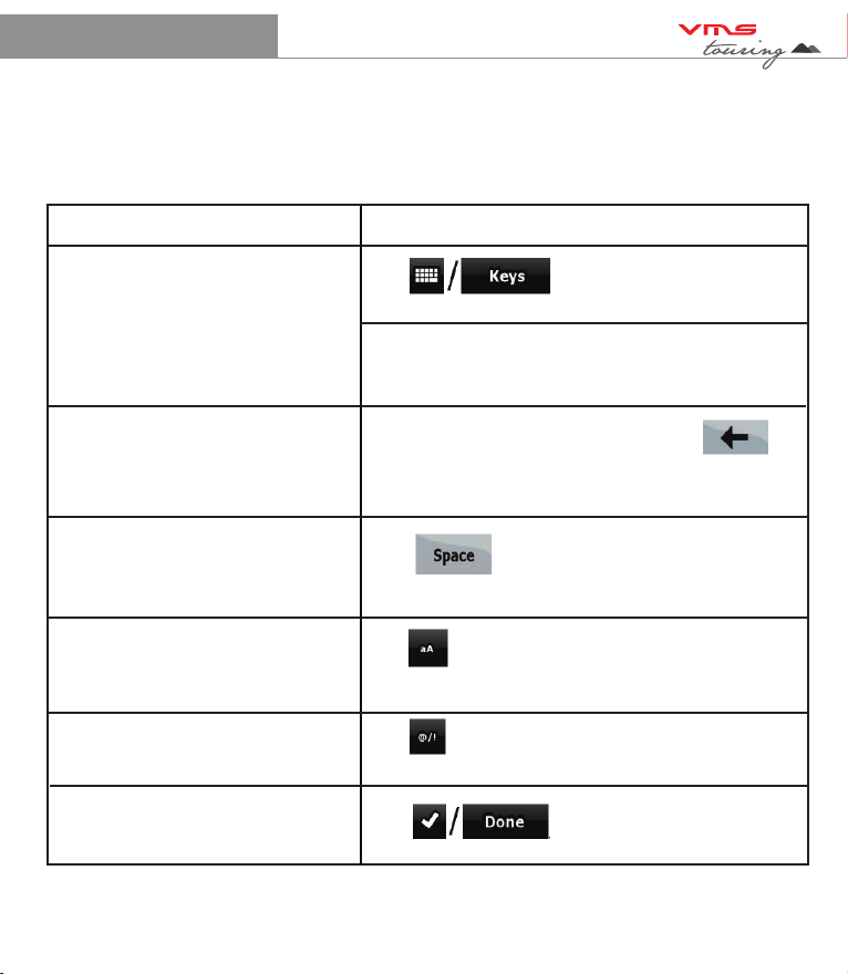
6.3 Using the On screen Keyboard
Type Description
Switching to another keyboard
layout, for example from a Latin
QWERTY keyboard to a Greek
keyboard
Tap , and select from the list of
available keyboard types.
VMS Navigation remembers your last keyboard
choice and offers it the next time you need to enter
data.
Correcting your entry on the keyboard Remove the unneeded character(s): tap .
Tap and hold the button to delete the entire input
string.
Entering a space, for example
between a first name and a family
name or in multi-word street names
Tap .
Entering small or capital letters Tap to cycle through entering lower case
letters, capital initials or all capitals.
Entering symbols Tap to switch to a keyboard of symbol
characters.
Finalising the keyboard entry Tap
You can enter letters or numbers in Street Navigation with your fingertips on the full-screen
keyboards and you can switch between various keyboard layouts, for example ABC, QWERTY, or
numerical.
TM
Quick Start Guide 16
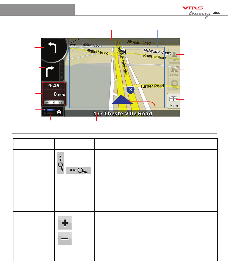
6.4 Map View
Toggle 3D / 2D
map view
Detour menu
Go to Cursor
Navigation Menu
Next turn
indicator
GPS signal
strength
Current road name
Next turn road name
Turn after next
turn indicator
500 m
Stats /
Dashboard
Battery
Status
Your position
Action Button (s) Description
Zooming in
and out
Activate
map controls
Tap this button to show or hide the following map
control buttons:
- Zoom in/out
- Rotate left / right (3D view only)
- Tilt up/down (3D view only)
- Zoom preset buttons (2D view only)
- Tilt and zoom preset buttons (3D view only)
- Return to GPS position button
- Smart Zoom Button
Changes how much of the map is displayed on the
screen. Street Nav uses high-quality vector maps that
let you see the map at various zoom levels, always
with optimised content. It always displays street names
and other text with the same font size, never upside-
down, and you only see the streets and objects that
you need. Map scaling has different limits in 2D and in
3D map view modes.
Map
TM
Quick Start Guide 17
Tilting up
and down
Rotating left
and right
Viewing
modes
Smart Zoom
Returning to
normal
navigation
(back to the
GPS
position with
automatic
map
rotation)
Changes the vertical view angle of the map in 3D mode.
Changes the horizontal view angle of the map in 3D
mode. When GPS position is available, Street Nav always
rotates the map so its top faces your direction of travel
(Track-up orientation). You can turn away from track up
with these buttons if GPS position is available and you
have rotated the map, the button appears. Tap this
button to re-enable the automatic map rotation.
Gives you the following map perspectives in Street Nav:
• Classic top-down view (2D)
• Perspective view (3D)
The value always shows the mode the button
switches to If you are in 2D mode, you can see the
button and you need to tap it to switch to
3D mode.
Street Navigation can automatically rotate, scale and
tilt the map and give you the optimal view:
• When you are approaching a turn, street navigation
zooms in and raises the view angle to let you easily
recognise your manoeuvre at the next junction.
• If the next turn is at a distance, Street Nav zooms
out and lowers the view angle to show you the road
in front of you. Tap this button once to enable Smart
Zoom.
Tap this button to move the map back to the current
GPS position. If the map has been rotated in 3D
mode, automatic map rotation is also re-enabled.

TM
Quick Start Guide 18
Tilt and
zoom preset
buttons
(available in
Advanced
mode only)
Tap one of the preset buttons to set the tilt and zoom
levels to fix, predefined values. Smart Zoom is
disabled. These buttons are available in 3D mode.
Tap & hold any of the buttons to set its value to the
current tilt and zoom levels, or to reset it to its original
value.
6.7 Settings
Map Screen:
3D settings
Colour Profiles
Elevation on 2D map
Street names during navigation
Land information
Sound:
Master Volume (Street Nav)
Voice Guidance Volume
Key Sounds
Dynamic Volume
Route Settings:
Vehicle Type
Road types used for route planning
Route calculation method
Regional Settings:
Program language
Voice profile
Units (km/mile etc)
Set Date & Time Format
Time and Time zone settings
Navigation Settings:
Keep position on road
Off route Recalculation
Restore lock to position
Automatic Overview
Warnings:
Warn when speeding
Warn if too fast for a pedestrian
Safety mode
Speed Camera warning
Settings page 2:
GPS Settings:
GPS Enabled
Port & Baud rate
TMC Settings: (Not applicable in Touring
Series)
Menu Settings:
Animation
Background
Device Settings:
Power Management
Tracklogs Settings (Not applicable in Street
Nav)
About Street Navigation
Maps
Credits
Safety
Legal
A DETAILED STREET NAVIGATION USER
MANUAL VISIT:
www.vms4x4.com/support.html
CLICK ON PRODUCT MANUALS
TM
Quick Start Guide 19
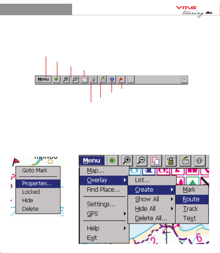
7. Topographic GPS (optional)
7.2 Tap-and-hold menu 7.3 Menu system
7.1 Toolbar
The Toolbar provides access to most of the functions in VMS topo. Another less obvious control is
the TAP-AND-HOLD technique. Tap-and-Hold is equivalent to a right mouse click on a PC. Simply
Tap on an object like a map, mark or position symbol, hold for a moment without moving, then
release. A menu will appear that is related to the where you tapped.
Advanced features and settings.
Full Screen toggle on/off
Zoom / Scale map in & out
Alt view toggle between two views
Mark Place (Waypoint)
GPS Status
Data Box on/off
Lock onto GPS
TM
Quick Start Guide 20
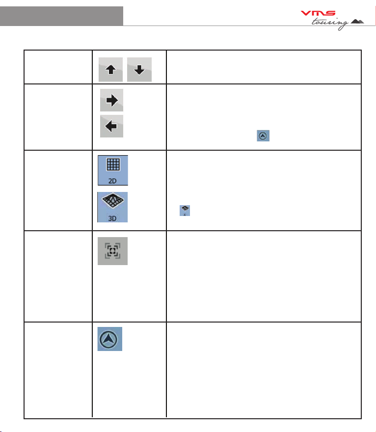
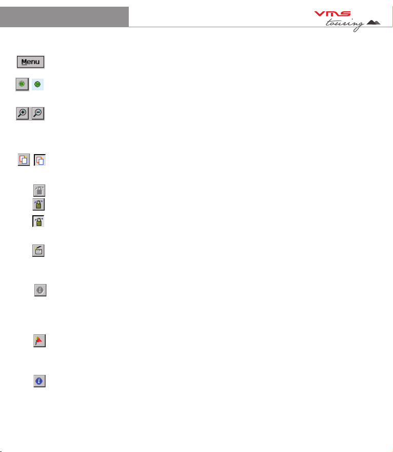
7.2 Toolbar buttons
Menu - Access to more advanced features and settings
* - Toggle Full Screen on/off. Whilst in Full Screen mode, large transparent touch buttons
remain on the right hand side of the screen for Zooming in and out.
ZOOM - Zoom in or out with automatic map scaling. When you have reached the
maximum or minimum zoom level for a particular map the next tap will take you to the next
available map scale. Tap-and-hold on the map to manually choose from the list of maps
available at that location.
ALTERNATE VIEW - Toggles between two views (Zoom / Scale levels of choice) of the
same map.
GPS LOCK - When you have a GPS fix the "Padlock" button will appear. Tap the Lock
button to automatically display your current position. Your position is shown as a flashing
red cursor with an arrow indicating your direction and speed of travel. The map will
automatically scroll as you move. To scroll around the map, you will need to toggle off the
lock button. Toggling it back on brings the map view back to your position.
DATA BOX - Select the data box and tap on the map to see grid coordinates and
route/track information. Use the Menu > Overlay > Settings... command to set your
preferred units of measurement, magnetic variation and the size of the velocity vector.
INFORMATION - The blue Information button will appear whilst your GPS position is being
calculated. Tapping the Blue information button will simply bring up a dialogue box that
states you have No GPS Signal. Once a signal is acquired the Blue information button will
become greyed out and unavailable. For detailed status tap Menu > GPS > Satellites.
Mark / Waypoint - To plot a waypoint. Tap this button & tap anywhere on the map. A flag will
appear to show that a waypoint has been placed. To plot another waypoint, repeat the
above procedure
To create a waypoint at the current position, select “MENU” > “GPS” > “MARK POSITION”.
A waypoint marker will be placed at the current location.
Table of contents
Other VMS Car Navigation System manuals


Popular Car Navigation System manuals by other brands


Garmin
Garmin GVN 53 - Navigation System owner's manual

Kenwood
Kenwood DNX installation manual

Motorola
Motorola TN20 - MOTONAV - Automotive GPS Receiver installation instructions

Rand McNally
Rand McNally TND 730 user manual

Magellan
Magellan Magellan eXplorist 300 Manual de referencia

Hyundai
Hyundai Elantra 2018 Getting started