Zodiac Aerospace GPS User manual

GNSS Receiver Module
User’s Manual
Document No.: MUT100072E1R3
02 – 2019
GPS

THIS DOCUMENT IS THE PROPERTY OF ZODIAC DATA SYSTEMS UNDER THE COPYRIGHT LAWS,
IT MUST NOT BE REPRODUCED OR TRANSMITTED IN ANY FORM, ELECTRONIC OR MECHANICAL,
INCLUDING PHOTOCOPYING, RECORDING, STORING IN AN INFORMATION RETRIEVAL SYSTEM, OR
TRANSLATING, IN WHOLE OR IN PART WITHOUT PRIOR WRITTEN APPROVAL OF ZODIAC DATA SYSTEMS
ZODIAC DATA SYSTEMS RESERVES THE RIGHT TO AMEND THIS USER’S MANUAL WITHOUT NOTICE

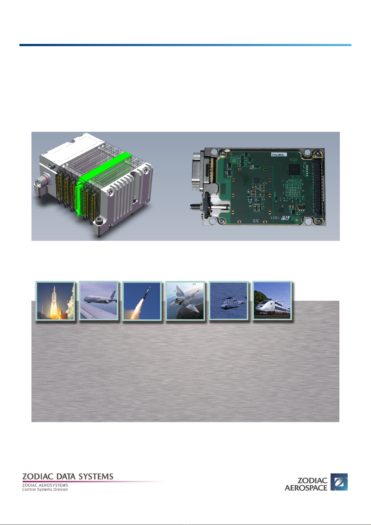
MUT100072E1R3 — 02 – 2019 i
TABLE OF CONTENT
TABLE OF CONTENT
1. INTRODUCTION . . . . . . . . . . . . . . . . . . . . . . . . . . . . . . . . . . . . . . . . . . . . . . . . . . . . . . . . . . . . . . . . . . . . . . . . . . . . . . 1
1.1 About this User’s Manual . . . . . . . . . . . . . . . . . . . . . . . . . . . . . . . . . . . . . . . . . . . . . . . . . . . . . . . . . . . . . . 1
1.2 General information . . . . . . . . . . . . . . . . . . . . . . . . . . . . . . . . . . . . . . . . . . . . . . . . . . . . . . . . . . . . . . . . . . 1
1.3 Reference Documents . . . . . . . . . . . . . . . . . . . . . . . . . . . . . . . . . . . . . . . . . . . . . . . . . . . . . . . . . . . . . . . . . 1
1.4 Safety . . . . . . . . . . . . . . . . . . . . . . . . . . . . . . . . . . . . . . . . . . . . . . . . . . . . . . . . . . . . . . . . . . . . . . . . . . . . . . . . 1
1.5 Installation, transportation, storage . . . . . . . . . . . . . . . . . . . . . . . . . . . . . . . . . . . . . . . . . . . . . . . . . . . 1
2. OVERVIEWS . . . . . . . . . . . . . . . . . . . . . . . . . . . . . . . . . . . . . . . . . . . . . . . . . . . . . . . . . . . . . . . . . . . . . . . . . . . . . . . . . . 3
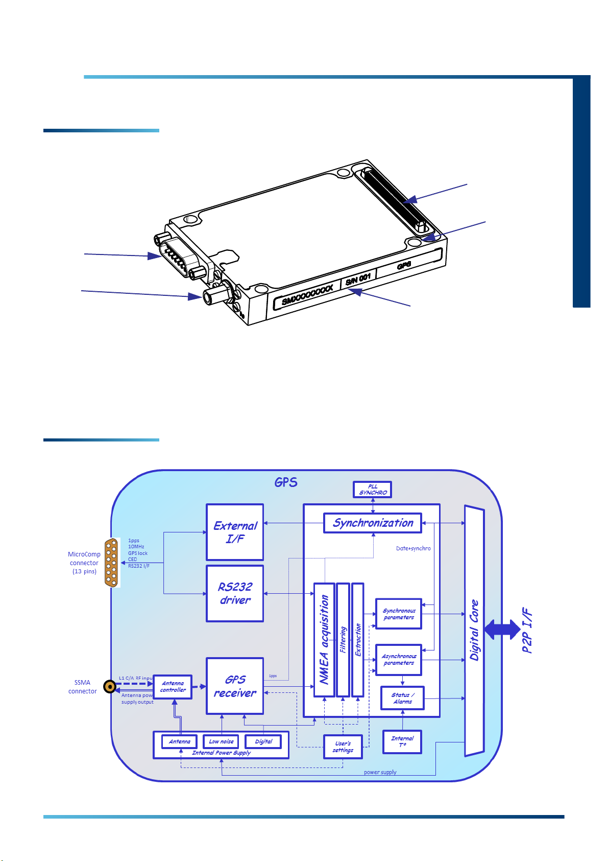
2.1 Physical overview . . . . . . . . . . . . . . . . . . . . . . . . . . . . . . . . . . . . . . . . . . . . . . . . . . . . . . . . . . . . . . . . . . . . . 3
2.2 Functional overview . . . . . . . . . . . . . . . . . . . . . . . . . . . . . . . . . . . . . . . . . . . . . . . . . . . . . . . . . . . . . . . . . . 3
3. OPERATION . . . . . . . . . . . . . . . . . . . . . . . . . . . . . . . . . . . . . . . . . . . . . . . . . . . . . . . . . . . . . . . . . . . . . . . . . . . . . . . . . . 5
3.1 Introduction . . . . . . . . . . . . . . . . . . . . . . . . . . . . . . . . . . . . . . . . . . . . . . . . . . . . . . . . . . . . . . . . . . . . . . . . . . 5
3.2 System Inventory . . . . . . . . . . . . . . . . . . . . . . . . . . . . . . . . . . . . . . . . . . . . . . . . . . . . . . . . . . . . . . . . . . . . . 5
3.3 Data Acquisition . . . . . . . . . . . . . . . . . . . . . . . . . . . . . . . . . . . . . . . . . . . . . . . . . . . . . . . . . . . . . . . . . . . . . . 8
3.3.1 Digital bus . . . . . . . . . . . . . . . . . . . . . . . . . . . . . . . . . . . . . . . . . . . . . . . . . . . . . . . . . . . . . . . . . . . . . 8
3.3.2 Digital message . . . . . . . . . . . . . . . . . . . . . . . . . . . . . . . . . . . . . . . . . . . . . . . . . . . . . . . . . . . . . . . . 8
3.4 Output data streams configuration . . . . . . . . . . . . . . . . . . . . . . . . . . . . . . . . . . . . . . . . . . . . . . . . . . 12
3.5 Compilation and verification . . . . . . . . . . . . . . . . . . . . . . . . . . . . . . . . . . . . . . . . . . . . . . . . . . . . . . . . 12
3.6 Configuration loading . . . . . . . . . . . . . . . . . . . . . . . . . . . . . . . . . . . . . . . . . . . . . . . . . . . . . . . . . . . . . . 12
3.7 System monitoring . . . . . . . . . . . . . . . . . . . . . . . . . . . . . . . . . . . . . . . . . . . . . . . . . . . . . . . . . . . . . . . . . 12
3.8 Quicklook . . . . . . . . . . . . . . . . . . . . . . . . . . . . . . . . . . . . . . . . . . . . . . . . . . . . . . . . . . . . . . . . . . . . . . . . . . 12
4. NMEA MESSAGE FORMAT . . . . . . . . . . . . . . . . . . . . . . . . . . . . . . . . . . . . . . . . . . . . . . . . . . . . . . . . . . . . . . . . . . . 15
4.1 Introduction . . . . . . . . . . . . . . . . . . . . . . . . . . . . . . . . . . . . . . . . . . . . . . . . . . . . . . . . . . . . . . . . . . . . . . . . 15
4.2 Message format . . . . . . . . . . . . . . . . . . . . . . . . . . . . . . . . . . . . . . . . . . . . . . . . . . . . . . . . . . . . . . . . . . . . 15
4.3 GGA – Global Positioning System Fix Data . . . . . . . . . . . . . . . . . . . . . . . . . . . . . . . . . . . . . . . . . . . . 16
4.4 GLL – Geographic Position – Latitude/Longitude . . . . . . . . . . . . . . . . . . . . . . . . . . . . . . . . . . . . . 17
4.5 GSA – DOP and Active Satellites . . . . . . . . . . . . . . . . . . . . . . . . . . . . . . . . . . . . . . . . . . . . . . . . . . . . . 18
4.6 GSV – Satellites in view . . . . . . . . . . . . . . . . . . . . . . . . . . . . . . . . . . . . . . . . . . . . . . . . . . . . . . . . . . . . . . 19
4.7 RMC – Recommended Minimum Specific GNSS data. . . . . . . . . . . . . . . . . . . . . . . . . . . . . . . . . . 20
4.8 VTG – Course Over Ground and Ground Speed . . . . . . . . . . . . . . . . . . . . . . . . . . . . . . . . . . . . . . . 21
4.9 ZDA – Time and Date . . . . . . . . . . . . . . . . . . . . . . . . . . . . . . . . . . . . . . . . . . . . . . . . . . . . . . . . . . . . . . . . 22
5. CONNECTORS . . . . . . . . . . . . . . . . . . . . . . . . . . . . . . . . . . . . . . . . . . . . . . . . . . . . . . . . . . . . . . . . . . . . . . . . . . . . . . 23
5.1 Introduction . . . . . . . . . . . . . . . . . . . . . . . . . . . . . . . . . . . . . . . . . . . . . . . . . . . . . . . . . . . . . . . . . . . . . . . . 23
5.2 Input/Output connector . . . . . . . . . . . . . . . . . . . . . . . . . . . . . . . . . . . . . . . . . . . . . . . . . . . . . . . . . . . . 23
5.3 RF connector . . . . . . . . . . . . . . . . . . . . . . . . . . . . . . . . . . . . . . . . . . . . . . . . . . . . . . . . . . . . . . . . . . . . . . . 23
6. TROUBLESHOOTINGS . . . . . . . . . . . . . . . . . . . . . . . . . . . . . . . . . . . . . . . . . . . . . . . . . . . . . . . . . . . . . . . . . . . . . . . 25
7. MAINTENANCE AND SERVICE . . . . . . . . . . . . . . . . . . . . . . . . . . . . . . . . . . . . . . . . . . . . . . . . . . . . . . . . . . . . . . . 27
7.1 Introduction . . . . . . . . . . . . . . . . . . . . . . . . . . . . . . . . . . . . . . . . . . . . . . . . . . . . . . . . . . . . . . . . . . . . . . . . 27
7.2 Maintenance . . . . . . . . . . . . . . . . . . . . . . . . . . . . . . . . . . . . . . . . . . . . . . . . . . . . . . . . . . . . . . . . . . . . . . . 27

ii GPS — User’s Manual
TABLE OF CONTENT
7.3 Service . . . . . . . . . . . . . . . . . . . . . . . . . . . . . . . . . . . . . . . . . . . . . . . . . . . . . . . . . . . . . . . . . . . . . . . . . . . . . 27
8. GLOSSARY . . . . . . . . . . . . . . . . . . . . . . . . . . . . . . . . . . . . . . . . . . . . . . . . . . . . . . . . . . . . . . . . . . . . . . . . . . . . . . . . . 29

MUT100072E1R3 — 02 – 2019 1
INTRODUCTION
1. INTRODUCTION
1.1 About this User’s Manual
This User’s Manual includes the informations necessary for the installation and operation of the GPS module. This
document describes external interfaces and how to configure this module with eZ Software.
Read this document completely before using this module.
1.2 General information
The GPS module is designed to acquire L1-C/A GNSS signal and to output a complete PVT (Position, Velocity, Time)
through synchronous and asynchronous parameters available for standard outputs (PCM, recorder, Ethernet …).
The GPS module provides system synchronization capabilities.
1.3 Reference Documents
1.4 Safety
Observing the safety instructions will help prevent personal injury or damage to the device. Therefore, carefully
read through and adhere to safety instructions before using this equipment. It is also absolutely essential to
observe the additional safety instructions on personal safety that appear in first chapter of [RD1].
1.5 Installation, transportation, storage
For unpacking, inspection and installation of the GPS module, refer to the related chapter of [RD1].
RD1 MUT300107 XMA/CMA-XS Series Basic Guide
RD2 MUT300059 XMA Series Assembly/Disassembly instructions
RD3 MUT300049 eZ Software User’s Manual
RD4 MUT300053 XMA/CMA-XS Serie Status Reference Manual
RD5 FTP300062 CMA-XS GPS Datasheet
RD6 FTP300063 XMA GPS Datasheet

2GPS — User’s Manual
Installation, transportation, storage
THIS PAGE IS INTENTIONALLY BLANK

MUT100072E1R3 — 02 – 2019 3
OVERVIEWS
2. OVERVIEWS
2.1 Physical overview
1. I/O Connector
2. RF Connector
3. Holes (x4) for stack mounting
4. Identification label
5. Internal connector (P2P)
2.2 Functional overview
For complete description of this module, refer to [RD5] or [RD6].

4GPS — User’s Manual
Functional overview
THIS PAGE IS INTENTIONALLY BLANK

MUT100072E1R3 — 02 – 2019 5
OPERATION
3. OPERATION
3.1 Introduction
This section provides all the information necessary to configure, monitor and control the GPS for operation using
eZ software. This chapter assumes DAU stack is correctly assembled and connected (Refer to RD1, RD2). eZ
software must be running, and the internal structure of the DAU must be defined in the System Inventory activity
(Refer to RD3).
3.2 System Inventory
▶Select System Inventory activity.
▶In the Devices tab, select the GPS module in the DAU (e.g. XMA-1). The GPS module configuration menu
appears on the right side.
Settings Values Comments
Informations
Name
Slot
Channels Type
Channels count
Not modifiable Informations about the configuration of the stack
GPS data source
Protocol Identical to Functional set Indicates the current protocol. Can be changed by modifying the
Functional set setting

6GPS — User’s Manual
System Inventory
Functional set ◆iTalk
◆NMEA
◆Enables GPS receiver to communicate with an external host
such as PC. It is a low level communication layer that allows
host to control the receiver and retrieve data from it.
◆The receiver produces and interprets messages in accord-
ance with NMEA 0183 V3.0 standard. It is possible to send
commands to drive the GPS receiver chipset and extract nav-
igation data. See NMEA chapter for more details.
Data source ◆Internal (Chipset GPS)
◆External (RS232 exter-
nal interface)
◆The data received by the internal GPS chipset are used.
The RS232 area is greyed and these parameters unmodifia-
ble.
◆External communication system must be connected to the
external interface . When External is selected, the RS232 area
becomes modifiable. Enter the serial link parameters to be
compatible with your own communication system.
RS232 configuration
Data rate (bps) Drop-list of available data-
rates
Word size (bits) 7, 8
Stop bit 0, 1, 1.5, 2
Parity None, Even, Odd
Signal Output
Clock output
format
◆Off
◆iNet
◆XMA
◆Modulated 10MHz
(IEEE1588-2002)
◆No clock signals on the outputs (TOP1PPS_TTL_OUT &
CLK10MHz_TTL_OUT).
◆TOP1PPS_TTL_OUT & CLK10MHz_TTL_OUT signals are avail-
able.
1PPS pulse width: 25.6µs
1PPS pulse rising edge aligned with rising edge of a period of
10MHz clock
◆TOP1PPS_TTL_OUT & CLK10MHz_TTL_OUT signals are avail-
able.
1PPS pulse width: 100ns
1PPS pulse rising edge aligned with falling edge of a period
of 10MHz clock
◆Only CLK10MHz_TTL_OUT signal is available.
The 10MHz signal is modulated by 1PPS signal according the
IEEE-1588-2002 standard.
Valid_FIX out-
put signal
◆Off
◆Normal, Inverted
◆No VALID_FIX signal on the output.
◆VALID_FIX signal is available. The logic table below describe
the polarity signal.
Status/Mode Normal Inverted
Locked 10
Unlocked 01
Antenna settings
Settings Values Comments

System Inventory
MUT100072E1R3 — 02 – 2019 7
OPERATION
Power Supply ◆Off
◆+3.3V
◆+5V
◆The GPS must be connected to a standard passive GPS
antenna.
◆The GPS must be connected to a standard active GPS
antenna needing 3.3VDC voltage. GPS delivers 3.3VDC /
50mA.
◆The GPS module must be connected to a standard active GPS
antenna needing 5VDC voltage. The GPS delivers 5VDC /
50mA.
GPS Chipset settings
Reset parame-
ters at start up
Checked, Unchecked Select parameters to be reset at start up or after a conditional
reset.
Conditional
reset on PDOP
criteria
◆Enable
◆Disable
◆Recommended for high level dynamics flights.
Some parameters need to be refreshed frequently to guar-
anty the quality of PVT data. Old parameters create many
perturbations and the PDOP value increased. When the
threshold value is reached the GPS send a reboot command
to the GPS chipset and refresh the parameters selected
above. The receiver relock in best conditions.
◆Standard mission. In case of a high value of the PDOP param-
eter, the internal GPS chipset will not be rebooted.
It is the recommended mode:
◇Where GPS antenna is not going to suffer sudden
changes of position
◇For smooth flights or flights presenting progressive
manoeuvrings
◇Where the GPS antenna has the visibility of the same set
of satellites or changes of its position are done progres-
sively
NOTICE!
Risk of damage to the device!
An internal current protection circuitry limit the DC current to 90mA.
Settings Values Comments

8GPS — User’s Manual
Data Acquisition
3.3 Data Acquisition
▶Select Data Acquisition activity.
3.3.1 Digital bus
▶Add a digital bus and name it (e.g. GPS_bus).
Refer to RD3 to learn how to add a digital bus
3.3.2 Digital message
▶Select a digital bus (e.g. GPS_bus previously created). The line must be underlined.
▶Click on [Add Message] button. A new window appears.
Four modes are available. TRANSPARENT, NMEA FRAME, NMEA PARAMETER and NMEA EXTRACTION.
Transparent Mode
Received NMEA frames are transmitted without modification.
Note:
You must create as many buses as GPS module contained in the DAU.

Data Acquisition
MUT100072E1R3 — 02 – 2019 9
OPERATION
NMEA Frame Mode
A filter can be activated to select one of the seven standard NMEA frames.
▶Select the frame type you want to extract (NMEA frame types are described in NMEA chapter).
NMEA Parameter Mode
Fixed extractions are activated to extract predefined parameters on several NMEA frames. With this mode, the user
can extract the following information:
Parameter name Bits field Parameter description
Latitude [31] course N=1/S+0
[30:22] degree [0;90]°
[21:16] minute [0;59]’
[15:0] decimal [0;9999]
Longitude [31] course E=1/W=0
[30:22] degree [0;180]°
[21:16] minute [0;59]’
[15:0] decimal [0;9999]
Altitude (MSL) [31:16] integer part [0;9999]m
[15:0] decimal part [0;99]
Date1[23:16] year [0;99]y
[15:8] month [1;12]m
[7:0] day [1;31]d
Time1[23:16] hour [0;23]h
[15:8] minute [0;59]min
[7:0] second [0;59]s
1/100e second [0;99]1/100s
Speed [23:8] integer part [0;9999]mps
[7:0] decimal part [0;99]
PDOP [15:8] integer part [0;99]
[7:0] decimal part [0;9]

10 GPS — User’s Manual
Data Acquisition
▶Once the desired parameter selected, the user can choose the different following options:
■Refresh Mode
Defines the method to output the parameter from GPS module.
□Synchronous: Parameter is sent periodically with a rate of 1Hz.
□Asynchronous: Parameter is sent after its extraction in the corresponding NMEA frame
■Endianess
Describes the order of byte transmission over a digital link.
□Big Endian: The most significant byte is send first. (Most common format).
□Little Endian: The least significant byte is sent first.
■Base (only for Date, Time and Date & Time predefined parameters)
Describe the data format.
□Binary format
□BCD format
■Date&Time format (only for Date & Time predefined parameter)
□XMA
□GPS
□IRIG-106 Chapter 4
■Length (for information)
□Date & Time predefined parameter:
- XMA: 48 bits
- GPS: 64 bits
- IRIG-106 Chapter 4: 64 bits
□Other predefined parameters: 32 bits
VDOP [15:8] integer part [0;99]
[7:0] decimal part [0;9]
HDOP [15:8] integer part [0;99]
[7:0] decimal part [0;9]
#Sat used [7:0] # satellite [0;32]
#Sat viewed [7:0] # satellite [0;32]
ValidFix [7:0] state 1=no fix / 2=2D / 3=3D
Height of geoid [31:16] integer part [0;9999]m
[15:0] decimal part [0;99]
1. The output format of DATE and TIME parameters can be considered via a single DATE&TIME parameter
based on the IRIG-106 Chap.4 (48 bits) format or on the XMA (48 bits) format - conversion from data fields
DATA and UTC TIME extracted from the NMEA frame.
Each parameter correspond to a 32-bit word (except dor Date&Time)
Note:
This parameter has impact over the compatibility with output data streams.
For more details, refer to the Output Data Stream Chapter of RD3.
Parameter name Bits field Parameter description

Data Acquisition
MUT100072E1R3 — 02 – 2019 11
OPERATION
NMEA Extraction Mode
This mode allows to extract any field of any NMEA frame type.
▶Select the NMEA frame type in which you want to extract a field.
■Refresh Mode
See NMEA Parameter Mode
■Endianness
See NMEA Parameter Mode
■Base
□Binary format
□BCD format
□IEEE-754 Floating point format (Refer to the IEEE website for more details: http://standards.ieee.org)
■Position
Select the position of the field to extract in the NMEA frame (Position 1 means the first field after the NMEA
frame header). See ⇨ NMEA MESSAGE FORMAT – page 15 for details on NMEA position parameters.
■Multiplier
To facilitate the reading of the result, a multiplier can be applied on the extracted field.
■Length (for information)
□32 bits
It is possible to define up to 64 extractions.

12 GPS — User’s Manual
Output data streams configuration
3.4 Output data streams configuration
You can define your DAUs output data streams to integrate acquired GPS parameters.
Refer to OUTPUT DATA STREAMS chapter of RD3 to configure correctly the data streams.
3.5 Compilation and verification
Refer to COMPILATION AND VERIFICATION chapter of RD3 to check the integrity/feasibility of user requirements
versus hardware capabilities, and to generate binaries that may be loaded in devices internal memory.
3.6 Configuration loading
Refer to CONFIGURATION LOADING chapter of RD3 to load the compiled configuration into the flash memory of
the device.
3.7 System monitoring
In operational mode, the System Monitoring activity show you the real time GPS status and acquired parameters.
▶Select System Monitoring activity.
GPS status are presented in the following screen capture. For more details, refer to GPS MODULE chapter of RD4.
The content of a digital bus message is displayed in the Raw data preview window.
Only one message can be displayed at a time, if you want to display all messages, use the Quicklook activity.
3.8 Quicklook
This activity allows to record and display the parameters.
▶Select Quicklook activity.
▶Click on [Add parameter] button and select the parameter to display.
Values of each parameters are displayed in real time, in the Raw Data column.
▶Click on [Start] Button to record the data.

Quicklook
MUT100072E1R3 — 02 – 2019 13
OPERATION
▶Click on [Stop Acquisition] button to stop recording.
Refer to QUICKLOOK chapter of RD3 for more details.

14 GPS — User’s Manual
Quicklook
THIS PAGE IS INTENTIONALLY BLANK

MUT100072E1R3 — 02 – 2019 15
NMEA MESSAGE FORMAT
4. NMEA MESSAGE FORMAT
4.1 Introduction
This chapter contains extracts from the standard describing the NMEA message format and syntax available for the
GPS module.
For more detail see the website www.nmea.org.
4.2 Message format
All NMEA message and command data consist of ASCII characters (from 20-127 decimal or from HEX 14 to HEX 7E).
For further information see section 6.1 (Table3) in NMEA 3.0 specification.
NMEA messages consists of fields as follows:
$GP<message id>,<data field>,<data field>,,,,,*<checksum><CR><LF>
Fields are separate by commas.
Message starts with an identifier field and ends after the delimiter ‘*’ with checksum, carriage return <CR> and line
feed <LF> control characters.

16 GPS — User’s Manual
GGA – Global Positioning System Fix Data
4.3 GGA – Global Positioning System Fix Data
Time, position and fix related data for a GPS receiver.
Syntax:
$GPGGA,hhmmss.sss,xxmm.ddddd,<N|S>,yyymm.ddddd,<E|W>,v,ss,dd.dd,hhhh.h,M,g.g,M,a.a,xxxx*cs<CR><LF>
Example:
$GPGGA,084053.39,6016.3051,N,02458.3735,E,0,00,0.0,46.6,M,18.2,M,,*5D
Position Parameter Format Designation / Units
1hhmmss.sss UTC time of the fix.
hh = hours
mm = minutes
ss = seconds
sss = decimal part of seconds
2xxmm.ddddd Latitude coordinate
xx = degrees
mm = minutes
ddddd = decimal part of minutes
3<N/S> Character denoting either N = North or S =South.
4yyymm.ddddd Longitude coordinate
yyy = degrees
mm = minutes
ddddd = decimal part of minutes
5<E/W> Character denoting either E = East or W = West.
6vFix valid indicator
0 = Fix not valid
1 = Fix is valid
7ss Number of satellites used in position fix, 00-12
8dd.dd HDOP - Horizontal Dilution Of Precision.
9hhhh.h Altitude (mean-sea-level) in meters
10 M Letter M
11 g.g Geoid in meters
12 M Letter M.
13 a.a (not implemented)
14 xxxx (not implemented)
Table of contents