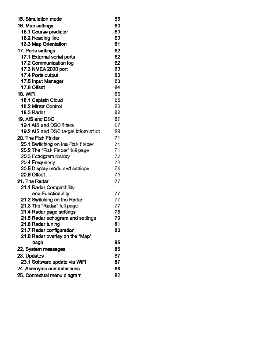
Alphatron Marine Pro Line FF-901 User manual

)
Pro
Li~e
FF-901
ALPH~TR
e
N
Marine
Chart
plotterI
Fish
finder
User
Manual
aIphatron
mari
ne.com


Table
or
Contents
1.
lnlroducllon 5 8.3 Route following 33
1.1
Conventions used 5
8.3.1
Route following options 34
1.2 Keyboards 5 8.3.2 Route following optimization 35
1.3
Touchscreen gestures 6 8.4 Assisted Routing: Easy Routing or
1.4 Software interaction 7 Autorouting 35
2.
On Board user manual 8
8.4.1
C-Map Easy Routing 35
3.
Getting started 9 8.4.2 NavionicsAutorouting 36
3.1
Switching
on
9
9.
UserData 38
3.2
SWitching
off 9
9.1
Marla! 38
3.3 Initial Settings 9
9.1.1
Adding a new mark 39
3.4 Selecting the software language 9 9.1.2 Editing mark's color, symbol,
3.5 Selecting !he chart language 9 name and description 39
3.6 Setting units, time zone 9.1.3 Editing mark's position 40
and time format
10
9.1.4 Marla! displaying
on
lho map 40
4.
Controlling the display
11
9.2 Routes 40
4.1
Status bar
11
9.2.
1 Creating a new route
41
4.2 The "Map" page
12
9.2.2 Editing route's name
4.3 The "Fish Finder" page 13 and description
41
4.4 The "Engine" page
14
9.2.3 Planned route speed
41
4.5 The "Radar" page 15 9.3 Waypoinls 42
4.6 The split pages
16
9.3.1 Editing waypoint's position 42
4.
7
Data
boxes customization 18 9.4 Tracks 43
5.
Mapa:
Using C-Map 4D,
9.4.1
Editing track's color, name,
and
C-Map
Max,
and Navionics 19 description 43
5.1
Moving around the map 19 9.4.2 Setting up a track generation
5.2 Finding your boat position 19 interval and color logic 43
5.3 Chart Info and Quick Info 20 9.4.3 Converting track to route 44
5.4 Overzoom
21
9.5 Boundaries 44
6.
Quick Settings 22
9.5.1
Creating a boundary 45
6.1
Quick Settings with C-Map 9.5.2 Editing boundary's color, name
(4D
or MAX) 22 and description 45
6.2 Quick Settings with Navionics 23 9.5.3 Boundary alann 46
9.5.4 Vertices 46
7,
General Settings 25 9.6 Locate user data on the map 46
7.1
Export/import of user settings 25
9.
7 Changing userdata default color,
7.2 Keyboard
and
function keys symbol or prefix 47
settings 26 9.8 Displaying user data 47
7.3 Navigation settings 27 9.9 User data fillers 47
7.4 Display settings 28 9.10 Order ofuser data on the page 47
7.5 Ship Profile settings 29
9.11
Exporting/importing userdata 48
7.6 Loran-e 29 9.12 Deleting user data 49
7.7 Easy Routing orAutorouting
Settings
30
10. A-B function 50
7.8 Internal GPS settings 30
11.
Search function
51
8.
Go
To
function
31
12.
lldes
information
52
8.1
Navigation to a single destination
31
13.
MOB
54
8.2 Creating a route
32
14.Aiarms 55

15.
Simulation
mode
58
16. Map settings 60
16.1 Course prediclnr 60
16.2 Heading line 60
16.3 Map Orientation
61
17. Ports settings 62
17,1
External
serial
ports
62
17.2
Communication
log
62
17.3 NMEA2000
port
63
11.4 Ports output 63
11.5 Input Manager 63
11.6 Offset 64
18. WiFi 65
18.1 Gaplain Cloud 65
18.2 Mirror Control 66
18.3 Radar 66
19. AIS and DSC 67
19.1 AIS and DSC fillers 67
19.2AIS
and DSC large! information 69
20. The Fish Finder
71
20.1
Switching
on
the
Fish
Finder
71
20.2 Tho "Fish Finder" lull page
71
20.3 Echogram history 72
20.4 Frequency 73
20.5
Display
mode
and
settings
74
20.6 Offset 75
21. The Radar 77
21.1
Radar Compatibility
and
Functionality
77
21.2 Switching on the Radar 77
21.3 The "Radar" full page 77
21.4
Radar
page
settings
78
21.5 Radar echogram and settings 79
21.6 Radar luning
81
21.7
Radar
configuration
83
21.8 Radar ovenay on !he "Map"
page 85
22. System massages 86
23. Updates 87
23.1
Software update via WiFi 87
24.
Acronyms
and
definitions
88
25.
Contextual
menu
diagram
92

1.
Introduction
The plotter is a computerized electronic chart system, designed
as
a navigation aid. This manual
describes
the
core functionality
of
the software for marine plotters and is valid for different plotter
families, including 9" touchscreen.
The plotter integrates
GPS
data with digital charts stored on a micro SO card and can display
additional information from AIS, Fish Finder, and other sensors. Navigating through the plotter
pages is possible using eitherkeyboard
or
touchscreen.
1.1
Conventions used
Plotters can
be
controlled using only hardware keys
or
both hardware keys and touchscreen
operations.
In order to distinguish between hardware keys, menu items, buttons, icons, touchscreen and key
operations, thefollowing mapping is used:
·[POWER],
[MENU]·
hardware keys are given capitalized and enclosed in square brackets;
• "General Settings", "OK" • menu items and buttons (displayed on the screen) are enclosed
in
quotes;
·The
words "press", "release" mean operation with hardware keys, located on plotters;
•
The
words"tap","swipe" mean operation with menu items, buttons, lists, iconson touchscreen
plotter;
•
The
word "select" means choosing an item
in
two
ways:
1.
using ajoystick/joypad
or
a rotorwheel
to
highlightan itemand[ENTER] keyto select
it;
2. using tapgestures fortouchscreen plotters.
1.2 Keyboards
Figure
1.2-
Example
of
touchscreenplotter
Differentplotterfamilies have varied set of hardware keys.
Somekeys arecommon forall plotters; you can seetheirdescription below.
• Thejoystickljoypad can move the cursor around the map (pan the map)
or
through menu items.
Press [UP], [DOWN], [LEFT] or[RIGHT]. From nowon
we
referin a generic waytojoystick also
to
indicatethejoypad;
• Function keys like [F1] are special keys. Each key can perform
two
functions. A short press
performs the
fiXed
function (itcan belabeled on theunitface).A long press (press a key and hold
it)
executes
asecond functionthat can becustomized
by
theuser. Thisgivesyoua widerscopeof
User
Manual
5

functions that
can
be
executed
by
pressing function
keys.
See
Par.
7.2
to
learn
how
to
customize
the
function
keys;
-
[MOB]
is
a special
key
dedicated to man-over-board situation. Pressing
"MOB"
places a
MOB
mark
on
the current boat position
and
starts navigation to that
place;
-
[MENU]
opens
the
main
menu
if
pressed
on
one
of
the
main
pages
("Map",
"Fish
Finder",
"GPS
Status",
"Engine
Monitor
Display'').
Also,
from
a
listing
page,
such
as
"Marks",
"Routes",
"Tracks",
etc.,
pressing
MENU
moves
the cursor
to
the control buttons
located
at the
top
bar of
the
page;
-
[ENTER]
is
used
to
confirm
an
action
oraselection.
When
on
the
"Map"
page,
pressing
[ENTER]
opens
the
contextual
menu
ofa
map
object;
-
[CLEAR]*
exits
from
the
current
menu
or,
if
you
are
on
the
"Map"
page
and
the
cursor
is
away
from
the
boat
position,
centers
the
map
on
the
boat position
(home
mode);
-
[POWER]
turns the plotter on/off
when
pressed
and
held
in.
Short
press
allows switching day/
night
mode
of
the
screen
or change
the
brightness
and
disable touchscreen, depending
on
the
plotter
family.
*[CLEAR] may also refer to [BACK] or [CLR].
1.3 Touchscreen gestures
/)
Tap
(touch the screen for less than 1 second
and
release your finger): Perform
action corresponding to touch area ofthe screen: select, activate button,
etc.
/)
Long
tap
(touch
the
screen
and
hold
your finger for
more
than
1
second):
Open
editable
item,
e.g.
databox.
0
Pan
(touch
the
screen
on
the
"Map"
page,
keep
yourfinger
pressed
and
move
in
any
direction):
Pan
the
map.
~
Pinch
in
I
Pinch
out
(touch
the screen with
two
fingers
simultaneously,
then
move
fingers closer orfurther): Zoom-in I zoom-out
on
the
"Map"
page
orchange the
range
on
the
"Fish
Finder''
page.
79
Rotate
(touch
the
screen
with
two
fingers simultaneously
and
move
them
clockwise or
counterclockwise):
Rotate
the
map.
d
Scroll
up-down
orleft-right
(touch
the
screen
and
move
yourfinger
to
the
sides):
Scroll
through
the lists or
through
Fish
Finder
echogram
history.
G
~
Swipe
(touch
the
top edge ofthe screen with one
finger,
keep
it
pressed
and
move
quickly
to
the
bottom):
Open
page
selector.
~
~
Two
finger
drag
up
and
down:
Change
from
20
to perspective
mode
and
adjust
angle,
and
back
to
20
with C-Map MAX or
C-Map
40
cartography.
For
using
this
option
with
Navionics select
30
chart
mode
in
the
"Quick Settings"
menu.
6
User
Manual

1.4Software interaction
Your plotter will display various interface elements, such
as
icons, buttons, switchers, sliders and
radio buttons while operating the device, and these allowyou to set and control it.
Icons
Icons, such
as
"Back", "Home", "Close", helptoeasenavigation amongstmenusand dialogwindows.
The [CLEAR] button
is
used
to
return one step backwards
or
to
dose
a menu I popup
or
you can
tap the needed icon directly.
Buttons
Buttons, such as "OK", "Save",
·cancel"
are displayed in dialog windows and during userdataedit
mode.
Button selection is performed with the joystick and [ENTER] button: the desired button can be
targeted with thejoystick, while pressing [ENTER] confirms the selection.
Otherwise the tap gesture, directlyon the desired button, performs both targeting and confirmation
actions
at
once.
Swltchars
Enabling
or
disabling switchers can be doneusing joystick to targetthe item and pressing [ENTER]
to enable
or
disable the switcher.
Otherwise the tap gesture, directly
on
the desired item, switches between enabled and disabled
states.
Sliders
Sliders help
to
selectand change numericsettings. Valuescan
be
changed using theslideritself,
or
by
opening the virtual keyboard
to
enterthevalue manually.
Using the hardware keys:
1.
Use the joystick
to
targetthe slider;
2.
Press [ENTER] to activatethe slider knob:
it
will change the colorto blue;
3. Movethe sliderknob with the joystick
or
the rotorwheel
to
changethe value;
4. Press [ENTER] again
to
confirm thevalue;
or
5. Press [CLEAR] to cancel.
To
open the virtual keyboard, target
to
the slider and long press [ENTER].
Using the touchscreen:
1.
Tap the slider bar to move the knob and change the value;
2.
or
3. Tap the knob, and keep your finger pressed, moving right
or
left
to
change thevalue;
or
4. Tap the numericvalue
to
open thekeyboard.
Radio
buttons
Almost all the submenus consist of radio button groups. Only one radio button per group can be
selected. Selection
is
performedwithjoystickand [ENTER] buttons,
or
by
simplytappingthe needed
item to select it.
User
Manual
7

2.
On
Board
user
manual
This usermanual is built into the plotter software.
You can find it asthe lastitem in the main menu
of
each page:
1. Open the main menu
by
pressing [MENU];
2. Select "User Manual".
Howto read the manual
1.
Press [UP-DOWN]
or
usescroll gestureto scroll the page;
2.
Press [LEFT-RIGHT]
to
go
to the previous
or
the next page;
3. Press [ZOOM IN-ZOOM OUT] use rotor wheel
or
pinch in I pinch
out
gesturesto zoom
the page;
4. Press [ENTER]
or
use long tapgestureto find a page
by
number;
5. Press [CLEAR]
or
tap the "Home" icon to close the manual.
Howto search a keyword:
8
1.
Press [MENU]
to
highlight the "Search" icon and [ENTER]
to
call a virtual keyboard,
or
tap the "Search" icon;
2. Type a keyword
in
the keyboard: use [UP-DOWN] and [LEFT-RIGHT]
to
highlight a
letter and [ENTER]
to
confirm selection,
or
tap the letters. After entering the keyword,
move the cursor
over
"Done" and press [ENTER] button,
or
tap it;
3.
The firstpage with the chosen keyword will be presented and the keyword highlighted;
4. Press [LEFT-RIGHT]
to
go
to
the previous
or
the nextpage containing the keyword;
5.
Press [CLEAR]
or
tap the "ClearSearch" icon to close the search
view.
User
Manual

3.
Gelling
sblled
3.1 Switching on
Before
powering
theplotter
on,
check
fur
the
conect
voltage
(1
()..35)
and
the
correct
oonnections
with
other
instrumenls.
Press
and
hold
[POWER]
to
tum
on
the
plotter.
3.2 Switching off
Press
and
hold
[POWER]ID
IMiitch
the plotlar
off.
A
counldov.n
timer appears
on
the
saeen. If
you
release
[POWER]
before
1he
counldol.ln
timer
reaches
zero,
1he
plotter
'Nill
remain
switdled
on.
3.3 Initial Settings
When
turning
the
plotter
on
for the first
time,
you
can
change
main
settings
on
"Initial
Sellings" page
('t.anguage",
"Unils",
"Formats
and Referet
ICeS",
"Dale
and
lime",
"Engine
Setup"
and
"Ship
Profile").
"Initial
Setlings" page
'Nill
be
also
displayed
alter
restoring
ID
factory
default
settings
(Par.
7.1
).
This
page
allows
selecting
software
language,
unils, dale
and
time
format.
position
formatand
engines
number.
1.
Switch the plotteron andwaitfor the "Initial Settings" page
to
appearonthe screen;
2.
Select the preferred
item
by pressing [DOWN] I
[UP]
or
tap with your finger.
It
is possible
to
keep thedefault value;
3.
Press [ENTER]
or
tap
to
confirm the selection;
4.
Press [CLEAR], tap"Back" icon
of
thesubmenu
or
tapoutside the submenu
to
return
to
"Initial
Settings" items list;
5.
Afterintroducing all desired changes, select"Confirm";
6.
On
the
Warning-
LIMITATIONS
ON
USE"
page
press
[DOWN]
or
scroiiiD
read
the
limitations
on
use;
7.
Press [ENTER]
or
tap
"OK"
when
you
reachthe end
of
the
text
to
acceptthe limitationson use.
NOTE:
You
mustaccept
all
the
limitations
specification
on
the "Warning-
LIMITATIONS
ON
USE"
page
in
ortler
to
use
the
plotter.
3.4Selecting the software language
To
setthe
main
language
ofsoftware:
1.
Open
the main menu by pressing [MENU];
2.
Select"General Settings"> "Language•, then select the preferred language.
3.5 Selecting the chart language
To
change
the
language
ofthe
map
information,
fur
example,
names
of
geographical
objects:
With
C-MAP
4-D
and
C-MAP
MAX
default cartography:
1.
Open the main menu by pressing [MENU];
2.
Select "Map Settings" > "Chart Settings" > "Language", then select the chart language from
the list.
User
Manual
9

With Navionics default cartography:
1.
Open
the main
menu
by pressing [MENU];
2. Select "Map Settings" > "Chart Language", then select the chart language from the list.
3.6 Setting units, time zone and time format
To
change
unils:
1.
Open
the main
menu
by pressing
[MENU);
2. Select "General Settings" > "Units";
3. Select
an
option for
each
set
of
units.
To
change
lime
:zooe:
1.
Open
the main
menu
by pressing [MENU];
2. Select "General Settings" > "Date
and
Time";
3. Choose between "UTC" or "Custom"
(can
be adjusted after"UTC" setto
OFF).
If
you
chose
"Custcm:
1.
Select
the
desired zone from the "Custom" submenu;
2. Select "Daylight Saving
lime"
(it must be enabled/disabled manually).
To
change
date
and
time
format
1.
Open
the main menu bypressing [MENU];
2.
Select "General Settings" > "Date
and
lime";
3.
Choose the dateformat and
the
time format.
10
User
Manual

"
Controlling
lhe
diSIIIIJ
The plotterdisplays 6 main pages:
-"Map"
(Par.
4.2);
-"Fish Finder"
(Par.
4.3);
-"Engine"
(Par.
4.4);
-"Radar" (Par. 4.5);
-Split"Map I Fish Finder" page
(Par.
4.6);
-Split"Map I Radar" page
(Par.
4.6).
To
change
the
displayed page:
1. Open the main
menu
by
pressing )MENU];
2. Select"Page";
3.
In
the
widget popup, selecttha desired page using ajoystick
cr
tap the
needed
one.
Figure 4 -Pages widgetpopup
--
_o
•
--·--
•
NOTE: Changing pages
on
the touchscreen plotisrs can be dona also by vertical swipe (from the
top)
to
call a
page
widget.Aquickerwayto switch between pages is
to
setone
of
thefunction keys
(Par.
7.2)
to
"Page".
As
well, some models
of
plotter
can
alsohave a
[PAGE)
key
for
switchingpages.
4.1
Status
bar
The statusbarappears in the upperleftpart
of
thescreen on everypage.
It
can displayverious icons:
-WiFi connection status
and
thewirelesssignalstrength;
-GPS statusdepending
on
the
quality
of
satellite data;
-Remote controllerconnection status;
-Fish Finderconnection status;
-Captain
Cloud
connection status.
User
Manual
11

.4>-
43°2
3
.9
1
69
'N
'V
6°56.8714
'E
11.
6°
1
0.7
52
NM
Figure4.2.a -
Map
page
kn
ft
12:52
The
"Map"
page
includes
map,
cursor
box,
dalabcxes
map
mode
switch
icon
and
wheel
mode
switch icon.
~
Quick
Settin
gs
83
Page
kn
~
Search
~
R
outes
/V
Tracks
~
Marks
~
Bounda
ries
Figure4.2.b
-Map
page
menu
12
User
Manual

The
cursor
box
appears
on
the bottom left
of
the map and shows the Lat/Lon
In
home mode,
additionally itshows DSTand BRG when in cursor mode.
Thedataboxesare displayed
on
theright
part
of
the
screen, itscontentcan
be
customized (Par. 4.7).
Map
mode switch Icon displays thecurrentortentaUon
of
themapas:
-North Up(NU);
-Head Up(HU);
-Course Up (CU).
The
ortentaUon
of
themapcan
be
changed
by
tapping theIcon
or
from the main menu (Par. 16.3).
Press [ENTER]
or
long tap the map
to
open the cursor contextual menu, and [CLEAR]
or
tap
elsewhere
to
close it.
Press[MENU]
to
open the main menu
of
the
"Map"page.
4.3
The
"Fish Finder'' page
Figure4.3.a
-Fish
Finder
page
(simulation mode)
The
"Fish Finder" page can
be
available:
-
If
aBlack
Box
Fish Finder
accessory
Isconnected
to
theplotter;
-Withoutotherconnections in case
of
comboplotters.
Formore details aboutthe Fish FinderseePar. 20.
Press[MENU]
to
open the main menu
of
the
"Fish Finder" page.
User
Manual
--
_o
•
--·--
.
13

-!!o~
Tx
Settings
...)
} I
::
~
Offset
@
Transducers
List
go
General
Settings
~
System
Messages
~
Port
s
and
Connectivity
Figure 4.3.b
-Menu
on
the Fish Finder
page
4.4
The
"Engine"
page
- -
_o
.
--
·
--
.
kn
The
plotter
can
be
connected
through
CAN
bus
to
compatible
NMEA
2000
englne(s).
to
display
engine
state
and
performance.
14
,,l
l,
,,
,, , 4 ' 1,
,'
3 x1000 5
"'.,
6'
-::
-
7
::..
R
,·
75
00
s,
,'
,,
\I
l!f I,11
,'
' 3 x1000 5 ",..,
6'
-::
-
7
::..
RP
,·
75
00
s,
,'
Figure
4.4
-The Engine
page
User
Manual

Depending
on
the
number
of
engines,
the
"Engine•
page
will look
differently.
For
each
engine
detected,
the
page
displays
engine
RPM
gauge,
engine
temperature,
fuel
tanks,
tiltlbim
and
alternator
potential
data.
The
"Engine"
page
settings
are
located
on
''Quick
Settings"
and
"General
Settings"
pages:
1.
Open
the
main
menu
by
pressing
[MENU];
2.
Select "Quick Settings" >"Engine
Setup";
or
3.
Select "General Settings">
"Engine
Setup".
From
the
"Engine
Setup"
menu
you
can:
-setthe
number
of
engines,
to
be
displayed
on
the
page;
-set
max
RPM
value-
this
setting
will
be
applied
as a
limit
for
engine
RPM
gauge.
In
case
of
engine
alanns
the
following
notifications
may
appear:
Engine Alann Level1
(The
message cannot be
mute
ordismissed.)
Over-heated {in
case
of'Over Temperature' alarm)
Low
Oil
Pressure
Engine
AI
ann Level 2
(Touch
the
bartomute
the
alarm.
The
message stayson the screen until
the notification condition
is
over.)
Low
Battery
Voltage
Check Engine
Battery Charge
Water
In
Fuel
Rev
Limit
Exceeded
Engine EmergencyStop
Mode
NOTE:
A
Level-1
Engine
Alarm
can
be
ignored
but not
mute.
An
audible
alarm
is
active
for a
Level-1
Engine
Alarm,
even
if
the
buzzsr
is
set
OFF
in
the
alarm
settings.
NOTE:
the
SOG
gauge
limitcannot beset
from
this
menu.
It
depends
on
the
vessel
type:
for
each
type
the
SOG
limit
is
different.
You
can
change
the
vessel
type
in
"Ship"
settings
(Par.
7.5).
4.5 The "Radar'' page
The
"Radar"
page
displays
the
echo
from
the
radar,
if
a
compatible
antenna
is
connecled
to
the
plotter.
The
"Radar"
page
settings
are
located
in
the
main
menu
of
the
page.
For
more
details
see
Par.
21.
User
Manual
15

Figure
4.5-
The Radar
page
4.6 The
split
pages
A 41°
48.56
79'N
'V
6°5
4.514
1'E
~
182.4° I
89
.833
NM
\!1
Figure
4.6.a-
Example
of
the split
Map
I Fish
Finder
page
16
--
_o
•
--·--
•
User
Manual

The
splitpageIsa screen split between
the
"Map·and
the
"Fish Finder"
or
"Radar"pages. Each half
of
the
split
view
has
its
own
main menu.
When
you open
the
split page,
the
active view
is
always
the
"Map"
part.
In order
to
operate on
the
"Fish Finder"
or
"Radar"
part,
press [MENU] twice
or
tap
the
needed
part
of
the
page.
To open
the
contextual menu
on
the
"Map" part, press [ENTER]
or
long
tap
while
the
map
view is
active. To open
the
contextual menu on
the
"Fish Finder"
or
"Radar"
part,
press [ENTER]
or
long
tap
on
the
echogram.
Figure 4.6.b -
Example
of
the
split
Map
I Radar
page
User
Manual
17

CJI Use
Additional
Column
Ma1n Col
umn
Fi
x Position >
Course Over
Ground
>
Speed
Over
Ground
>
Time
>
Bearing
>
Figure
4.7-
Databoxesmenuon the
Map
page
The datawindow isa set
of
customizable databoxes. Itis presenton the
"Map",
"Fish Finder" and
"Radar" pages. The boxes may
be
set up to display various sensor data.
In
"Quick Settings• you
can selectto enable
or
disable data boxes
and
customize the number
of
columns and databoxes
content
To
customize databoxescontent on
"Map",
"Fish
Finder"
or
"Radar"
pages:
18
1.
Long
tap the databoxes:
2.
or
3.
Open
the
main
menu
by
pressing [MENU] and select"QuickSettings" > "Databoxes";
4. Enable "UseAdditional Column• todisplay two columns ofdataboxes:
5. Selectthe databox
from
main
and additional
column
and choose the preferred option
from the list;
6. Press
[CLEAR]
or
tap "Back" iconto rerum
to
thedataboxeslist;
or
7. Tap elsewhere
or
long press
[CLEAR]
to
exitdataboxesediting.
User
Manual

The plotter
has
a
built-In
'WOrld
background
map,
butfor
use
as
an
aid to
aafe
navigation,
C-Map
or
Navionics
detailed
maps
are
required.
The plotter
is
c::ompatible
with
C-Map
MAX,
C-Map
40
and
Navtonlcs
mapformats on micro
SO
cant.
Demlled
maps may
be
purchaaed
on
micro
SO
cards
from
either
C-Map
or
Navioni~
authorized
reseller$.
To
use
C-Map
(40
or
MAX)or
Navlonlce
detailed
maps,
Insertthe micro SD
cant
with
chart data
Into
the
micro
SO
slot
of
your
plotter.
NOTE:
After insefling the
C-Map
or
Navionics
micro
SO
card, the plotter
may
ask for a restart to
enable
chart usage.
5.1
Movingaroundthe
map
The map
can
be
&lQ)Iored
In different
ways.
Wheel
mode
8\Nitdlloon, located
on
the top right
of
the
saeennearthe map
mode
switch
icon,
shows
which mode isactive
now:
zoom,
rotata
ortilt.
To
changethemode
on
thetouchscteen
plotter,
tap
wtleel modeswitch icon
to
chooae
thepreferred
mode.
Depending
onthe
plotter,
touchscreen gestures
or
keyboard
can
be
used
to
movearound the
map.
®
@
@
Zoom mode
Use
joystickor
pan
gestureto
pan
the
map.
Use
!,ZOOM
IN)
and
!,ZOOM
OUl],
rctor wtleel
or
pinch
in
and
pinch out gestures
to
change themap scale sothata smaller
or
largerarea
18
shown
on
theMap page.
Rotate mode
Use
rotorwheel
or
rotategesturetorotate the
map.
nit
mode
Use
rotor wheel
or
two
flngers swipe
to
tilt the
map.
While
the map
18
Ulted,
ship
Icon
displayed as
an
anrcw.
Rotor
wheel actions depend onthe wtleel mode switch icon status.
On
thetouchscreenplotters,you
can
pan,
zoomin,zoom
out.
tilt
and
rotatethemap
with
touchSCfeen
gestures
in
each
of
the
modes.
The plotters
with
keyboards allow to
pan,
zoom
in
and
zoom
out the map using
hardware
keys
deaplte thewheel mode switch
Icon
S1atUe.
User
Manual
19

5.2
Finding
your
boat position
The
mostcommon use
of
the plotterIs
to
show
your
boars
currentlocation.
You
can
home
the cursor
to
the
boat using [CLEAR].
This
would center
the
map
view
on
the
boat
position and update
the
display
as
the
boatmoves.
On
touchscreen plotters you
can
also use "Backto Fix" icon, located
near
the
cursor
box
on
the
bottom leftpart
of
the screen.
The
"Own ShipOffset"function helps
to
keep
the
majority
of
the
area
in
front
of
the
vessel's position,
so
if
you
tum
on
this function,
the
plotterwill take into account
your
course
to
locate
the
boat
at
the
most comfortable position
on
the
map
relative
to
the
actual course.
To
tum
screen amplifieron/off:
1.
Open
the
main menu
by
pressing [MENU];
2. Select"General Settings" > "Ship";
3. Enable/disable
"Own
Ship
Offset"
option.
Use
the
joystick
or
tap gesture to move
the
cursor
away
from
the
boars
current position
and
exit
the
home
mode.
The
"Back
to
Fix
After
Timeout" function gets
back
to
home
mode, centering ship on
the
map
after
30
seconds time-out. You can switch thisfunction on/off:
1.
Open
the
main menu
by
pressing [MENU];
2. Select"General Settings• >"Navigation";
3. Enable/disable "Back
to
FixAfterTimeout".
Figure
5.3-
Object's QuickInfopopup
and
ChartInfo contextual
menu
on
the
Map
page
20
User
Manual
Table of contents
Popular Fish Finder manuals by other brands

Icom
Icom Marine Commander MXF-5000 instruction manual

Humminbird
Humminbird 343C Operation manual

Humminbird
Humminbird 997c SI Combo Installation and operation manual

Lowrance
Lowrance StructureMap HDS Gen 2 Guide

Yachting Electronic Co.
Yachting Electronic Co. FC80 user manual

Navman
Navman FISH 4200 Installation and operation manual