FishHunter DIRECTIONAL 3D User manual

THE MOST POWERFUL,
PORTABLE FISH FINDER
EVER.
A 5 transducer, Tri-Frequency,
wireless fish finder
that hunts fish to 160 ft (50 m)
and can be cast or trolled.
5 TRI FREQUENCY
TRANSUDCERS
3D BOTTOM
MAPPING
DIRECTIONAL
CASTING
3D BOTTOM
CONTOURING
TM
1
2
3
4
5
WELCOME TO
FISHHUNTER™ DIRECTIONAL 3D

2
30 DAY SATISFACTION GUARANTEE
We want you to be completely excited and satisfied with your new
FishHunter™ Directional 3D and we think you will be, but if for
some reason you are not, you have 30 days to return it for a refund
( not including shipping cost ).
Please keep the email confirmation you received when you placed
your order as this will be required to activate our
30 DAY SATISFACTION GUARANTEE or warranty claim.
For products that were not purchased directly from FishHunter,
please refer the the return policy for the location of purchase.
To submit a return please visit:
www.fishhunter.com/returns-process
For a warranty claim, please see page 38 in this guide.
TM

3
OVERVIEW
FishHunter™ Directional 3D is the most powerful fish finder ever
created for Apple and Android phones and tablets. The sonar floats
on the surface of the water and can be both cast and trolled behind
your boat or placed in your ice hole where it tracks water
temperature, water depth, bottom contour and fish locations.
The FishHunter™ Directional 3D wireless fish finder sonar
connects to your smartphone/tablet via Wi-Fi using our free soft-
ware APP, so you don’t need to have a cell tower connection or use
your cellular data to use your new fish finder.
Using our Free FishHunter™ Directional 3D software app, you will
also have the ability to access and store critical fishing information
like your favorite fishing spots, your catch details and share your
information with your friends and other fisherman.
If you would like more information on how to use your
FishHunter™ Directional 3D, you can also go directly to our
website where we have videos and additional content being
continuously updated.
www.fishhunter.com/support

4
FISHHUNTER™
FRONT
Night-time Fish Attraction
Illumination
Towing Point

5
2
14 5
3
BOTTOM
DIRECTIONAL 3D
5 Tri- Frequency Transducers
( 381KHz, 475 KHz, 675 KHz )
USB Charging Port

6
HOW TO CHARGE
Step 1: Located the 3 pin charging
port on the bottom of the sonar. It is
located on the opposite side from the
tow point eat the back of the sonar.
Charging yor FishHunter™ Directional 3D can be done
in 4 easy steps:
Step 2: Take the USB charge cord
from the box and hold the end that
has 3 pins holes in it.
Step 3: Push the USB cord into the
bottom of the sonar so that it fits
snug and the sonar lights up.
Step 4: Plug the USB cord into the
charger or any USB charger and a
light should appear on the top of the
sonar and stay on
For any additional questions please
see the video at:
www.fishhunter.com/support

7
95% OF THE FISH
ARE IN 5% OF THE WATER
KNOW WHERE TO CAST™

8
HOW TO CONNECT
Download the FishHunter™ app from the Google play or iOS app
store
Create and account inside the app by opening the app and
following the steps on the screen.
Ensure you have charged your FishHunter™ Directional 3D for
4 hours before first usage. You will know it is charged, because
a green light will appear in the top.
Connect your FishHunter™ Directional 3D to the braided line
on the end of your fishing line or tether it to the red leash that
was provided in your box by threading the red leash through the
tow point on the front of your FishHunter™ Directional 3D.
Drop the FishHunter™ Directional 3D into the water beside your
current position.
a. Please note, that in order for you to see your sonar
readings on your screen you will need to be in a minimum
of 4ft of water.
The unit will turn on when placed in water and will start slowly
flashing red from the top of the unit to let you know it is turned
on and ready for a connection.
Open your Wi-Fi settings and find “FishHunter™ 3D XXXX” on
the list of available Wi-Fi networks and select it. It may take up
to 1 minute for it to appear initially.
Wait for your phone/tablet to tell you that you are “connected” to
“FishHunter™ 3D XXXX” Wi-Fi
1
2
3
4
5
6
7
8

9
Now open your FishHunter™ app on your smart phone or tablet
and go to the “Sonar” section. Select FishHunter™
Directional 3D icon. Please note that Bluetooth will never apply
to this device and is only for our military unit.
a.Start Fishing: allows you to use sonar and offers you 4 view
modes. Please press on one of these modes to activate your
sonar.
i. Directional Casting
ii. 3D Bottom
iii. Bottom Mapping
iV. Ice Fishing
b.My Bottom Maps: Allows you to see any bottom maps you
created and saved within the FishHunter™ app.
c.Switch Device: Will disconnect your sonar from your phone
so another person/phone can connect to your sonar (only
appears if sonar is connected)
d. Demo mode: will allow you to see how the sonar will work
when not connected to a sonar.
The slow red flashing light on your sonar will start flashing
quickly when connected and sending information to your phone.
The unit will turn off when not in the water and power down. To
get it working again, just repeat steps 7 -10.
You can reset your sonar at any time by inserting the charge
cord into the bottom of the unit and removing it.
9
10
11
12
10
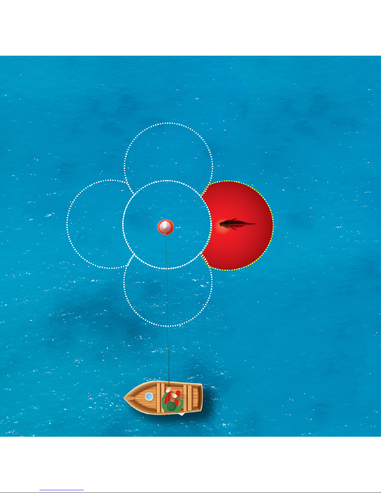
DIRECTIONAL CASTING™
10

11
Directional Casting™ powers up all 5 Tri-Frequency
transducers, showing you the depth and where the fish are
being detected in relation to your floating
FishHunter™ Directional 3D.
In this example, the right transducer is red, and the
number 13 appears. This indicates fish are on the right
side of your FishHunter™ Directional 3D, at a depth of 13
feet. Now cast in that direction and increase your chances
of catching more fish. Click on any of the 5 round icons and
you get a split view screen with the left side showing the
depth of any fish detected and the right side showing you
the exact bottom contour for the transducer you selected.
11
12
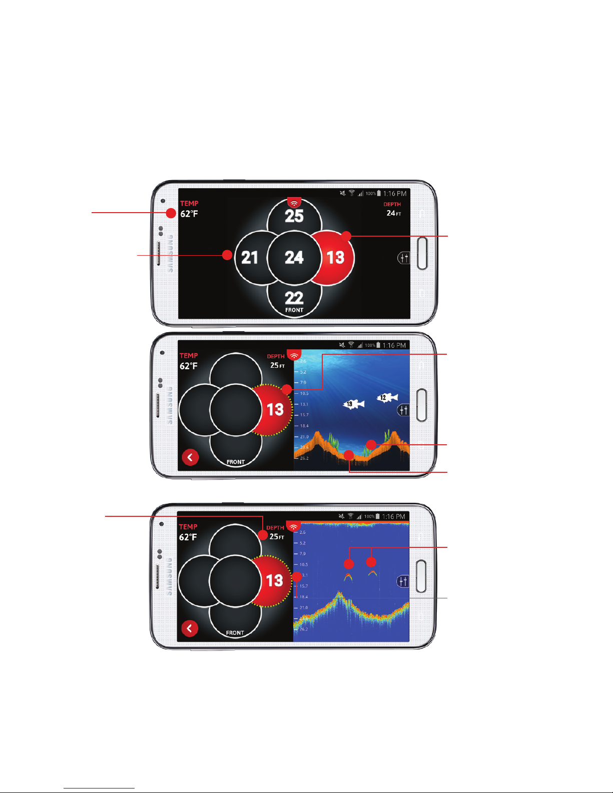
DIRECTIONAL CASTING™
Red circle
indicates fish
under that transducer
and its depth (13ft)
Touch the transducer
you are interested in,
and the screen
will be splited to
DIRECTIONAL VIEW
and FISH VIEW
Weeds
Bottom contour
Fish disturbances
in RAW VIEW
Water
temperature
Split screen with FISH VIEW
Split screen with RAW VIEW
Each circle is
one transducer
Depth to
the bottom
Red circle
indicates fish
under that transducer
and its depth

DIRECTIONAL CASTING™ STEPS
You must place FishHunter™ Directional 3D in water for it to
turn on (it must be in 4ft of water or more to work correctly).
Open your Wi-Fi settings and choose “FishHunter™ Wi-Fi”
Open the FishHunter™ app and go into the sonar section
Choose the “FishHunter™ Directional 3D sonar icon”
Choose “START FISHING”
Cast/drop FishHunter™ Directional 3D into the water at the area
you would like to map
Select “Directional Casting” icon within the FishHunter™ app
from your phone/tablet screen
Each of the round circles on the phone/tablet screen represents
one of the 5 transducers on the bottom of the
FishHunter™ Directional 3D
When you see those circles turn red with a number in it,
that means fish have been detected below that transducer with
the number being their depth
Now you know where the fish are and their depth in relation to
your floating FishHunter™ Directional 3D
Cast your line towards the area of the sonar that keeps lighting
up (turning red) to catch more fish
Want to see the raw sonar data from any of the 5 transducers?
Just press/touch on your phone/tablet screen on any of the
circles and see the transducer data on the right side of the
screen
1
2
3
4
5
6
7
8
9
10
11
12

14
3D BOTTOM CONTOUR MAPPING
Reel, drift or troll
14

15
You can create custom 3D Bottom Contour Maps of your favorite
fishing spots by placing the FishHunter™ Directional 3D
in the water and then reeling/drifting/trolling it over the area you
want to measure. Use the color coded scale to easily see drop offs
or toggle on/off the grid overlay to know exactly where the drop
offs are, their relative depth and distance.
Every 3D Bottom Contour Map is GPS tagged so you can save the
map and fish the same spot next time –no problem.
15

16
3D BOTTOM CONTOUR MAPPING
FRONT VIEW
SIDE VIEW
Color depth scale
Side scale
(Distance away from you)
Front or side view
selected from menu
Distance
across
Single colored bottom map
Distance
away

17
3D BOTTOM CONTOUR MAPPING STEPS
You must place FishHunter™ Directional 3D in water for it to
turn on (it must be in 4ft of water or more to work correctly)
Open your Wi-Fi settings and choose “FishHunter™ Wi-Fi”
Open the FishHunter™ app and go into the sonar section
Choose the “FishHunter™ Directional 3D sonar icon”
Choose “START FISHING”
Cast/drop FishHunter™ Directional 3D into the water at the
area you would like to map
Select “Bottom Mapping” icon within the FishHunter™ app from
your phone/ tablet screen
Follow the steps on the screen to create and save
a 3D Bottom Contour Map
1
2
3
4
5
6
7
8

18
3D BOTTOM CONTOURING
DEPTH TO
BOTTOM
DEPTH TO
FISH
47.6 ft
44 ft
18

19
Used to determine water bottom contour when in
a stationary position on the surface of the water.
Using 3D software and 5 Tri-Frequency transducers allows
us to create “life like” images of the bottom, so you can
quickly evaluate bottom contour.
Knowing the bottom contour when fishing is critical to
improving your catch rate and our cutting edge
3D Bottom Contouring technology provides a detailed view
of any underwater terrain.
19

20
Bottom depth shown
by different colors
MULTI COLOR
3D BOTTOM CONTOURING
SINGLE COLOR
Fish with depth Actual depth
Weeds appear in bright green
Bottom depth Pullout menu
Other manuals for DIRECTIONAL 3D
1
Table of contents
Other FishHunter Fish Finder manuals


