manuals.online logo
Brands
  1. Home
  2. •
  3. Brands
  4. •
  5. Garmin
  6. •
  7. GPS
  8. •
  9. Garmin Oregon 200 User manual

Garmin Oregon 200 User manual

Other manuals for Oregon 200

3

This manual suits for next models

6

Other Garmin GPS manuals

Garmin Alpha 100 User manual

Garmin

Garmin Alpha 100 User manual

Garmin Quest Reference guide

Garmin

Garmin Quest Reference guide

Garmin GPSMAP 4000 Series User manual

Garmin

Garmin GPSMAP 4000 Series User manual

Garmin GTN 725 User manual

Garmin

Garmin GTN 725 User manual

Garmin GPSMAP 175 User manual

Garmin

Garmin GPSMAP 175 User manual

Garmin GPSMAP 64sc SiteSurvey User manual

Garmin

Garmin GPSMAP 64sc SiteSurvey User manual

Garmin 400W Series User manual

Garmin

Garmin 400W Series User manual

Garmin cf Que 1620 User guide

Garmin

Garmin cf Que 1620 User guide

Garmin GPSMAP 4008 - Marine GPS Receiver User manual

Garmin

Garmin GPSMAP 4008 - Marine GPS Receiver User manual

Garmin MX20 User manual

Garmin

Garmin MX20 User manual

Garmin Street Pilot Street Pilot Atlantic User manual

Garmin

Garmin Street Pilot Street Pilot Atlantic User manual

Garmin EDGE 830 User manual

Garmin

Garmin EDGE 830 User manual

Garmin ZUMO 340 User manual

Garmin

Garmin ZUMO 340 User manual

Garmin GPS 150XL User manual

Garmin

Garmin GPS 150XL User manual

Garmin iQUE M5 User manual

Garmin

Garmin iQUE M5 User manual

Garmin ETREX 22X User manual

Garmin

Garmin ETREX 22X User manual

Garmin GPS 12 MAP User manual

Garmin

Garmin GPS 12 MAP User manual

Garmin Oregon 550t - Hiking GPS Receiver User manual

Garmin

Garmin Oregon 550t - Hiking GPS Receiver User manual

Garmin Apollo SL30 Manual

Garmin

Garmin Apollo SL30 Manual

Garmin affordable car navigation User manual

Garmin

Garmin affordable car navigation User manual

Garmin StreetPilot III User manual

Garmin

Garmin StreetPilot III User manual

Garmin GPSMAP 60Cx User manual

Garmin

Garmin GPSMAP 60Cx User manual

Garmin eTrex 10 User manual

Garmin

Garmin eTrex 10 User manual

Garmin ETREX Installation guide

Garmin

Garmin ETREX Installation guide

Popular GPS manuals by other brands

Polar Electro RCX3 Getting started guide

Polar Electro

Polar Electro RCX3 Getting started guide

Tobii Pro Spectrum user manual

Tobii Pro

Tobii Pro Spectrum user manual

Gosafe G91I user manual

Gosafe

Gosafe G91I user manual

Fisher TW-8800 operating manual

Fisher

Fisher TW-8800 operating manual

LG LN740 Series Specifications

LG

LG LN740 Series Specifications

Prestigio GeoVision 430 user manual

Prestigio

Prestigio GeoVision 430 user manual

JVC KW-NT3HDT instructions

JVC

JVC KW-NT3HDT instructions

Yoctopuce Yocto-GPS user guide

Yoctopuce

Yoctopuce Yocto-GPS user guide

RightWay GPS Navigator RW 200 user manual

RightWay

RightWay GPS Navigator RW 200 user manual

TomTom VIA user guide

TomTom

TomTom VIA user guide

Telit Wireless Solutions GM862GPS Series Hardware user's guide

Telit Wireless Solutions

Telit Wireless Solutions GM862GPS Series Hardware user's guide

Hama 53118 Operating	 instruction

Hama

Hama 53118 Operating instruction

Jigabot EX quick start guide

Jigabot

Jigabot EX quick start guide

Pointer Cellocator CelloTrack XT LTE overview

Pointer

Pointer Cellocator CelloTrack XT LTE overview

Queclink GV55LITE user manual

Queclink

Queclink GV55LITE user manual

Starcom Systems Kylos Compact user guide

Starcom Systems

Starcom Systems Kylos Compact user guide

Cobra Marine MC 600Ci owner's manual

Cobra

Cobra Marine MC 600Ci owner's manual

QRP Labs QLG2 manual

QRP Labs

QRP Labs QLG2 manual

manuals.online logo
manuals.online logoBrands
  • About & Mission
  • Contact us
  • Privacy Policy
  • Terms and Conditions

Copyright 2025 Manuals.Online. All Rights Reserved.

To navigate to a point using Where To?:
1. On the Main Menu, touch Where To?.
2. Touch a category.
3. Touch the item to which you want to navigate.
4. Touch Go. A colored line indicates your course.
5. Touch > Compass.
6. Use the compass to navigate to your destination.
To navigate to a point on the map:
1. On the Main Menu, touch Map.
2. Touch the point on the map.
3. Touch the information button at the top of the
screen.
4. Touch Go > > Compass.
5. Use the compass to navigate to your
destination.
To stop navigating, touch Where To? >
Stop Navigation.
To open the Compass page:
On the Main Menu, touch Compass.
Hold the compass level when
navigating.
The bearing pointer points to
your destination, regardless of
the direction you are moving.
If the bearing pointer points
toward the top of the compass,
you are traveling directly toward
your destination. If it points any other direction, turn toward
that direction until the arrow is pointing toward the top of the
compass.
Calibrate the compass after moving large distances, experiencing
temperature changes, or changing the batteries.
To calibrate the electronic compass (Oregon 300, 400t,
400c, and 400i):
1. While outdoors, hold the Oregon level and do not stand near
objects that inuence magnetic elds, such as cars, buildings,
or overhead power lines.
2. On the Main Menu, touch Setup > Heading > Press To Begin
Compass Calibration.
3. Touch Start and follow the on-screen directions.
Navigating to a Destination Using the Compass
May 2008 Part Number 190-00927-01 Rev. A Printed in Taiwan
Please visit www.garmin.com for additional documentation and
information.
Creating Routes and Using Tracks
To create and navigate a new route:
1. On the Main Menu, touch Route Planner > <Create Route> >
<Select First Point> to select a starting point.
2. Touch a category.
3. Touch the rst item on the route.
4. Touch Use > <Select Next Point>.
5. Repeat until the route is complete.
6. Touch to save the route.
7. Touch > Where To? > Routes to navigate the route.
To record your tracks:
1. On the Main Menu, touch Setup > Tracks > Track Log.
2. Touch Record, Do Not Show or Record, Show On Map.
If you select Record, Show On Map, a dashed line on the Map
page indicates your track.
To clear your current track:
On the Main Menu, touch Setup > Reset > Clear Current
Track > Yes.
Information button
Bearing to
destination
Direction you
are currently
traveling
Data elds
Oregon™series
quick reference guide
The Oregon operates on two AA batteries (not included). Use
alkaline, NiMH, or lithium batteries.
Use premium batteries for optimal performance and maximum
battery life. The best performance is provided by lithium batteries
and NiMH rechargeable batteries less than one year old with a
capacity greater than 2500 mAh.
To install the batteries:
1. Lift the latch and remove the
battery cover.
2. Insert the batteries,
observing polarity.
3. Replace the battery cover
and push the latch down.
NOTE: Remove the batteries when you do not plan to use the
Oregon for several months. Stored data is not lost when batteries
are removed.
To select the battery type:
1. On the Main Menu, touch Setup > System > Battery Type.
2. Select Alkaline, Lithium, or NiMH.
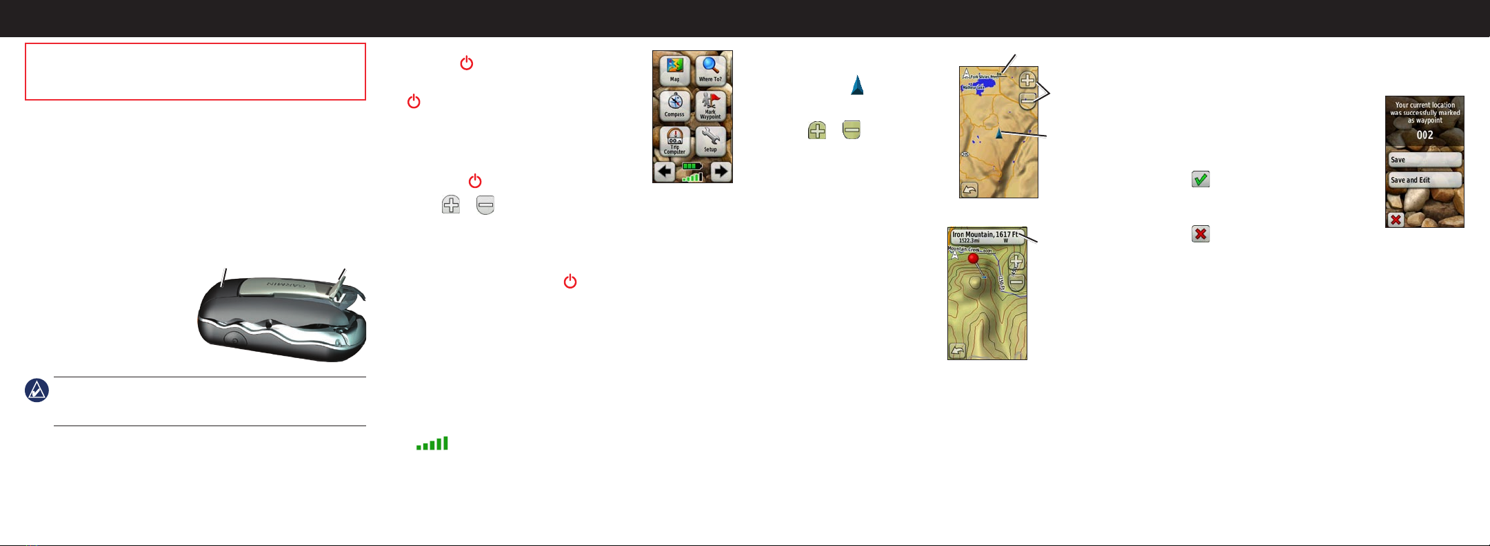
To access the Map page, touch Map.
Your current location is indicated by
a location marker .
To zoom in or out:
Touch or .
To pan across the map:
On the Map page, touch and drag
the screen.
To review detailed information about a point on the map:
1. Pan to the location you want to
review, if necessary, and then
touch it.
2. Touch the information button
at the top of the screen for
additional information.
To show or hide data elds:
1. On the Main Menu, touch
Setup > Map > Data Fields > Show Data Fields.
2. Touch Never, When Navigating, or Always.
To change the Map page data elds
1. On the Map page, touch one of the data elds.
2. Touch a data type.
Installing the Batteries
LatchBattery cover
Using the Map Page
Zoom
buttons
Location
marker
Zoom range
Getting Started
To turn the Oregon on:
Press the Power key.
To turn the Oregon off, press and hold the
Power key.
To adjust the backlight level:
1. While the Oregon is on, press and quickly
release the Power key.
2. Touch or to adjust the brightness
levels.
To lock or unlock the screen:
1. Press and quickly release the Power key.
2. Touch Lock Screen (or Unlock Screen).
To acquire GPS satellite signals:
1. Go outdoors to an open area, away from tall buildings and
trees.
2. Turn the Oregon on. Acquiring satellite signals can take a few
minutes.
The bars on the Main Menu indicate satellite strength.
When the bars are green, the Oregon has acquired satellite
signals.
Main Menu
To mark your current location as a waypoint and edit the
waypoint:
1. On the Main Menu, touch Mark Waypoint.
2. Touch Save and Edit.
Touch the attribute you want to change.
Touch letters, numbers, or symbols to
make the changes.
Touch (except when changing a
symbol). Change other attributes, if
necessary.
Touch .
To edit a waypoint:
1. On the Main Menu, touch Waypoint Manager.
2. Touch the waypoint you want to edit.
To delete a waypoint:
1. On the Main Menu, touch Waypoint Manager.
2. Touch the waypoint you want to delete.
3. Touch Delete Waypoint.
To reposition a waypoint to your current location:
1. On the Main Menu, touch Waypoint Manager.
2. Touch the waypoint you want to reposition.
3. Touch Reposition Here.
•
•
•
•
Creating and Editing Waypoints
See the Important Safety and Product Information guide in
the product box for product warnings and other important
information.
Information
button