Leica Virtual Wrench mojoRTK Administrator Guide

For more information:
www.mojoRTK.com
Page 1/10 Document #1022 rev1.8
HOW TO GUIDE:
Wayline Storage, pivot guidance, contour guidance
This document describes the setup and usage of the Wayline Storage
feature, pivot guidance and contour guidance. Each of these can be
enabled by entering a separate unlock code.
Description
The mojoRTK system provides guidance for a tractor:
along, and parallel to, a single straight line (the wayline)
around a circle about a central pivot and then at increasing
diameters to that pivot
along a defined path and then along the repeated path at offsets
to that path
The wayline storage feature allows the user to save and recall up to 100
stored waylines (20 may be contour waylines).
The stored waylines can be transferred between mojoRTK consoles
using a USB stick.
Benefits
Using Wayline Storage removes the need for the user to continually redo
the setting of their wayline when working with multiple waylines.
The ability to support straight line, pivot and curved guidance provides
operators with the primary navigation methods required for day to day
operation.
Limitations
For repeatability the base station must be placed in exactly the same
position as when the wayline was set. To avoid incorrect recall of waylines
only the waylines set with the base in the current position will be available
for recall. If the base has been moved at all and not replaced in exactly the
same spot then use of the mojo feature may
be required. For more information refer to the How To Guide - “Base
Position Modes”.

For more information:
www.mojoRTK.com
Page 2/10 Document #1022 rev1.8
The base position is stored on the mojoRTK console with each wayline and
this is used to filter which waylines are available for recall. If the current
base position is not the same as the associated base position for a desired
wayline then the wayline will not be available. The base position for the
desired wayline can be backed up from the console and loaded into the
base station.
If Network RTK is being used then the user must ensure that the data
stream (mount point) is the same each time. Different data streams may
give different results.
The mojo is able to store up to 100
waylines Each wayline is associated
to a Base position, or, is free to use.
The mojo stores all of the base
positions and waylines but will
only show the waylines for the
current Base position.
Base Station Wayline
position 1 Wayline 1
Wayline 2
position 2 Wayline 3
Network RTK Wayline 4
position 3 Wayline 5
Required Items
Unlock codes are required for each of the following features:
Wayline storage
Pivot guidance
Contour guidance
Network RTK (see - HOWTO Guide Network RTK)
The unlock code can only be generated by Leica Geosystems if the console
serial number has been provided.
Value added resellers can obtain unlock codes directly from Leica.

For more information:
www.mojoRTK.com
Page 3/10 Document #1022 rev1.8
Pivot guidance
Description
Basic pivot guidance is guidance around concentric circles. The circles are
defined by three waypoints (A, B, and C)along the circumference. Each
point must be at least 30 metres from the last which means a minimum
radius of about 15 metres.
To achieve the best results, the three points should be equally spaced
around the circle (e.g. 0, 120 and 240 degrees).
The circle is projected around the centre point, assuming relatively flat
terrain. Variations in the ground will reduce the accuracy in the guidance
lines. Slopes can have a large effect so it is recommended that the system
not be used on slopes exceeding 2 degrees. A slope will have the effect
that the circle will appear oval with the highest and lowest points being the
most affected. To best combat this, it is advised that the waypoints be set
mid way between the most inner and outer working line. The table below
represents the maximum error that can be expected on the defined slopes.
Hilly ground should be avoided as the inaccuracies introduced by the
ground will create undesirable results.
It is recommended that pivot guidance be used in RTK mode.
B
A
C

For more information:
www.mojoRTK.com
Page 4/10 Document #1022 rev1.8
Base position and repeatability
In order for the circle guidance to be repeatable, it is critical that the base
station is placed in the same position each time.
We recommend that if a fixed base is being used that it be mounted on a
stake planted firmly into the ground an which will not move.
If you are using Network RTK then as long as you use the same Network
data stream each time then the centre point of your circle will be correct.
If the base must be moved, then the circle must be re-driven.
mojo, and field offset
In pivot guidance the operation of field offset, or a mojo offset, or a
nudge, adjusts the diameter of the working line and does not move the
centre position.
Nudge
In pivot guidance the operation of nudge is to move the centre of the circle
toward or away from the vehicle in a direct a direct line from the centre
pivot to the vehicle.
Over time the centre position effectively wanders about the real centre
position in two dimensions. Moving the centre point toward and away
from the vehicle in this way deals with that two dimensional shift.
tractor is off line to the right by 12 inches
perform nudges to the left note that the
the original circle circumference is maintained

For more information:
www.mojoRTK.com
Page 5/10 Document #1022 rev1.8
Contour guidance
Description
Contour guidance is guidance along a defined path (AB Curve) and identical
curves equally spaced from the defined path. The contour guidance is not
adaptive and therefore every pass will be the contour shape as the defined
path, just offset from the last by the implement width.
The contour curve is defined by two waypoints and the path driven
between them. The contour curve is extended in a straight line indefinitely
before the A point and after the B point to allow for irregular shaped fields.
Contour guidance is guidance along a sequence of plotted points to a
maximum of 3000 points. Points are automatically plotted every 1.4 metres
but can be as close as 1 metre if the steering angle is severe. The available
distance is typically 2 miles or 3 kilometres.
The minimum distance for a contour wayline is 100 feet.
A contour wayline is invalid if the new point being plotted is closer to the
start than the previous wayline point.
Contour waylines require a large amount of storage and therefore a limit of
20 has been placed on the number of contour waylines that can be stored.
B
A

For more information:
www.mojoRTK.com
Page 6/10 Document #1022 rev1.8
When you attempt to save the 21st contour wayline you will have to
overwrite an existing contour wayline.
While you are restricted to saving 20 contour waylines you will still be able
to save a further 80, AB, A heading or pivot waylines
You can overcome the limitation of the number of waylines that you can
save by using the backup and restore wayline options and more than one
USB stick.
During the recording of a contour curve there is the availability to pause (||)
and resume (>) the curve recording to allow for entry of very straight
sections within the contour curve.
Contour curve guidance is only suitable for situations where there is a
gentle curve in the desired path. Tight curves will cause implement overlap
as the curves are absolutely identical and not adaptive at all.
It is recommended that contour guidance be used in RTK mode.
The operation of field offset, nudge, or a mojo offset, during contour
guidance adjusts the line perpendicular to the AB points.
BA || (Pause) > (Resume)

For more information:
www.mojoRTK.com
Page 7/10 Document #1022 rev1.8
mojoRTK Configuration
Installing unlock codes
1. The unlock codes for Wayline, pivot guidance and contour guidance are
all installed as described in HOW TO GUIDE: Installing Unlock Codes
Wayline Storage - mojoRTK
Setting the wayline points
1. Switch on the mojoRTK console and wait for a good position fix to be
achieved (red light will turn on)
2. Drive to your intended wayline start position.
3. If you are not on the navigation screen then press the Esc button until it
comes up.
4. Press Softkey 1 twice to enter the Wayline wizard
Straight line
1. Press OK to store point A
2. Drive forward until prompted to store point B
3. Press OK to store point B
4. See Store wayline - below
Heading
1. Select 1 to navigate to the wayline type menu select 1 again to select
heading
2. Use the right dial, esc and OK buttons to select the heading that you
wish to use for a wayline
3. See ‘store wayline’ below
Pivot
1. Select 1 to navigate to the wayline type menu select 2 to select Pivot.
This selection sets Point A of the circle you are about to drive.
2. Drive to a point approx 1/3 the way around the circle and select point B
3. Drive to a point approx 2/3 the way around the circle and select point C
4. See Store wayline - below
Contour
1. Select 1 to navigate to the wayline type menu select 3 to select
Contour. This selection sets Point A of the contour you are about to drive.
2. Drive the path you wish to record bearing in mind:
the minimum length is 100 feet ( 30 meters)
the maximum length is approx 2 miles (3 km)
the direction of travel can not be toward the start point – this will
invalidate the wayline

For more information:
www.mojoRTK.com
Page 8/10 Document #1022 rev1.8
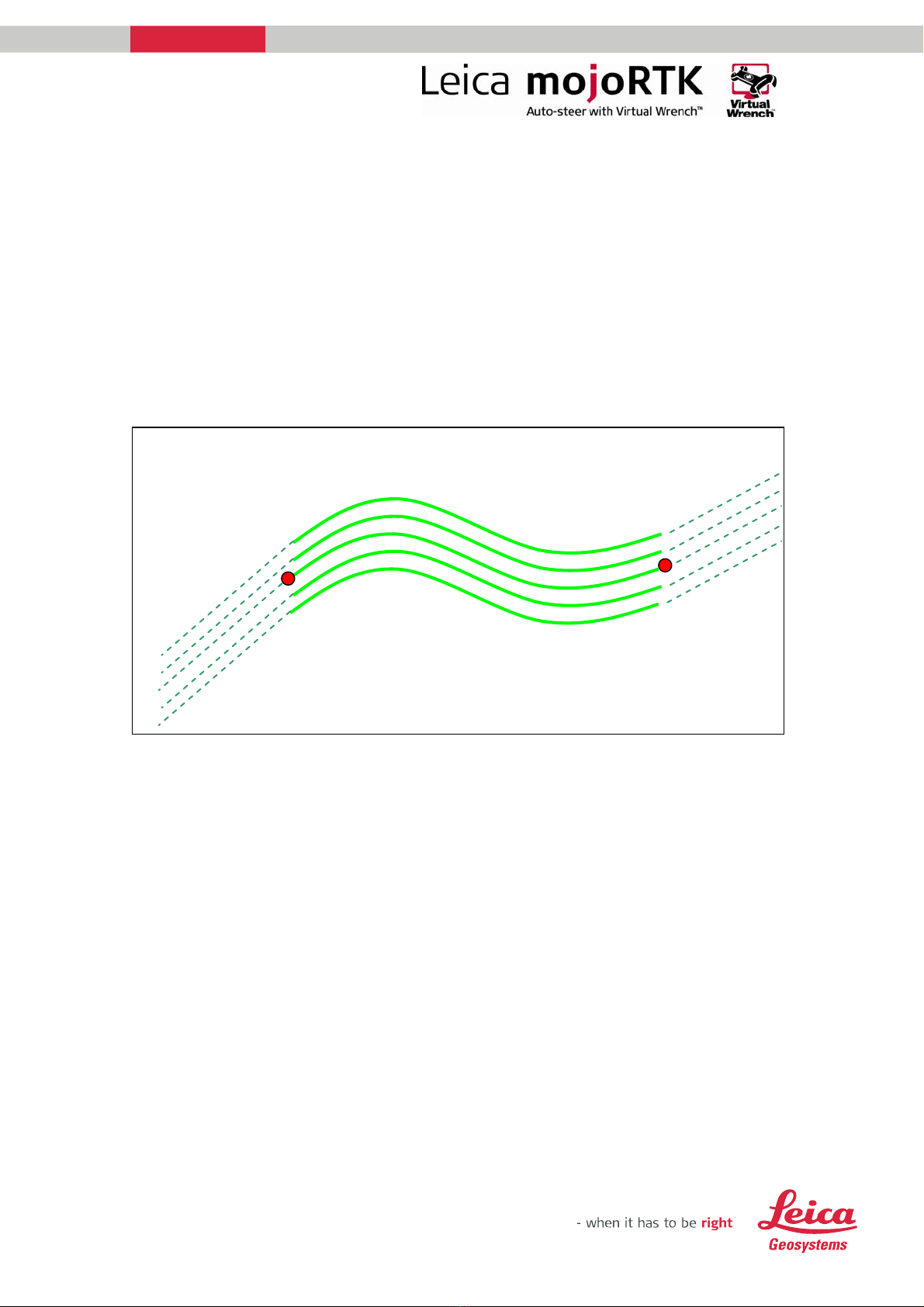
3. contour waylines are not adaptive – gentle curves are best
4. ends of contour waylines are infinitely long straight lines
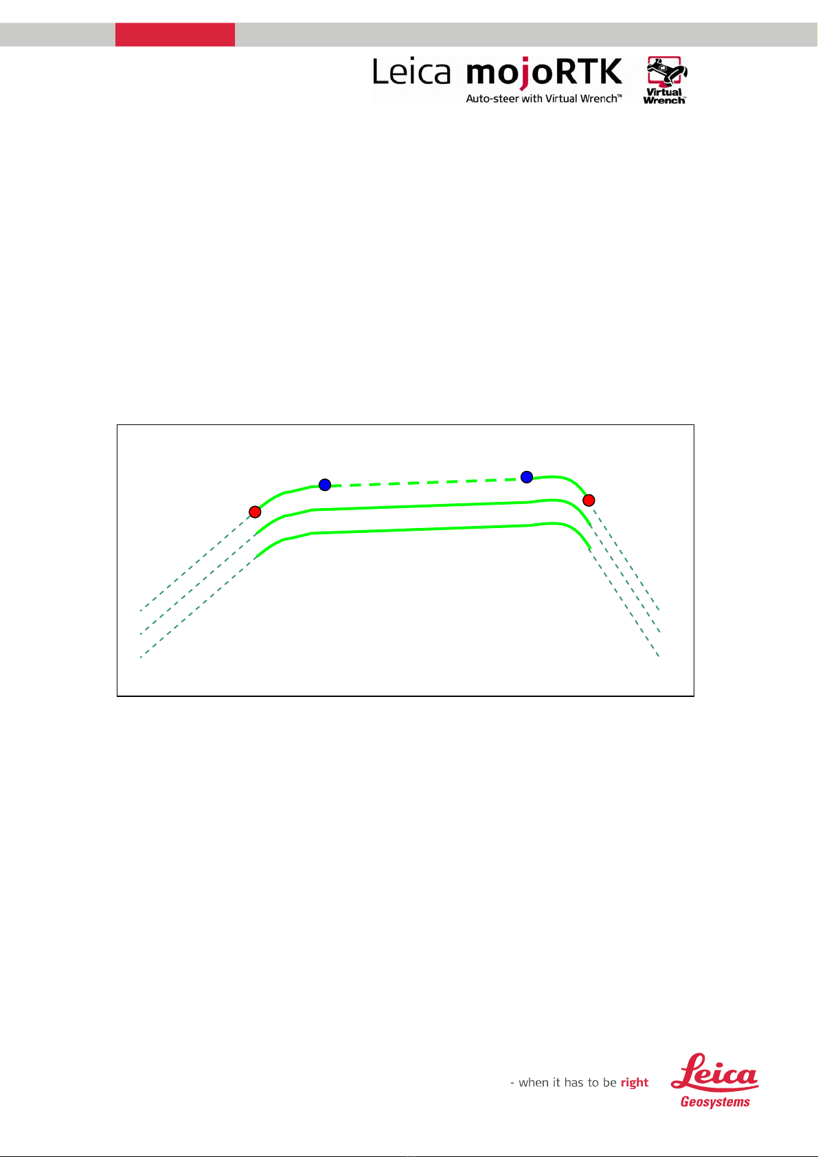
5. Press pause to halt recording for very long straight sections
6. Press play to recommence recording
7. Press OK to store point B
8. See Store wayline - below
Store the current wayline
1. Navigate to the wayline wizard by escaping to the Navigation screen and
pressing SoftKey 1 twice.
2. Press Softkey 3 to bring up ‘store wayline’.
Store wayline
1. You will be asked whether you want to store the wayline for later recall,
select Yes or No
2. Once you have chosen to save the wayline you will have the option to
select which slot (1 through 100) to save the wayline to.
3. Use the main dial to select a slot. Free slots are clearly indicated.
4. Once you have selected a slot press the OK button to save it. You can
select a free slot or a used slot. If you select a used slot the current
details for that slot will be overwritten. If you select No then you will
not be able to recall your wayline unless you subsequently save the
current wayline position.
Recalling a wayline
1. Switch on the mojoRTK console and wait for a good position fix to be
achieved (red light will turn on).
2. If you are not on the navigation screen then press the Esc button until it
comes up.
3. Press Softkey 1 twice to enter the Wayline wizard.
4. Press Softkey 2 once to enter the Recall Wayline screen. Note: A wayline
cannot be recalled if auto-steer is currently engaged. You must
disengage first.
5. If there are waylines stored for your current base position you will have
the option to select which wayline to use.
6. Use the main dial to scroll through the waylines. The current wayline is
indicated with ‘*’. The type of wayline and distance to the A point will
be displayed. Press OK once you have selected the wayline to recall.
7. If your current wayline has not been saved you will be given the option
to save it.
8. After recalling the wayline a mojo operation will be required if the base
is not in exactly the same place for the associated base position.

For more information:
www.mojoRTK.com
Page 9/10 Document #1022 rev1.8
Backing up stored waylines
1. Switch on the mojoRTK console and insert a USB stick (the USB stick
should be cleared of all files and folders prior to its use).
2. Navigate to the main menu. To do this press Esc until you return to the
navigation screen. Then press the OK button.
3. Use the main dial to scroll down to Settings then press the OK button.
4. Use the mail dial to select guidance then press the OK button.
5. Use the main dial to scroll down to Backup Waylines and press the OK
button.
6. A message will then be displayed indicating if the backup was
successful.
7. Once the waylines have been backed up shutdown the console.
8. DO NOT remove the USB stick until the console has fully shutdown
(screen has turned off).
Loading backed up waylines
1. Switch on the mojoRTK console and insert the USB stick containing the
backed up waylines.
2. Navigate to the main menu by pressing Esc until you return to the
navigation screen. Then press the OK button.
3. Use the main dial to scroll down to Settings then press the OK button.
4. Use the mail dial to select guidance then press the OK button.
5. Use the main dial to scroll down to Load Waylines and press the OK
button.
6. You will be prompted to confirm that you wish to load the waylines.
Loading a new set of waylines will ERASE ALL CURRENT WAYLINES.
7. If you wish to cancel then press the Esc button. If you wish to proceed
with loading the waylines then select the Yes button by using the main
dial then press the OK button.
8. A message will then be displayed indicating if the load was successful.
Press the OK button to close the message.
9. The loaded waylines may now be used.
Notes:
Consider labelling your USB sticks when you Backup Waylines. You
might want to use a unique heading from the saved waylines to identify
the USB stick.
The base station location is stored with Waylines when they are
created. The base positions can be imported onto the base station
using a USB stick and the Base Station option Import Waylines.
The wayline file is saved to the USB stick as WaylineDb.xml.

For more information:
www.mojoRTK.com
Page 10/10 Document #1022 rev1.8
Wayline Screen Map - mojoRTK
Table of contents
Other Leica Car Navigation System manuals