BI automotive GC444600 User manual


-1- -2-
Warning
Users shall comply with the information provided in case of any
threat to personal safety.
Caution
Users shall comply with the information provided in case of any
damage to this device.
Tips
Additional information provided for user`s reference.
Illustration
Caution
Tips
Warning
1.Notice
In order to prevent users or others from injury or property loss, please read and follow
the cautions in below:
1. Read instruction
2. Keep the instruction properly for later reference
3. Obey all operation instructions
4. Accessories
Don't use the accessories from another manufacturer, otherwise it may cause accidents.
5. Power
Please use the stated power. You must cut off the power and pull off the power plug in
rainy days or when you won't use it for a long time.
6. Protect power cord
Make sure the power cord is out of feet touch.
7. Installation and wiring
In order to ensure safety, please consign professionals to carry out the installation and
wiring.
8. Maintenance and parts change
Please consign professional technician to maintain and change.
9. Keep away from heat source
Please don't expose the device in sunshine or high temperature. Keep it away from heat,
such as heating machine, heater or any other heating objects.
10. Keep away from water or damp place
Please don't expose this device in rainy or damp conditions.
11. Cleanness
Please wipe the device with dry and soft cloth after power-off, the volatile chemicals,
such as gas or diluting agent.
12. Please cut off power and contact with technician immediately in the following
conditions:
1.2 Safety Information .
Global Positioning System is launched and maintained by USA. This system can
receive the satellite signals from Global Orientation System. Using these signals and
vehicle inductor, the system can indicate current location and help you find required
destinations.
This navigation system can select an economical route, which isn't always the shortest
routes or jam-free. Generally speaking, the driver can reach the required destination
faster with his local knowledge or shortcut rather than this system.
This navigation system can provide visual map and voice instruction. When you are at
the crossing or near the turnoff, the device will remind you of the driving distance and
direction.
1.1 Information Instruction .
using the system.
2. As the system will distract the drivers' attention, in order to keep safety and prevent
from accidents, drivers shall not operate the system while driving.
3. Shall not only depend on the voice navigation which is only for reference. Because
the roads circs, traffic signs and service information aren't always latest, drivers should
update maps timely.
4. There are shortages of system data, for example, roads circs may change frequently;
therefore, you must notice traffic circs before following the system information.
5. This navigation system is only used for assisting drivers to make a judgment, and
may not measure any direction, distance, place, or landform precisely.
1.3 Safety Caution .
The navigation system adopts the most advanced satellite navigation technology and
detailed street map so it can direct you to the destination easily. In order to let you
obtain the best capabilities of the new system, please read the instruction before
operating.

-3- -4-
Time for charging: 3~3.5hrs under standby mode, the time will be different in different
surroundings, the unit can also be charged when power on, but the time shall be longer,
it is normal that the unit heat while charging.
7. What advantages of your GPS solution have?
.
8. Normally, how many satellites can GPS receiver capture?
Normally, most GPS receivers can capture 8-12 satellites.
9. Will the music be distorted if the volume is too high? Sometimes WMA files
can not be played, why?
Please make sure whether the music is obtained legally? If not it must be of big noise.
WMA files has copyright protecting, it needs to be decoded by decoding software during
operation.
10. How to avoid device crashing at the moment of car starting up?
It supports quick global positioning, stable signals, free of service, detailed map for
each city, voice navigation for the whole journey, intelligent lay out the route, operation
system of Microsoft windows CE.net, 3.5 inch TFT touch screen with 65k colors internal
GPS and high capacity rechargeable LI-polymer battery
Users must note that do not connect the GPS with the linker until the car is started up.
1. Whether the positioning and use of GPS can be affected by the weather or
anything else?
Yes, lightning, climate (overcast, rainy and cloudy) etc., all may affect the signals and
use of GPS.
2. What factors may affect the signals of GPS?
1).SA satellite message is from DOD in USA. The precision of GPS signal is directly
controlled by DOD in USA, in order to ensure security, the signal precision for civilian
use is lower than that for army, so in some sensitive places, military base for example,
the signals can be interfered and the precision of positioning may be reduced.
2).Weather factors (macula, bad weather may reduce the intensity of signals and result
in instable orientation.)
3). Electric, electromagnetism, wireless wave and strong magnetic field all has different
certain interference.
4).Under veils, such as buildings, cars, heat insulation papers, metal veils and trees,
they all may reduce the signals of GPS, therefore, place the device close to the
windshield.
3. Why does not GPS receive signals in buildings?
The signals can be obstructed easily by buildings and metals, and they can't penetrate
through the wall of buildings, so the GPS can't be used in buildings.
4. Does the sun membrane affect the signals of GPS?
It will have certain effect on GPS when the material of sun membrane contains metal.
5. How long does the GPS take to position after power on?
About 1 minute the GPS begins to positioning if it is located in wide and non-
interference places, less than or equal to 5 minutes is in accordance with the standard
of GB/T 19392-2003-5.3.
6. What is the maximum navigation time? How long does it take to charge up?
Maximum navigation time: 3~4hrs with volume and brightness at 50%.
Liquid or particle enters into the device;
The device is damaged due to falling off from a high place or incorrect operation;
13. LCD
Prevent LCD from being crashed or fallen, don't touch the liquid flowing out of the
device; don't heat LCD or scratch it.
1.4 Special Tips .
-5- -6-
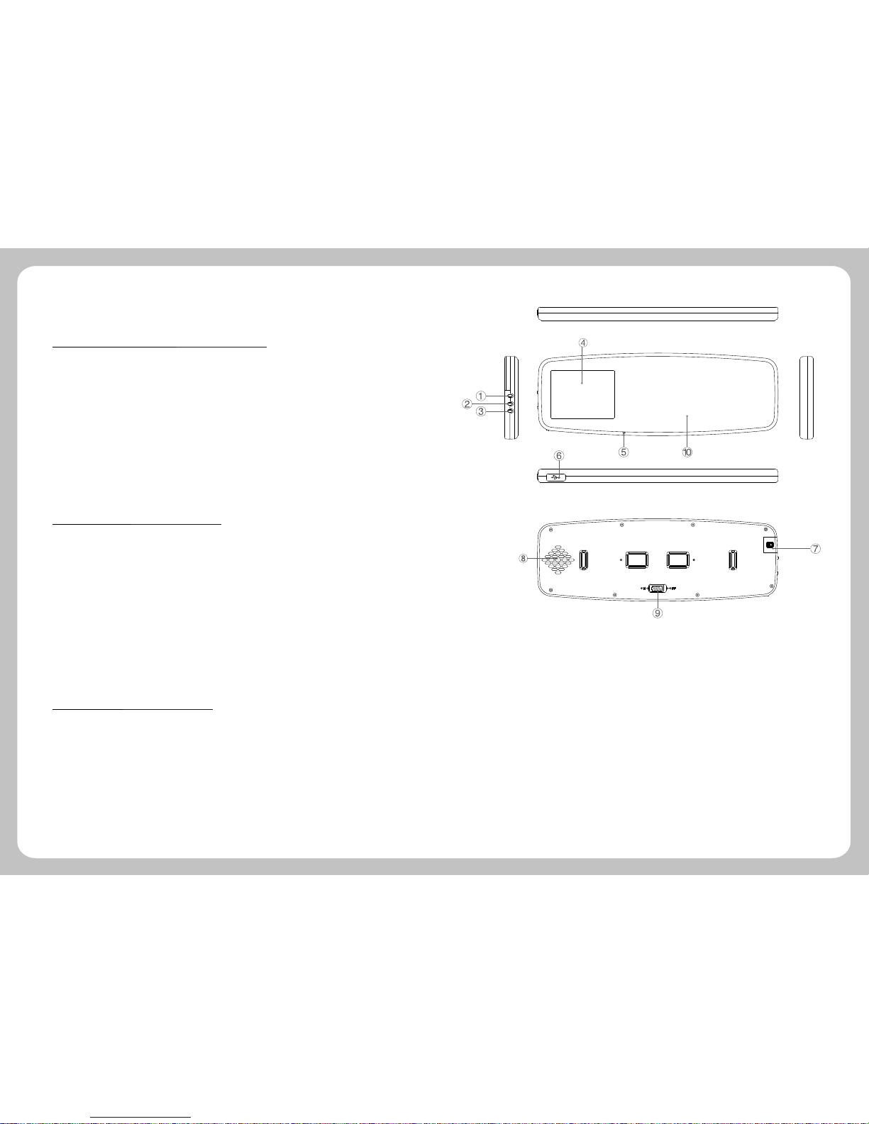
2.Brief Introduction
2.1 Function Introduction .
2.2 Accessories .
2.3 Illustration .
1.Hot key, power indicator (Power supply controlled by vibration sensors)
2.Reset
3.Display on/off key, indicator (when Bluetooth working)
4.Display screen
5.Microphone
6.Mini USB hole
7.Micro SD card slot
8.Speaker
9.Battery switch
10.Mirror
>GPS
>Bluetooth
>TMC
>AV IN
>Support Micro SD card
Navigation
Before using, please make sure whether the device and accessories are complete, if
there is any lack or damage please contact with the local dealer or agent as soon as
possible.
>PND 1pcs
>USB Cable 1pcs
>Car mount 1pcs
>User Manual 1pcs

-7- -8-
3.Basic Operation
3.1 Battery and Charger .
Caution
Caution Please backup the data before resetting the system.
2 Car Mount
The car mount consists of salver and bracket. While using the device in car the device
should be fixed in the proper position of fore-windshield.
3 Micro SD Memory Card
Correctly insert SD/SDHC/MMC card into the slot, and do not remove the
SD/SDHC/MMC card during operation.
1 Reset Key
When the system halted or in the following cases, press reset key to reboot the system:
1. There are delay and stagnation during switch interface;
2. There is no response when click the icons.
3. Power key is unavailable.
3.2 Basic Use .
1 Power Supply
In-vehicle/portable GPS navigation has two ways of power supply: battery supply and
power supply.
When the device doesn't connect with the adaptor, it is supplied by the lithium battery.
The icon at the top right corner on the main interface of system indicates the
current remaining power.
When the device connects with the adaptor, it is supplied by the outer power.
3.3 Connection with Computer .
Connect the device with computer by the USB cable. One end connects with PC and
the other end connects with the device.
Tips
Tips Under normal condition(volume and backlight at 50 ), it
can last about some hours after the battery is fully charged. Some
functions need to consume a lot of battery energy, such as
audio/Movie playing, high backlight and Bluetooth, which may
1. Data transmission: There are two new "mobile disk" icons in my computer after
the device is successfully connected with computer, the first icon stands for the built-in
flash memory of the device, the second stands for the SD card storage of the device. (If
the SD card is not inserted, the second icon of the disk is unavailable). Then, you can
use them as normal USB flash disk.
4.Hot key
Screen rotate 180 degree.
Enter to screen saver, click to screen and
then return to window.
Enter to setting interface.
Enter to Bluetooth setting.
Change from internal speaker to external
speaker.
Caution
Caution 1. Please do not delete and revise the data in the built-in
flash memory of the device, in case some functions of the device are
out of work. 2. Based on Windows 98 operation system, please install
the driver before operating the device. The operation of communication
between GPS and computer are exampled based on the Windows 98
operation system or above version. 3.When GPS is connecting with
computer by USB line, it can not operate the current functions.
2.Safely Remove: Please remove the USB line after finishing the data transmission (just
operate it as the USB flash disk).

-9- -10-
The device supports navigation and Bluetooth for
hands-free and system setting functions. The main
interface is as follows:
5.Function operation
5.1 Navigation .
The Features of Navigation
The device adopts intelligent navigation system, which uses GPS satellite signal receiver
to positioning the mobile vehicle precisely and displayed the mobile vehicle's location on
the E-map. The system will automatically calculate the best route when users set the
destination, it will help the users reach their destinations safely and quickly.
The system also can provide the functions of visual maps, instant cartoon, voice and
instruction and so on.
5.2 .Bluetooth
Press Bluetooth to enter the menu of Bluetooth.""
Tips
Tips when the icon at the left corner of interface
shows red, it means the Bluetooth is not connected, if it shows
green, it means the Bluetooth has been connected.
Click the icon to enter into the equipment pair interface.
Before using Bluetooth, it should be matched. Click the icon to enter into the pair waiting interface,
and then use mobile phone to search for Bluetooth equipment, after finding out the Bluetooth
equipment, input a pair password in mobile phone, the password can be found in the pair password
setting interface. If connect successfully, Pair Success will appear on the screen, or the interface
will go back to main interface after 60 seconds.
Return Return to previous menu
Displaying area for searching time
Tips
Tips
1. Bluetooth of mobile phone should be opened at the same time.
2 Dial Function
Click the icon to open the dial key.
Return :Return to Bluetooth interface
+ : Volume
- : Volume
Dial key: Click it before calling
Hung-up key: Click it after calling
Back space key: Delete the last
number of inputted phone code
Number keyboard: Input number
Number display area: The current called number
3 Call record
Click the icon "Call Record" to open call log.
into dialing key
Record of calls
Return to previous menu
Check dialed numbers
Check received calls
Check missed calls
Check previous record
Check next record
Dial the chose number or switch
Delete the chose records
Delete all records
1 Bluetooth pair
-11-
Click the Dial-last icon, it will switch into the last dialed call automatically. After
entering into this interface, please operate other function according to 5.2.2
""
Click icon to enter into the interface of password setting." Attribute "
Return to previous menu
Show the name of current Bluetooth equipment
Show the password of Bluetooth equipment
Revise password
mean the Bluetooth is still working after
exiting the Bluetooth interface
mean answer the call automatically
Click to enter into the password setting interface.
Return to previous
Esc
Clear
Display area of matching password
Number keyboard
Click icon to enter Bluetooth connection record.
Return to previous menu
Select the previous pair
Select next pair
Delete all records
Disconnect Bluetooth device
Connect with the selected Bluetooth device
Displaying area for connecting Bluetooth device
6 Bluetooth connection
-12-
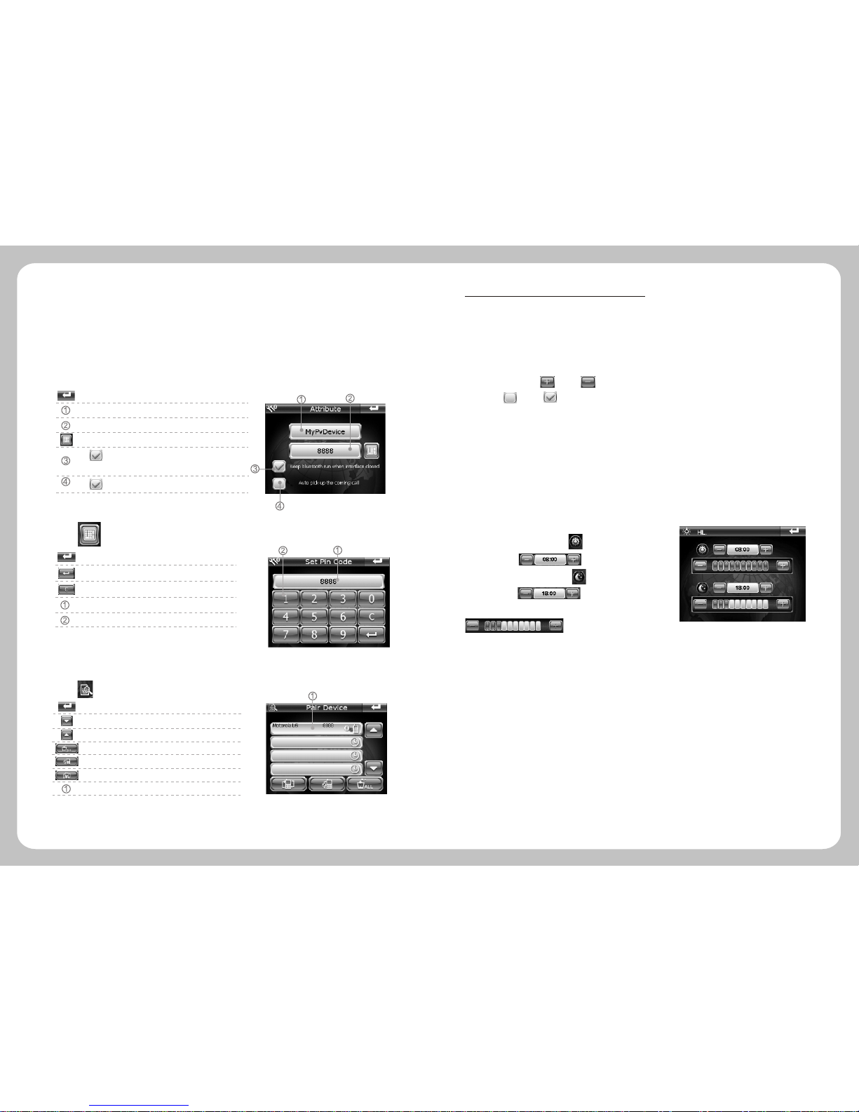
Click "Setting" icon on the main interface to set your system, including volume,
power, Backlight, Date time, language, system information.
3 Backlight Setting
Click "Backlight"to enter backlight setting interface.
Users can click and on the screen to adjust the volume, by
clicking and on the screen which is in front of "Enable sounds for
taps" to decide whether the screen makes a sound or not.
2 Power
Click "power" icon to enter the battery level interface.
Day time ba cklight setting , set day tim e star ted
at XX:XX by
Night time backlight setting , set night time started
at XX:XX by
user can adjust the backlight by
4 Date Time Setting
5 Language setting
Click Language icon to set the language you need.""
Click "Date Time" to enter date time setting interface. Status bar will show
the current separately time, date and time zone.
Separately click "Time", "Date", "Zone" to set up the time, date and time zone.
Through the GPS signals, the time setting refreshes the current time automatically, it
means that the time will temporarily return to the factory setting time after the system
reset. As soon as the GPS begins to navigate, the time will renew to the standard time.
Please note that the time setting should be compatible with the local time.
5.3 System Setting .
1 Adjust the volume
Click the "Volume" icon to enter the related interface
4 Dial-last
5 Bluetooth password
The end user can press the sun or moon touch icon to set the morning and night model
priority.

-13- -14-
Click Sys Info. icon to view the detailed system information.
1. Click Calibration icon at the left corner of information box to adjust the touch
screen. Repeat
click the middle of cursor until the calibration is successful.
""
Choose to move the cursor through middle, left, right, up,down steps.
Signal-to-Noise data Channel
Latitude Altitude
Speed Positioning time
Tips
When you enter this interface to search for GPS singal, if you find
the searching speed is slow or you can not get singnal after a long
time, please click on the "GPS Reset" key to refresh GPS singal.
6 System Information
Longitude
Satellite No
2. Click "Factory Reset"icon at the right corner of
information box, the system will automatically return to
the factory setting.
3. Click "GPS Reset" icon in the middle of information
box, the system will automatically clear up the Signal-
to-Noise data received.
6.Malfunction Analysis
Problem Reason Method
Can not power on Low power
Charge the battery
Power off suddenly Low power
Touch screen deflected
No sound when playing
Tool low volume Turn on the volume
Can`t connect with PC
Poor connection of the USB cable
Refer to the 2.3 chapter, connect the USB cable well.
Calibration is not precise. Refer to 4.6.6 to calibrate your touch screen.
Can not receive
GPS signal
Depending on the intensity of the local signals. It will take about 1 minute to
receive the signal.
Map data missing
Copy the map data into the SD card again.
Contact with local retailer or distributor.
You need to enter the activated password when you use the device again.
Can not charge
Power cable is not
connect well
Please check cable, make sure the polarity is right
Touch screen and
display abnormal
The system crashes Press the reset key
Charge the battery
If the device does not work smoothly, please inspect it according to the following method. If problems
still exist, please connect our Service Centre timely.

-15-
Display
Precision
USB
-10 ~55
Map Update the map data in SD card
Version update
Refreshing rate
Hot start: 3 sec, average
Warm start: 38 sec, average
Cold start: 45 sec, average
Position: < 10 meters
Start-up time
-161dBm
Sensitivity
64 channels
Channels
1575.42MHz
Frequency
GPS Module
320*240 (RGB), 65K colors
Specification
3.5 TFT in rearview mirror, capacitive screen
Pixel
2.5~3.5 hours with 50% volume and backlight.
3.7V /1600mAH
Navigation time
Battery
The power supply controlled by the vibration
sensors. The power cable should be connected
with car battery, Voltage:input DC 12V--24V
Car power supply
Power supply
Languages
External Memory MAX 8G Micro SD
NAND Flash
DDR
Windows CE6.0
CPU Frequency
OS
System
Net Weight
Dimension
7.Technical Specification
1/second
TMC External TMC function Optional
Bluetooth
270*93*15mm
About 340g
Built-in bluetooth
Bluetooth V2.0, handfree mobile phone+vanish echo
SiRFAtlas IV, CPU 500MHz RAM11; DSP 250MHz.
Movie format
Input impedance
Input voltage
Audio format
AVIN
CVBS(PAL&NTSC)
75
1.5Vpp
Analog Signal
English, Italian, French, Spanish, German,
Portuguese, Dutch, Russian, Polish, Hungarian,
Serbian, Romanian. More languages can be
added, as request)
Multi-languages
128MB DDR 16-bit data@266MHz
SLC:64MB-512MB MLC:1GB-4GB
USB 2.0 high speed
Picture rotation 180 (b y software), screen is
on left side default
Picture
Temperature
Operation Temperature
Storage Temperature
-20 ~70 Short-term storage -25 ~75 ,
Port COM7
Table of contents
Popular Automobile Accessories manuals by other brands

Warrior Products
Warrior Products 1555 installation instructions

Aries
Aries 2074106 installation manual

Cequent Performance Products
Cequent Performance Products 24936 installation instructions

Kuat
Kuat SWITCH 4 user guide

AMP Research
AMP Research Power Step installation guide

R.D.GARAGE
R.D.GARAGE RD003 user manual


