Digital Control TERATRAK R1 User manual
TERATRAK R
USER MANUAL
DCI DigiGuide 04.03.2023
DIGITAL CONTROL, INC
19625
nd Ave S Suite B
Kent, WA 98032 U.S.
dci@digital-control.com | digital - control.com
1.800.288.3610 | 1.425.251.0559
TERATRAK R
DCI DigiGuide User Manual
04.03.2023
Important Safety Info
Bootcamp
Initial Setup
Jobsite Setup
Collect Data
Use Terrain Data
Advanced Topics
TERATRAK R
USER MANUAL
DCI DigiGuide 04.03.2023
DIGITAL CONTROL, INC 2
Important Safety Info
GENERAL SAFETY WARNINGS
All operators must read and understand this operator
’
s guide before using
their TeraTrak. Should the equipment be used in a manner not speci
fi
ed in
the operator
’
s guide, the protection provided by the equipment may be
impaired.
Failure to properly care for and maintain your TeraTrak may result in
malfunction or inoperability of the unit. If your TeraTrak malfunctions or
ceases to operate for any reason, stop usage immediately and contact DCI
Customer Service.
The precision of TeraTrak R
data depends on maintaining as much contact
between the crown of R
's tires and the ground surface as possible at all
times during operation. Losing ground contact for even a moment can
reduce the accuracy of R
measurements. Ensure wheels are free of debris.
Walking speed and bumpiness of the surface can reduce wheel contact with
the ground.
Follow the Dynamic Speed Gauge carefully and minimize "red zone"
readings while using R
. Don't use R
on snow or sand and walk particularly
slowly over cobble. Also take care to proceed slowly over curbs. Keep R
upright while operating, do not tilt to a side.
Since R
is designed to produce precision measurements, it is critical that all
inputs be as precise as possible. Inaccurate input data will impact the
accuracy of R
output.
The foregoing factors, failure to carefully follow the operating instructions,
as well as other factors may reduce the accuracy of R
data. Imprecise R
data can lead to inaccurate positioning of the drill rig and inaccuracies in
your bore planning.
TERATRAK R
USER MANUAL
DCI DigiGuide 04.03.2023
DIGITAL CONTROL, INC 3
Inaccuracies in your bore planning can lead to striking underground utilities,
inaccurate installations and/or lost time. You must continue following
customary safety protocols at the jobsite, including identifying buried
utilities and maintaining a customary safety bu
ff
er.
Do not rely solely on R
data. DCI strongly recommends matching up DCI
locating system measurements against R
data points to ensure alignment.
ENVIRONMENTAL REQUIREMENTS
System working elevation:
up to 6500 ft (1981.2 m)
Operating temperatures:
Run mode:
-
°F to 140° F (-
°C to
°C)
Charge mode:
°F to
°F (
°C to
°C)
Storage and transportation:
-
°F to
°F (-
°C to
°C)
Relative Humidity:
<90%
Dust and Water Ingress:
IP
per IEC 60529
Handling Drop (1 meter):
IEC 61010
Vibration:
MIL-STD-
G
Electrostatic Discharge:
IEC 61000-4-2
Operation may be compromised if the equipment is subjected to conditions
outside these speci
fi
ed limits.
Ship in original carrying case or packaging of su
ffi
cient durability to prevent
mechanical shock to equipment during transportation.
If you have any questions about the operation of your TeraTrak R
App or R
,
please contact DCI Customer Service for assistance.
Disposal

TERATRAK R
USER MANUAL
DCI DigiGuide 04.03.2023
DIGITAL CONTROL, INC 4
This equipment must
adhere to the WEEE Recast
Directive (
/
/EU) and
cannot be disposed of with
household waste. For more
information about how to
properly dispose of this
equipment, contact our
customer service
department.

TERATRAK R
USER MANUAL
DCI DigiGuide 04.03.2023
DIGITAL CONTROL, INC 5
Bootcamp
WHAT IS A TERATRAK R
The TeraTrak R
lets you gather data about the terrain and elevation
changes of your job site in real-time. The R
connects via Bluetooth to the
TeraTrak R
App installed on your mobile device.
In the App, you can mark utilities and de
fi
ne reference points, called
waypoints, while walking the bore path. TeraTrak also generates maps,
charts, and rod-by-rod bore plans.
The collected terrain data and job site data can be used for bore planning in
the application of your choice.
HOW THE R
GATHERS TERRAIN DATA
The R
uses multi-axis sensors to measure the angle between the two
wheels. These sensors are a key reason the R
is able to chart terrain
precisely. As it travels over the terrain it continually collects angle and
distance data which the algorithms turn into elevation data.
As you work with longer paths (greater than 100 ft), small errors in the
elevation measurements can accumulate. By following the same path back
to the original starting point, many of the accumulated errors can be
averaged out by the compensation algorithm.
However, a drawback with the multi-axis sensors is that with precision it is
also more sensitive to fast movements. When a user goes over bumpy
terrain the user introduces fast movements (shock) that are di
ffi
cult to
fi
lter
out. Following the will ensure the most accurate data
collection.
speed gauge*

TERATRAK R
USER MANUAL
DCI DigiGuide 04.03.2023
DIGITAL CONTROL, INC 6
The terrain and distance data are referenced from starting point (or the
entry point if it has been moved), which is set initially as distance=
and
elevation=
. For example,
distance= 43 ft and elevation=
ft 9 in, the point being measured is that
distance and elevation from the starting point.
GLOSSARY DEFINITIONS
*DYNAMIC SPEED GAUGE
TeraTrak R
speed gauge displays while the R
is gathering data and provides
feedback on optimum speed for data gathering. The indicator must be in the green
zone for the most accurate data.
PARTS OF THE TERATRAK R
1. Mobile device holder
2. Handle adjustment
3. Battery strength and Bluetooth indicator
TERATRAK R
USER MANUAL
DCI DigiGuide 04.03.2023
DIGITAL CONTROL, INC 7
4. Charging plug outlet
5. Kickstand
6. Reference point
COLLECTING THE BEST DATA
Keep a steady pace with both wheels on the ground, rotating smoothly
and without bouncing. You may need to go slower than the
suggests to ensure accurate readings over bumpy ground. If
measurements are taken while the gauge is in the red area, data may be
suspect.
Mark the ground where you start gathering data and at every mark
made in the TeraTrak R
App. The is the center point
between the wheels where the handle is attached.
To ensure accuracy of the data, always walk the return path as closely
as possible to the original. The return path is shown in orange and then
changes back to green after the two paths are compared and
determined to be accurate.
If the forward and return path are too dissimilar, the App cannot
combine the two paths. A message will advise you to rewalk the path to
gather additional data.
GLOSSARY DEFINITIONS
*DYNAMIC SPEED GAUGE
TeraTrak R
speed gauge displays while the R
is gathering data and provides
feedback on optimum speed for data gathering. The indicator must be in the green
zone for the most accurate data.
*R
REFERENCE POINT
This is the spot on the R
that is used as a reference for the data gathered by the
R
. It is the center point between the wheels where the handle is attached. See the
"Parts of the TeraTrak R
" in the Bootcamp Chapter for an illustration.
speed
gauge
*
reference point*

TERATRAK R
USER MANUAL
DCI DigiGuide 04.03.2023
DIGITAL CONTROL, INC 8
SCREEN ELEMENTS OVERVIEW
Use the TeraTrak R
App to start, stop, pause, and add markers to charts as
you gather data. After the data is collected, there are additional controls to
measure and evaluate the charts. Some controls are only available when the
App is connected to the R
, or while actively collecting and working with
data.
In this guide, screenshots come from both Android and iOS
devices. Some buttons and screens may appear di
ff
erently than
on your device.
TERATRAK R
APP MENU
These controls appear on the top of the TeraTrak R
App screens.
Back
- Returns to the
previous screen
Export -
Exports charts in
an email as and PDF
fi
les.
Devices
- Paired and
discovered R
s
Delete
- Delete a job
CSV*
TERATRAK R
USER MANUAL
DCI DigiGuide 04.03.2023
DIGITAL CONTROL, INC 9
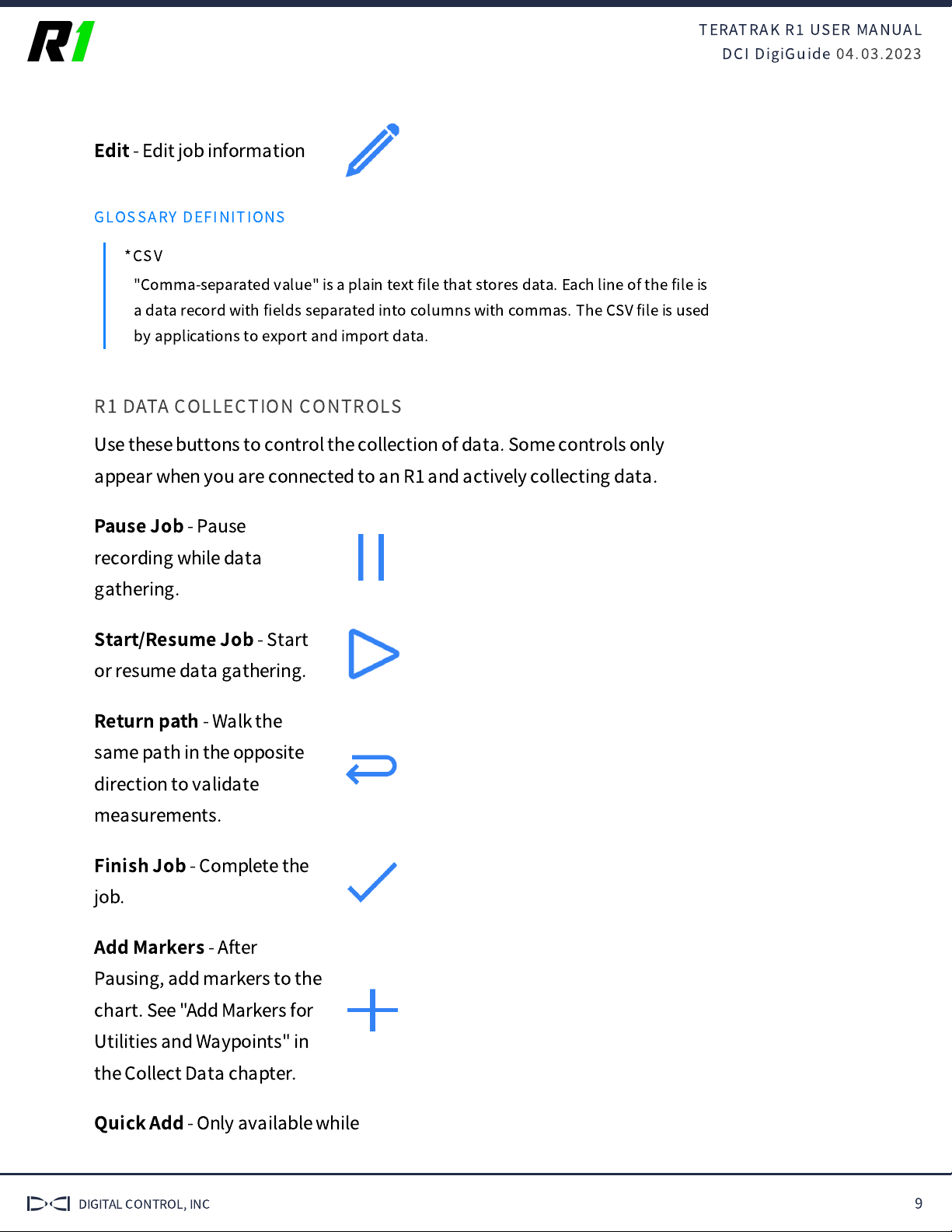
Edit
- Edit job information
GLOSSARY DEFINITIONS
*CSV
"Comma-separated value" is a plain text
fi
le that stores data. Each line of the
fi
le is
a data record with
fi
elds separated into columns with commas. The CSV
fi
le is used
by applications to export and import data.
R1 DATA COLLECTION CONTROLS
Use these buttons to control the collection of data. Some controls only
appear when you are connected to an R
and actively collecting data.
Pause Job
- Pause
recording while data
gathering.
Start/Resume Job
- Start
or resume data gathering.
Return path
- Walk the
same path in the opposite
direction to validate
measurements.
Finish Job
- Complete the
job.
Add Markers
- After
Pausing, add markers to the
chart. See "Add Markers for
Utilities and Waypoints" in
the Collect Data chapter.
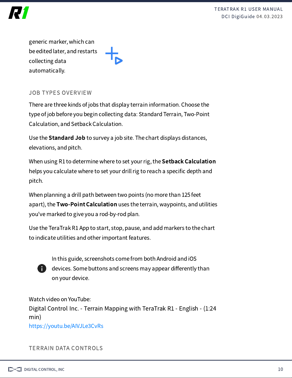
Quick Add
- Only available while
TERATRAK R
USER MANUAL
DCI DigiGuide 04.03.2023
DIGITAL CONTROL, INC 10
generic marker, which can
be edited later, and restarts
collecting data
automatically.
JOB TYPES OVERVIEW
There are three kinds of jobs that display terrain information. Choose the
type of job before you begin collecting data: Standard Terrain, Two-Point
Calculation, and Setback Calculation.
Use the
Standard Job
to survey a job site. The chart displays distances,
elevations, and pitch.
When using R
to determine where to set your rig, the
Setback Calculation
helps you calculate where to set your drill rig to reach a speci
fi
c depth and
pitch.
When planning a drill path between two points (no more than 125 feet
apart), the
Two-Point Calculation
uses the terrain, waypoints, and utilities
you've marked to give you a rod-by-rod plan.
Use the TeraTrak R
App to start, stop, pause, and add markers to the chart
to indicate utilities and other important features.
In this guide, screenshots come from both Android and iOS
devices. Some buttons and screens may appear di
ff
erently than
on your device.
Watch video on YouTube:
Digital Control Inc. - Terrain Mapping with TeraTrak R
- English - (1:24
min)
https://youtu.be/AIVJLe
CvRs
TERRAIN DATA CONTROLS
TERATRAK R
USER MANUAL
DCI DigiGuide 04.03.2023
DIGITAL CONTROL, INC 11
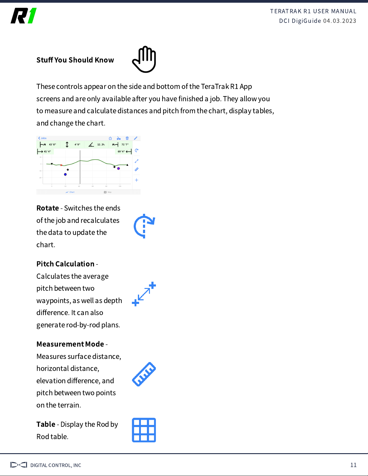
Stu
ff
You Should Know
These controls appear on the side and bottom of the TeraTrak R
App
screens and are only available after you have
fi
nished a job. They allow you
to measure and calculate distances and pitch from the chart, display tables,
and change the chart.
Rotate
- Switches the ends
of the job and recalculates
the data to update the
chart.
Pitch Calculation
-
Calculates the average
pitch between two
waypoints, as well as depth
di
ff
erence. It can also
generate rod-by-rod plans.
Measurement Mode
-
Measures surface distance,
horizontal distance,
elevation di
ff
erence, and
pitch between two points
on the terrain.
Table
- Display the Rod by
Rod table.

TERATRAK R
USER MANUAL
DCI DigiGuide 04.03.2023
DIGITAL CONTROL, INC 12
waypoints, utilities, and
other markers.
Chart
- Toggle between
chart and bird's eye view.
Map
- Toggle between bird's
eye view map and chart.
You can use the pinch and spread controls to zoom in or zoom
out of data, maps, and charts.
ROD-BY-ROD TABLE
The rod-by-rod table is available for Setback and Two-Point Calculation jobs
types. It is also available as a Standard job after entering
Pitch Calc
mode.
After you
fi
nish mapping, tap
Table
.
A rod-by-rod table is generated based on your default settings and your data
collected.
Tap a dot on the bore path to highlight the corresponding row of data.
1. Rod number
2. Rod length or rod remaining
3. Pitch
4. Locator depth
5. Vertical depth
TERATRAK R
USER MANUAL
DCI DigiGuide 04.03.2023
DIGITAL CONTROL, INC 13
6. Terrain topography
7. Entry point (for Setback job) or current starting point
8. Rod and corresponding rod data
9. More information is available on this data point. See "App Messages" in
the Advanced Topics chapter.
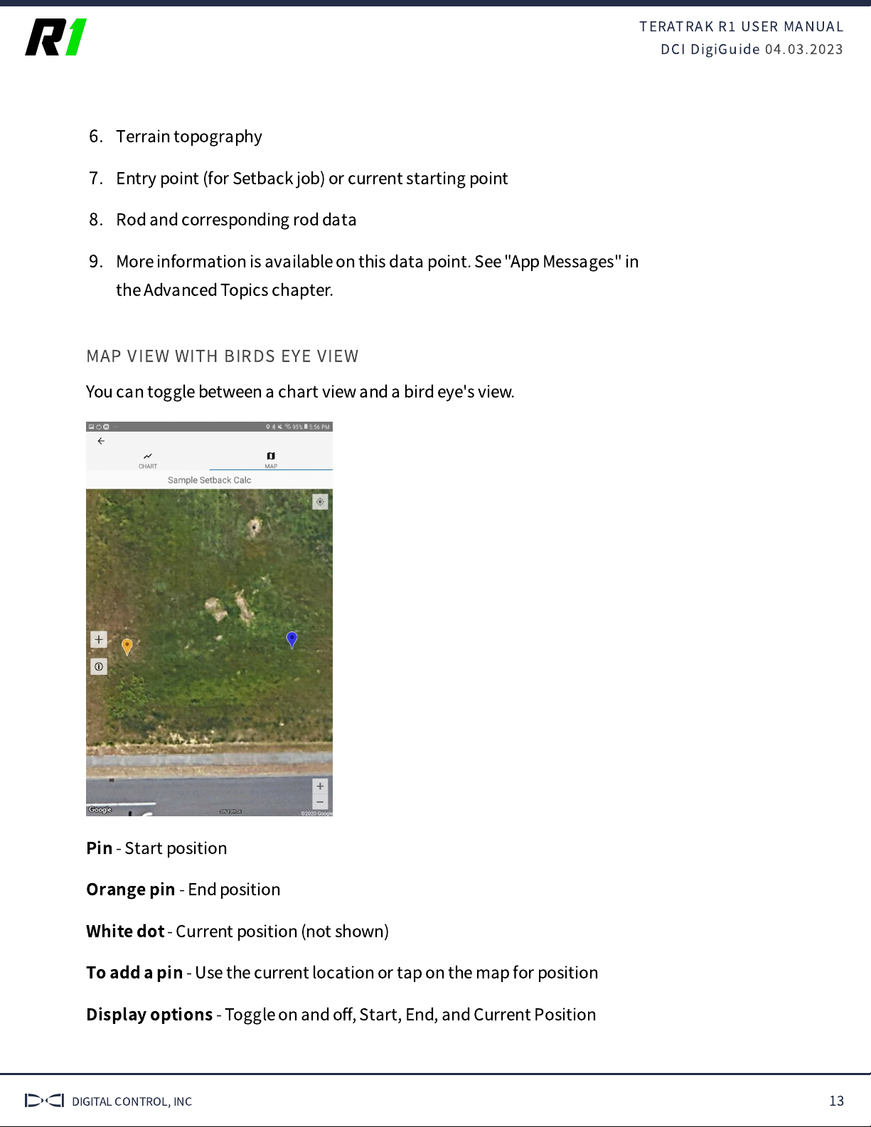
MAP VIEW WITH BIRDS EYE VIEW
You can toggle between a chart view and a bird eye's view.
Pin
- Start position
Orange pin
- End position
White dot
- Current position (not shown)
To add a pin
- Use the current location or tap on the map for position
Display options
- Toggle on and o
ff
, Start, End, and Current Position

TERATRAK R
USER MANUAL
DCI DigiGuide 04.03.2023
DIGITAL CONTROL, INC 14
The App uses the native map software for your device's
operating system, Apple Maps or Google maps. Map markings
may di
ff
er.
TERATRAK R
USER MANUAL
DCI DigiGuide 04.03.2023
DIGITAL CONTROL, INC 15
Initial Setup
ASSEMBLING THE R
STEP 1 OF 3
Insert the handle into the socket until it locks in place.
STEP 2 OF 3
Use the buttons on the bottom to adjust the handle to a comfortable height.
STEP 3 OF 3
Attach the mobile device holder.
CHARGE THE BATTERY
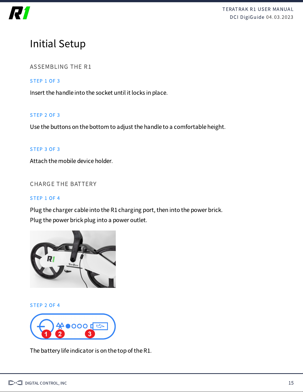
STEP 1 OF 4
Plug the charger cable into the R
charging port, then into the power brick.
Plug the power brick plug into a power outlet.
STEP 2 OF 4
The battery life indicator is on the top of the R
.
TERATRAK R
USER MANUAL
DCI DigiGuide 04.03.2023
DIGITAL CONTROL, INC 16
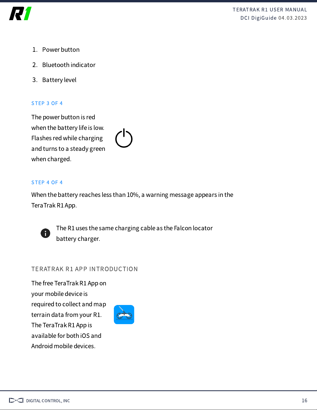
1. Power button
2. Bluetooth indicator
3. Battery level
STEP 3 OF 4
The power button is red
when the battery life is low.
Flashes red while charging
and turns to a steady green
when charged.
STEP 4 OF 4
When the battery reaches less than 10%, a warning message appears in the
TeraTrak R
App.
The R
uses the same charging cable as the Falcon locator
battery charger.
TERATRAK R
APP INTRODUCTION
The free TeraTrak R
App on
your mobile device is
required to collect and map
terrain data from your R
.
The TeraTrak R
App is
available for both iOS and
Android mobile devices.

TERATRAK R
USER MANUAL
DCI DigiGuide 04.03.2023
DIGITAL CONTROL, INC 17
INSTALL TERATRAK R
APP ON MOBILE DEVICES (ANDROID)
STEP 1 OF 5
TeraTrak R
requires the TeraTrak R
App on your mobile device to collect
terrain data. Download and install the free TeraTrak R
App from the App
Store or Google Play Store. The TeraTrak R
app is compatible with Android
5.0 or later.
STEP 2 OF 5
On your mobile device, go to the App Store.
STEP 3 OF 5
Search for "TeraTrak."
STEP 4 OF 5
Tap
Install
.
STEP 5 OF 5
The TeraTrak R
App
shortcut appears on your
Home screen. Tap the icon
to open.
INSTALL TERATRAK R
APP ON MOBILE DEVICES (IOS)
STEP 1 OF 5
TeraTrak R
requires the TeraTrak R
App on your mobile device to collect
terrain data. Download and install the free app from the App Store. The
TeraTrak R
App is compatible with iOS 10.0 or later on iPod touch, iPad, and
iPhone.
TERATRAK R
USER MANUAL
DCI DigiGuide 04.03.2023
DIGITAL CONTROL, INC 18
STEP 2 OF 5
On your mobile device, go to the App Store.
STEP 3 OF 5
Search for "TeraTrak."
STEP 4 OF 5
Tap
Install
.
STEP 5 OF 5
The TeraTrak R
App
shortcut appears on your
Home screen. Tap the icon
to open.
PAIR THE R
TO YOUR MOBILE DEVICE
STEP 1 OF 5
Before You Start
The TeraTrak R
App needs to be installed before you can pair with the R
.
STEP 2 OF 5
Power on the R
. The
Bluetooth icon will
fl
ash
blue.
STEP 3 OF 5

TERATRAK R
USER MANUAL
DCI DigiGuide 04.03.2023
DIGITAL CONTROL, INC 19
In the TeraTrak R
App, tap
R
Information
.
STEP 4 OF 5
In the list of devices, under
Discovered Devices
, tap the name of your R
.
If your device doesn't show up on the list, try these solutions. 1)
Make sure that the R
is on and the Bluetooth is enabled on the
mobile device. 2) The App has access to Bluetooth.
STEP 5 OF 5
The paired device will appear under
Paired Devices
, and the Bluetooth icon
turns a steady blue.

TERATRAK R
USER MANUAL
DCI DigiGuide 04.03.2023
DIGITAL CONTROL, INC 20
SET PITCH UNITS
STEP 1 OF 5
Angle or pitch can be represented as either degrees (°) or percentages (%).
STEP 2 OF 5
Tap
Settings
.
STEP 3 OF 5
Tap
Pitch Units
.
STEP 4 OF 5
Select either X.X% (percentage) or X.X °(degrees).
Other manuals for TERATRAK R1
1
Other Digital Control Industrial Equipment manuals


Popular Industrial Equipment manuals by other brands


Generac Power Systems
Generac Power Systems PV Link 010023 installation manual

ABB
ABB HT603864 Operation manual

Hog Technologies
Hog Technologies STRIPE SH7500 Operation manual

Williams
Williams 8FC38F Operator's manual

Emerson
Emerson AVENTICS AS5-ACC Series RE-ASSEMBLY INSTRUCTIONS

Bisonte
Bisonte BTA-DV8T user manual