EGi Geoscan User manual

GeoScan
Sensor digitization
system
User manual
For Scientific Research Purposes
Electrical Geodesics, Inc.
500 E 4th Avenue, Suite 200
Eugene, OR 97401
USA
www.egi.com

2FOR SCIENTIFIC RESEARCH PURPOSES | 8100550-03 •2018-10-26 | GeoScan User Manual
Copyright © 2018 by Electrical Geodesics, Inc.
All rights reserved.
The information in this document is subject to change without notice. Electrical Geodesics,
Inc. (EGI) makes no warranty or representation, either express or implied, with respect to
this manual, its quality, accuracy, merchantability, or fitness for a particular purpose. In no
event will Electrical Geodesics be liable for direct, indirect, special, incidental, or
consequential damages resulting from any defect or inaccuracy in this manual, even if
advised of the possibility of such damage.
Sold and Distributed Exclusively by:
Electrical Geodesics, Inc. (EGI)
500 E 4th Avenue, Suite 200, Eugene, OR 97401, USA
+1.541.687.7962 (tel) • +1.541.687.7963 (fax)
GeoScan is not intended for use in diagnosis or treatment of any disease or condition. It is
a scientific research instrument designed for performing measurements and acquiring
data for neurophysiological research. Philips makes no representation of the suitability of
the instrument for any particular research study.

GeoScan User Manual | 8100550-03 •2018-10-26 | FOR SCIENTIFIC RESEARCH PURPOSES 3
GeoScan
Sensor Digitization System
Handheld Scanner and Software
version 1.3
User Manual
For Scientific Research Purposes

4FOR SCIENTIFIC RESEARCH PURPOSES | 8100550-03 •2018-10-26 | GeoScan User Manual
Key changes in this revision:
•Title Page: Changed manufacturer information
•Section 2.2.2: Revised LED indications
•Section 2.3: Updated OS X system requirements
•Section 2.2.3: Updated audible tones section
•Section 2.4.1: Added the Stability Trigger preferences
•Section 3.1: Added restart instruction after installation
•Section 3.2: Added download information for Java
•Section 5.3.1: Clarified scanner orientation
•Section 5.3.4: Updated Stability Trigger information
•Section 6.7: Updated probe instructions
•Section 6.8: Revised for clarity, updated screenshots, and updated probe
instructions
•Updated Warnings and Cautions throughout

GeoScan User Manual | 8100550-03 •2018-10-26 | FOR SCIENTIFIC RESEARCH PURPOSES 5
Contents
Preface 9
1Safety and Use Conditions 17
1.1 Directions for Use 18
1.2 Features 18
1.3 Conditions for Use 19
1.3.1 Environmental Conditions for Transport and Storage 19
1.3.2 Environmental Conditions for Use 19
1.3.1 Optical Radiation of Scanner Illuminators 19
1.3.2 Scan Volume 20
1.3.3 Interference – Radio Frequency Emissions 21
1.3.4 Certifications and Classifications 22
1.3.5 Symbols 22
1.4 Safety Warnings 24
1.4.1 Personal Injury Risks 24
1.4.2 Equipment Damage Risks 25
2GeoScan’s Scanner and Software 26
2.1 Overview and Specifications 26
2.2 GeoScan Handheld Scanner 27
2.2.1 Buttons and Indicators 27
2.2.2 Indications of the Scanner’s LED Stripe 28
2.2.3 Audible Tones 29
2.2.4 Scanner / Computer / Cable Connections 29
2.2.5 Scanning Apertures and Lenses 30
2.2.6 Calibration 31
2.3 GeoScan System Requirements 31
2.4 GeoScan Software Interface 31

6FOR SCIENTIFIC RESEARCH PURPOSES | 8100550-03 •2018-10-26 | GeoScan User Manual
2.4.1 GeoScan Menus 31
2.4.2 GeoScan’s Onscreen Command Buttons 35
2.4.3 GeoScan Window Panes 38
2.4.4 Markers of the 3D Sensor Cloud 40
2.4.4.1 Mouse Controls for the 3D Sensor Cloud 41
2.4.4.2 Mouse Controls for Markers 41
3Installing the GeoScan Software 43
3.1 Installing the GeoScan Software 43
3.2 Installing Java 46
4Cabling the GeoScan Hardware 49
5GeoScan Process 53
5.1 GSN Application 53
5.2 GeoScan Stages 54
5.3 Scanning Tips and Environment 55
5.3.1 How to Hold and Orient the Scanner 55
5.3.2 Scanning Environment 59
5.3.3 Scanning Tips 60
5.3.4 Probing Tips 65
6Using GeoScan 67
6.1 When to Scan 67
6.2 For Best Results 67
6.3 Before Beginning 67
6.4 Launching the Software and Turning on the Scanner 68
6.5
STAGE
1
—
Selecting a Template 70
6.6
STAGE
2
—
Scanning the Sensor Locations
71
6.7
STAGE
3
—
Probing the Fiducial Points 77
6.8
STAGE
4
—
Probing the Alignment Sensors 82
6.9
STAGE
5
—
Labeling and Review 87
6.10
STAGE
6
—
Exporting 3D Coordinate Files
91

GeoScan User Manual | 8100550-03 •2018-10-26 | FOR SCIENTIFIC RESEARCH PURPOSES 7
6.11
STAGE
7
—
Converting the .txt Files 92
6.11.1 Convert using Import / Export 92
6.11.2 Convert using the GeoScan Batch Converter 94
6.12
optional
Photograph Sensor Placement for Source
Localization 97
6.13 Quitting or Storing the System 98
6.14
optional
Capturing Images 99
7
GeoScan
Quick Guide FOR PROFICIENT USERS 101
8Maintenance and Cleaning 103
8.1 Maintenance 103
8.2 Cleaning Surfaces 103
8.2.1 GeoScan Handheld Scanner 104
Appendix A: EMC Declarations 107

8FOR SCIENTIFIC RESEARCH PURPOSES | 8100550-03 •2018-10-26 | GeoScan User Manual

GeoScan User Manual | 8100550-03 •2018-10-26 | FOR SCIENTIFIC RESEARCH PURPOSES 9
Preface
elcome to the GeoScan™ sensor
digitization system from Electrical
Geodesics, Inc. (EGI). The GeoScan
handheld scanner and software are used with
EGI’s Geodesic EEG System™ (GES) 400 series
systems, including EGI’s HydroCel and
MicroCel Geodesic Sensor Net™ (GSN) EEG
sensor arrays, to digitize the location of up to
256 EEG sensors on a subject’s scalp.
The GeoScan handheld scanner captures the locations of sensors and the
GeoScan software outputs a 3D coordinate file of those locations.
The GeoScan system steps you through the stages of its automated
registration process:
Template: Here you select a sensor template that matches the sensor
layout of the GSN being worn by a subject.
The template predicts the locations of the sensors in that GSN, while the
remaining steps verify and/or correct those predictions.
Scan: Here you move the handheld scanner around a subject’s
head to record the physical locations of EEG sensors.
Probe: Here you probe the fiducial skull landmarks to
confirm those locations for the software.
Align: Here you probe a few strategic sensors to align
the 3D sensor cloud with the sensor template.
Label: Here you review the labels in the 3D sensor
cloud and make any changes necessary before exporting the 3D
coordinate file.
W

10 FOR SCIENTIFIC RESEARCH PURPOSES | 8100550-03 •2018-10-26 | GeoScan User Manual
Export: Here you export the sensor locations as a 3D coordinate
file. With these 3D coordinate files, you can:
•create EEG topo maps that are adjusted to an individual’s
head geometry
•register the sensor locations with head models to
improve the accuracy of source localization
•convert the 3D coordinate text files into file formats for
continued work with Net Station, BESA, and MATLAB
Convert:Here you will use the GPS Solver software to convert the
GeoScan 3D coordinate .txt files into one of several formats for
use in Net Station, BESA, MATLAB, etc.
Photograph (optional):Lastly, if you will be creating head
models for use in EGI’s GeoSource software, you will need to
take corroborating photographs of the GSN as applied on the
subject’s head.
GeoScan User Manual | 8100550-03 •2018-10-26 | FOR SCIENTIFIC RESEARCH PURPOSES 11
GeoScan Components
Table P-1. Parts list for a typical GeoScan system
Part Qty Mfr Mfr P/N EGI P/N
NOT ALL SYSTEM OR SOFTWARE FEATURES ARE AVAILABLE FOR PURCHASE OR USE IN ALL
COUNTRIES OR MARKETS. Refer to www.egi.com/company/certificationscompany.
For all safety, use conditions, and step-by-step instructions for using the components of your EGI system, refer to the manuals
and instructions (including third-party manufacturer documentation) that shipped with your system configuration.
Core components—Scanner and Software
GeoScan scanner
FOR SCIENTIFIC
RESEARCH PURPOSES
1 pkg EGI
4609761
GeoScan software
FOR SCIENTIFIC
RESEARCH PURPOSES
Host USB converter
Power supply
Core components—Misc.
Wireless optical probe 1 EGI
6300700
Optional components
iMac computer, monitor, keyboard, mouse
1
Apple
current variant
current variant
Additional handheld scanner 1 EGI
4609760
Documentation
iMac computer, monitor, keyboard, mouse
For all safety and use conditions for using the computer
that is shipped with your EGI system, refer to third-party
manufacturer manuals at
https://support.apple.com/country-selector/manuals.
GeoScan manual
FOR SCIENTIFIC
RESEARCH PURPOSES
1 EGI
8100550

12 FOR SCIENTIFIC RESEARCH PURPOSES | 8100550-03 •2018-10-26 | GeoScan User Manual
Typical GeoScan System
The GeoScan sensor digitization system (handheld scanner and software)
digitizes the locations of up to 256 EEG sensors in a Geodesic Sensor Net
(GSN) on a subject’s head.
Figure P-1. Core components of a typical EEG-only GES system, including the GeoScan system
GeoScan User Manual | 8100550-03 •2018-10-26 | FOR SCIENTIFIC RESEARCH PURPOSES 13
About This Manual
This manual provides information for installing and safely and effectively
using the GeoScan sensor digitization system (handheld scanner and
software). It assumes a working proficiency with EEG and computer
systems.
Typographic conventions:
•Italics are used for definitions or newly introduced terms.
•Boldface italics are used for important concepts or special
emphasis.
•Boldface is used for command paths (for example, File Open).
Warnings, Cautions, and Notes
The following are used to convey important information:
WARNING: Warnings provide important information that, if
unheeded, could result in serious physical injury, death, or
equipment damage.
CAUTION: Cautions provide important information that, if
unheeded, could hinder the use of a product, feature, or procedure,
or result in physical injury or equipment failure.
Note: Notes provide clarifying information about a product, feature, or procedure.

14 FOR SCIENTIFIC RESEARCH PURPOSES | 8100550-03 •2018-10-26 | GeoScan User Manual
Support, Repairs, and Documentation
Electronic copies of EGI’s user manuals and instructions are available
for download at www.egi.com/knowledge-center or from the
Training and Technical Support tab at www.egi.com.
For articles that address the various procedural and theoretical aspects of sensor
localization, click the Training and Technical Support tab at www.egi.com.
•The Type tab provides articles by:
−application advice (usage, best
practices, workflows, etc.)
−technical/troubleshooting/
help advice
−implementation theory of
features and functions
−
theoretical background of dEEG,
sensor localization, source
localization, etc.
•The Products tab provides
articles by product group.
•The Manuals tab provides
product manuals by product
group.
•The Video Tutorials tab
provides product and
instruction videos.
PERFORMANCE AND SUPPORT
Tested. All components of your EGI system have been fully tested at the
factory and certified to meet performance standards prior to shipping.
Training.To optimize your proficiency with your system, onsite training
can be provided by an EGI support or authorized engineer.
Questions.At any time you have questions or wish additional training,
contact Philips Neuro Technical Support (Table P-2).

GeoScan User Manual | 8100550-03 •2018-10-26 | FOR SCIENTIFIC RESEARCH PURPOSES 15
If you have a question, please:
•For urgent issues during acquisition, contact EGI immediately.
•For nonurgent issues, do the following before contacting EGI:
–Isolate the problem.
Try to repeat and define the problem.
–Document the problem.
Carefully record the sequential details of the problem.
–Report the defined problem.
Contact EGI.
Table P-2. EGI contact information
Philips Neuro Technical Support online www.egi.com/knowledge-center
Email Technical Support supportteam@egi.com
Email Sales orderdesk@egi.com
Telephone +1.541.687.7962
Fax +1.541.687.7963
Address Electrical Geodesics, Inc. (EGI)
500 E 4th Avenue, Suite 200
Eugene, OR 97401
USA

16 FOR SCIENTIFIC RESEARCH PURPOSES | 8100550-03 •2018-10-26 | GeoScan User Manual

GeoScan User Manual | 8100550-03 •2018-10-26 | FOR SCIENTIFIC RESEARCH PURPOSES 17
1Safety and Use
Conditions
Before using your EGI system, including its software, ensure that you are
fully trained, proficient in its use, and understand all warnings, cautions,
and conditions for use provided in EGI’s manuals for the components of
your system.
All EGI system components must be connected by a qualified service
technician and configured according to the instructions in this manual.
Deviating from the supported configuration, running the system with non-
EGI-approved components attached, or poorly connected devices may
result in: hazards or unexpected performance due to additional loading or
leakage; or poor system timing and/or poor data quality that may not be
apparent.
For all safety and use conditions for using your EGI system, refer to
the manuals and instructions that shipped with your system.
MR Unsafe. Never bring into the MR environment.
If you have any questions, contact Philips Neuro Technical Support
(Table P-2).
Note that the information in this manual is subject to change, without notice. The
manufacturer declines responsibility for the safety, reliability, and performance of EGI
system components if not used in compliance with EGI documentation.

18 FOR SCIENTIFIC RESEARCH PURPOSES | 8100550-03 •2018-10-26 | GeoScan User Manual
1.1 Directions for Use
As an optional component of the GES 400 family of EEG devices, the
GeoScan sensor digitization system (handheld scanner and software) is
intended to:
•Quickly and accurately record the locations of EEG electrodes in a
Geodesic Sensor Net (GSN) on a subject’s head.
•Provide sensor localization data.
•Be used by a trained technician or researcher.
•Be used with adults, children, and infants.
•Be used with the exception that the accessory Geodesic Sensor Nets
(GSNs) are not recommended for use with non-intact skin.
For scientific research purposes. For indoor use only.
1.2 Features
•Digitizes the location of up to 256 sensors on the scalp
•Scans sensors in 5 to 10 minutes
•Displays progress of sensor registration with a 3D sensor cloud
and counter
•Detects fiducial points and alignment sensors using the provided
probe
•Outputs 3D coordinate files of sensor locations
Useful for head modeling.
•Uses GPS Solver to convert the 3D coordinate files
Available formats are compatible with BESA, EMSE, Curry, and EEG Lab.
•Minimizes human errors with semi-automated system
•Operates with a lightweight and ergonomic handheld scanner
and step-by-step software
•Requires no restraint—not susceptible to movement artifacts

GeoScan User Manual | 8100550-03 •2018-10-26 | FOR SCIENTIFIC RESEARCH PURPOSES 19
1.3 Conditions for Use
1.3.1 Environmental Conditions for Transport and
Storage
Table 1-1. Environmental conditions for the transport and storage of GeoScan components
Storage Temperature -10˚ to 50˚C (15˚ to 125˚F)
Relative humidity 10% to 90% non-condensing
Atmospheric pressure 50 kPa to 106 kPa
1.3.2 Environmental Conditions for Use
For EMC declarations, see Appendix A.
Table 1-2. Environmental conditions for the use of the GeoScan components
Operating temperature 10˚ to 30˚C (50˚ to 90˚F)
Relative operating humidity 30% to 75%
Atmospheric pressure 70 kPa to 106 kPa
1.3.1 Optical Radiation of Scanner Illuminators
Eye safe. The GeoScan illuminators emit invisible LED radiation. These
have been assessed against the standards listed in the Declaration of
Conformity and found not to pose any potential hazard to eyes under
any foreseeable viewing condition.
IR interference. The GeoScan scanner emits IR light that may interfere
with IR controlled devices, such as operating room tables. It is
recommended that you test the GeoScan scanner, if you intend to use
it in an environment where IR controlled devices will be in use.
20 FOR SCIENTIFIC RESEARCH PURPOSES | 8100550-03 •2018-10-26 | GeoScan User Manual
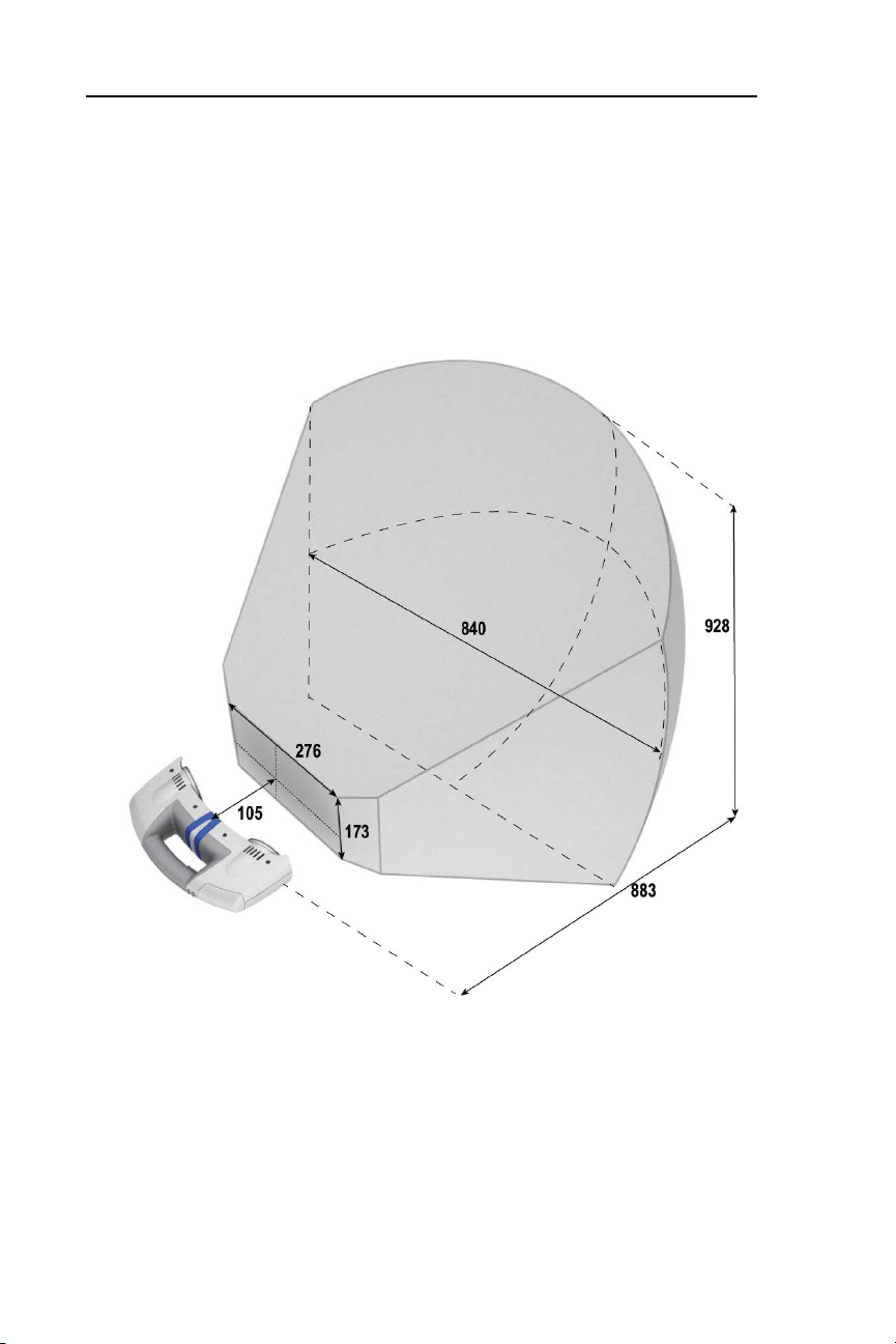
1.3.2 Scan Volume
The scan volume is the area in which the GeoScan handheld scanner can
optimally scan the sensors of a Geodesic Sensor Net (GSN). Ensure that the
GSN being scanned is positioned within this area.
Figure 1-1. Scan volume of the GeoScan handheld scanner (dimensions in millimeters (mm))
105 mm ≈ 4 in.
276 mm ≈ 11 in.
173 mm ≈ 7 in.
840 mm ≈ 33 in.
928 mm ≈ 37 in.
883 mm ≈ 35 in.
Table of contents
Popular Laboratory Equipment manuals by other brands

Thermo Scientific
Thermo Scientific 7450 instruction sheet

Genevac
Genevac EZ-2 Series user manual

Electron Microscopy Sciences
Electron Microscopy Sciences PA 2500 instruction manual

Steril-Aire
Steril-Aire SE Series Installation, operation and maintenance instructions

biodex
biodex ATOMLAB 100 manual

Buchi
Buchi Lyovapor L-300 Operation manual


