Sentera PHX User manual

PHX® Terrain Following
Feature User Guide
Engineered in Minneapolis, MN
May 3, 2021
Doc # 17030 Rev –

Copyright © 2021. All rights are reserved.
Trademark notice
PHX is a registered trademark of Sentera. Other featured words or symbols, used to identify the source of goods and services,
may be the trademarks of their respective owners.
Disclaimer for third-party content, products, and services
This software and documentation may provide access to or information on content, products, and services from third parties.
Sentera is not responsible for and expressly disclaim all warranties of any kind with respect to third-party content, products,
and services. Sentera will not be responsible for any loss, costs, or damages incurred due to your access to or use of third-party
content, products, or services.
The information contained herein is subject to change without notice and is not warranted to be error-free. If you find any
errors, please report them to us in writing.

PHX Terrain Following Feature User Guide Rev – Doc # 17030
www.sentera.com Page 2 Updated May 3, 2021
844.SENTERA © 2021 Sentera, LLC. All rights reserved.
Content
1 Terrain Following Feature..................................................................................................................... 1
1.1 When to Use Terrain Following Feature....................................................................................... 1
1.1.1 Analytics Data Collection......................................................................................................... 1
1.1.2 Flight Safety............................................................................................................................. 1
1.1.3 Other Data Collection.............................................................................................................. 1
1.2 Limits............................................................................................................................................. 1
1.2.1 Obstacles ................................................................................................................................. 1
1.2.2 Accuracy .................................................................................................................................. 1
1.2.3 Mission Size............................................................................................................................. 2
2 Using the Terrain Following Feature..................................................................................................... 4
2.1 Enabling the Terrain following Feature ........................................................................................ 4
2.2 Recommended Settings ................................................................................................................ 6
2.2.1 Defaults ................................................................................................................................... 6
2.2.2 Tolerance................................................................................................................................. 7
2.2.3 Max Climb Rate ....................................................................................................................... 7
2.2.4 Max Descent Rate ................................................................................................................... 7
2.3 Best Practices................................................................................................................................ 7
2.3.1 Planning................................................................................................................................... 7
2.3.2 Ground Setup and Area of Operation ..................................................................................... 8
2.3.3 In-Flight Operation .................................................................................................................. 8
2.3.4 Landing .................................................................................................................................... 8
2.4 Using a Terrain Following Enabled Mission Plan .......................................................................... 8
2.4.1 Uploading the Mission to the Drone....................................................................................... 8
2.4.2 The Terrain Bar........................................................................................................................ 9
2.5 Offline Maps................................................................................................................................ 11
2.5.1 Downloading Terrain Elevation Data .................................................................................... 12
3 Glossary............................................................................................................................................... 12
4 Support................................................................................................................................................ 13

PHX Terrain Following Feature User Guide Rev – Doc # 17030
www.sentera.com Page 1 Updated May 3, 2021
844.SENTERA © 2021 Sentera, LLC. All rights reserved.
1Terrain Following Feature
The terrain following feature uses published terrain data to plan changes in altitude during flight to
maintain a more constant height above ground.
1.1 When to Use Terrain Following Feature
The terrain following feature should be enabled when flying PHX in areas with terrain variation. The
terrain following feature can be useful in several situations:
1.1.1 Analytics Data Collection
Using the terrain following feature can improve FieldAgent processing and analytics results by
maintaining a more consistent GSD value during the data collection.
1.1.2 Flight Safety
Some areas have changes in terrain altitude that can be hazardous during low altitude (150-200ft AGL)
flights. Using the terrain following feature can help compensate for the changes in elevation that may
lead to unplanned obstacle interactions.
1.1.3 Other Data Collection
If the data being collected is sensitive to changes in GSD the terrain following feature can be enabled for
improved results.
1.2 Limits
The terrain following feature has limits in its total capability. These limits are as follows.
1.2.1 Obstacles
The terrain following feature is not an obstacle avoidance feature. It will not account for, detect, or
avoid obstacles such as trees, buildings, and powerlines.
New construction or recent elevation changes may not be captured in the terrain elevation database.
Use caution when using the terrain following feature near recent construction (or similar) areas.
1.2.2 Accuracy
The terrain following feature is limited in accuracy by the supplied terrain elevation data and the
accuracy of the aircraft navigational sensors.
1.2.2.1 RTK
The accuracy of the terrain following feature cannot be improved with RTK GPS. The PHX does not
currently use RTK GPS information for navigation. RTK GPS information may improve the height above
ground information in the image metadata but will not improve GSD consistency.

PHX Terrain Following Feature User Guide Rev – Doc # 17030
www.sentera.com Page 2 Updated May 3, 2021
844.SENTERA © 2021 Sentera, LLC. All rights reserved.
1.2.3 Mission Size
When the terrain following feature is enabled more waypoints are added to the mission plan to
command the changes in altitude. The number of added waypoints is dependent on the tolerance
setting described in Defaults section and the terrain elevation variation of the area being flown over. See
the example mission plans below.
It is recommended not to exceed 2000 waypoints when planning a mission for the PHX.
1.2.3.1 No Terrain Following Enabled
The mission plan contains 272 waypoints, as shown in Figure 1.
Figure 1: Mission Plan
1.2.3.2 Terrain Following Enable and Tolerance Set to 30 Feet
The mission contains 317 waypoints, as shown in Figure 2.


PHX Terrain Following Feature User Guide Rev – Doc # 17030
www.sentera.com Page 4 Updated May 3, 2021
844.SENTERA © 2021 Sentera, LLC. All rights reserved.
Figure 3: Waypoints
2Using the Terrain Following Feature
This section contains information on how to enable terrain following and the associated best practices.
2.1 Enabling the Terrain following Feature
Fly PHX does not use terrain/elevation data by default. The feature must be enabled during mission
planning.
1. Plan the take off and survey mission items, as shown in Figure 4.

PHX Terrain Following Feature User Guide Rev – Doc # 17030
www.sentera.com Page 5 Updated May 3, 2021
844.SENTERA © 2021 Sentera, LLC. All rights reserved.
Figure 4: Survey Mission Items
2. Press Done Adjusting, as shown in Figure 5.
3. Then reselect the Survey mission item to open the survey details menu.
Figure 5: Done Adjusting
4. Select the Terrain menu. Then check the Vehicle follows terrain checkbox, as shown in Figure 6.

PHX Terrain Following Feature User Guide Rev – Doc # 17030
www.sentera.com Page 6 Updated May 3, 2021
844.SENTERA © 2021 Sentera, LLC. All rights reserved.
Figure 6: Checkbox
Note: Terrain following is not enabled by default for the survey planned in the
mission item. This process will need to be for each survey mission item in the
planned mission. This process will also need to be done for each unique mission
plan.
2.2 Recommended Settings
A description of how to use the terrain following settings.
2.2.1 Defaults
The default settings for terrain following, as shown in Figure 7.

PHX Terrain Following Feature User Guide Rev – Doc # 17030
www.sentera.com Page 7 Updated May 3, 2021
844.SENTERA © 2021 Sentera, LLC. All rights reserved.
Figure 7: Defaults
2.2.2 Tolerance
The tolerance value is used to set the threshold that determines if there is a large enough change in
reported elevation between adjacent terrain tiles to command a change in flight altitude.
A 15-foot tolerance is recommended for use with PHX.
2.2.3 Max Climb Rate
The default setting is recommended
2.2.4 Max Descent Rate
The default setting is recommended.
2.3 Best Practices
The best practices for using the terrain following feature.
2.3.1 Planning
When planning a mission with the terrain following feature enabled, do not assume that all terrain
elevation and obstacles are accounted for automatically (see Limits section for information on the limits
of the terrain following feature).
Trees, power lines, and fences are not accounted for in the terrain elevation database.
Check the backside of hills and tree lines for obstacles that may be hidden from sight.
Plan accordingly and check the area(s) that will be flown over during the mission to ensure there are not
obstacles that may interfere with the drone while in flight.

PHX Terrain Following Feature User Guide Rev – Doc # 17030
www.sentera.com Page 8 Updated May 3, 2021
844.SENTERA © 2021 Sentera, LLC. All rights reserved.
2.3.2 Ground Setup and Area of Operation
Take into consideration where the drone will be set up, launched, and operated from. Varying terrain
can cause loss of visual line of sight and reduced or lost communications between the drone and the
CommsBox. For example, the drone may fly over the back side of a hill where it cannot be seen.
Set up the area of operation in a location that gives the most consistent line of sight for visual
observation and communications signal. This location is often an area at the highest terrain elevation,
such as the top of a hill.
2.3.3 In-Flight Operation
Always maintain visual line of sight. Ensure the drone is ascending and descending as expected.
Deviation from nominal flight may be grounds for using emergency procedures to land the drone or
terminate flight. Prioritize the safety of the operator and others in the surrounding areas.
2.3.4 Landing
The landing portion of the flight plan does not use terrain elevation data during execution. Always plan
the landing on a flat stretch of ground. Never land into the face of a hill. Landing on the back side of hill
may cause the drone to overshoot the planned landing zone.
2.4 Using a Terrain Following Enabled Mission Plan
A description of using a mission with the terrain following feature enabled.
2.4.1 Uploading the Mission to the Drone
Press Upload Required at the top of the screen to send the mission to the drone, as shown in Figure 8.
Because the terrain following feature adds waypoints to the mission plan, the mission may take longer
to upload the drone.

PHX Terrain Following Feature User Guide Rev – Doc # 17030
www.sentera.com Page 9 Updated May 3, 2021
844.SENTERA © 2021 Sentera, LLC. All rights reserved.
Figure 8: Upload Required
Once the mission is uploaded to the drone, the waypoints will appear on the fly screen.
2.4.2 The Terrain Bar
The mission planning screen shows how the terrain data and flight altitude vary during the mission using
the terrain bar at the bottom of the screen. The black rectangles represent the reported terrain
elevation variation, and the orange circles represent the planned aircraft flight altitude at each
waypoint. When the terrain following feature is enabled the orange circles will include altitude variation,
as shown in Figure 9.
Figure 9: Orange Dots
2.4.2.1 Terrain Bar with Terrain Following Disabled
To see the terrain elevation variation the mission must be downloaded from the autopilot after it has
been uploaded, as shown in Figure 10.

PHX Terrain Following Feature User Guide Rev – Doc # 17030
www.sentera.com Page 10 Updated May 3, 2021
844.SENTERA © 2021 Sentera, LLC. All rights reserved.
Figure 10: Download
This converts the mission items into individual waypoints, allowing the user to see the terrain elevation
and flight altitude at each waypoint, as shown in Figure 11.
Figure 11: Waypoints
2.4.2.2 Terrain Bar with Terrain Following Enabled
Sometimes all the waypoints cannot be shown at once. Grab anywhere inside of the terrain bar and
scroll to the right or left as needed to see all the terrain and waypoint information., as shown in Figure
12.
Figure 12: Scrollbar
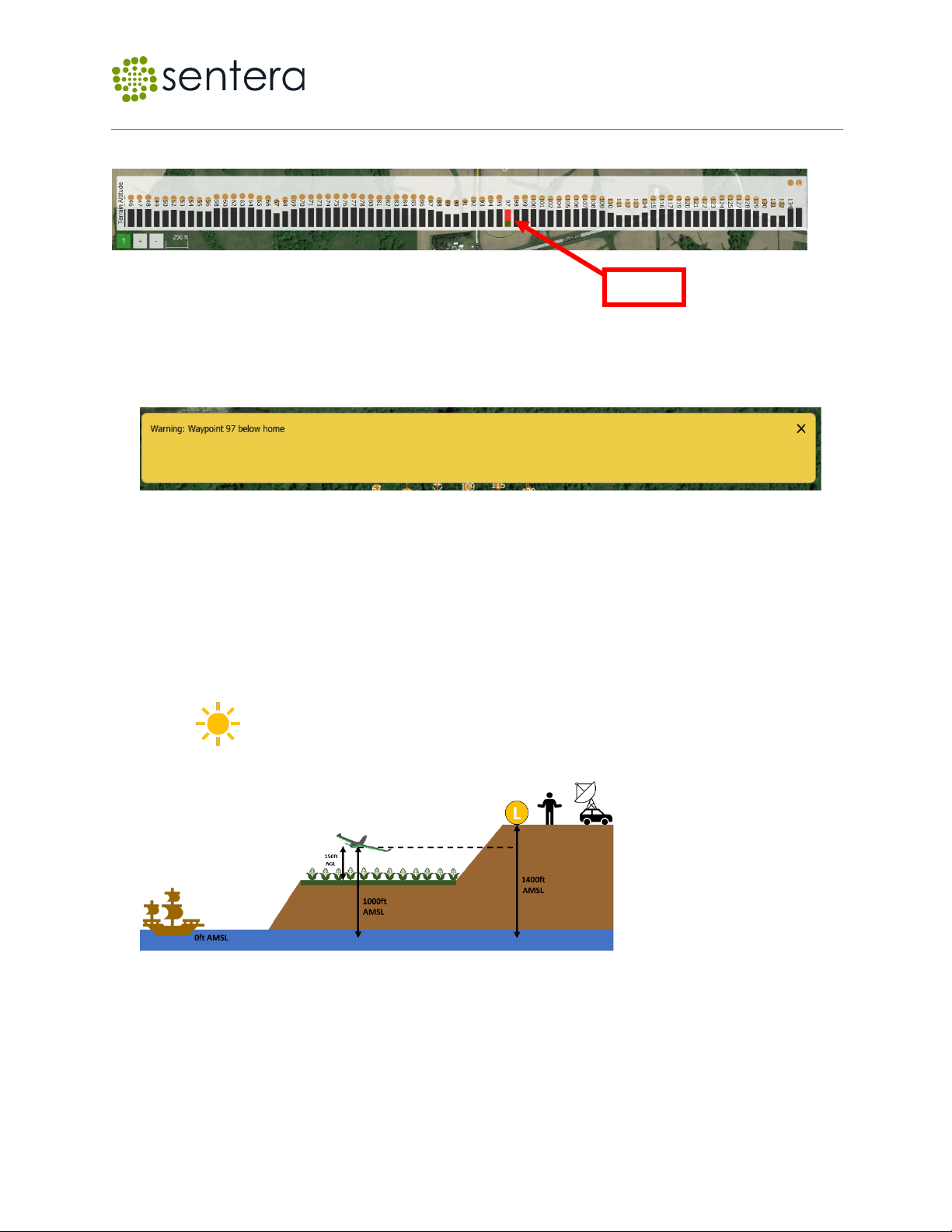
Note: It is important to check that the orange circle that represents flight
altitude never intersects or goes below the black rectangle that represents the
reported terrain elevation.
CHECK ALL POINTS FOR THIS BEFORE EVERY MISSION.
PHX Terrain Following Feature User Guide Rev – Doc # 17030
www.sentera.com Page 11 Updated May 3, 2021
844.SENTERA © 2021 Sentera, LLC. All rights reserved.
Negative terrain interaction may cause the aircraft to impact with the ground, as shown in Figure 13.
Figure 13: Impact
When this occurs and the mission is uploaded, the mission checker may report a warning stating that a
waypoint is below the home point altitude, as shown in Figure 14.
Figure 14: Warning
Manually checking for negative terrain interaction needs to be done even if no warning message
appears.
This warning can also be present when operating from the top of a large elevation change. For example,
if you plan to set up and launch the drone from on top of a hill then survey over a field below the hill. If
the flight altitude over the field is lower than the elevation of the field, then the warning will be sent by
the mission checker, as shown in Figure 15.
Figure 15: Warning
2.5 Offline Maps
A description of the use of offline maps and terrain elevation data.
BAD!

PHX Terrain Following Feature User Guide Rev – Doc # 17030
www.sentera.com Page 12 Updated May 3, 2021
844.SENTERA © 2021 Sentera, LLC. All rights reserved.
2.5.1 Downloading Terrain Elevation Data
Use the offline maps feature as described in the Sentera PHX User Guide to prepare to download map
tiles with terrain elevation data.
Once the map download settings have been chosen, select Fetch elevation data option in the download
menu, as shown in Figure 16.
2.5.1.1 Offline Map Download Menu with Fetch Elevation Data Enabled
Figure 16: Fetch elevation data
Verify that all map and elevation tiles have been downloaded in the offline maps screen.
2.5.1.2 Offline Map Download Verification
Figure 17 displays example of map and elevation tiles that have successfully downloaded.
Figure 17: Elevation Tiles
3Glossary
Definitions of used terms.
AMSL – Above Mean Sea Level.
AGL – Above Ground Level.
GSD – Ground Sample Distance.

PHX Terrain Following Feature User Guide Rev – Doc # 17030
www.sentera.com Page 13 Updated May 3, 2021
844.SENTERA © 2021 Sentera, LLC. All rights reserved.
4Support
Need Support? Email us at support@sentera.com or call us 844-736-8372.
Revision History
This table list the revision history.
Release No.
Date
Revision Description
Rev -
May 3, 2021
Initial document.
[END OF DOCUMENT]
Other manuals for PHX
5
Table of contents
Other Sentera Quadcopter manuals


