Garmin GPSMAP 67 User manual

GPSMAP®67
Owner’s Manual

© 2023 Garmin Ltd. or its subsidiaries
All rights reserved. Under the copyright laws, this manual may not be copied, in whole or in part, without the written consent of Garmin. Garmin reserves the right to change
or improve its products and to make changes in the content of this manual without obligation to notify any person or organization of such changes or improvements. Go to
www.garmin.com for current updates and supplemental information concerning the use of this product.
Garmin®, the Garmin logo, ANT+®, Auto Lap®, AutoLocate®, City Navigator®, GPSMAP®, inReach®, TracBack®, VIRB®, and Xero® are trademarks of Garmin Ltd. or its subsidiaries,
registered in the USA and other countries. BaseCamp™, chirp™, Connect IQ™, Garmin Connect™, Garmin Explore™, Garmin Express™, Garmin HuntView™, and tempe™ are
trademarks of Garmin Ltd. or its subsidiaries. These trademarks may not be used without the express permission of Garmin.
Android™ is a trademark of Google Inc. Apple®, iPhone®, and Mac® are trademarks of Apple Inc., registered in the U.S. and other countries. The BLUETOOTH® word mark and logos
are owned by the Bluetooth SIG, Inc. and any use of such marks by Garmin is under license. iOS® is a registered trademark of Cisco Systems, Inc. used under license by Apple Inc.
microSD® and the microSDHC logo are trademarks of SD-3C, LLC. NMEA® is a registered trademark of the National Marine Electronics Association. Wi‑Fi® is a registered mark of
Wi-Fi Alliance Corporation. Windows® is a registered trademark of Microsoft Corporation in the United States and other countries. Other trademarks and trade names are those of their
respective owners.

Table of Contents
Introduction......................................1
GPSMAP 67 Device Overview.................1
Charging the GPSMAP 67 Device.......2
Buttons.....................................................3
Turning On the Device......................... 3
Locking the Buttons............................ 3
Turning On the Backlight.....................3
Adjusting the Backlight....................... 4
Acquiring Satellite Signals...................... 4
GPS and Other Satellite Systems....... 4
Using the Main Pages....................... 4
Opening the Main Menu..........................4
Map.......................................................... 4
Navigating with the Map..................... 5
Measuring Distance on the Map........ 5
Map Page Settings.............................. 5
Map Settings.................................... 5
Advanced Map Settings.................. 6
Compass.................................................. 6
Navigating with the Compass............ 6
Using the Course Pointer.................... 7
Navigating with Sight 'N Go................ 7
Projecting a Waypoint from Your
Current Location.................................. 8
Compass Settings............................... 8
Calibrating the Compass.................8
Heading Settings............................. 9
Trip Computer......................................... 9
Trip Computer Settings....................... 9
Altimeter.................................................. 9
Altimeter Plot Settings...................... 10
Altimeter Settings.......................... 10
Calibrating the Barometric
Altimeter.........................................10
Navigation...................................... 10
FIND Page.............................................. 10
Navigating to a Destination.............. 11
Stopping Navigation...................... 11
Finding a Location Near Another
Location............................................. 11
Waypoints.............................................. 11
Saving Your Current Location as a
Waypoint............................................ 11
Saving a Location on the Map as a
Waypoint............................................ 11
Navigating to a Waypoint..................11
Finding a Saved Waypoint................ 12
Editing a Waypoint............................ 12
Deleting a Waypoint.......................... 12
Changing the Photo for a
Waypoint............................................ 12
Increasing the Accuracy of a Waypoint
Location............................................. 12
Projecting a Waypoint from a Saved
Waypoint............................................ 13
Moving a Waypoint on the Map........13
Finding a Location Near a
Waypoint............................................ 13
Setting a Waypoint Proximity
Alarm.................................................. 13
Adding a Waypoint to a Route.......... 14
Repositioning a Waypoint to Your
Current Location................................ 14
Routes.................................................... 14
Creating a Route Using Route
Planner............................................... 14
Creating a Route Using the Map.......14
Navigating a Saved Route.................14
Viewing the Active Route.............. 15
Editing a Route.................................. 15
Editing the Name of a Route.............15
Viewing a Route on the Map............. 15
Viewing the Elevation Plot of a
Route.................................................. 15
Reversing a Route............................. 16
Deleting a Route................................ 16
Recordings.............................................16
Recording Settings............................ 16
Advanced Recording Settings...... 16
Auto Save Settings........................ 17
Viewing the Current Activity............. 17
Navigating Using TracBack®........... 17
Stopping the Current Activity............17
Saving the Current Activity............... 18
Viewing Saved Activity
Information.................................... 18
Saving a Location from an Activity
as a Waypoint................................ 18
Creating a Track from a Saved
Activity............................................18
Reversing an Activity..................... 18
Table of Contents i

Navigating a Saved Activity.......... 18
Deleting a Saved Activity...............19
Courses.................................................. 19
Creating a Course..............................19
Creating a Course Using the Map.... 19
Navigating a Saved Course...............19
Editing a Course................................ 20
Editing the Name of a Course.......... 20
Viewing a Saved Course on the
Map.................................................... 20
Viewing the Elevation Plot of a
Course................................................ 20
Reversing a Course........................... 21
Creating a Track or Route from a
Saved Course.....................................21
Deleting a Course.............................. 21
Optional Maps....................................... 21
Purchasing Additional Maps............ 21
Finding an Address........................... 21
Connected Features....................... 22
Connected Feature Requirements....... 22
Pairing a Smartphone with Your
Device.................................................... 23
Phone Notifications.............................. 23
Viewing Phone Notifications............ 23
Hiding Notifications.......................... 23
Managing Notifications.................... 23
Connecting to a Wireless Network.......23
Connect IQ Features............................. 23
Downloading Connect IQ Features.. 24
Downloading Connect IQ Features
Using Your Computer........................ 24
Viewing Connect IQ Widgets............ 24
Garmin Explore...................................... 24
Main Menu Tools............................25
Viewing an Active Weather Forecast... 26
Viewing an Active Weather Map...... 26
Adding an Active Weather
Location............................................. 26
Switching the Active Weather
Location......................................... 27
Deleting an Active Weather
Location......................................... 27
Garmin Adventures............................... 27
Sending Files to and from
BaseCamp......................................... 27
Creating an Adventure...................... 27
Starting an Adventure....................... 28
Calculating the Size of an Area............ 28
Using the Flashlight.............................. 28
Geocaches............................................. 28
Registering Your Device at
Geocaching.com............................... 29
Connecting to Geocaching.com... 29
Downloading Geocaches Using a
Computer........................................... 29
Searching for a Geocache................ 29
Searching for a Geocache on the
Map.................................................... 30
Filtering the Geocache List............... 30
Saving a Custom Geocache
Filter................................................30
Editing a Custom Geocache
Filter................................................30
Viewing Geocache Details................ 30
Navigating to a Geocache................ 31
Using Hints and Clues to find a
Geocache....................................... 31
Logging the Attempt......................... 31
chirp................................................... 31
Enabling chirp Searching.............. 31
Finding a Geocache with a chirp.. 31
Removing Live Geocache Data from
the Device.......................................... 32
Removing Your Device Registration
From Geocaching.com..................... 32
Marking and Starting Navigation to a
Man Overboard Location...................... 32
Downloading Maps............................... 32
Enabling Maps................................... 33
Deleting a Map...................................33
Selecting a Profile................................. 33
Setting a Proximity Alarm..................... 33
Editing or Deleting a Proximity
Alarm.................................................. 33
Satellite Page........................................ 33
GPS Satellite Settings....................... 34
Sending and Receiving Data
Wirelessly.............................................. 34
Using the VIRB Remote.........................34
Using the inReach Remote................... 35
Customizing the Device.................. 35
Customizing the Data Fields................ 35
ii Table of Contents

Setup Menu........................................... 36
System Settings................................ 36
Satellite Settings............................36
Display Settings................................. 37
Turning Off the Screen.................. 37
Changing the Color Mode............. 37
Bluetooth Settings............................. 37
Wi‑Fi Settings..................................... 37
Routing Settings................................ 38
Advanced Routing Settings...........38
Turning On Expedition Mode............ 38
Setting the Device Tones.................. 38
Geocaching Settings......................... 39
Pairing Your Wireless Sensors......... 39
Fitness Settings................................. 39
Marking Laps by Distance.............39
Marine Settings................................. 40
Setting Up Marine Alarms............. 40
Menu Settings....................................40
Customizing the Main Menu......... 40
Changing the Page Sequence.......41
Configuring the Page Ribbon
Display............................................ 41
Position Format Settings.................. 41
Changing the Units of Measure........ 42
Time Settings.................................... 42
Profiles............................................... 42
Creating a Custom Profile.............42
Editing a Profile Name.................. 42
Deleting a Profile........................... 43
Resetting Data and Settings............. 43
Restoring Default Page Settings.. 43
Device Information......................... 43
Product Updates................................... 43
Setting Up Garmin Express............... 43
Getting More Information..................... 44
Attaching the Carabiner Clip................ 44
Removing the Carabiner Clip............ 44
Attaching a Lanyard.............................. 44
Device Care............................................45
Cleaning the Device...........................45
Data Management................................ 45
File Types........................................... 45
Installing a Memory Card..................45
Connecting the Device to Your
Computer........................................... 46
Transferring Files to Your Device..... 46
Deleting Files..................................... 46
Disconnecting the USB Cable........... 46
Specifications........................................47
Viewing E-label Regulatory and
Compliance Information....................... 47
Appendix........................................ 48
Data Fields............................................. 48
Optional Accessories............................ 50
tempe................................................. 50
Tips for Pairing Wireless Sensors.... 51
Troubleshooting.................................... 51
Maximizing Battery Life.................... 51
Long-Term Storage........................... 51
Restarting the Device........................ 51
About Heart Rate Zones....................... 51
Fitness Goals..................................... 51
Heart Rate Zone Calculations...........52
Table of Contents iii


Introduction
WARNING
See the Important Safety and Product Information guide in the product box for product warnings and other
important information.
GPSMAP 67 Device Overview
GNSS antenna
Status LED
Power button
Buttons
USB port (under weather cap)
Flashlight
microSD® card slot (under weather cap)
Mounting spine
Introduction 1

Charging the GPSMAP 67 Device
NOTICE
To prevent corrosion, thoroughly dry the USB port, the weather cap, and the surrounding area before charging or
connecting to a computer.
NOTE: The device does not charge when it is outside the approved temperature range (Specifications,
page47).
1Lift the weather cap .
2Plug the small end of the power cable into the charging port on the device.
3Plug the other end of the power cable into a compatible AC power adapter.
4Plug the AC power adapter into a standard wall outlet.
The device displays the current battery charge level.
2 Introduction
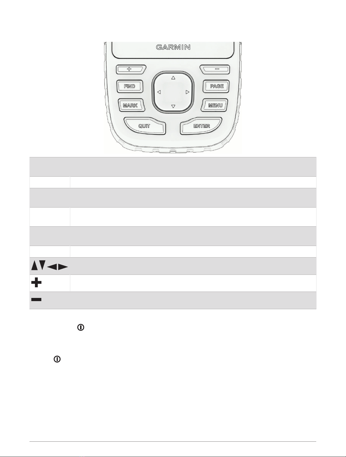
Buttons
FIND Press to open the search menu.
Hold to mark your current location as a man overboard (MOB) location and activate navigation.
MARK Press to save your current location as a waypoint.
QUIT Press to cancel or return to the previous menu or page.
Press to scroll through the main pages.
ENTER Press to choose options and acknowledge messages.
Press to control the current activity recording (from the main pages).
MENU Press to open the options menu for the page that is currently open.
Press twice to open the main menu (from any page).
PAGE Press to scroll through the main pages.
Press to select menu options and move the map cursor.
Press to zoom in on the map.
Press to zoom out on the map.
Turning On the Device
Press and hold .
Locking the Buttons
You can lock the keypad to prevent inadvertent button presses.
1Press to open the status page.
2Select Lock Keys.
Turning On the Backlight
Press any button to turn on the backlight.
The backlight turns on automatically when alerts and messages are displayed.
Introduction 3

Adjusting the Backlight
1Press to open the status page.
2Use and to adjust the brightness.
NOTE: To maximize battery life, the screen turns off automatically when the backlight times out. You can
select Setup > Display to customize the backlight and display settings.
Acquiring Satellite Signals
It may take 30 to 60 seconds to acquire satellite signals.
1Go outdoors to an open area.
2If necessary, turn on the device.
3Wait while the device searches for satellites.
flashes while the device determines your GNSS location.
in the status bar shows the satellite signal strength.
When the device acquires satellite signals, it automatically starts recording your path as an activity.
GPS and Other Satellite Systems
Using GPSand another satellite system together offers increased performance in challenging environments and
faster position acquisition than using GPS only. However, using multiple systems can reduce battery life more
quickly than using GPS only.
Your device can use these Global Navigation Satellite Systems (GNSS). Multi-band systems use multiple
frequency bands and allow for more consistent track logs, improved positioning, improved multi-path errors,
and fewer atmospheric errors when using the device in challenging environments.
NOTE: You can view satellite locations and available satellite systems on the satellite page (Satellite Page,
page33).
GPS: A satellite constellation built by the United States.
GPS multi-band: A satellite constellation built by the United States, using the enhanced L5 signal.
GLONASS: A satellite constellation built by Russia.
GALILEO: A satellite constellation built by the European Space Agency.
GALILEO multi-band: A satellite constellation built by the European Space Agency, using the enhanced L5
signal.
QZSS multi-band: A satellite constellation built by Japan, using the enhanced L5 signal.
IRNSS (NavIC): A satellite constellation built by India, using the enhanced L5 signal.
Using the Main Pages
The information needed to operate this device is found on the main menu, map, compass, and trip computer
pages.
Press PAGE or QUIT to scroll through the main pages.
The page displayed in the middle opens automatically.
Opening the Main Menu
The main menu gives you access to tools and setup screens for waypoints, activities, routes, and more (Main
Menu Tools, page25, Setup Menu, page36).
From any page, press MENU twice.
Map
represents your location on the map. As you travel, moves and displays your path. Depending on your zoom
level, waypoint names and symbols may appear on the map. You can zoom in on the map to see more detail.
When you are navigating to a destination, your route is marked with a colored line on the map.
4 Using the Main Pages

Navigating with the Map
1Begin navigating to a destination (Navigating to a Destination, page11).
2Press PAGE to scroll to the map page.
A blue triangle represents your location on the map. As you travel, the blue triangle moves and displays your
path.
3Complete one or more actions:
• To view different areas of the map, press , , , or .
• To zoom in and out of the map, press and .
• To view more information about a waypoint on the map (represented by an icon) or other location, move
the map cursor to the location, and press ENTER.
Measuring Distance on the Map
You can measure the distance between multiple locations.
1Press PAGE to scroll to the map page.
2Press MENU.
3Select Measure Distance.
4Press , , , and to move the map cursor to a location.
The measured distance appears.
5Press ENTER to select additional locations on the map.
Map Page Settings
Press PAGE to scroll to the map page, and press MENU.
Show Dashboard: Allows you to show or hide the dashboard after setting one to display on the map (Map
Settings, page5).
Stop Navigation: Stops navigating the current route.
Map Setup: Allows you to customize additional map settings (Map Settings, page5).
Measure Distance: Allows you to measure the distance between multiple locations (Measuring Distance on the
Map, page5).
Change Data Fields: Allows you to customize the data fields on the dashboard.
Restore Defaults: Restores the map to factory default settings.
Map Settings
Press PAGE to scroll to the map page, and press MENU. Select Map Setup.
Map Manager: Shows the downloaded map versions. With an Outdoor Maps+ subscription, allows you to
download additional maps (Downloading Maps, page32).
Orientation: Adjusts how the map is shown on the page (Changing the Map Orientation, page6).
Dashboard: Sets a dashboard to display on the map. Each dashboard shows different information about your
route or your location.
NOTE: Your customized settings are remembered by the dashboard. Your settings are not lost when you
change profiles (Profiles, page42).
Guidance Text: Sets when the guidance text is shown on the map.
Advanced Setup: Allows you to customize advanced map settings (Advanced Map Settings, page6).
Using the Main Pages 5

Changing the Map Orientation
1Press PAGE to scroll to the map page.
2Press MENU.
3Select Map Setup > Orientation.
4Select an option:
• Select North Up to show north at the top of the page.
• Select Track Up to show your current direction of travel at the top of the page.
• Select Automotive Mode to show an automotive perspective with the direction of travel at the top.
Advanced Map Settings
Press PAGE to scroll to the map page, and press MENU. Select Map Setup > Advanced Setup.
Auto Zoom: Automatically selects the appropriate zoom level for optimal use on your map. When Off is
selected, you must zoom in or out manually.
Detail: Sets the amount of detail shown on the map. Showing more detail may cause the map to redraw more
slowly.
Shaded Relief: Shows detail relief on the map, if available, or turns off shading.
Vehicle: Sets the position icon, which represents your position on the map. The default icon is a small blue
triangle.
Zoom Levels: Adjusts the zoom level at which map items appear. The map items do not appear when the map
zoom level is higher than the selected level.
Text Size: Sets the text size for map items.
Compass
When navigating, points to your destination, regardless of the direction you are moving. When points
toward the top of the electronic compass, you are traveling directly toward your destination. If points any
other direction, turn until it points toward the top of the compass.
Navigating with the Compass
When navigating to a destination, points to your destination, regardless of the direction you are moving.
1Begin navigating to a destination (Navigating to a Destination, page11).
2Press PAGE to scroll to the compass page.
3Turn until points toward the top of the compass, and continue moving in that direction to the destination.
6 Using the Main Pages

Using the Course Pointer
The course pointer is most useful when you are navigating to your destination in a straight line, such as when
you are navigating on water. It can help you navigate back to the course line when you go off-course to avoid
obstacles or hazards.
1Press PAGE to scroll to the compass page.
2Press MENU.
3Select Heading Setup > Go To Line (Pointer) > Course (CDI) to enable the course pointer.
Course line pointer. Indicates the direction of the desired course line from your starting point to your
next waypoint.
Course deviation indicator (CDI). Indicates the location of the desired course line in relation to your
location. If the CDI is aligned with the course line pointer, you are on course.
Course deviation distance. The dots indicate your distance off course. The distance represented by
each dot is indicated by the scale in the upper-right corner.
To-and-from indicator. Indicates whether you are headed to or away from the next waypoint.
Navigating with Sight 'N Go
You can point the device at an object in the distance with the compass direction locked in, project the object as
a waypoint, and navigate using the object as a reference point.
1Press PAGE to scroll to the compass page.
2Press MENU.
3Select Sight 'N Go.
4Point the device at an object.
5Select Lock Direction > Set Course.
6Navigate using the compass.
Using the Main Pages 7

Projecting a Waypoint from Your Current Location
You can save a new waypoint by projecting the distance from your current location.
For example, if you would like to navigate to a location you observe on the other side of a river or stream,
you can project a waypoint from your current location to the observed location, and then navigate to the new
location after you cross the river or stream.
1Press PAGE to scroll to the compass page.
2Press MENU.
3Select Sight 'N Go.
4Point the device at the new location.
5Select Lock Direction > Project Waypoint.
6Select a unit of measure.
7Enter the distance, and select Done.
8Select Save.
Compass Settings
Press PAGE to scroll to the compass page, and press MENU.
Sight 'N Go: Allows you to point the device at an object in the distance, and navigate using the object as a
reference point (Navigating with Sight 'N Go, page7).
Stop Navigation: Stops navigation of the current route.
Change Dashboard: Changes the theme and information displayed on the dashboard.
NOTE: Your customized settings are remembered by the dashboard. Your settings are not lost when you
change profiles (Profiles, page42).
Set Scale: Sets the scale for the distance between the dots on the course deviation indicator when navigating
with Sight 'N Go.
Calibrate Compass: Allows you to calibrate the compass if you experience irregular compass behavior. For
example, after moving long distances or after extreme temperature changes (Calibrating the Compass,
page8).
Heading Setup: Allows you to customize the compass heading settings (Heading Settings, page9).
Change Data Fields: Allows you to customize the compass data fields.
Restore Defaults: Restores the compass to factory default settings.
Calibrating the Compass
Before you can calibrate the electronic compass, you must be outdoors, away from objects that influence
magnetic fields, such as cars, buildings, or overhead power lines.
The GPSMAP 67 device has a 3-axis electronic compass. You should calibrate the compass after moving long
distances or experiencing temperature changes.
1Press PAGE to scroll to the compass page.
2Press MENU.
3Select Calibrate Compass > Start.
4Follow the on-screen instructions.
8 Using the Main Pages

Heading Settings
Press PAGE to scroll to the compass page, and press MENU. Select Heading Setup.
Display: Sets the directional heading on the compass to letters, degrees, or milliradians.
North Reference: Sets the north reference used on the compass (Setting the North Reference, page9).
Go To Line (Pointer): Sets the behavior of the pointer that appears on the map. Bearing points in the direction of
your destination. Course (CDI) shows your relationship to the course line leading to the destination.
Compass: Automatically switches from an electronic compass to a GPS compass when you are traveling at a
higher rate of speed for a period of time.
Calibrate Compass: Allows you to calibrate the compass if you experience irregular compass behavior. For
example, after moving long distances or after extreme temperature changes (Calibrating the Compass,
page8).
Setting the North Reference
You can set the directional reference used in calculating heading information.
1Press PAGE to scroll to the compass page.
2Press MENU.
3Select Heading Setup > North Reference.
4Select an option:
• To set geographic north as the heading reference, select True.
• To set the magnetic declination for your location automatically, select Magnetic.
• To set grid north (000 degrees) as the heading reference, select Grid.
• To set the magnetic variation value manually, select User, enter the magnetic variance, and select Done.
Trip Computer
The trip computer displays your current speed, average speed, trip odometer, and other helpful statistics. You
can customize the trip computer layout, dashboard, and data fields.
Trip Computer Settings
Press PAGE to scroll to the trip computer page, and press MENU.
Reset: Resets all the trip computer values to zero. For accurate information, reset the trip information before
beginning a trip.
Change Data Fields: Customizes the trip computer data fields.
Change Dashboard: Changes the theme and information displayed on the dashboard.
NOTE: Your customized settings are remembered by the dashboard. Your settings are not lost when you
change profiles (Profiles, page42).
Insert Page: Inserts an additional page of customizable data fields.
TIP: You can use the arrow buttons to scroll through the pages.
Remove Page: Removes an additional page of customizable data fields.
More Data: Adds additional data fields to the trip computer.
Less Data: Removes data fields from the trip computer.
Restore Defaults: Restores the trip computer to its factory default settings.
Altimeter
By default, the altimeter displays the elevation over the distance traveled. You can customize altimeter settings
(Altimeter Settings, page10). You can select any point on the plot to view details about that point.
Using the Main Pages 9

Altimeter Plot Settings
Press PAGE to scroll to the altimeter page, and press MENU.
Reset: Resets the altimeter data, including waypoint, track, and trip data.
Altimeter Setup: Enables you to open additional altimeter settings (Altimeter Settings, page10).
Adjust Zoom Ranges: Adjusts the zoom ranges shown on the altimeter page.
Change Data Fields: Allows you to customize the altimeter data fields.
Restore Defaults: Restores the altimeter to factory default settings.
Altimeter Settings
Press PAGE to scroll to the altimeter page, and press MENU. Select Altimeter Setup.
Auto Calibration: Once allows the altimeter to automatically calibrate one time when you start an activity.
Continuous allows the altimeter to calibrate throughout the duration of your activity.
Barometer Mode: Variable Elevation allows the barometer to measure changes in elevation while you are
moving. Fixed Elevation assumes the navigator is stationary at a fixed elevation, so the barometric pressure
should only change due to weather.
Pressure Trending: Sets how the navigator records pressure data. Save Always records all pressure data, which
can be helpful when you are watching for pressure fronts.
Plot Type: Records elevation changes over a period of time or distance, records barometric pressure over a
period of time, or records ambient pressure changes over a period of time.
Calibrate Altimeter: Allows you to manually calibrate the barometric altimeter (Calibrating the Barometric
Altimeter, page10).
Calibrating the Barometric Altimeter
You can manually calibrate the barometric altimeter if you know the correct elevation or the correct barometric
pressure.
1Go to a location where the elevation or barometric pressure is known.
2Press PAGE to scroll to the altimeter page.
3Press MENU.
4Select Altimeter Setup > Calibrate Altimeter.
5Select Method to select the measurement to use in calibration.
6Enter the measurement.
7Select Calibrate.
Navigation
You can use the GPS navigation features on your device to navigate a saved activity, route, or course.
• Your device records your path as an activity. Activities use corridor navigation. When navigating a saved
activity, it cannot be recalculated (Recordings, page16).
• A route is a sequence of waypoints or locations that leads you to your destination. If you depart from the
original route, the device recalculates the route and provides new directions (Routes, page14).
• A course can have multiple destinations, and can be created point to point or on routable roads. When
navigating a saved course, you can choose to navigate using the direct path with no map adjustments or
recalculations, or following roads and trails with recalculations as needed. You can convert saved activities
and routes to courses (Courses, page19).
FIND Page
You can use the Find page to find a destination to navigate to. Not all FIND categories are available in all areas
and maps.
10 Navigation

Navigating to a Destination
1Press FIND.
2Select a category.
3If necessary, press MENU to narrow the search.
4If necessary, select Spell Search, and enter the destination name or part of the name.
5Select a destination.
6Select Go.
Your route appears as a magenta line on the map.
7Navigate using the map (Navigating with the Map, page5) or compass (Navigating with the Compass,
page6).
Stopping Navigation
1Press FIND.
2Select Stop Navigation.
Finding a Location Near Another Location
1Press FIND.
2Press MENU.
3Select Search Near, and select an option.
4Select a location.
Waypoints
Waypoints are locations you record and store in the device. Waypoints can mark where you are, where you are
going, or where you have been. You can add details about the location, such as name, elevation, and depth.
You can add a .gpx file that contains waypoints by transferring the file to the GPX folder (Transferring Files to
Your Device, page46).
Saving Your Current Location as a Waypoint
1Press MARK.
2If necessary, select a field to edit information about the waypoint, such as the name or location.
3Select Save.
Saving a Location on the Map as a Waypoint
You can save a location on the map as a waypoint.
1Press PAGE to scroll to the map page.
2Press , , , or to move the cursor to a location.
An information bar appears at the top of the screen.
3Press ENTER.
4Press MENU.
5Select Save as Waypoint.
Navigating to a Waypoint
1Press FIND.
2Select Waypoints.
3Select a waypoint.
4Select Go.
By default, your route to the waypoint appears as a straight, colored line on the map.
Navigation 11

Finding a Saved Waypoint
1Press MENU twice to open the main menu.
2Select Waypoint Manager.
3If necessary, press MENU to narrow the search.
4If necessary, select an option:
• Select Spell Search to search using the name of the waypoint.
• Select Search Near to search near a recently found location, another waypoint, your current location, or a
point on the map.
• Select Sort to view the list of waypoints based on nearest distance or alphabetical order.
5Select a waypoint from the list.
Editing a Waypoint
1Press MENU twice to open the main menu.
2Select Waypoint Manager.
3Select a saved waypoint.
4Select an item to edit, such as the name or location.
5Enter the new information, and select Done.
Deleting a Waypoint
1Press MENU twice to open the main menu.
2Select Waypoint Manager.
3Select a waypoint.
4Press MENU.
5Select Delete.
Changing the Photo for a Waypoint
1Press MENU twice to open the main menu.
2Select Waypoint Manager.
3Select a waypoint.
4Press MENU.
5Select Change Photo.
6Select a photo.
7Select Use.
Increasing the Accuracy of a Waypoint Location
You can refine the accuracy of a waypoint location by averaging the location data. When averaging, the device
takes several GPS readings at the same location and uses the average value to provide more accuracy.
1Press MENU twice to open the main menu.
2Select Waypoint Manager.
3Select a waypoint.
4Press MENU.
5Select Average Location.
6Move to the waypoint location.
7Select Start.
8Follow the on-screen instructions.
9When the confidence status bar reaches 100%, select Save.
For best results, collect four to eight samples for the waypoint, waiting at least 90 minutes between samples.
12 Navigation

Projecting a Waypoint from a Saved Waypoint
You can save a new waypoint by projecting the distance and bearing from a saved waypoint to a new location.
1Press MENU twice to open the main menu.
2Select Waypoint Manager.
3Select a waypoint.
4Press MENU.
5Select Project Waypoint.
6Enter the bearing, and select Done.
7Select a unit of measure.
8Enter the distance, and select Done.
9Select Save.
Moving a Waypoint on the Map
1Press MENU twice to open the main menu.
2Select Waypoint Manager.
3Select a waypoint.
4Press MENU.
5Select Move Waypoint.
6Press , , , or to move the cursor to a new location on the map.
7Select Move.
Finding a Location Near a Waypoint
1Press MENU twice to open the main menu.
2Select Waypoint Manager.
3Select a waypoint.
4Press MENU.
5Select Find Near Here.
6Select a category.
The list displays locations near the selected waypoint.
Setting a Waypoint Proximity Alarm
You can add a proximity alarm for a waypoint. Proximity alarms alert you when you are within a specified range
of a particular location.
1Press MENU twice to open the main menu.
2Select Waypoint Manager.
3Select a waypoint.
4Press MENU.
5Select Set Proximity.
6Enter the radius.
When you enter an area with a proximity alarm, the device sounds a tone.
Navigation 13

Adding a Waypoint to a Route
1Press MENU twice to open the main menu.
2Select Waypoint Manager.
3Select a waypoint.
4Press MENU.
5Select Add to Route.
6Select a route.
Repositioning a Waypoint to Your Current Location
You can change the position of a waypoint. For example, if you move your vehicle, you can change the location
to your current position.
1Press MENU twice to open the main menu.
2Select Waypoint Manager.
3Select a waypoint.
4Press MENU.
5Select Reposition Here.
The waypoint location changes to your current location.
Routes
A route is a sequence of waypoints or locations that leads you to your final destination. Routes are saved as
GPX files on the device.
Creating a Route Using Route Planner
A route can include many waypoints, and it should include at least a starting point and one destination.
1Press MENU twice to open the main menu.
2Select Route Planner > Create Route > Select First Point.
3Select a category.
4Select the first point in the route.
5Select Use.
6Select Select Next Point to add additional points to the route.
7Select QUIT to save the route.
Creating a Route Using the Map
1Press MENU twice to open the main menu.
2Select Route Planner > Create Route > Select First Point > Use Map.
3Press , , , or to select a point on the map.
4Select Use.
5Repeat steps 3 and 4 to select additional points on the map to add to the route (optional).
6Select QUIT.
Navigating a Saved Route
1Press FIND.
2Select Routes.
3Select a route.
4Select Go.
By default, your route appears as a straight, colored line on the map.
14 Navigation
Other manuals for GPSMAP 67
2
Table of contents


