Locosys GT-31 User manual

G
GT
T-
-3
31
1
B
BG
GT
T-
-3
31
1
O
Ow
wn
ne
er
r’
’s
s
M
Ma
an
nu
ua
al
l
V
Ve
er
rs
si
io
on
n
0
0.
.4
4

Congratulations for choosing GT-31!We hope you will agree it is an
excellent navigator. We want you to have a very pleasant outdoor
experience with GT-31 so please check the content in the package first. If
you find any items missing, please contact the authorized dealer
immediately. All our dealers are ready and willing to help.
This manual provides detailed instructions for operating GT-31. To fully
understand all the features and functions, please take time to read through
this manual before using your GT-31. Some useful tips are also included
in this manual. We hope GT-31 will enhance your enjoyment of outdoor
activities.
Please visit www.locosystech.com and send us your comments. From
time to time, we will have updates and upgrades available - based on your
suggestions and recommendations. Have fun with your GT-31!
Sincerely yours,
LOCOSYS Technology Incorporated
Package Check List
Standard package:
1GT-31
1 USB data/charge cable
1 Installation CD,
containing
Owner’s Manual, Drivers,
and Utilities
* Contact your dealer if any
parts are missing.
Options:
- USB Car Charger
- USB Travel AC/DC
adapter
- Bike Mounting Kit
- Arm Strap
* Ask your dealer for detail
Welcome
2

Taking your eyes off the road can cause accidents and serious damage or personal injury. Do not operate GT-31
while driving or riding. Come to a complete stop or have your passenger make any changes. Do not secure GT-31
over airbag panels or in a place where the driver or passengers are likely to come into contact with it in the event of an
accident or collision. Never dispose of the GT-31 in a fire. This can cause the built-in lithium-ion polymer
rechargeable battery to explode. If, for any reason, the electrolytic liquid of the battery comes into contact with the
skin or the eyes, flush with plenty of water and call for medical help immediately.
The GPS system is operated and maintained by the government of the
United States, which is solely responsible for the accuracy and maintenance of
the GPS. The system is subject to change which could affect the accuracy and
performance of all GPS equipment.
Accuracy can also be affected by poor satellite geometry and by various
other causes. Do not rely solely on this device for precision measurement or
navigation.
I know it’s pretty. But …
taking your eyes off the
road can cause
accidents and
serious damage or
p
ersonal injury.
Warning and Cautions
The GT-31 does not contain any user serviceable parts. Please contact
our authorized dealers for repair. Unauthorized repair will void the warranty.
3

Welcome
Warnings and Cautions
Table of Contents
Introduction
Controls
Power/ESC Button
Thumb Stick Operation
Hold Key
Before Getting Started
Status Indicators
Introduction to the pages
Page System Tree
Main Menu
Satellite Signal
Trip Meter
Speed
Navigation
Track
Position Mark
Waypoint
Route
2
3
4
5
7
7
7
7
8
9
10
10
13
14
15
17
19
22
28
29
33
Memory Card
Data Logger
Alert
NAVILINK
Settings
Miscellanies
How to.
Track back to where you came from
Calculate the area
Activate Speed Genie
Download and upload data
Update firmware
Map Datum List
Water Immersion
Warranty and Repair
36
39
40
42
43
51
52
52
54
55
57
63
64
72
73
Table of Contents
Treasure your
GT-31 GPS the
same way treasure
your sailboat
4
Introduction
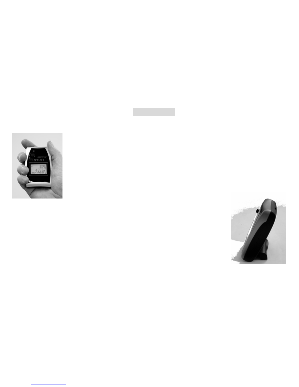
The GT-31 is a wonderfully compact, business card sized navigator, carefully designed to
embody ergonomic principles. It will comfortably fit in the palm of your hand, mount on the
handlebar of bike or motorcycle, and can even be worn on your arm. The stylish unit can
stand on your desk as a funky gadget, or, more usefully, can be placed on the dashboard in
your car.
The GT-31 can run for up to 46 hours in power saving mode, backlight off with the built-in
lithium ion polymer rechargeable battery. It can be recharged while connected to car
cigarette lighter, mains power outlet, or your PC/Notebook. When traveling where no car or
mains power is available, you may purchase an AA battery adapter, or a rechargeable power
bank (Solar charger) to extend the usage.
A state-of-the-art Thumb Stick (TS) allows for simple, one-handed
operation. This rugged navigator is waterproof to IPX7 standards or, immersible in the
water for 30 minutes at a depth of 1 meter, and, it floats!
GT-31 is not only developed to handle outdoor activities, but also to handle
various professional uses, such as speed, hazard area, zone alerts, altitude or other alerts defined
by the user. To store trip data for longer journeys, there is a SD/MMC slot for extra data storage
capacity. And, it can be used as a Real-Time GPS
Receiver by connecting to your PC/Notebook.
5

Introduction (continued)
Thumb
Stick
Power/ESC
Button
LED Internal Buzzer
Strap Hole
Mounting Screw Holes
BOTTOM
USB Slot
FRONT
Built-in
Antenna
Built-in Rechargeable Battery
Waterproof
compartment
BACK
SD/MMC Card Slot
LCD
6
Controls
7
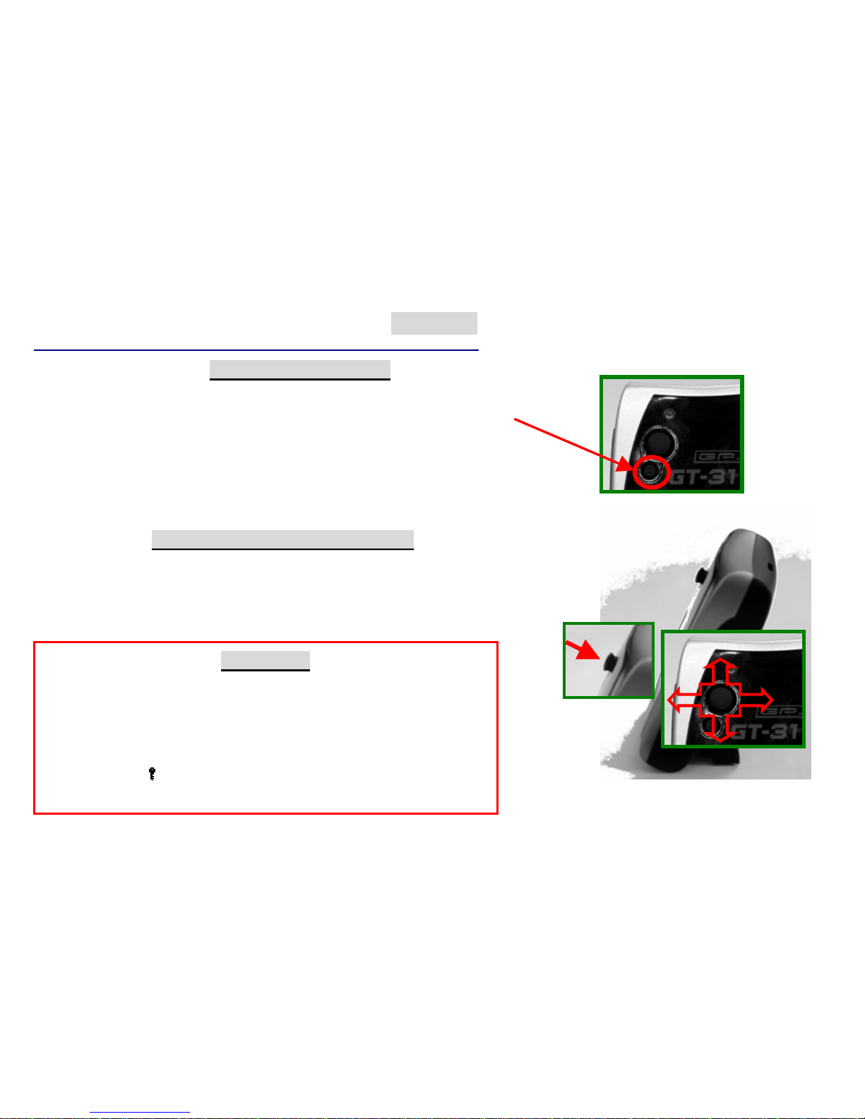
THUMB STICK (TS) OPREATION
It’s a 5-way directional controller.
Move the TS Up, Down, Left or Right to highlight the option.
Press In the TS to confirm, or execute the option.
Press Power/ESC button to escape the current page. Press In
POWER/ESC BUTTON
Press this button and hold to Power ON or Power OFF
When power is turned on this button functions the same as ESC.
Press in to escape the current page
Under any Main Pages, it is also used as a toggle key to turn on/off LCM
backlight if [SETTINGS]/[BACKLIGHT] is set to ON and [SETTINGS]
\[BACKLIGHT TIME] is set to OFF.
HOLD KEY
At any stage, press In and Hold the TS to activate hold key
function. The hold key function can be defined in [SETTINGS]
/[HOLD KEY]. If [MARK] is defined, HOLD KEY will save the
current location if available, as a new waypoint. If [KEY LOCK]
is defined, HOLD KEY is used to lock or unlock TS and ESC.
The key icon( ) shown in status bar indicates the unit is in key
lock stage.

.
GT-31 is designed for easy operation. If this is your first time to own a GPS navigator, just follow the
instructions in the following pages and you will quickly get familiar with this unit.
Before Getting Started
Before Use
1) Charge the battery. It takes around 4 hours for the
built-in battery to be fully charged.
2) Initialize the receiver. Leave the GT-31outside with
a clear view of sky until it gets position fix. Afte
r
that, it needs only around 45 seconds to find its
location. When the unit has not been used for long
time or it’s taken to a far distance from where you
initialized it, you will need to re-initialize the unit
before use.
3) Configure the system. Set up the parameters
under the [SETTINGS] page. The system will store
your configuration in its built-in flash memory.
4) Consult with your dealer or contact us. If you
have any question about setting up the GT-31 we will
be pleased to assist you to get familiar with the unit.
5) Mark and edit waypoints, and create a route
(refer to [MARK], [WAYPOINT] and [ROUTE]
pages for details)
GT-31 can now tell you:
Where you are
Where you have been
Where you are going
How did you made up your trip, and
Many other interesting possibilities…
8
9
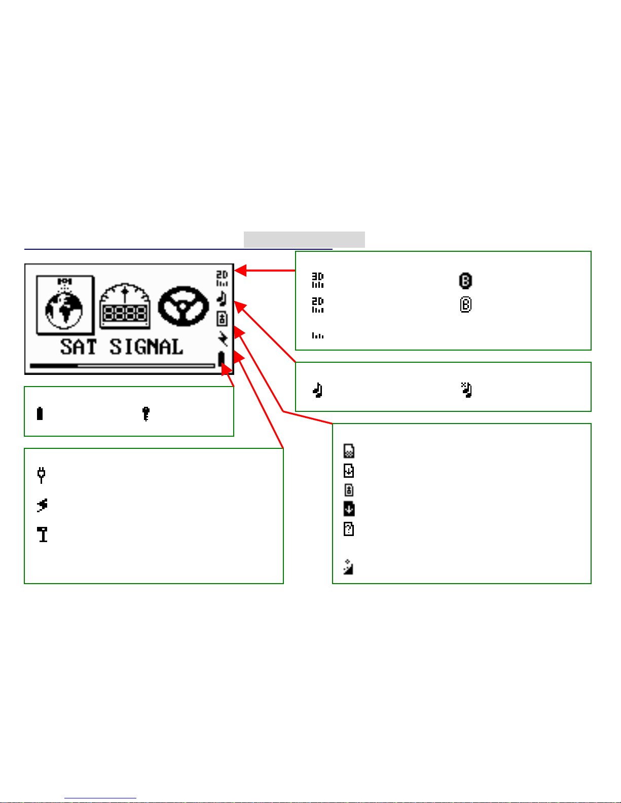
Status Indicators
Other Indicators
External Power: appears when USB
connected
Target Alert: appears when approaching
predefined waypoints
Over Speed: appears when speed
exceeds preset value
appears when altitude reaches the preset altitude.
Altitude Alert Indicator
card full, safe to remove card
card unknown or unformatted
card write-protected
Memory card Indicators:
card access in progress. Do not remove card.
card access stopped, safe to remove card
Position fix and Bluetooth Indicators
Positioning with 3D
fix(highlighted for DGPS fix) Bluetooth on
Positioning with 2D fix Bluetooth connected
Acquiring signal Available only on
BGT31
Audio Indicators
Enabled Disabled
Battery&Key Lock Indicators
Full Battery Key Locked
Pa
g
e S
y
stem Tree
Speed NavigationTrip Meter TrackSat Signal Position Mark
Sat signal
Sky View
Fixed Info
Odometer
Total Time
Trip MAX Speed
Trip AVG Speed
Trip Time
Trip Odometer
Time Now
Stop Watch
Speed(big font)
Altitude(big font)
Time Now
(big font)
Speed
MAX Speed
Nsecond MAX
AVG
Nsecond AVG
Speed
MAX/Nsecond
AVG Speed
Speed
VMG
AVG Speed
MAX Speed
Heading
Bearing
ODO Meter
Time Pass
Altitude
Departure
Arrival
Status
To NEXT
To DST
Time now
Sunrise
Sunset
10
Egg Laying
Mark
Interval
STOP
Distance
1 Second
5 Seconds
10 Seconds
30 Seconds
1 Minute
Clear
Save to Card
View
Mark
Go To
First (Point)
Last (Point)
Nearest Point
Detail
Egg Laying
Area (Calculation)
Settings
Speed
WPT Name
WPT Symbol
Edit and Save

Page System Tree (continued)
Memory
Card
Log Switch
Off/On/On-Fix
Min Speed
NMEA Items
GGA
GLL
GSA
GSV
RMC
VTG
ZDA
SBN
File Size
Card Size(max.2GB)
128KB
512KB
1024KB
2048KB
Format Card*
Remove Card*
*If card presented
Interval
Min Speed
Save to Card
Clear
AlertWaypoint Data
Lo
gg
er NAVILINK
List
Go To
Edit
Delete
Copy
Reverse
Rename
Area Calculation
New Route
Delete All
Route
Buzzer
On/Off
Over Speed Alert
Off/30-150KMH
Altitude Alert
Off/Above/Below
Target Alert
Waypoint type
Off/10M
~
1KM
Down/Upload
the data saved
on the built-in
flash memory
List
Go To
Delete
Edit
Copy
Type List
Del All
Save to Card
11

Page System Tree (continued)
MISCSettings
Language
Time Zone
Unit (of Measurement)
Time Format
Date Format
Time Zone
Arrived
Map Datum
Position (Format)
User Grid
Power Mode
DGPS Source
Interface
Backlight Time
Contrast
External Power Mode
BLUETOOTH*
BT SNIFF
User Name
Usage
Default&Reset
*BGT31 only
NAVILINK Port*
Speed AVG Time
Speed Genie
Hold Key
Serial No.
Version
Cold Start
Calendar
Reserved
12
Main Menu
Page Tree
Satellite Signal
Trip Meter
Speed
Navigation
Track
Position Mark
Waypoint
Route
Memory Card
Data Logger
Alert
NAVILINK
Settings
MISC
The courses you
plan to navigate
along
Satellite signal
and position fix
info
Provides the
information on
your movement
Navigating along
your waypoints or
routes
The current and
historical direction
of movement
Marking a location
for future reference
or for other uses
The database of
destination points Logging position an
speed data into SD
card (in NMEA or
SBN
)
Showing&managing
instant, average &
maximum speeds
(Speed Genie)
Logging position and
speed data into
internal flash memory
(in SBP format)
Setting up alarms Configuring the
system
Data exchange
with host PC
A
calendar up to
the year 2060
13
Satellite Signal
Page Tree
Sat Signal
Sky View
Fixed Info
GPS Signal
Satellite signal
strength bars.
A hollow signal
bar indicates the
corresponding
SAT is not used
for positioning.
The ID of the GPS
Satellites GPS in
view
SKY View
Satellite position. The two
circles indicate satellite
elevation as seen from
your current position
Satellite number being
seen
Satellite number being
tracked
PDOP - Position Dilution
of Precision. The lower
the better
GPS Fixed Info
Time in UTC
Date in UTC,
Heading
Velocity, Altitude
Current Location
Coordinates
(in DDMM.MMM)
14

Trip Mete
r
Altitude(big font)
(big font)
Time Now
Trip Time
Trip Odometer
Time Now
Time Now
Stop Watch
Speed(big font)
Total Time
Trip MAX Speed
Trip AVG Speed
Page Tree
Odometer
The Trip Meter pages provide Current Speed, Trip Timer, Average Speed, ODO Meter,
and more. All the meter pages have a similar format below.
Status Indicators
Speed Trend
2D or 3D fixed
Buzzer sound alert
SD/MMC card
External power
Battery status
Page title
Current speed
- Unit
Odometer
15

Average speed during
the trip - derived from
trip odometer and trip
time
Time elapsed
for the trip since
last trip reset
Accumulated
mileage during the
trip since last trip
reset
Total accumulated
operating time since
last reset
Current local time
([SETTINGS]/ [UTC]
must be set properly)
Current altitude
in big font
Maximum speed
during the trip since
last trip reset
Current local
Time in big font
Current speed
in big font
Press TS to reset,
pause or start
Stopwatch
Trip Mete
r
(continued)
Altitude(big font)
(big font)
Time Now
Speed(big font)
Trip MAX Speed
Trip AVG Speed
Trip Time
Trip Odometer
Time Now
Stop Watch
Page Tree
Odometer
Total Time
16

Speed
Continued to
next page
GT-31 will automatically switch to this screen if [SPEED GENIE]
threshold is set and the current speed is above it. Then if the current
speed goes below the threshold, GT-31 will switch to [MAX/NS MAX]
page to report the result. Refer to how to active speed genie for details.
MAX Speed
NS MAX AVG
NS AVG Speed
MAX/NS MAX
Time Now
Page Tree
Speed
Up to 14 history maximum speeds can be saved
automatically. The available commands:
RESET: zero the current max.speed
SAVE: save the current max.speed
if [SPEED GENIE] is off
RESTORE: display a max speed from history
and set it as the current max. speed
CLEAR: zero all history max. speeds.
Up to 10 history maximum average speeds can be
saved automatically. The available commands:
RESET: zero the current max.avg.speed
SAVE: save the current max.avg.speed
if [SPEED GENIE] is off
RESTORE: display max avg speed from history
and set it as current max.avg. speed
CLEAR: zero all history max.avg.speeds.
17

Display the current average speed for N-second (10S) time interval.
The time interval can be specified in [SETTINGS]/[SPEED AVG
TIME]
The value of [NS MAX AVG] page is the maximum value of
[NS AVG SPEED]
Speed (continued)
MAX/NS MAX
Time Now
NS AVG Speed
Page Tree
Speed
MAX Speed
NS MAX AVG
18
Navigation
The navigation pages provide the direction you are moving,
Page Tree
Speed
AVG Speed
MAX Speed
Heading
Bearing
ODO Meter
Time Pass
Altitude
Departure
Arrival
Status
To NEXT
To DST
Time now
Sunrise
Sunset
19
current time, speed, altitude and other trip computer information.
Compass
Distance to next
waypoint
Waypoint type
Current speed
Page title
Navigation features will be
activated only when a
route or waypoint has been
selected for navigation.
Otherwise the page will
show READY FOR NAV.
When the waypoint has
been reached, the arrival
message will be displayed
The distance for reaching
waypoint can be specified
in [SETTINGS]/[ARRIVED]
Pointer
Direction to be
navigated to
Next waypoint
Navigation (continued)
Page Tree
Speed
VGM
AVG Speed
MAX Speed
Heading
Bearing
ODO Meter
Time Pass
Altitude
Departure
Arrival
Status
To NEXT
To DST
Time now
Sunrise
Sunset
Large Compass
Velocity Made
Good (VMG)
The maximum
speed of this trip
The direction you
are traveling
The direction of
your destination
Accumulated
mileage
Current altitude
The average peed of
this navigation trip
The time of
departure
Total time elapsed
of this trip
Progress Info
Waypoints reached.
/Total waypoint
The time arrived at
the destination
Next waypoint info
Name
20 Distance
Other manuals for GT-31
2
This manual suits for next models
1
Table of contents
Other Locosys GPS manuals


Popular GPS manuals by other brands


Helm
Helm Downtime Operation manual

Prentke Romich Company
Prentke Romich Company NuEye user guide

Asus
Asus R600 - Auto Light Sensor PND quick start guide

Insignia
Insignia NS-NAV02R Quick setup guide

Honeywell
Honeywell Bendix/King KFC 225 pilot's guide

gtt systems
gtt systems GTTS-2000Bi Installation and user manual


