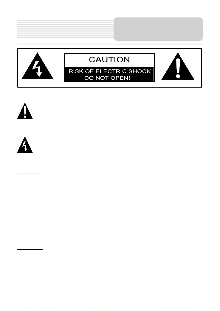
Prestigio RoadScout 3110 User manual

CAUTION
1. To reduce the risk of electric shock, do not remove the cover (or back). No
user-serviceable parts inside. Refer servicing to qualified service personnel. Unplug
the product from the wall outlet before servicing or when it is unused for a long
period of time.
2. The manufacturer should not hold responsibility for the damage caused by any
substitutions and modifications of the product without authorization from the
manufacturer or authorized unit.
3. Danger of explosion if battery is incorrectly replaced. Replace only with the same or
equivalent type.
WARNING
The apparatus shall not be exposed to dripping or splashing and that no objects filled
with liquids, such as vases, shall be placed on the apparatus.
The exclamation point within an equilateral triangle is intended to alert the
user to the presence of important operating and maintenance (servicing)
instructions in the literature accompanying the appliance.
The lightning flash with arrowhead symbol, within an equilateral triangle, is
intended to alert the user to the presence of un-insulated “dangerous
voltage” within the product’s enclosure that may be of sufficient magnitude to
constitute a risk of electric to persons.
Important Safety
Instructions

RoadScout 3110/4110/5110–Accessories List
ITEM
NAME
QTY
Car Charger
1
Mounting Cradle
1
USB Cable
1
Touch Pen
1
Leather Carrying Case
(GeoVision 5120 Only)
1
Driver/Documentation CD
1
User Manual
1
Warranty Card
Accessories
EN
EN - 1
1

Front and Side View
1. LCD Touch Screen
Tap the screen with touch pen or finger to select menu commands or to enter
information.
2. Battery Status Indicator
The indicator glows in bright amber color when battery is fully charged and in red
color when charging.
3. microSD Slot
Receives microSD memory card for data access or memory expansion.
4. Mini-USB Port
Connects to USB Cable for data access or battery charging
5. Headphone Port
Connects to stereo headphones or headsets.
6. Reset Button
Press to restore system to factory default settings.
7. Power Button
Press to power ON/OFF device.
8. Speaker
Emits sound, voice or music.
9. Touch Pen
Used for writing on the LCD Touch Screen.
10. Backlight Button
Press to illuminate the LCD.
View of Main Unit
1
2
4
5
3
6
7
8
9
10
EN - 2
EN

NOTE:
Please always make sure that the device and any other external device
connected to the device are powered off and unplugged from the power
supply before attempting to connect the device to any external device.
Inserting microSD Card
To insert a microSD card, place
connector towards device and card
label towards the front side of the
device.
To remove a microSD card, gently
press the edge of the card to release
the safety lock and pull the card out
of the slot.
NOTE:
Please always make sure that no application is accessing the microSD
card before extraction.
Charging
1. Connecting to External USB Device
Flip open the protective rubber cover towards the front of the device.
Insert USB connector into the appropriate USB port.
Insert the other USB connector into USB port on PC to start charging.
Device Connection

2. Connecting to Car Charger
Flip open the protective rubber cover towards the left side of the device.
Insert USB connector into the appropriate USB port.
Insert car charger connector into vehicle 5V accessory/cigarette socket to start
charging.
NOTE:
Please connect the car charger to vehicle 5V accessory/cigarette socket after
vehicle engine is started to protect the device from sudden surges in current.
Connecting to Earphones
Flip open the protective rubber cover towards the front of the device.
Insert earphone plug (not included) into the appropriate earphone port to switch
audio output from device speaker to earphone.
NOTE:
Excessively loud volume is potentially detrimental to hearing. Please turn
down the volume before connecting the earphone and gradually turn up
the volume to a comfortable level.
Device Connection

About Rechargeable Battery
The device is equipped with a built-in rechargeable battery. Please fully charge the
battery (for at least 8 hours) before initial use. The battery status indicator glows in red
color when charging and turns bright amber color when charging is complete. Charging
time is approximately 2 hours.
Working conditions and precautions for the rechargeable battery
Device with new batteries should be fully charged before initial use.
Battery should only be used and charged when temperatures are between 32~
100F.
It is not necessary to start charging the device before the battery is fully discharged.
NOTE:
Please connect the car charger to
vehicle 5V accessory/cigarette
socket after vehicle engine is started
to protect the device from sudden
surges in current.
Cautions on Battery
Charging
EN
EN - 3

NOTE:
Do not operate the device while driving.
Please select an appropriate location on the dashboard or
windshield where the device will not obstruct driver field of vision.
Device Mounting Procedures
The device can be securely mounted on vehicle dashboard or windshield with the
mounting cradle included. Please follow procedures below to operate mounting cradle:
1. Select an appropriate location on windshield or dashboard where the device and
mounting cradle will not obstruct driver field of vision.
2. Please also make sure that the device has a clear view of sky to attain best GPS
reception.
Place device on the bracket with
bottom positioned on the appropriate
socket.
Push on the top edge to securely
install device onto the cradle.
Lift the suction cup lever and press
the suction cup at desired location.
Press down the suction cup lever to
secure the mounting cradle on the
surface.
Rotate the knob to adjust device to
desired viewing angle.
To Dismount Device
1. Push the tap on top of the mounting cradle to release the device.
2. Lift the suction cup lever to easily remove the suction cup from windshield or
dashboard.
Using Mounting
EN - 4
EN

1. Press and hold Power Button
to turn on device.
2. Shortly after the greeting screen
is shown, the main menu will be
displayed.
3. Tap the corresponding buttons
with touch pen included to
navigate various functions.
4. Press and hold Power Button
to turn off the device or to allow
device to enter sleep mode.
Getting Started

Displays volume control
menu
Zooms in
Rotates map towards
surface
Zooms out
Rotates map towards
2D display
Starts GPS logging
Displays menu with
route or trip functions
Stops GPS logging
Displays compass
aligning to the direction
of device
Rotates map counter
clockwise
Displays main menu
Rotates map clockwise
Displays time; touch and
hold to switch to GPS
speed
Getting Started

1. displays main menu.
2. starts the search based on
given input.
3. Select the desired location from given
search results by taping the
appropriate entry from the list.
4. Selected location is shown on the
map.
5. If a desired location is chosen it can be
used for the route calculation
6. Navigate to sets location as
destination, calculates the route and
starts guidance
NOTE:
Guidance to location assumes calculation from current GPS position to
given destination. Current position is determined by GPS signal –GPS
signal availability is denoted by .
Navigation
EN - 5
EN

By choosing guidance item Navigate route is calculated and guidance is started.
Guidance window is shown below:
Displays next maneuver with real geometry of streets in enlarged
view. This window can be closed by touching little triangle in the
upper left corner
Distance to go
Estimated time of arrival
Time to go
Street/road/square name
after next maneuver
Shows the map with
current position in the
middle of the screen
Shows the map with
north position up
Shows the quality of GPS signal and battery status. Icon also
functions as the switch for window changing (guidance, tachometer,
and GPS signal summary window)
NOTE:
Display of last three fields is changed with the street/road/square name
display next on route. In order to stop the change field needs to be
touched. To resume the change field needs to be touched again.
Guidance
EN - 6
EN

Brightness of the screen can be adjusted for different lighting conditions - very bright
when the sun is shining or darker in the tunnels. Adjustment is done as follows:
Brings up main menu with possible actions. Find Settings on the
list.
Brings up lower part of the list of actions where Settings can be
found
Settings
Allows change of settings
Map
Brings up map display settings menu and choice of the map.
Screen Brightness
Adjustment

NOTE:
Guidance to location assumes calculation from current GPS position to
given destination. Current position is determined by GPS signal –GPS
signal availability is denoted by . In case of calculating the route
from other, non GPS position we use word TRIP instead of ROUTE (Trip
overview, Trip summary, Places along the trip, etc)
Route Overview
Shows the route on the map
Route Summary
Review of route data
Places along the route
Searches for POIs along the route
Drop next via point
Calculates the route by dropping next via point
Avoid next
Calculates the route by avoiding next 1, 2, 5, 10, or 20
KM on the existing route (in case of traffic jams or
constructions
Delete this route
Deletes the actual route
Via points list
List of via points. Allows optimization of the route using
traveling salesman algorithm
Maneuvers list
Gives the list of all maneuvers on the route
Route & vehicle types
Brings up route settings menu
Avoid road types
Calculate route by avoiding certain types of roads
Exclude road types
Excludes the road types
Save this route
Saves the route
Route Preview and
Editing

Changing Route Destination or Adding Via Points
To change route destination or add via
point:
1. Brings up main menu with
possible actions list. Choose search
method as needed –after acquiring
results choose appropriate route.
2. Brings up possible actions for
a chosen result
Search along the route (objective is most
commonly finding gas stations,
restaurants or accommodation is
performed as following:
1. Brings up main menu with
possible actions list. Choose search
method as needed –after acquiring
results choose appropriate route.
2. Places along the route: brings up
menu with POI categories list.
Touching a selected result displays
context menu. In this case Add as via
point should be selected.
Route Preview and
Editing
EN
EN - 7

Changing the Order of Via Points
If you need to recalculate route with existing parameters (via points and destination)
but with changed via points order, please do the following:
1. Brings up menu with the list of
possible tasks.
2. Deletes via point.
Moves via point up.
Moves via point down.
Optimize Stops Order (Via Points Order)
If you need to recalculate optimal route and wish to keep via points , it can be done
as following. During this operation starting point becomes finishing point.
First, define all needed parameters –starting point and via points/destinations. It can
be done by adding destinations in succession. In other words, chosen location is set
as starting point, another location is added as destination and by adding third
location as destination second location becomes via point. Route is calculated
automatically:
Route Preview and
Editing
EN - 8
EN

After all needed and chosen are set as
route parameters, and route is calculated,
route optimizing is done as following:
1. Brings up menu with the list of
possible tasks.
2. Choosing any point on route.
3. Brings up menu with possible tasks
and route optimizing.
4. Optimizing via points order
recalculates new route and keeps all
via points
NOTE:
Start point becomes finish point after the
operation is completed.
Route Preview and
Editing

Find Location
Find location
Brings up search menu. It is possible to search by
address, city only (city center), postal code, named
junction and longitude and latitude.
Special characters: it is not necessary to enter special
characters (č, đ, ž, ü, ö). Replace special characters
with (c, z, d, u, o)
Find Street address should be used for searches
when street and house number are known.
When searching address, two input fields
are offered, and if there is no text entered,
the content of them will be sample
city/town name in the first, and sample
street address (including sample street
number, if map contains street numbers)
in the second. This sample address
changes as current country is changed
(via flag button).
The ordering of the house number (before
or after the street name) suggested is the
ordering that is correct for the map of the
currently selected country. The user
should enter desired address in format
specific for the currently selected country
(if the user wants to search the house
number at all).
Once a letter is typed in any of the two
input fields, the sample data (grey) will
disappear.
Main Menu

If a house number does not appear in the
suggestion, the map data for the current
country most likely does not contain house
numbers data at all, so entering a house
number would be unnecessary.
The sample name of the city/town is also
provided when Find city center is used.
Find Place (POI)
Find place
Brings up menu for search of POIs. The whole or the
partial name of the POI user is interested in should be
entered. The search is performed for the selected
country regardless of the POI category, or its vicinity.
By clicking button, POIs will be
re-searched, this time based not only the
name, but the distance to current position
also.
Results obtain with criteria included
have distance to current position included,
and sorting button changes to , and
by clicking it the original search will be
performed again (the same mechanism is
applied for results of Find city center
search).
Main Menu
EN
EN - 9

POIs can also be searched near by
clicking at some point on map and
selecting Find nearest place.
The loaded dialog offers list that begins
with Find by name, and is followed by the
list of categories.
If some category is selected, all POIs of
that category that are near are selected
and displayed as search result.
If Find by name is selected, new input
dialog is shown where user can type name
of the POI that will be looked for in the
vicinity.
My Favorite Places
My favorite places
Displays the list of all locations saved as favorites. Any
location can be saved as favorite independently of the
location selection method. Add to favorites saves
selected location from search results into favorites.
Main Menu
EN - 10
EN

Initial sorting of results is „temporal“, i.e.
last recently added favorites are shown
first. By clicking button, they will be
sorted alphabetically, and the button will
change to button, meaning user can
choose to sort them by distance.
By clicking Sort by distance button, the
button changes to , meaning user
can sort result back to temporal order (and
distance to favorite is display in result list).
By selecting location on the list (touching
the item on the list), location is shown on
the map.
My Recent Destinations
Up to 99 most recent destinations are
saved in recent folder. Destinations are
saved automatically and can be retrieved
for later use (as starting points,
destinations, can be saved to favorites,
etc.). The same sorting buttons appear as
for the favorites.
Main Menu
This manual suits for next models
2
Table of contents
Other Prestigio Automobile Accessories manuals