Flymaster GPS SD User manual

User manual
Document version:1.0

All rights reserved. Except as expressly provided herein, no part of this manual may be
reproduced, copied, transmitted, disseminated, downloaded or stored in any storage medium,
for any purpose without the express prior written consent of Flymaster Avionics Lda. herein
Flymaster Avionics.
Flymaster Avionics hereby grants permission to download a copy of this manual onto a hard
drive or other electronic storage medium to be viewed and to print a copy of this manual or of
any revision hereto, provided that such electronic or printed copy of this manual must contain the
complete text of this copyright notice and provided further that any unauthorised commercial
distribution of this manual or any revision hereto is strictly prohibited.
Information in this document is subject to change without notice. Flymaster Avionics re-
serves the right to change or improve its products and to make changes in the content without
obligation to notify any person or organisation of such changes or improvements. Visit the
Flymaster Avionics website (www.ymaster-avionics.com) for current updates and supplemental
information concerning the use and operation of this and other Flymaster Avionics products.
Warning
It is the sole responsibility of the pilot to operate the aircraft in a safe manner,
maintain full surveillance of all ying conditions at all times, and not become distracted by
the Flymaster GPS SD . Flymaster Avionics is not responsible for any damages resulting from
incorrect or no data provided by the Flymaster GPS SD . Flight safety is the sole responsibility
of the pilot.
It is unsafe to operate the Flymaster GPS SD while in the air. Failure by the pilot equipped
with a Flymaster GPS SD to pay full attention to the aircraft and ying conditions while ying
could result in accident with property damage and/or personal injury.

Contents
Page
1 Getting Started 4
1.1 Charging the Battery .................................. 4
1.2 GPS SD Keys ...................................... 4
1.3 Using keys Inside Menu ................................ 5
1.4 Switching GPS SD On and O ............................ 5
1.5 Resetting the GPS SD ................................. 6
1.6 Setting the Volume ................................... 6
1.7 Flight Start and Recording .............................. 6
2 Flight Mode 7
3 GPS SD Elements 8
3.1 Graphical Elements ................................... 8
3.1.1 Battery ..................................... 8
3.1.2 Sound ...................................... 8
3.1.3
GPS
....................................... 9
3.1.4 Vario ...................................... 9
3.1.5 Navigation Circle ................................ 11
3.1.6 Airspaces Map ................................. 12
3.1.7 Altitude graph ................................. 14
3.1.8 Wind Arrow .................................. 14
3.1.9 Map Page .................................... 15
3.2 Data eld Elements ................................... 16
4 Menu mode 21
4.1 Waypoints and Route ................................. 22
4.1.1 Waypoints Actions Menu ........................... 23
4.1.2 RouteList .................................... 24
4.2 RouteNavigator ..................................... 25
4.3 Critical Airspaces .................................... 26
4.4 Nearby Landings .................................... 27
4.5 Flight Log ........................................ 27
4.6 Pages .......................................... 30
4.7 Settings Menu ...................................... 31
4.7.1 Set Altimeter .................................. 32
4.7.2 Time ....................................... 33
4.7.3 Vario Acoustics ................................. 33
4.7.4 Advanced Features ............................... 34
2

4.7.5 Trace ...................................... 36
4.7.6 Screen ...................................... 38
4.7.7 Language/Units ................................ 39
4.7.8 Device Settings ................................. 40
4.7.9 RF Probes ................................... 40
4.7.10 Probe Alerts .................................. 41
4.7.11 Polar ....................................... 42
4.7.12 FS Keys ..................................... 42
4.7.13 Airspace settings ................................ 43
4.7.14 GPS status ................................... 44
5 RouteDenition 46
5.1 Route Denition .................................... 46
5.2 Setting up the route .................................. 46
6 McCready Functions 47
7 Firmware 48
8 Interfacing with GPSDump 50
8.1 Conguring GPSDump ................................. 50
8.2 Uploading Waypoints .................................. 51
8.3 Downloading tracklogs ................................. 53
3

1 Getting Started
Fully charge battery before using your Flymaster for the rst time.
Figure 1.1: right view
The battery may be charged by either connecting the GPS SD USB connector to the wall socket charger,
or to a powered USB port using the USB cable. USB connector can be found on the right side of the GPS
SD (see gure 1.1).
1.1 Charging the Battery
Flymaster GPS SD has an advanced battery power management system, which gives the pilot accurate
information about the battery state, as well as the charging time and battery remaining time.
To charge the Flymaster GPS SD battery you may use the wall charger, the USB cable, or the car charger.
Original Flymaster accessories are recommended in order to avoid damage to the power management
system.
The Flymaster GPS SD has 2 charging modes, namely,
Quick Charge
and
Slow charge
. The charging mode
choice is automatic and based on the power source.
Quick charge
mode is activated when charging with
the wall charger or the car charger, while Slow Charge mode is activated when a USB cable connected to
a PC or MAC is used.
Charging, and battery status information is shown on both the power up screen and the
Shutdown
menu.
When the Flymaster GPS SD is connected to a power supply (wall charger or via USB cable), even with
the unit o, the instrument will show if it is being
Slow
or
Fast
charged. The time remaining to full charge
is also shown. This may not appear immediately when a power source is connected, since the instrument
requires some time to calculate the remaining charge time. A
Slow
charge is ok for topping up the battery
but not for fully charging. Use the wall or car charger to fully charge the instrument.
Note: The instrument will not charge when it is turned on and connected to a PC. The
instrument must be turned o in order to charge the battery using the PC USB port . This
behavior is deliberate to prevent overwhelming competition organizer's download hubs.
Note: Charging the instrument with high ambient temperatures should be avoided. Such
action can cause the battery to overheat and aect battery health.
1.2 GPS SD Keys
Four keys are used to interact with GPS SD (see Figure 1.2). In this manual we will call MENU key - S1,
ENTER key - S2, UP key - S3, and DOWN - S4. Each key has 2 functions depending whether the device
is in ight mode or in menu mode. Additionally the MENU key is used to
power-up
the GPS SD when it
is switched o.
4

Figure 1.2: GPS SD keypad
Note: If the active page includes a Map (Task Map, or Airspaces Map) FS Keys denition will
be ignored. In this case S3, and S4, will zoom in and out of the map whilst the S2 will switch
page.
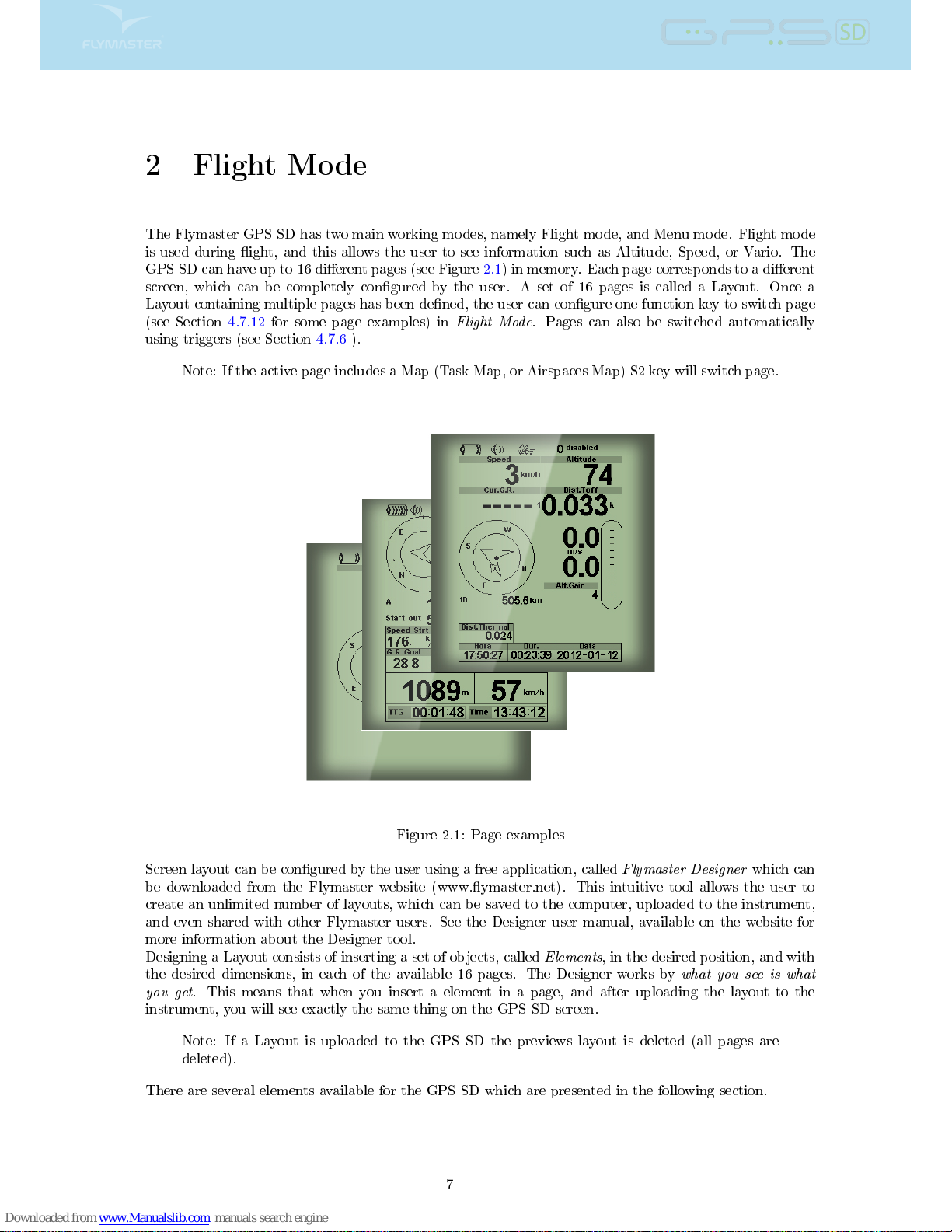
In menu mode all keys have xed functions shown by symbols on the keys namely S3=Move Up S4=Move
Down, S2=Enter and S1=Back(Exit).
1.3 Using keys Inside Menu
Changing parameters on the GPS SD can be performed through the menu. Changing a parameter involves
accessing the menu, selecting an option, and then changing a specic eld value. Accessing the main menu
can be done by pressing the MENU key in ight mode. Once in the menu, UP(S3), and DOWN(S4) keys
can be used to scroll up and down through the menu options list. During the scrolling process the selected
option is highlighted. The ENTER(S2) key should be used to access the option. Depending on the menu
option, a new menu options list, or a data elds list appears. In any time pressing the MENU(S1) key
takes you back. When accessing data elds the associated menu option becomes
grayed
and the respective
eld data item is highlighted. Using the UP and DOWN keys changes the value on each eld. Pushing
the ENTER key moves to the next eld, or in same cases to the next character/digit. Conversely, pushing
MENU key moves to the previous eld, or to the previews character/digit. If the ENTER key is pushed on
the last eld all the data in the selection section is stored and control returns to the conguration menu.
Inversely, if the MENU key is pushed on the rst data eld the changed settings are ignored and control
is returned to the conguration menu.
Tip: When setting a data eld that involves setting several characters, e.g. when dening
a waypoint name, after dening the desired characters, pushing the ENTER key continually
for more than 2 seconds will make the cursor jump to the next data eld, or return to the
conguration menu if no more data eld needs to be set.
1.4 Switching GPS SD On and O
To switch on the GPS SD , briey push the S1 key (Menu Key). This will display the start up screen with
a 10 second countdown . Pushing the S2 (Enter key) before the 10 seconds have elapsed will power up the
GPS SD . The GPS SD initiates in ight mode. If the S2 key is not pushed within 10 seconds the GPS
SD returns to sleep. To switch o the GPS SD , push the S1(menu key) to activate menu mode, then use
the S3 or S4 to select the
Shutdown
item, and nally push the S2 Key.
5

1.5 Resetting the GPS SD
The reset procedure allows the pilot to restart the GPS SD in the unlikely event that it freezes, or stops
responding (if this ever occur please report it to our support email). To reset the GPS SD push S1 (Menu)
key and the S4 (Down arrow) key, simultaneously, for at least two seconds. The display will go blank and
after will return in Flight mode.
Note: Resetting the GPS SD will also reset ight data, e.g. task status.
1.6 Setting the Volume
The GPS SD sound volume can be adjust using one FS Key, or trough the
Vario Accoustics
option of the
Settings
Menu (see Section 4.7.3). The GPS SD has six dierent sound levels, plus
no sound
. The current
volume level can be seen using the sound element (see Section 3.1.2 for more details).
Pressing the dened FS Key will scroll up the sound level until the maximum value. Pressing more will
mute the sound before start scrolling again starting from the minimum value.
Note: Changing the volume using an FS key is only valid for the current ight, and will not
override the volume level setting. Every time the instrument is turned on, if the sound is
muted, an alarm is generated in order to notify the pilot.
Note: When the instrument is turned on the sound can be muted despite the volume level
settings. This occurs due to the
Auto silent
mode is activated (see Section 4.7.4 for more
details)
1.7 Flight Start and Recording
Most of the GPS SD features are only available after the
Flight Start
. This procedure is taken in order to
avoid wrong calculations due to missing data. Flight starts when all of there 3 conditions are met:
1. GPS 3d x is established;
2. Speed goes over the congured
Start Speed
(default value is 8km/h)
3. Average vario is greater than +-0.15m/s
6

2 Flight Mode
The Flymaster GPS SD has two main working modes, namely Flight mode, and Menu mode. Flight mode
is used during ight, and this allows the user to see information such as Altitude, Speed, or Vario. The
GPS SD can have up to 16 dierent pages (see Figure 2.1) in memory. Each page corresponds to a dierent
screen, which can be completely congured by the user. A set of 16 pages is called a Layout. Once a
Layout containing multiple pages has been dened, the user can congure one function key to switch page
(see Section 4.7.12 for some page examples) in
Flight Mode
. Pages can also be switched automatically
using triggers (see Section 4.7.6 ).
Note: If the active page includes a Map (Task Map, or Airspaces Map) S2 key will switch page.
Figure 2.1: Page examples
Screen layout can be congured by the user using a free application, called
Flymaster Designer
which can
be downloaded from the Flymaster website (www.ymaster.net). This intuitive tool allows the user to
create an unlimited number of layouts, which can be saved to the computer, uploaded to the instrument,
and even shared with other Flymaster users. See the Designer user manual, available on the website for
more information about the Designer tool.
Designing a Layout consists of inserting a set of objects, called
Elements
, in the desired position, and with
the desired dimensions, in each of the available 16 pages. The Designer works by
what you see is what
you get
. This means that when you insert a element in a page, and after uploading the layout to the
instrument, you will see exactly the same thing on the GPS SD screen.
Note: If a Layout is uploaded to the GPS SD the previews layout is deleted (all pages are
deleted).
There are several elements available for the GPS SD which are presented in the following section.
7

3 GPS SD Elements
The main objective of an element is to provide information to the user. Elements can be Graphical, or
Data Field type. Each element has its own properties which can be changed in order to alter the element
behaviour, and/or shape.
3.1 Graphical Elements
Graphical elements are characterized by providing information in a graphical way. Most of the graphical
elements have xed dimensions, although their position can be altered.
As the GPS SD rmware evolves the list of Graphical Elements will likely grow. The current list includes
the following graphical elements.
3.1.1 Battery
The Battery Element provides a graphical indication of the current battery level. In Table 3.1 it is possible
to see the relationship between what is shown and the actual battery level in percentage. This element
has xed dimensions.
Table 3.1: Battery Element description
Symbol Description
Battery level above 90%
Battery level between 70% and 89%
Battery level between 50% and 69%
Battery level between 30% and 49%
Battery level between 15% and 29%
Less than 15% battery remaining
3.1.2 Sound
The Sound Element provides graphical representation on the current volume level. Table 3.2 Shows the
relationship between what is shown and the sound level. This element has xed dimensions.
Table 3.2: Sound Element description
Symbol Description
Sound Level 6 (maximum sound level)
Sound Level 5
Sound Level 4
Sound Level 3
Sound Level 2
Sound Level 1
Sound is muted (No sound)
8

3.1.3
GPS
The
GPS
Element provides graphical indication about the current
GPS
signal quality. Basically, the
lower the PDOP value (position dilution of precision), the more accurate calculations are for determining
position. Values bellow 3.0 are fairly accurate. The relationship between what is shown and the signal
quality can be seen in Table 3.3. Note that FAI rules require 3D tracklog data, which includes
GPS altitude
.
Table 3.3: GPS signal quality
Symbol Description
3D position with a PDOP bellow 1.5
3D position with a PDOP between than 1.5 and 2.0
3D position with a PDOP between than 2.0 and 3.0
3D position with a PDOP greater than 3.0
2D position (no altitude information)
No GPS Signal
Therefore the GPS SD will only start recording a tracklog when 3D information is available. The GPS
SD has an high sensitivity 50 channel GPS receiver which oers unmatched tracking performance in harsh
signal environments (-160 dBm sensitivity), and very short acquisition times. The GPS SD has a 4 Hz GPS
update rate (most of others only provide 1Hz) which allows the GPS SD pilot to see very small speed and
position changes. Furthermore, the movement of the direction arrow is smoother and any position change
is shown in a quarter of the time of other devices. Note that the 4 Hz update rate requires more than 5
satellites in view. More information about
GPS
accuracy and also other
GPS
related information can be
seen in (
http://en.wikipedia.org/wiki/Error_analysis_for_the_Global_Positioning_System
).
3.1.4 Vario
The Analog Vario Elements shows information regarding the analogue instantaneous vertical speed. There
are four dierent Elements that can be used to display the vario. All of these element can be resized and
re-positioned.
Analog Vario
This Element which can be resized and repositioned, graphically represents the rate of climb, scaled from
0 m/s to +/-10 m/s depending if you are climbing or sinking Figure 3.1.
Figure 3.1: Analog Vario
When the GPS SD detects that the pilot is climbing, a black bar starts to grow on the left, from the
bottom of the scale to the top ,with 0.1 m/s increments. The same bar grows on the right, from the top
of the scale to the bottom, if sinking is detected.
9

Big Analog Vario
The
Big Analog Vario
element shows the instantaneous vertical speed (Figure 3.2). This element can be
resized and re-positioned.
Figure 3.2: Big Analog Vario
This Element graphically represents the rate of climb, scaled from 0 m/s to +/-10 m/s depending if you
are climbing or sinking. In this Element a black bar starts from the middle of the scale and grows at 0.1
m/s increments, up to 5 m/s at the top of the scale. When 5 m/s value is reached the black bar starts to
disappear from 0 m/s (middle of the scale) until the top of the scale. When the bar completely disappears
the climbing rate is equal, or above 10 m/s. The same process occurs when descending, but from the
middle of the scale to the bottom.
Double Bar Analog Vario and McCready Indicator
The Double Bar Analog Vario element shows not only the instantaneous vertical speed, but also the
Average Thermal
and
Next Expected Thermal
(McCready Indicator) (see Figure 3.3). This element can
be resized and re-positioned. The element consists of 4 columns. In the left most column a black bar is
shown which indicates the average thermal climb rate. This value is always positive. In the next column
a double arrow is shown which indicates the next expected thermal climb rate. Finally, the last columns
show 2 bars indicating the climb rate and the sink rate. See more about the McCready indicator in
Chapter 6.
Figure 3.3: Double Bar Vario and McCready Indicator
Dial Analog Vario
The Dial Analogue Vario element shows the instantaneous vertical speed (Figure 3.4). This element can
be resized and re-positioned. Climb or sink rates are shown by the position of the needle on the analogue
dial. The maximum and minimum climb rates can be set using the DESIGNER software.
10

Figure 3.4: Dial Vario
3.1.5 Navigation Circle
The Navigation Element is a multi-information element which shows graphically the bearing, wind direction
and thermal core. Additionally, if a destination was dened (waypoint) the navigation element will also
indicates the direction to the waypoint center, the waypoint edge and the direction to the waypoint after
the next one. This element cannot be resized but can be re-positioned. For navigation information to be
displayed the GPS SD the
Start Fligth
conditions must be met (see Section 4.7.4).
Figure 3.5: Navigation Element
Navigation information is shown within the inner most circles. The external circle contains the cardinal
points and the Wind Flag. The current traveling direction (bearing) corresponds to the point indicated in
the top of the navigation circle. On the example shown in Figure 3.5, the bearing is approximately 80
º
.
Navigation Arrows
. If no route is dened the arrow will start showing the direction to the takeo, after the takeo is detected
(TakeO is the point taken when the Flight Starts)
Figure 3.6: Route Optimisation
When a route is active the
direction of next waypoint
(WP1) is pointed by an arrow (larger arrow 1). If
no route is dened the arrow will start showing the direction to the takeo, after the takeo is detected
11

(TakeO is the point taken when the Flight Starts). Small course corrections are sometimes required and
these are shown on the GPS SD by a
ne adjustment indicator
in the form of a small arrow 4. Arrow 4
to the left means the pilot should turn slightly to the left, and inversely arrow 4 to the right indicates a
small adjustment to the right is needed.
When the course is perfect, i.e. less than 1
º
o, the GPS SD indicates this by showing a large arrow
forward (Figure 3.7).
Figure 3.7: Perfect Heading
Thermal Core Map
Another useful feature of the Navigation Circle Element is the thermal core map. This map corresponds to
a black dot which is shown inside the inner navigation wheel (together with the navigation arrows).During
a thermal climb the GPS SD keeps track of the strongest climb values point for each 50m layer. The
point of strongest lift is then graphically represented by the black ball in the inner Navigation Circle,
showing where the thermal core is relative to the pilot's position. The position of the dot (thermal core)
is constantly updated as the pilot moves. When the pilot is over 300m from the thermal core the dot will
be at the edge of the circle. As the pilot moves closer to the thermal core the dot will move towards the
center.
Figure 3.8: Thermap Core Map
In Figure 3.8 the thermal core is currently behind the pilot at a distance of approximately 150 meters
(half of 300 m wheel radius).
Wind Flag
The external circle contains a small ag which indicates the Wind Direction relative to the pilot direction
(
direction the wind is coming from
). For example, if the pilot is facing the wind then the ag is on the
top of the circle. In the example of (Figure 3.5) the wind is blowing from Northeast.
3.1.6 Airspaces Map
The
Airspaces Map
element provides information to the user relative to specic three-dimensional objects,
previously loaded to the instrument. Each of this objects can be an airspace volume. Airspace information
can loaded to the instrument using the Flymaster Designer software (see Designer user manual for more
information). The GPS SD only accepts data in the
OpenAir
format, and it has a limitation of 12000
polygons points. (See
http://www.gdal.org/ogr/drv_openair.html
for more information about the
open air format).
12

Figure 3.9: Airspace Element
When the element of Figure 3.9 is inserted in a layout using DESIGNER, a 2D map (box) is shown on
the instrument (see Figure 3.10). On the bottom left of the map the scale is indicated in Km, and on the
centre of the map is an arrow. This arrow represents the pilot position, and its orientation indicates the
bearing of the movement. The map is always oriented
North Up
.
Note: When new Airspaces data is uploaded to the GPS SD using DESIGNER the previews
data is deleted. If a empty Airspaces data le is uploaded then all the Airspaces will be deleted.
The rst time the map is drawn, it is centred on the last GPS position the GPS SD has in its memory.
The map is re-centred once the ight starts i.e. when a valid gps signal exists, and the
start speed
(see
Section 4.7.4) is reached.
Note: After new Airspace data is uploaded to the GPS SD it can only be seen on the Map
after the
Flight Starts
.
Once the ight starts, the map is redrawn with an arrow (representing the pilot) which will move around
the map, indicating the relative position of the pilot to each of the airspace areas. If the pilot is outside
a visible airspace area then a gray line is used to draw the area, whereas if the pilot is inside the airspace
then a black line is used instead. Note that being inside a airspace area (2D) does not mean that the
airspace is being violated, since the pilot can be above, or below the dened 3D shape. In order to have
more information about possible airspaceÂs violation, some data elds should be added to the layout.
This data elds are Distance to CTR, Altitude to CTR, and CTR Status (Figure 3.10).
The Dist. CTR data eld shows the shortest horizontal distance to the nearest airspace line. This distance
is always positive. Similarly, the
Alt. To CTR
shows the shortest vertical distance to nearest airspace line.
Unlike the horizontal distance, the vertical distance can be negative. A positive vertical distance indicates
that you are outside the airspace, whereas a negative distance indicates that you are inside the airspace.
Additionally, the
CTR status
eld will indicate if an airspace is being violated by displaying
Violating
.
If the pilot is not violating the airspace but it is inside a predened margin then the messages
Altitude
Imminent
, or
Position Imminent
will be shown.
Figure 3.10: Airspace Map and Associated Data Fields
When the page contains an airspace map element, the UP, and DOWN keys, can be used to change the
map scale: pressing the UP key will decrease the scale, and the DOWN key will increase the scale. The
corresponding
user dened key function
will be disabled.
13

3.1.7 Altitude graph
The Altitude graph element (Figure 3.11) corresponds to a graph of barometric altitude versus time.
Altitude is shown in the vertical axis graduated in meters with time shown on the horizontal axis graduated
in seconds.
Figure 3.11: Altitude Graph Element
The range of the horizontal axis is xed and corresponds to 240 seconds (4 minutes), while the range of the
vertical axis is automatically adjusted in order to accommodate the gained height. In reality the altitude
graph element is a plot of the absolute barometric altitude over the last 4 minutes of ight (Figure 3.12).
Figure 3.12: Altitude Plot
3.1.8 Wind Arrow
The
Wind Arrow
element (Figure 3.13) is a re-sizable graphical element.
Figure 3.13: Wind Arrow Element
When used in a layout an arrow is draw showing the wind direction relative to the pilot direction (
direction
the wind is coming from
). For example, if the pilot is facing the wind then the arrow points south (bottom
of the screen). Centered over the arrow is a circle in which a number is displayed showing the wind speed
in Km/h (Figure 3.14). In the example of (Figure 3.14) the wind is blowing from East. Both, the wind
speed, and direction, value can be seen in a data elds.
14

Figure 3.14: Wind Arrow
Note that both wind direction, and speed, are calculated based on the GPS ground speed while the pilot
is turning, so there is no need of wind speed probe. The wind speed calculation accuracy increases with
the number of turns made.
3.1.9 Map Page
The MAP element (Figure 3.15) provides information to the user about their position relative to waypoints,
cylinder edges and the pilot's trace or track. This element can be resized and moved around the screen.
Figure 3.15: Map Element
A typical map page in ight may look like Figure. 20. In this gure is shown the scale on the bottom left.
The scale can be manually changed by pressing the F1 button to enlarge the map and therefore reduce
the scale, and conversely by pressing the F2 button to reduce the map and therefore increase the scale.
Figure 3.16: Map Page
If ying a competition route, the optimized route is drawn between the turnpoint cylinders. The position
of the pilot is indicated by the arrow and the trace for the last approximately 4 mins of the ight is shown.
Traces older than 4 mins are erased to reduce clutter on the screen.
15

3.2 Data eld Elements
Data eld elements can be used to shown numerical information like altitude, vertical speed, speed, glide
ratio, and many others.
These elements have congurable size, and position, although the text within has only 3 possible sizes.
The folowing table explains the available data elds. As the GPS SD rmware evolves this list will likely
grow. +
Table 3.4: Data elds Description
Field ID Description
VMG Velocity made good, is the speed at which the pilot is approaching
the active turn point.
Longitude Current position longitude according to the format dened in the
settings menu.
SpeedToFly Optimal Speed to Fly value calculated according the McCready
Theory. The True Air Speed value is calculated based on the
dened polar and the average thermal speed.
McRdyNxtThrm Next thermal expected average speed calculated based on the Mc-
Cready Theory. Considering the dened polar it calculates the
speed next thermal should have if you are ying at a certain mea-
sured True Air Speed (TAS Probe needed). This value is related
with the Speed to Fly and is shown graphically in the Double Bar
Vario.
Latitude Current position latitude according to the format dened in the
settings menu.
Ceiling Shows the upper altitude of the airspace causing the warning, i.e.
airspace that you are violating or close to violating.
Floor Shows the lower altitude of the airspace causing the warning, i.e.
airspace that you are violating or close to violating.
Time Current local Time. This value is automatic revised when the
device gets a valid Gps Signal. (see Note 2)
Dur. Flight Duration. Duration of the current ight.
Date Current date. This value is automatic set when the device gets a
valid GPS Signal
G.R.Next Glide Ratio to Next. Necessary glide ratio to reach the next turn
point.
Cur.G.R. Current glide ratio calculated using the average vario value, and
average ground speed.
G.R.M.G. Glide ratio made good. The actual glide ratio towards the active
turn point. It is calculated using the integrated vario, and the
VMG.
Trans.G.R. Glide ratio during transition. Average glide ratio during transi-
tions between thermals.
Alt.Gain Altitude Gain. Altitude gained in current thermal.
Alt.Gain/Loss Altitude Gain/Loss. When at the top of the thermal displays the
altitude gained from the base of the thermal, else displays the
altitude lost since reaching the top of thermal.
Therm.Dur. Time pilot has spent in the most recent thermal.
Thrml.Perfo. Perfomance of the most recent thermal showing average rate of
climb in most recent thermal.
Dist.Next Distance to Next. Shortest distance to the waypoint center. Dis-
tance next corresponds to the Distance Line plus the waypoint
radius.
Active waypoint Active turnpoint name. Continued on next page
16

Table 3.4 continued from previous page
Field ID Description
Thermal top The highest point reached during the current thermal.
Max.Alti Maximum altitude reached during current ight. This is based on
barometric altitude.
GPS Alti Altitude reported by the GPS.
Flight Level Current altitude in hundreds of feet, based on a xed QNH of
1013.25hPa.
Altitude Current altitude. This altitude is calculated based on the baro-
metric pressure and depends on the QNH value.
Altitude2 Second Altimeter which can be set independently to the main
altimeter.
MotorTemp Motor Temperature (available when connected with Flymaster
M1).
RPM Motor revolutions per minute (available when connected with Fly-
master M1).
Fuel Fuel level in liters (available when connected with Flymaster M1).
Arrival Next Estimated arrival height above the next waypoint. This means
that wind, day quality and glider performance are used in the
calculations.
Dist.To Distance to take o is the distance between the current point and
the ight starting point.
Dist.Thermal Shortest distance to last thermal core (thermal dot).
Dist.CTR Distance to controlled airspace. When more than one airspace
area is in range the closest will be shown. When inside an airspace
area the distance shown is to the closest edge.
Alt.to CTR Altitude to CTR shows altitude to controller airspace, a negative
number indicates we must sink to come out of controlled airspace.
CTR Status Status message of airspace, will show
Violating
when in controlled
airspace,
Immenent Alt
when close to entering airspace vertically
or
Pos.Immenent
when close to entering airspace horizontally.
CTR Name Name of the airspace causing warning or violation.
Abs.Pressure Absolute atmospheric pressure value in Pascals.
Max.Climb Once a ight has started, it shows the maximum rate of climb
encountered during the ight. This value uses the integrated vario
not the instantaneous rate of climb. This provides good indication
of the quality of the day's thermals. This value is reset when the
instrument is switched o.
Max.Sink Once a ight has started shows the maximum sink encountered
during the ight. Note that these values are using the integrated
vario. When the instrument is switched o this value is reset back
to zero.
Vario Instant vario value.
Ave.Vario Average Vario calculated using an integration time constant in
order to indicate smoother climbing rates.
Speed Indicates ground speed. The speed is only available when the GPS
receiver has a valid signal.
Max.Speed Maximum Speed (returned by GPS) reached during the ight.
When the instrument is switched o this value is reset back to
zero.
Ave.Speed Average ground speed calculated using a lter to show a smoothed
speed, eliminating erratic speed changes due to glider pitching,
etc.
Heading Heading in degrees returned by GPS.
Bearing Current bearing in degrees.
AveROT Average rate of turn in degrees per second.
Continued on next page
17

Table 3.4 continued from previous page
Field ID Description
Wind Speed Calculated wind speed using gps speed.
Wind Dir. Wind direction in degrees, calculated from gps when drifting.
Above To Altitude above takeo is the altitude over the ight starting point.
G.R.To Glide ratio to takeo. Necessary glide ratio to reach the take o.
Page Num. Current layout active page number.
Battery Shows battery strength as a percentage of complete charge
Voltage Current battery level in Volts.
Int.Temperature Temperature inside the instrument.
Pulse Current heartbeat in beats per minute, when using the Flymaster
Heart-G sensor.
Steps/Min Cadence showing number of steps per minute.
Steps Number of steps taken since counting initiated.
G-Force Current G-Force being experienced by the pilot when using the
Heart-G sensor.
AirTemp. Air Temperature as measured by the wireless speed probe.
TAS True Air Speed. This information is available when the instrument
is used in conjunction with the Flymaster TAS pitot probe.
Table 3.5: Data elds Description
Field ID Description
VMG Velocity made good, is the speed at which the pilot is approaching
the active turn point.
Longitude Current position longitude according to the format dened in the
settings menu.
SpeedToFly Optimal Speed to Fly value calculated according the McCready
Theory. The True Air Speed value is calculated based on the
dened polar and the average thermal speed.
McRdyNxtThrm Next thermal expected average speed calculated based on the Mc-
Cready Theory. Considering the dened polar it calculates the
speed next thermal should have if you are ying at a certain mea-
sured True Air Speed (TAS Probe needed). This value is related
with the Speed to Fly and is shown graphically in the Double Bar
Vario.
Latitude Current position latitude according to the format dened in the
settings menu.
Ceiling Shows the upper altitude of the airspace causing the warning, i.e.
airspace that you are violating or close to violating.
Floor Shows the lower altitude of the airspace causing the warning, i.e.
airspace that you are violating or close to violating.
Time Current local Time. This value is automatic revised when the
device gets a valid Gps Signal. (see Note 2)
Dur. Flight Duration. Duration of the current ight.
Date Current date. This value is automatic set when the device gets a
valid GPS Signal
G.R.Next Glide Ratio to Next. Necessary glide ratio to reach the next turn
point.
Cur.G.R. Current glide ratio calculated using the average vario value, and
average ground speed.
G.R.M.G. Glide ratio made good. The actual glide ratio towards the active
turn point. It is calculated using the integrated vario, and the
VMG. Continued on next page
18

Table 3.5 continued from previous page
Field ID Description
Trans.G.R. Glide ratio during transition. Average glide ratio during transi-
tions between thermals.
Alt.Gain Altitude Gain. Altitude gained in current thermal.
Alt.Gain/Loss Altitude Gain/Loss. When at the top of the thermal displays the
altitude gained from the base of the thermal, else displays the
altitude lost since reaching the top of thermal.
Therm.Dur. Time pilot has spent in the most recent thermal.
Thrml.Perfo. Perfomance of the most recent thermal showing average rate of
climb in most recent thermal.
Dist.Next Distance to Next. Shortest distance to the waypoint center. Dis-
tance next corresponds to the Distance Line plus the waypoint
radius.
Active waypoint Active turnpoint name.
Thermal top The highest point reached during the current thermal.
Max.Alti Maximum altitude reached during current ight. This is based on
barometric altitude.
GPS Alti Altitude reported by the GPS.
Flight Level Current altitude in hundreds of feet, based on a xed QNH of
1013.25hPa.
Altitude Current altitude. This altitude is calculated based on the baro-
metric pressure and depends on the QNH value.
Altitude2 Second Altimeter which can be set independently to the main
altimeter.
MotorTemp Motor Temperature (available when connected with Flymaster
M1).
RPM Motor revolutions per minute (available when connected with Fly-
master M1).
Fuel Fuel level in liters (available when connected with Flymaster M1).
Arrival Next Estimated arrival height above the next waypoint. This means
that wind, day quality and glider performance are used in the
calculations.
Dist.To Distance to take o is the distance between the current point and
the ight starting point.
Dist.Thermal Shortest distance to last thermal core (thermal dot).
Dist.CTR Distance to controlled airspace. When more than one airspace
area is in range the closest will be shown. When inside an airspace
area the distance shown is to the closest edge.
Alt.to CTR Altitude to CTR shows altitude to controller airspace, a negative
number indicates we must sink to come out of controlled airspace.
CTR Status Status message of airspace, will show
Violating
when in controlled
airspace,
Immenent Alt
when close to entering airspace vertically
or
Pos.Immenent
when close to entering airspace horizontally.
CTR Name Name of the airspace causing warning or violation.
Abs.Pressure Absolute atmospheric pressure value in Pascals.
Max.Climb Once a ight has started, it shows the maximum rate of climb
encountered during the ight. This value uses the integrated vario
not the instantaneous rate of climb. This provides good indication
of the quality of the day's thermals. This value is reset when the
instrument is switched o.
Max.Sink Once a ight has started shows the maximum sink encountered
during the ight. Note that these values are using the integrated
vario. When the instrument is switched o this value is reset back
to zero.
Vario Instant vario value. Continued on next page
19
Table of contents
Other Flymaster GPS manuals

Flymaster
Flymaster LIVE SD User manual

Flymaster
Flymaster Nav SD User manual

Flymaster
Flymaster SD Series User manual

Flymaster
Flymaster LIVE SD User manual

Flymaster
Flymaster GPS LS User manual

Flymaster
Flymaster Vario User manual

Flymaster
Flymaster Vario SD User manual

Flymaster
Flymaster N Series User manual

Flymaster
Flymaster NAV User manual

Flymaster
Flymaster F1 User manual