NovaSail NS-START POCKET V2 User manual

Operating Manual
v1.0

2
Introduction. . . . . . . . . . . . . . . . . . . . . . . . . . . . . . . . . . . . . . . . . .3
Installation. . . . . . . . . . . . . . . . . . . . . . . . . . . . . . . . . . . . . . . . . . .4
Controls and display description . . . . . . . . . . . . . . . . . . . . . . . .5
Screens and modes . . . . . . . . . . . . . . . . . . . . . . . . . . . . . . . . . . .5
Operations. . . . . . . . . . . . . . . . . . . . . . . . . . . . . . . . . . . . . . . . . . 6
• Switching power on and off.............................................. 6
• Switching backlight on and off ......................................... 8
• Run screen ...................................................................... 8
• Start screen, timer ........................................................... 8
• Start screen, start line distance .......................................
• GPS data logger .............................................................11
• Current GPS coordinates ...............................................11
• Max speed and average speed ......................................11
Advanced operations . . . . . . . . . . . . . . . . . . . . . . . . . . . . . . . . . . . . 12
• SET mode...................................................................... 12
• PC mode........................................................................ 16
imited Warranty . . . . . . . . . . . . . . . . . . . . . . . . . . . . . . . . . . . 19
Disclaimer . . . . . . . . . . . . . . . . . . . . . . . . . . . . . . . . . . . . . . . . .20
Contents
3
Welcome to the
The has been designed to provide essential
information with a very simple and user friendly interface. Speed, heading, timer,
start line distance and GPS coordinates functions are all accessible at the push of
a button and clearly displayed on the backlit LCD, ideal for night sailing and
enhanced safety.
The new V2 version has an upgraded button panel and an LCD mounted on a soft
silicon pad to withstand the toughest environment. It features also a Bluetooth
communication transceiver offering a wide range of functions and applications:
•
Record up to 1248 hours of racing (1 point / 30 seconds)
•
Replay on Google Earth and other navigational software
•
Updates with new features
Compact (125 mm x 80 mm x 26 mm) and intuitive, the
is a light, portable device, which is completely
waterproof, ultra robust, made of bombproof polycarbonate and stainless steel. It
features an upgraded button panel and LCD mounted on a soft silicon pad to
sustain the toughest environment.
Powered by only one AA battery, the gives sailors
accurate information for over 30 hours. It can be installed in minutes and there is
no need to drill a hole in the hull or use a wired connection.
We hope you enjoy sailing with the . We encourage
you to read this manual thoroughly to learn about the many features of your
exciting new NOVASAIL product.
Introduction

4
Wherever you mount the , it shouldn’t be flush to
any thick surface such as the hull, so that the sensitivity of the embedded GPS
receiver is not affected. Also a direct mount on a metal surface will reduce the
receiver sensitivity.
Installation
5
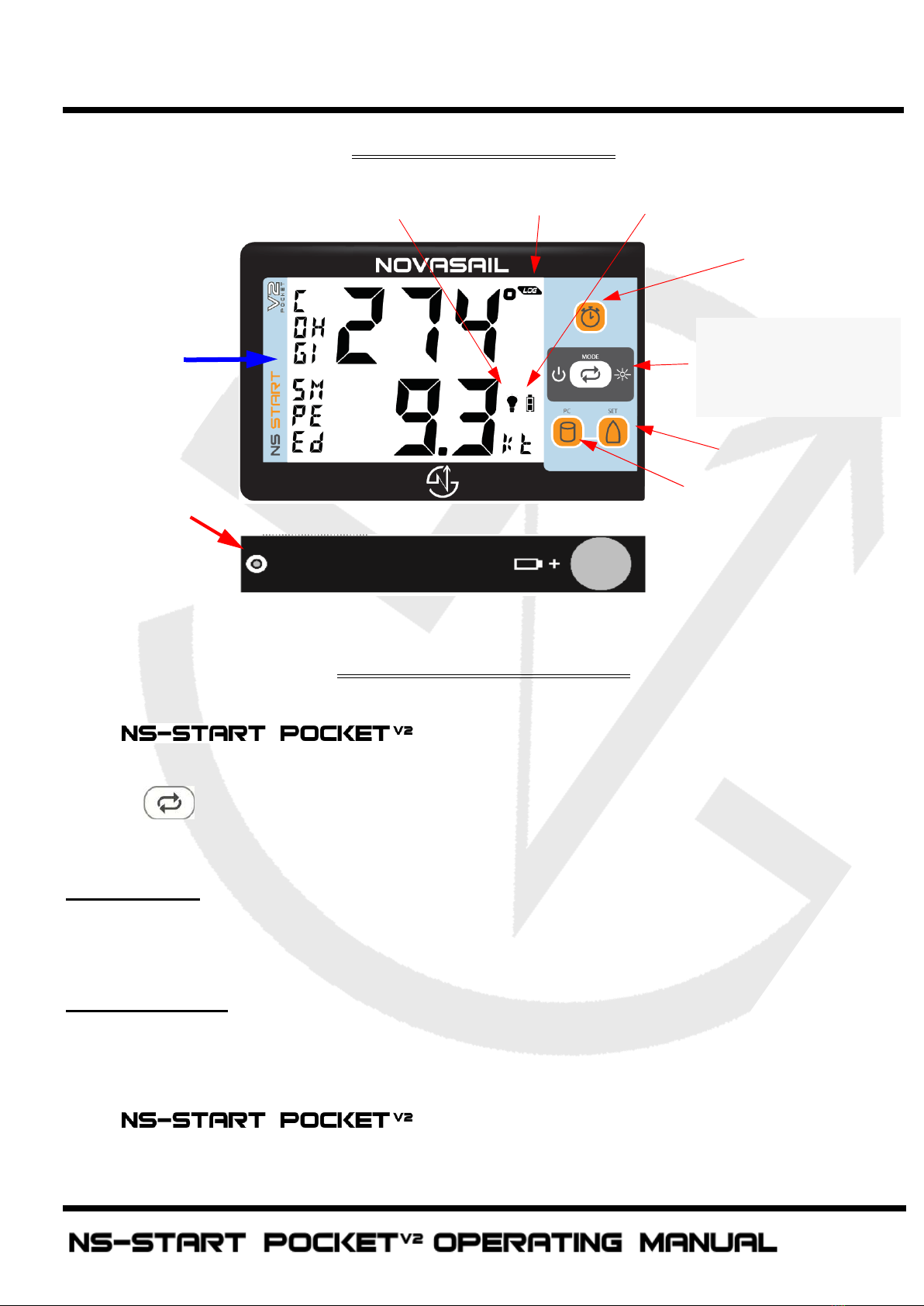
Buttons & display
Screens and modes
The has 2 main modes of operation : the RUN
screen and the START screen. Switching screens is made by pressing the
button .
RUN Screen
Course Over Ground- GPS Compass: COG
Speed Over Ground: SPE
START Screen
Timer: TIM
Start Line Distance: S D
The has 1 information screen.The GPS
coordinates and the average/max instant speed recorded during the current trip
Power ON/OFF
Backlight ON/OFF
RUN/START screen
mode selection
Pin
Boat
Timer
Battery level
Backlight
GPS record status
Screen
mode
display
Safety leash to
pass through
this hole
Controls and display description
Table of contents
Other NovaSail Marine GPS System manuals


Popular Marine GPS System manuals by other brands

Airmar Technology Corporation
Airmar Technology Corporation GH2183 Owner's guide and installation instructions

JRC
JRC JHS-183 installation manual

Thuraya
Thuraya IP Voyager user guide

Furuno
Furuno GP-1610CF Operator's manual

Raytheon
Raytheon NautoPilot NP 5100 Operator's manual

Furuno
Furuno GP-1650WDF Operator's manual


Raymarine
Raymarine G-Series system Installation & commissioning instructions

Radio Zeeland DMP
Radio Zeeland DMP Sigma 120 manual

Addvalue Innovation
Addvalue Innovation wideye SABRE RANGER 5000 quick start guide

Garmin
Garmin GPSMAP 190-01120-00 owner's manual

Humminbird
Humminbird 532162-1_B installation guide

Garmin
Garmin GWS 10 Marine Wind Sensor Declaration of conformity