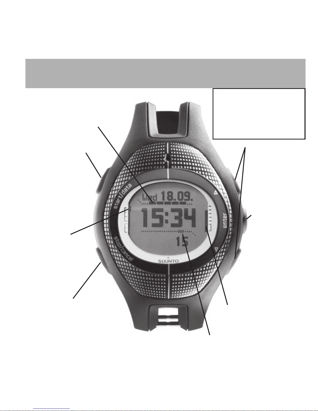
Suunto G9 User manual


HOW TO TURN THE GPS ON/OFF
In most situations you do not have to worry about turning the GPS on or off since
Suunto G9 starts and stops the GPS automatically.
You have to turn the GPS on manually if
• You have not started the Game or Course modes but you want to view the current position
coordinates in the Position display
• You have turned the GPS off in the Game or Course modes (for example to save power)
The GPS is turned off automatically when
• The QUIT ROUND is selected in the Game mode
• 18 holes have been completed in the Game mode
You have to turn the GPS off manually when
• You have stored course locations in the Course mode, but will not play the game
immediately
• The Home Position is stored with MARK HOME but you do not intend to use FIND HOME
immediately
• You have returned to the stored Home Position
To turn the GPS on or off:
1. Press ENTER for more than 2 seconds to enter the Function menu
2. Use UP or DOWN button to scroll to GPS On (or Off)
3. Short press ENTER. The On (or Off) word is highlighted
4. Press UP or DOWN button to change the On to Off or vice versa
5. Short press ENTER to accept the selection
6. Press STOP/CANCEL to exit the Function menu
See the backside of this page for information about the display and buttons.
NOTE: Pressing the ENTER button for more than 2 seconds in step 5 accepts the selection
and exits the menu.

START/DATA-button
Short press:
• Starts the stopwatch
or the compass
• Displays scores in the
Course and Game
modes
Long press:
• Activates the
backlight
DISPLAY AND BUTTONS
UP and DOWN
buttons:
• Switch between
main modes
• Scroll up and down
in menus
• Increase/decrease
the selected value
ENTER button
Shortpress:
• Enters submenus
• Accepts a selection
Long press
(over2sec):
• Enters the
Function menu
• Accepts the
selection and
returns to the
main menu
BATTERY LEVEL
• Blinking short bar: low battery
• Climbing bar: charging
GPS SIGNAL STRENGTH
• One hollow box: GPS on but no fix
• Bar of filled boxes: GPS has a fix:
Long bar means good signal
• Blinking hollow box:
GPS in the sleep mode
Mode indicator:
TIME
WEATHER
COMPASS
COURSE
GAME
STOP/CANCEL-button
Shortpress:
• Toggles shortcuts in the main mode
• Returns to the previous menu/field
Long press:
• Returns to the mode´s main display
• Resets the stopwatch ALARM INDICATOR
• Alarm or weather alarm is active
The Key Lock
Lock/unlock the keys by first
short pressing ENTER and
then START/DATA within 3
seconds. Black corners on
the display indicate that
keys are locked.

We recomend that you begin using Suunto G9 in the simplest way: by entering the par
values of a course and playing a round. This will get you aquinted with marking the
tees, ball positions and pins during a round. With this you will be able to see the
distances of each shot.
Once you are familiar with the basics, you can proceed to storing a course in the
Course mode, which will give you distances to these stored locations, such as tees,
bunkers etc.
The next stage is to start using your clubs and additional statistics to get a deeper
understanding of your game.
Your first round
At the clubhouse:
1. Scroll to the Game-mode with UP or DOWN.
2. Long press ENTER to access the Function menu.
3. Scroll to COURSE and short press ENTER.
4. Scroll to NEW and short press ENTER.
5. Modify the par value for the hole 1 with UP or DOWN and short press ENTER twice.
6. Enter par values for all the holes as you did for the hole 1.
NOTE! If you wish to enter fewer than 18 holes, long press ENTER after the last hole´s par
value.
7. Suunto G9 displays the text ‘Course date saved’, in which the date is the current date.
8. Now you are ready to play a round.
At the course:
1. In the Game mode, short press ENTER to access the Game menu.
2. START ROUND is highlighted in the Game menu. Short press ENTER to accept it.
NOTE! To avoid false selections by accidental pressing of the buttons, Suunto G9 returns
to the Game mode´s main display in 10 seconds if you do not select anything in the Game
menu.
YOUR FIRST ROUND

5
INTRODUCT
3. The GPS starts automatically. Once the GPS has a position fix, Suunto G9 displays the
text ‘Mark tee 1’.
4. Proceed to the tee box and short press ENTER to access the Game menu. MARK TEE is
highlighted. Short press ENTER to accept it.
6. Strike your opening shot.
7. Proceed to your ball in play.
8. Short press ENTER to access the Game menu.
9. MARK BALL is highlighted in the Game menu. Short press ENTER to accept it. ‘Shot 1
marked’ is displayed.
10. Repeat steps 8 to 10 until your ball is in the pin.
11. Once in the pin, short press ENTER to access the Game menu and scroll to END HOLE.
Press Enter to accept the selection.
12. Suunto G9 displays the number of putts (default 2). Modify the number with UP/DOWN
and accept the selection with ENTER.
13. The total score is highlighted. If this is not correct (you have forgotten to mark a ball
position), modify it with UP/DOWN and accept it with ENTER.
14. Proceed to the next tee.
More info about:
• Display and buttons, see the sideleaf of the front cover
• Playing the game and penalties, see the Game mode at pages 24-27
NOTE! The very first time you initiate the GPS, it will take longer than usual for the GPS to
start, as it has no reference to its current location. This may also happen if the GPS has not
been used for a long time.
Please activate your new Suunto G9 GPS at least once before going to the golf course.
Subsequent GPS starts will take less time. To minimize the GPS initiation time, hold the
unit steady in one position with the display facing up and make sure you are located in an
open area so that the unit has a clear view to the sky. After starting the GPS (i.e. after it has
a fix), the unit can be moved more freely without losing the connection to the satellites. The
signal strength bar on the unit’s display indicates the fix. (See page 3, Display and
buttons.)

6
THE SUUNTO G9 CONCEPT BRIEFLY
Suunto G9 is designed to help you to measure and understand your game. Only when
you understand your strengths and weaknesses, you will be able to focus on your training
properly. To gain this, Suunto G9 will provide you with a possibility to
• Measure your strokes so that you know how far you really strike with each club
• Store statistics of each game: number of putts, number of bunker hits, did you have a
fairway hit and whether you reached the green in regulation
These are the key features. By storing this information and analyzing it with the Suunto
Golf Manager Software, you will be able to learn more about your game, see how your
game develops and what you should do to make it even better.
In addition to this you can store your favorite courses or check from the Suuntosports.com
whether someone else has stored them and download them to your Suunto G9. Having
the course key points stored, Suunto G9 will give you distances and directions to tee,
green, pin and other obstacles such as water or bunkers on each fairway.
By keeping your club database in Suunto G9 and Suunto Golf Manager Software updated,
you can easily select the most suitable club for each strike.
Suunto G9 also includes a chronometer with time sync from the GPS satellites, a barometer,
an altimeter, a compass, GPS position display and a practical Mark home/Find home
function.

7
Each main mode in Suunto G9 has a submenu, which can have one or more submenus.
You navigate in the menus with the ENTER, UP/DOWN and STOP/CANCEL buttons.
ENTER Change the value
with UP/DOWN
Press ENTER for over 2 sec
ENTER Function menu
GPS On/Off
See pages 12-13
Timemenu
ALARM
TIME/DATE
UNITS
GENERAL
TIME 24h
DATE dd.mm
TEMP °C TIME 24h
DATE dd.mm
TEMP °C
ENTER
ENTER: accept and return
STOP/CANCEL: discard and return
ENTER for over 2 sec: accept and return to the main display
STOP/
CANCEL
STOP/
CANCEL
Scroll the menu
with UP/DOWN
NAVIGATING THE MENUS

8
BEFORE YOU START
Before you start using your new Suunto G9, you should do the following:
• Charge the unit
• Read through this manual
To get the most out of your Suunto G9, you should also install the included Suunto Golf Manager
software. The Suunto Golf Manager CD includes a more detailed manual of all features.
CHARGING THE BATTERY
Suunto G9 is equipped with Li-Ion rechargeable battery. You can charge it from the mains outlet
with the included charger, from a 9V battery or from your car’s cigarette lighter (optional).
To charge the unit, place the Suunto G9 on the docking station as shown in the picture
and connect the charger to the docking station. During charging, the battery level indicator
will continuously climb from bottom to top. When the battery is full, the battery level
indicator is fully displayed.
To connect the docking station to your PC, connect the telephone modular jack of the
interface cable to the docking station and the 9-pin D-connector to a free serial port in
your PC. (If your PC does not have a serial port, you have to purchase a USB to serial port
-adapter separately.)

9
Only perform the procedures described in this manual. Never attempt to disassemble or
service your Suunto G9. Protect your Suunto G9 from shocks, extreme heat and prolonged
exposure to direct sunlight. If not in use, your Suunto G9 should be stored in a clean, dry
environment at room temperature.
Suunto G9 can be wiped clean with a lightly moistened (warm water) cloth. If there are
stubborn stains or marks, you can apply mild soap to the area. Do not expose Suunto G9
to strong chemicals such as gasoline, cleaning solvents, acetone, alcohol, insect repellents,
adhesives and paint, as they will damage the unit's seals, case and finish. Keep the PC
interface pins clean with e.g. a toothbrush. Make sure the area around the sensor is kept
free of dirt and sand. Never insert any objects into the sensor opening.
WATER RESISTANCE
Suunto G9 is water resistance-tested up to 10 bar (equivalent to 100 m/330ft depth)
according to ISO 2281 standard (www.iso.ch). However, it is not a diving instrument and
therefore it should not be used to obtain data under water. Do not push the buttons under
water.
NOTE! Lots of water or dirt under the cover of Suunto G9 may disturb the satellite signal
reception.
MEMORY
The data memory in Suunto G9 is non-volatile i.e. data is not lost even if the battery runs
out.
CARE AND MAINTENANCE

10
UNDERSTANDING GPS
OVERVIEW
Suunto G9 uses Global Positioning System (GPS) in determining the user’s position.
GPS incorporates a set of satellites orbiting the Earth at an altitude of 20 000 km at the
speed of 4 km/s. The satellites send relatively weak radio signals at power levels
comparable to normal household light bulbs. So, the GPS reception gets disturbed much
more easily than, for example, cellular phone signal reception because the GPS signals
that reach the Earth are thousands of times weaker than cell phone signals. However, due
to the extreme sensitivity of the built-in GPS radio receiver, even the faintest signals can
be picked up.
The GPS system is run by the United States Department of Defense and has been fully
operational since 1995. At least 24 operational satellites circle the globe every 12 hours
in 6 orbital planes with 4 satellites per plane to provide a true global coverage. A
worldwide ground control network monitors the health and status of the satellites. The
system works 24 hours a day regardless of the weather. It can provide service to an
unlimited number of users and it is free of charge.
LINE-OF-SIGHT NEEDED
To ensure a good position measurement, there must be a line-of-sight connection between
the satellites and the receiver. This means that the objects or materials between the
satellites and the GPS receiver must not excessively attenuate the signal. In practice,
water-containing objects, such as people, trees or other dense vegetation, can cause
problems. The signals will not penetrate rocks or buildings or any metallic materials.
However, the receiver typically works well under relatively thin plastic, fabric or wooden
covers, e.g. inside boats.
ACCURACY
To calculate a position, a GPS receiver usually requires simultaneous reception from at
least four satellites. The position accuracy typically increases with the number of satellites
being tracked but the most important factor is actually the relative geometric position of
the satellites. The best position estimate is obtained when satellites from different directions
and angles can be tracked. In other words, the less obstructed the receiver’s view of the
sky, the better the accuracy.

11
The accuracy also improves with the number of measurements made on the same spot,
as some errors will be averaged out. Under all-in-view satellite conditions a global
average horizontal positioning error is 7.8 meters (95% confidence level). However,
depending on the satellite constellation and the distortion the GPS signal experiences
when traveling through the ionosphere, the instantaneous accuracy can vary from a
couple of meters to over ten meters. The vertical position estimate is roughly two times
more inaccurate than the horizontal. Because of this inevitable vertical inaccuracy of
GPS positioning, Suunto G9 encases a separate altimeter sensor with a 1-meter resolution
that should be used instead of the GPS estimate when measuring small changes in
altitude.
GPS USAGE
When you turn on the GPS, the receiver starts searching for radio signals from the
satellites and as soon as one is found, data starts flowing from the satellite to the receiver.
The data includes a list of the satellite positions and the GPS time. The GPS time is
highly accurate because each satellite has an atomic clock on board.
The data flows quite slowly and usually a little less than a minute is needed for the
calculation of the first position estimate. To minimize the duration, you should maintain
an unobstructed view of the sky right after turning on the GPS. Keeping the receiver
stationary will also improve the initialization. You need the satellite positions and the
GPS time before the receiver can perform the actual position calculation and before the
GPS becomes functional. After the first position fix has been established, it still takes
additional 10 minutes before all relevant data has been received from the satellites. The
position estimate accuracy improves during this time as more satellites can be used for
calculation.
The downloaded data is valid roughly for the next four hours during which the receiver
starts more quickly, typically in less than 10 seconds if it was turned off in between.
You should turn off the GPS when, for example, you have a longer break. This is because
satellite tracking consumes large amounts of power. Suunto G9 uses the lowest power
consuming GPS technology available but you should still turn off the GPS when you do
not need it.

12
The function menu is almost identical in all the main modes. It is always accessed from
the mode´s main display by pressing ENTER for more than 2 seconds. In the Function
menu you can:
• Turn the GPS on or off manually (GPS On/Off)
• Create, activate or modify a golf course (COURSE)* see the Course mode-section.
• Select which bag to use and view the clubs of both bags (CLUBS)*
• Mark your home position (MARK HOME)
• Guide back to the stored home position (FIND HOME)
• View position information (POSITION)
• Turn the GPS power save on or off (PWRsave On/Off)
• Turn the statistics query on or off (STATS On/Off)
(Functions marked with * are displayed only when the menu is accessed from the Course
or Game modes.)
FUNCTION MENU
MARK HOME
GPS starts automatically and your current position is stored as your home position.
FIND HOME
GPS starts automatically and a guidance display will show the direction and distance to
your stored home position.
NOTE! If you move faster than 5 km/h (3,2 mph), the direction guidance is based on GPS
heading. At lower speeds and at standstill a compass direction is shown.
PWRsave On/Off
If the power save is turned on, the GPS is set to sleep for one minute after you mark each
tee, and for two minutes after you select END HOLE in the Game mode. You can modify
these times in the Suunto Golf Manager.
You should turn this feature on if you play slowly or if there are many players in your
group.

13
POSITION
When the GPS is on, the position display shows:
• Map datum in use (default is WGS84)
• Number of satellites used in fix/number of satellites visible (SAT)
• Estimated position error (epe)
• Your current position coordinates, latitude and longitude in degrees or in degrees and
minutes
• Your current altitude measured by the GPS or the time to the first fix (toggle with START/
DATA button)
You can change the coordinate presentation in the Time mode (General settings). The
map datum is changed in the Position display with the UP/DOWN buttons. Available
datums and their numbers are listed in the end of this manual. The coordinates are
updated in the selected datum in a few seconds.
NOTE! Selecting a datum affects only the Position display. All position logging and
measurements are made with WGS84.
CLUBS
You can have two bags of clubs stored in your Suunto G9. In CLUBS you can select which
bag to use, and view clubs of each bag and their average distances. You can modify the
bags in the Suunto Golf Manager.
When you select a club for a shot, the contents of the bag in use are displayed and the
stroke distances are updated for this bag.
STATS On/Off
If the STATS are set to On, Suunto G9 will show/prompt for additional statistical information
after you have selected END HOLE in the Game mode. This information includes:
• GIR (Green In Regulation)
• Fairway hit (Yes/No)
• Bunker hits (number of)

14
TIME MODE
DATE
TIME
Seconds, Stopwatch
or Dual time. Toggle
withSTOP/CANCEL
THESTOPWATCH
START/DATA
• Starts the stopwatch
• When the stop-
watch is on, it stores
lap times
STOP/CANCEL
• Stops the stopwatch
• After the stopwatch
is stopped, it
reviews lap times
• Long press (more
the 2 sec) resets the
stopwatch

15
The Time settings menu can be accessed by short pressing ENTER. This menu contains
functions for setting the alarms (ALARM), setting the time and date (TIME/DATE), setting
the units (UNITS) and for adjusting general settings (GENERAL).
ALARM
You can set 3 different daily alarms. Alarms can be acknowledged by pressing any button.
TIME/DATE
TIME/DATE for setting the time and date manually
DUAL TIME for setting the dual time displayed on the lowest field of the display
SYNC for setting the GPS time synchronization to ON/OFF/AUTO:
OFF GPS does not affect the time settings
ON GPS adjusts the time and date to the time zone specified in the Suunto
Golf Manager (your local time zone) when the GPS is activated
AUTO Suunto G9 calculates the time zone based on the rough time set manually
and adjusts the time from the GPS to this time zone.
UNITS
TIME time is shown in 24h or 12h format
DATE date is shown in dd.mm or mm.dd format
TEMP temperature is shown in Celcius or in Fahrenheit
PRES pressure is shown in hPa or InHg
ELEV altitude is shown in meters or feet
DIST distance is shown in meters or yards
POSITION position coordinates are shown in degrees (deg) or in degrees and minutes (dm)
GENERAL
LIGHT sets the backlight to On/Off/Night. When set to night use, pressing any
button activates the backlight.
NOTE! Unnecessary use of the backlight consumes a lot of power.
BRIGHT sets the backlight brightness.
NOTE! Higher brightness consumes more battery. Default setting is 3.
CONTRAST sets the LCD contrast.
NOTE! High contrast consumes more battery. Default setting is 4.
TONES Sets the button tones On/Off

16
WEATHER MODE
Pressure at sea
level (derived
from absolute
pressure)
Barometric
trend
Temperature/Absolute
pressure/Altitude
TogglewithSTOP/CANCEL

17
The Weather mode gives you practical information on:
• Sea level air pressure (derived from the absolute air pressure based on the current alti-
tude)
• Air pressure trend
• Temperature
• Absolute air pressure
• Altitude (barometric)
The barometric trend display shows changes in air pressure during the last 6 hours in 15-
minutes intervals.
The Weather settings menu is accessed short pressing ENTER:
ALTITUDE
• Allows you to set the reference altitude (your current altitude) manually or from the GPS
MANUAL modify the altitude with UP/DOWN button, accept with ENTER
SYNC ON: reference altitude is set from the GPS every time the GPS is
started (average of several GPS fixes).
OFF: manually set reference altitude is used.
BARO MEM allows you to view the barometric trend for the last 7 days. The trend is stored
in 1-hour intervals, so each display shows 24 measurements. On the lower section of each
display, maximum and minimum air pressures for that the day are shown.
Scroll between days by pressing the UP/DOWN buttons
NOTE! Since the barometric altimeter is affected by changes in weather i.e. changes in the
air pressure, you should set the reference altitude each time you start using the altimeter
feature. If SYNC is set to On, start the GPS before starting to use the altimeter.
BARO AL sets the barometer alarm on or off. The barometer alarm warns you when the
air pressure drops faster than 4 hPa (0,118 inHg) in 3 hours, which is typical in situations
when a storm is arising. If you do not acknowledge the weather alarm, it is repeated in 10
minutes.

18
COMPASS MODE
Cardinal or half
cardinal point
abbreviations
Bearing in
degrees
Time/Locked bearing/
Bearing to a course point
Toggle withSTOP/CANCEL
Starts the compass
after time-out.
Locks the bearing
in the bearing mode

19
The Compass mode utilizes the Suunto 9-series 3D compass, which allows reading the
compass reliably even if the unit is held tilted up to 30 degrees from horizontal to any
direction.
Since the compass feature consumes a lot of power, the compass is automatically turned
off after 45 seconds, after which it can be restarted with START/DATA.
The compass shortcuts are:
• Standard compass mode (with time in the lowest field)
The first row displays the cardinal and half-cardinal point abbreviations
The second row displays the bearing in degrees
• Locked bearing
In this mode you can lock the compass to any bearing by pointing the unit to the
desired direction and pressing START/DATA. The locked bearing is displayed in
the lowest field. By turning the unit so that the small circle is between the lines, the
unit points to the locked bearing. If the circle is not visible, a small arrow shows
where the unit has to be turned.
• Bearing to a course point
Once you have started a round and have selected a stored course point in the Course
mode (for example a bunker), this shortcut in the Compass mode shows you the
direction to this course point. This is very practical when the course point is not
directly visible.
The Compass settings menu is accessed by short pressing ENTER. Here you can:
• Set the declination (DECLINATION)
• Calibrate the compass (CALIBRATE)
DECLINATION
You can set the declination to:
Off The compass points to the magnetic north
On You can set the declination manually
Auto Declination is set from the declination grid based on your current position.
The globe is covered by a 4-degree grid (45 x 90 declination values)
CALIBRATION (see page 34)

20
COURSE MODE
Name of the
stored obstacle
Number of
stored obstacle
Hyphen(s) indicate
the number of other
stored obstacles
Toggle to select
obstacles for
viewing and
for compass
direction display
Distance to
obstacle
PressENTER
for menu to
store more
obstacles
Other manuals for G9
1
Table of contents
Other Suunto Watch manuals

Suunto
Suunto 9 2.0 User manual

Suunto
Suunto X6 User manual

Suunto
Suunto Vector User manual

Suunto
Suunto X6 User manual

Suunto
Suunto TRAVERSE ALPHA 2.0 User manual

Suunto
Suunto LUMI User manual

Suunto
Suunto AMBIT3 RUN 2.0 User manual

Suunto
Suunto X9 User manual

Suunto
Suunto D9 User manual

Suunto
Suunto N3 User manual

Suunto
Suunto n6HR User manual

Suunto
Suunto X9 User manual

Suunto
Suunto Spartan Sport User manual

Suunto
Suunto MARINER | REGATTA | YACHTSMAN User manual

Suunto
Suunto AMBIT2 R 2.0 User manual

Suunto
Suunto 9 Peak User manual

Suunto
Suunto TRAVERSE ALPHA 2.1 User manual

Suunto
Suunto Tank POD Owner's manual

Suunto
Suunto Observer User manual

Suunto
Suunto X6HR User manual