Hi-Target SL300 series User manual

HandheldGNSSReceiver GIS Data
Collection

Handbook revisionsituation
Revision date Revision times introduction
2012.8 1 Handheld GNSS Receiver GIS
Data Collection
V1.0
Preface
Useoftheintroduction
Welcome touseSL300 serieshighprecisionmobileGISproductintroduction,this manualappliesto
Qstar series, this manual introduced howtoset and useSL300 serieshighprecisionmobileGIS
product.
Specificationoftheintroduction
SL300 series highprecisionmobileGISproductis anewGPS/GISdata collector, evenifyouhave
used other types ofindustrial GISdata collector, pleasecarefullyread this instructionbeforeuse
Experiencedemand
Inorder that youcanbetter useSL300 serieshighprecisionmobileGISproduct,Hi-Target
suggests that youhaveacertainknowledgeofmeasures or GIS, andcarefullyread this manual. If
youhaveanyquestions, pleaserefer to theofficial website ofHi-Target:
<http://www.hi-target.com.cn >.
Safetytechnical note
Responsibilityabsolution
Beforeyouusetheproduct,youshould readtheintroductioncarefully.Hi-Targetsurveying
instrumentCo.,LTD.will nottaketheresponsibilityifyoudo notoperate withintheproduct
instruction
HI-TARGETsurveyinginstrumentCo.,LTD.is committedtocontinuouslyimproveproduct
functionandperformance,improvetheservicequality,andkeeptherighttochangethecontentof
theinstructionwithoutnoticing inadvance.
Wehavecheckedthat whetherthehardwareandsoftwareareconsistentwiththecontentasthe
printssay, butwe don'truleoutthepossibilityofbias, thepictureintheinstructionfor reference
only, ifyouhaveaproductwithdiscrepancies, pleaserefer to theproduct.
Technology and service
Hi-Targethavesetup the technologyand service”section inwebsite,ifyouhave
problemsyou can settlethemthrough the"serviceguide"telephone 、contactingregional
technologycenter and headquartersdivision orthroughthe"expertsonthejudgment
seat,""technologyBBS"message, wewill answer yourquestions as soon aspossible.
Note:payattentionto thesuggestivecontent,itis generallyspecial place,need
to draw your special attention, pleaseread itcarefully
Warning:thecontentofthewarning is generallyveryimportanthints, ifnot
operate withinthewarning content, itwill causethedamageofinstrument,
theloss ofdata, and thecollapseofthesystem, and evenendanger personal
safety.

Related information
You can find theinstructions through thefollowingmethods:
1PurchasedproductsfromtheHi-Targetwill withaCD,opentheCDand you canfind
theinstruction;
2Land theofficialwebsiteoftheHi-Target,through"downloadedzone"—"product
specifications "—"GISproduct"and you can it.
Yoursuggestion
Ifyou haveanysuggestions and opinions abouttheintroduction, pleasevisit theofficial
websiteoftheHi-Target,and leavemassagein"technicalservice" —"adviceand
complaint"edition ,yourfeedbackwill helptoimprovethequalityoftheintroduction
greatly.

Chapter1
Productsoverview
Thischapter introduces:
Product introduction
■Product features
Mattersneeding attention inuse
CHA PTER
1

Product introduction
SL300 serieshighprecision mobileGISproductsare equippedwithcompletenavigation
and position function and GISdataacquisitionfunction, withtheoperatingmodeof
physicalbuttons and touchscreen, inputtinginbothChineseand English aresupported. It
isdesignedas industrialstandard, and canbedroppedfrom1.5 metershigh tothecement
floorwithoutanything,equippedwithIP67 leveldustproofand waterproof,it canadapt
tocomplexworkenvironmentinthefield. Atthesametime,theconfiguration ofthelarge
capacityoflithiumbatterycan meettherequirements ofall daywork.
SL300 serieshighprecision mobileGISproductsareintegrateddesigned,and it
isequippedwithfunctions suchasGPS,embeddedWindowsMobile6.5 system,digital
camera,microphone,bluetoothcommunication, largestorage,USBport,SDcard
expansion ,etc.
Productfeatures
◊Industrial integrationdesign, withavarietyoffunctions
◊Can beused as theindustrialthree proofstandard GPS navigation
◊Thebuilt-indigitalcamera,whichcanrealizeimageinformation siteacquisition,
automaticallyrealizeGPScoordinates and imageinformation matchinglabeling
◊Thebuilt-in microphone, it can realizevoice information sitecollected
◊withthefunction ofspeech play
◊Thebuilt-inbluetooth, torealizethewireless datatransmission
Useand the mattersneedingattention
AlthoughSL300 serieshighprecision mobileGISproductsusethecorrosion resistance
and impactresistance materials, buttheinstrumentstillneedourcarefuluseand
maintenance,and keepit indryenvironmentasfar aspossible.Inorder toimprovethe
stabilityoftheSL300 serieshighprecision mobileGISproductsand usecycle,please
avoidSL300 serieshighprecision mobileGISproductsexposedtoextremeenvironments,
such as:damp, high temperature, lowtemperature,corrosivegas orliquid, etc.
Warning:Qstar serieshighprecision mobileGISproductsmustbe
preservedand usedwithinstipulatedtemperature range.Detail
requirements, pleasereferto chapter 4:technicalparameters.

Toensure continuous observation ofthesatelliteand satellitesignalquality,thestations
shouldbesetovertheopenplaceasfaraspossible,barriersarenotpermittedinmore
than15 degree;Toreduce theinterference ofelectromagneticwavetoGNSS satellite
signal,within200 mstrongelectromagneticinterferenceisnotpermitted, suchasTV
tower,microwavestation, highvoltagetransmission line;Toavoidorreduce the
happeningofthemultipatheffect,stations shouldbefarawayfromtotheterrainwhich
reflectelectromagneticwavesignalstrongly, suchas high building, slicedwaters, etc.
FCCID: AJYSL300
This device complies withPart15 oftheFCC Rules. Operationis subject
to thefollowing two conditions:(1)this device may notcauseharmful
interference, and (2)this device mustacceptany interference received,
including interference thatmay causeundesiredoperation.

Chapter2
Theintroduction ofSL300series high precision
mobileGISproducts
Theintroduction ofthis chapter:
■thefrontofSL300 series high precision mobileGISproducts
■theback ofSL300 series high precision mobileGISproducts
■Interface
■touchingpen
■battery
■datacable
■belt
This chapter introduces SL300 series high precision mobileGISproducts
appearance, interface, battery, touch pen and datacable, etc.
ThefrontofSL300 series high precision mobileGISproducts
ThefrontofSL300 serieshigh precision mobileGISproducts
,includingthetouch screen, keyboard, amicrophone,protection set,etc.
CHA PTER
2
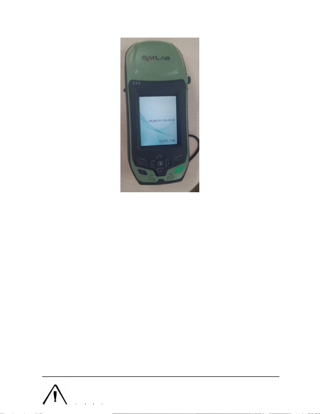
◊Touchscreen:3.7 inchverticalscreencando clickoperationdirectly,supportinputting
in both Chineseand English.
◊Protectiveset: incasethatit grind、fell andshock, effectivetoavoidinstrument
scratching.
◊Keyboard:direction control, theconfirmation button, exit button, switchmachineetc.
◊Themicrophone:built-inmicrophonecanbeusedfortheacquisition ofvoice
messages.
The backofSL300 serieshighprecisionmobileGISproducts
Theback ofSL300 serieshigh precision mobileGISproducts
, includingthecamera, battery, thebelt hole, horn, etc.
◊Camera:built-in digitalcameraforvideo information sitecollection
◊Battery:thebuilt-in 3.7V, 8800 mAh lithiumbatteries
◊Belt :connectthestrapto preventslide.
◊Horn:instrumentreal-timeoperatingstateand speech broadcast
Note:whenthehornisinwater,it mayappear silentorhusky,dryit andit will
bebacktonormal.Theloudspeakerand theinstrumentiscompletely
waterproof, horn with water will notaffectinstrumentperformance, butplease
timelydryit.
.
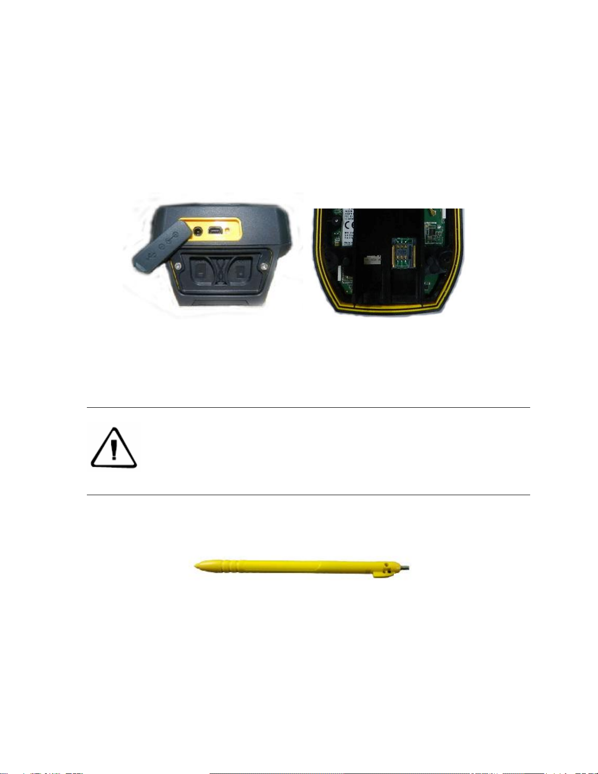
Interface
SL300 serieshighprecision mobileGISproductsinterfaceposition isidentified,itsmain
function is chargingand datatransmission, installingSIM card and SDcard, etc.
Picture2-3
◇Charginginterface:connectthechargerforlithiumbatterycharge.
◇USBinterface:theconnection computer, usedfordatatransmission.
◇SIM card socket:to install SIM card
◇MicroSDcard slot:it can beinstalled MicroSDcard, can support32 GBatmost.
Touchingpen
SL300 serieshighprecision mobileGISproductstouchingpenisequippedwithstandard
configuration, located inSL300 series high precision mobileGISproductsbelt .
Picture2-4
Battery
This illustration shows thestandard 8800 mAh lithiumbatteryappearance figure.
Note:whenthecharging interface and USBinterfacearenotinuse,please
cover thestopper, in orderto achievethepurposeofwaterproof, dustproof.

Picture2-5
Datacable
Picture2-6
◇SL300 serieshighprecision mobileGISproductsinterface:used in connection ofUSB
withSL300 series high precision mobileGISproducts.
◇USBinterface:toconnectcomputer USBport, used fordatadownload.
Belt
BecauseSL300 serieshighprecision mobileGISproductisbig, in order to preventsliding
intheprocess ofworking,it isequippedwithantiskidbelt,pleaseentanglebelt whenyou
work.
Notice:Inorder toprotecttheenvironment,whenthelithiumbattery
failure,do notthrowthemaway,pleasereturn toHi-Targetorprofessional
batteryrecyclingunits processing.
Warning:when thecableis notin use,it shouldbepackedinwhere theplaceis
noteasyto squeezeto preventdamageto theplug.

Picture2-7
Chapter3
Basicoperation
Theintroductionofthissection:
▇keyboard
▇Touchingpen
▇MicroSD card
▇Power supplysystem
▇Switch machineoperation
▇dataobtain
▇Application functions
MostoftheHi-TargetSL300 serieshighprecision mobileGISproductssettingand
operation can becompleted bytouchingpen , thecommon operation can becompleted by
thekeyboard.Nowwewill introduce theappearance and function ofthekeyboardsimply.
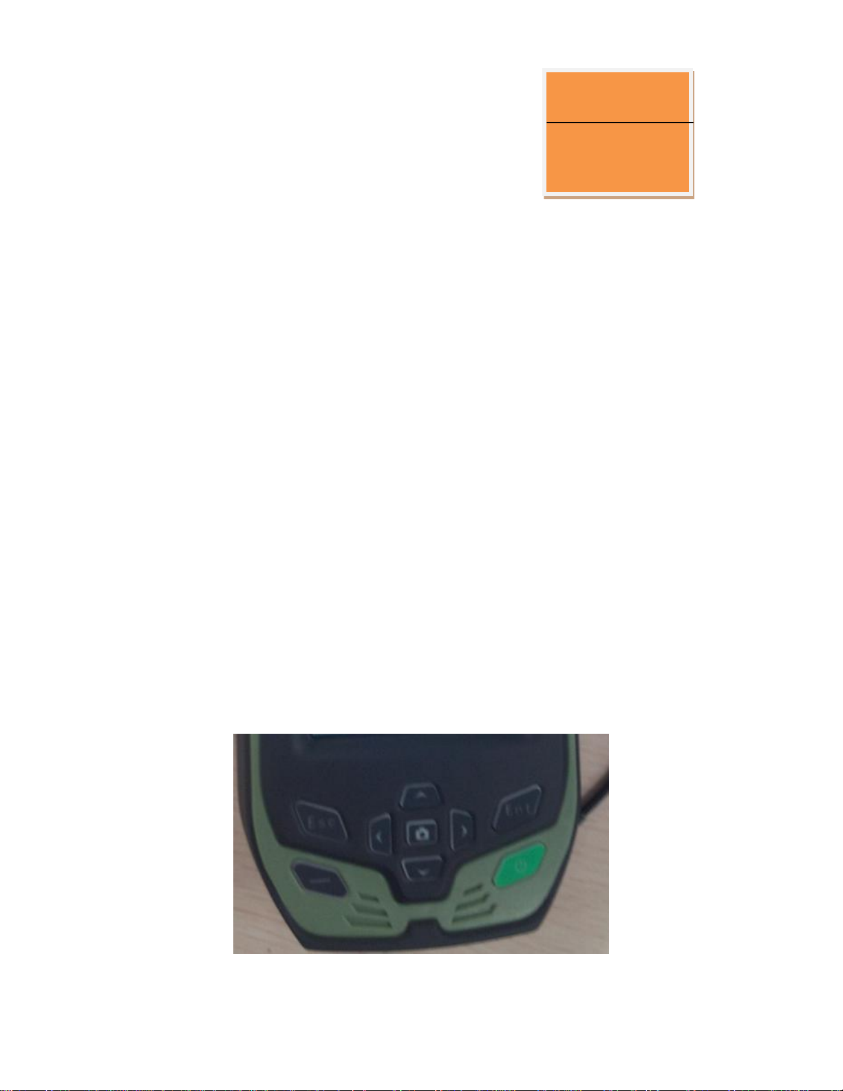
Keyboard
SL300 series high precision mobileGISproductskeyboard. Thekeyboard keyscontains:the
confirmationbutton,exit key,F1functionkeys, switchmachinekeyand thedirectionkey.
CHA PTER
3

Figure 3-1
ESC”exit button:shortpressitonboot-upstate,meanstocancelorexitthecurrentwindow
operation.
ENT”Confirmbutton:okbutton.
Switch machinebutton/backlightcontrolbutton:longpressitformorethan3seconds
toturnson/offit.Onboot-upstate,holdthebuttonfor1second,switchonor off the
backlight.
Navigation button:movethecursor, tochoicetheoptionscontent.
MicroSD card
Canbeused for storageofthecollected data and program files. Program installationpackagecan
beinstalled to program MicroSD card, justas installed insystem diskspace.
Power supplysystem
Thebatteryinstallationand removal
Install thebattery,contactthebatterywithametalconnector ononeendwith SL300 series high
precision mobileGISproduct batteryjar copper point, and screw up thescrew.
Takeoutthebattery,takeoutthescrew firstly,thebatterywillpopuplittle,thenyoucantakeitout.
Notice:whenQstar serieshighprecision mobileGISproductisnotin work
temporarily,pleaseclose abacklighttosaveelectricity,toextendindustrial
GISdatacollectorworktime.
Note:theMicroSDcards (also namedTFcard)aresmall volume externalflashmemory
storageexpansionCARDS,usuallyusedinmobilephone,PDA,users should distinguishit
betweenthecommonSDcard. Thevolume ofordinarySD card arelargerthanthe
MicroSDcard, notsuitableforQstar serieshighprecision mobileGISproduct .Qstar
series high precision mobileGISproductcansupport32 GBMicroSD card at mostfor
present.

SL300 series high precision mobileGISproductbattery, charger model number
Table 3-1SL300series highprecision mobile GISproductbattery,charger model
name model
8800mAh lithium batteries BL-8800A
Lithium batterycharger CL-00A
charge
Whencharging,thechargershould bespecializedchargerwithstandard configurationorseat
chargerincertaintemperaturerange,andchargingtime should achieveacertainrequirements.
Theconcrete usemethodandrequirements:chargingwithstandard configurationis demanded
whenchargingtheSL300 serieshighprecisionmobileGISproduct,chargein10 ℃~40 ℃
temperaturerange.Usingfor thefirsttime ingeneral,thereshould besome batterypower,you
should useuptheinsideelectricitybeforechargingagain,thefirstthree chargingmustachieve12
hours,afterthat charging6hours.Ifthebatteryisnotofteninuse,itmustbechargedoncea
month.
Switch machineoperation
Boot
Intheshutdownstate, longpress three seconds, itwillboot.
Warning:1Thebatteryandchargermanufacturerconfigurationareonlypermitted,do
notputitinto thefireor metal electrodes withshortcircuit.
2Ifyoufindthebatteryhasfever,deformation,discharge,smell or other
abnormalphenomenonwhenthebatteryisinuse 、inchargeor instorage,please
replacenew battery.
3Iftheusetime ofthebatterysignificantlyshortened, pleasestopusingthebattery,
thebatteryis aging, pleasereplacenew battery.
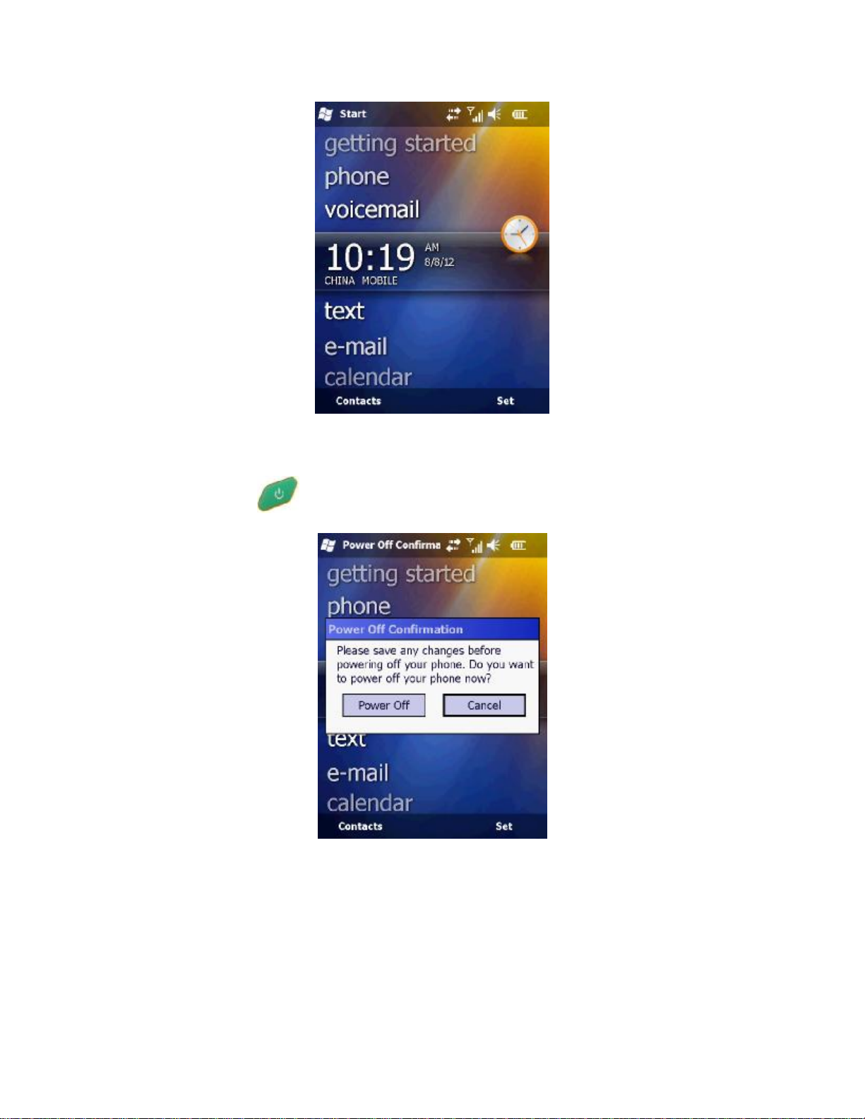
Figure 3-9
shutdown
Onstate,longpress 3seconds, itwill tip youtoconfirmshutdown,clickonthe"shutdown".
Figure3-10
Networkconnection
Click"start"->"DialConnect",ifyouhaveset updial-upparameters, click"dial-upconnection",you
candirectdialing. Ifyoudid notclick "new connection", thenclick"dial-upconnection".
For successfuldial-upnetwork,youcanclick "disconnect"to closetheconnection.
Tip:after thesuccessfullydial-up ,don'tclickonthetoprightcorner "OK"button, click onthetop
leftcorner "start"to do other operation
Data obtain
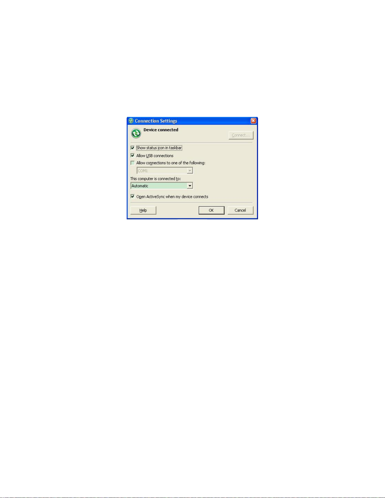
1InstallMicrosoft ActiveSync
Intheincidentaldisk(tool software\connectionprogram \ActiveSync),doubleclickMSASYNC45.
exefile,pleasefollowtheinstructionstocomplete installation.Aftertheinstallation,find
MicrosoftActiveSyncandoperate itinthe"startmenu""program".Set up"allowstheUSB
connection" Inthemenu "connectionSettings", as showninfigure4-21.
Figure3-11
2Thehardwareconnection
First,switch onSL300 serieshighprecision mobileGISproduct,entertheWindows
system,itis noneedtoopenapplications.ConnecttheUSBportwhich withasmallercablelinewith
theSL300 serieshighprecision mobileGISproduct ,connecttheotherendUSBplugwith
your PC.
3Softwareconnection
Whenthecableisconnected,the MicrosoftActiveSync inthecomputerwill tipsyou"whether
needtoestablishcooperationrelationship,"choose “cancel”, ThenMicrosoftActiveSyncpopupa
hint,click"ok" Thenithasbeenconnectedsuccessfully.Ifitis thefirstconnections, the
computerwill tipsyoutoinstall thedriver,justinstalledWindowscompute driveraccordingto
guide.
4download data
Clickonthe“browsebutton”oftheMicrosoftActiveSync,opentheresourcesbrowserof SL300
serieshighprecision mobileGISproduct,youcanentertherelatedfileandcopydata tothe
computer.
Application functions
SL300 serieshighprecision mobileGISproductis equipdewithPPP technology(the
technologyusedinQminiMPmodel),built-inGPSnavigationandpositioning, digitalcamera,
microphone,3Gcommunications(this functionis optional),andotherfunctions, butitmustbe
installed withthecorresponding software.SL300 serieshighprecision mobileGISproduct is
equippedwithHi-Qsoftware,astohowtouseHi-Qsoftwaretooperate oftheapplicationfunctions
above, pleaserefer to mycompany's"Hi-Qsoftwareoperationinstruction"content.

Chapter4
Technologyparameters
Theintroductionofthis section
Technologyparameters
Technologyparameters
This chapterwillintroducesyourelatedparameters ofSL300 serieshighprecision mobileGIS
product,theproductfunctionwillvaryaccordingtothedifferentmodels. Whenyourefertothis
chapter,pleaserefertocorrespondingtechnicalparameters accordingtotheequipmentyou
purchase.
\
model
System configuration
Operatingsystem: WindowsMobile6.5
√√√√√
806MHzhigh-speed CPU √√√√√
Memory: 256MB RAM
√
√
√
√
√
Flashmemory:8GB
√
√
√
√
√
Screen: 3.7inchescolor touchscreen,640 x
480resolution
√
√
√
√
√
GPS characteristics
HighsensitivityGPSpositioning technology √√√√√
GPS+GLONASSbinarystarpositioning
technology
SupportSBAS(WAAS,EGNOS,MSAS)√√√√√
Positioningtimeforthefirst
ime:30second(typical) √√√√√
Positioningaccuracy
Pointpositioning:5m √√√√√
SBAS:1-3m √√√√√
PPP(accurate point
positioning)technology:1m
applicationfunction
5millionpixelcamerawithLEDthefill light √√√√√
CHA PTER
4

Integrated microphoneandspeakers √√√√√
Thebuilt-inbar codescanner √
Data communication
Bluetooth:bluetooth √√√√√
Interface:Mini USB interface √√√√√
Storage:Micro SDcard slot, 32 Gat most √√√√
Power performance
Standard configuration3.7V,3100mAhlithium
batteries
Canworkcontinuouslyover12 hours support
onlinecharge
√√√√√
Physical properties
Key: 10 buttons,withfourthedirectionkey
andshortcutkeyintheside
√√√√√
Size:14cm×8cm×3.5cm
Weight:360g(containbattery) √√√√
Work temperature: -30℃~+70℃storage
temperature:- 40℃~+80℃√√√√
Dustproofwaterproof:IP67 √√√√
Shockproof: Resistanceto1.5mfree fall √√√√
Table of contents
Other Hi-Target Receiver manuals

Hi-Target
Hi-Target iRTK5 User manual

Hi-Target
Hi-Target vRTK User manual

Hi-Target
Hi-Target V100 User manual

Hi-Target
Hi-Target V100 User manual

Hi-Target
Hi-Target V90 Plus User manual

Hi-Target
Hi-Target V200 User manual

Hi-Target
Hi-Target V90 Plus User manual

Hi-Target
Hi-Target V60 User manual

Hi-Target
Hi-Target V100 User manual

Hi-Target
Hi-Target V30 User manual


