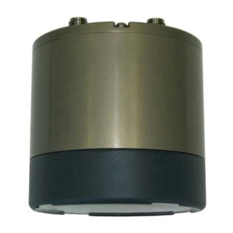
IMAGENEX DT101Xi User manual

Technical Manual
Set up and Configuration of the
Imagenex DT101Xi / DT102Xi
Multibeam Echosounder
Imagenex Technology Corp.
209-1875 Broadway Street
Port Coquitlam, BC
Canada V3C 4Z1
Telephone: +1 (604) 944-8248
Fax: +1 (604) 944-8249
www.imagenex.com
DT101Xi / DT102Xi Multibeam Echosounder
Document Number
430-041-01
Date
29 October 2020
Revision
01
For Issue
Prepared by
Imagenex Technology Corp.
Author
Tarry Waterson

Doc no: 430-041-01 2 of 64
Table of Contents
1. Introduction .......................................................................................................................................5
1.1. Document Identification.................................................................................................................5
1.2. System Overview ..........................................................................................................................5
1.3. Document Overview......................................................................................................................5
1.4. Reference Documents ..................................................................................................................5
1.4.1. Acronyms and Abbreviations ................................................................................................6
2. System Description...........................................................................................................................7
2.1. Introduction....................................................................................................................................7
2.2. Operational Scenarios...................................................................................................................7
2.3. System Requirements...................................................................................................................8
3. Preparation .......................................................................................................................................9
3.1. The vessel.....................................................................................................................................9
3.2. Survey Planning............................................................................................................................9
3.2.1. Mobilization ...........................................................................................................................9
3.2.2. Establishing of Vessel Reference Frame and Sensor Static Offsets..................................12
3.2.3. Vessel Dimensional Control / Shape File............................................................................14
3.2.4. Survey Line Generation ......................................................................................................14
3.2.5. Ping Rate and Survey Speed..............................................................................................16
3.2.6. Sounding Grid Size .............................................................................................................16
3.2.7. Datum Set-up......................................................................................................................18
3.2.8. Navigation ...........................................................................................................................18
3.2.9. Background Graphics..........................................................................................................19
3.2.10. Time Synchronization..........................................................................................................19
3.2.11. Survey Log..........................................................................................................................19
4. Pre-survey Observations ................................................................................................................20
4.1. Sound Velocity Cast....................................................................................................................20
4.2. MBES Patch Test........................................................................................................................21
4.2.1. Latency................................................................................................................................23
4.2.1. Roll ......................................................................................................................................25
4.2.2. Pitch ....................................................................................................................................26
4.2.3. Yaw .....................................................................................................................................27
4.3. Bar Check....................................................................................................................................29
4.4. Performance Test........................................................................................................................29
4.4.1. Reference Surface ..............................................................................................................29
4.4.2. Check lines..........................................................................................................................30
4.4.3. Processing Performance Test.............................................................................................30
5. Operations ......................................................................................................................................33
6. Data Processing..............................................................................................................................34

Doc no: 430-041-01 3 of 64
APPENDIX A DT101Xi / DT102Xi Spec Sheets................................................................................35
APPENDIX B DT100 SIR –DT101Xi / DT102Xi Sonar Cable ..........................................................43
APPENDIX C DT100 SIR unit interface............................................................................................44
APPENDIX D WINDOWS™ TCP/IP Set-up and TROUBLESHOOTING.........................................60
APPENDIX E QUICK CHECK LIST..................................................................................................63

Doc no: 430-041-01 4 of 64
Figures and Tables
Figure 2-1 Examples of MBES data acquired with a DT101Xi on a small survey vessel 7
Figure 3-1 Orientation of the DT101Xi 10
Figure 3-2 Orientation of the DT102Xi 10
Figure 3-3 MRU Axes of Rotation ([mm] and inches): 11
Figure 3-4 General convention for sensor static offsets 12
Figure 3-5 Acoustic centre of transducer ([mm] and inches) 13
Figure 3-6 Line spacing example [Manual on Hydrography] 15
Figure 3-7 100% Beam Overlap 15
Figure 3-9 Square Inscribed by Ellipse 18
Figure 4-1 Latency lines 23
Figure 4-2 [Sketch courtesy of A Godin] 24
Figure 4-3 Roll lines 25
Figure 4-4 [Sketch courtesy of A Godin] 25
Figure 4-5 Pitch lines 26
Figure 4-6 [sketch courtesy of A Godin] 27
Figure 4-7 Yaw lines 28
Figure 4-8 [sketch courtesy of A Godin] 28
Figure 4-9 Reference surface lines 30
Figure 4-10 Check lines 30
Figure 4-11 Hypack XYZ options 31
Figure 4-16 Image courtesy of [Whittaker et al] 31
Figure 4-13 Hypack example 32
Figure 6-1 Sonar Cable Schematic 43
Figure 6-2 Sensor Interface Relay Schematic 44
Figure 6-3 GPS cw PPS External 48
Figure 6-4 Dual Antenna GNSS cw PPS External 49
Figure 6-5 GNSS with Internal PPS 50
Figure 6-6 GNSS (no heading nor internal PPS) 51
Figure 6-7 Jumpers for Heading and PPS Selection 52
Figure 6-8 Power Supply Voltage Option 56

Doc no: 430-041-01 5 of 64
1. Introduction
1.1.Document Identification
This document describes the recommended configuration and set-up of the DT101Xi and DT120Xi Multibeam
Echo Sounders and outlines considerations to be made whilst planning and conducting a multibeam
bathymetric survey.
1.2.System Overview
The DT101Xi and DT102Xi are advanced Multibeam Echo Sounder systems with optional integrated motion
reference units and sound velocity sensors.
1.3.Document Overview
This document provides recommendations for the setting up, configuration and operation of the DT101Xi and
DT102Xi Multibeam Echo Sounders. The document covers general theory of operations, best practices and
recommended settings for DT101Xi and DT102Xi, to enable the user to obtain the best possible results. The
document is targeted at users, and is not intended as a high-level reference. Since users make use of several
sensors, data acquisition packages etc., the document is generic in nature.
1.4.Reference Documents
The following documents were used during the compilation of this guide:
•The Calibration of Shallow Water Multibeam Echo-Sounding Systems –A Godin, March 1998
•Manual on Hydrography - International Hydrographic Organization Publication C-13, May 2005
•Multibeam Sonar Performance Analysis Value and Use of Statistical Techniques - C. Whittaker, May
2011
•Estimation of Effective Swath Width for Dual-Head Multibeam Echosounder - Grządziel, Wąż 2016

Doc no: 430-041-01 6 of 64
1.4.1. Acronyms and Abbreviations
Acronym
Meaning
MBES
Multibeam Echo Sounder
MRU
Motion Reference Unit
SVS
Sound Velocity Sensor
SV
Sound Velocity
ROV
Remotely Operated Vehicle
AUV
Autonomous Underwater Vehicle
USV
Unmanned Surface Vehicle
ASV
Autonomous Surface Vehicle
IMU
Inertial Measurement Unit
CRP
Common Reference Point
CoG
Centre of Gravity
LOS
Line of Sight
GPS
Global Navigation System
GNSS
Global Navigation Satellite System
RTCM
Radio Technical Commission for Maritime Services
UPS
Uninterruptable Power Supply
AC
Alternating Current
DC
Direct Current
CRP
Common Reference Point
GA
General Arrangement
ENC
Electronic Navigational Chart
UDP
User Datagram Protocol
IP
Internet Protocol
BNC
Bayonet Neill–Concelman
UTC
Coordinated Universal Time
RTN
Real Time Network

Doc no: 430-041-01 7 of 64
2. System Description
2.1.Introduction
Both the DT101Xi and DT102Xi are beamforming multibeam echosounders (MBES) with optional internally
integrated motion reference unit (MRU) and sound velocity sensor (SVS). The DT101Xi is a 120° X 3° system
while the DT102Xi is a 180° X 3° system. Both DT101Xi and DT102Xi MBESs are a single instrument optionally
integrating the sonar, MRU and SVS into one sleek and compact unit. The DT101Xi and DT102Xi require one
cable for operating all three sensors and they are a portable solution for any survey. They are compatible
with the DT100 SIR (Sensor Interface Relay) power supply/timing box. Full specifications on both DT101Xi
and DT102Xi are provided in APPENDIX A.
2.2.Operational Scenarios
A multibeam echosounder is a device that simultaneously acquires a multitude of depth measurements,
regularly spread athwart-ship, in a fan-shape pattern. The reason for using these sonars is to sweep a swath-
like corridor of the bottom so as to ensure a complete coverage of the seafloor.
Figure 2-1 Examples of MBES data acquired with a DT101Xi on a small survey vessel
MBESs (like the DT101Xi and DT 102Xi) can be mobilized on small and large vessels, Remotely Operated
Vehicles (ROV), Autonomous Underwater Vehicles (AUV), Unmanned Surface Vehicles (USV) and
Autonomous Surface Vehicles (ASV).
Since the mobilization onto autonomous, remotely controlled and unmanned vehicles is highly specialized
and very platform specific, this manual shall focus on mobilization onto smaller manned vessels only. The
content however does have relevance to more specialized craft.

Doc no: 430-041-01 8 of 64
2.3.System Requirements
The minimum requirements to gather bathymetric data using a MBES system is as follows:
•A platform (vessel / vehicle)
•A MBES
•A sound velocity (SV) sensor
•A motion reference unit (MRU) or Inertial Measurement Unit (IMU)
•A heading reference sensor
•A positioning system
•A navigation software package
•A multibeam data acquisition software package
Things to be considered during the installation of sensors and operation of systems as a whole are discussed
in the following text.

Doc no: 430-041-01 9 of 64
3. Preparation
3.1. The vessel
Scenarios around the use and choice of vessel differ significantly depending on an array of factors, however
if a vessel of opportunity is sought, the following factors should be considered:
•Stability. A vessel with the ability to experience minimal movement in the six degrees of freedom
(pitch, roll, yaw, surge, sway and heave) is always advantageous.
•Vibration. Vibration will invariably translate into artefacts in the data logged. Vibration mitigation (such
as resilient mounts) should be considered if possible.
•Bracket mounting options. If a pole mount is to be used to mount the transducer, there must be a
rigid point of attachment to the vessel that minimizes pole movement. Braces should be used if
possible, to ensure no movement of the pole is observed when survey speed is reached. There
should be no propeller / thruster wash over the transducer and no cooling water outlet close by that
could adversely affect the SVS reading.
•Masts. Line of sight (LOS) to GNSS satellites as well as RTCM transmitters is essential and suitable
locations for these antennas is required. They should have unobstructed LOS and not be subject to
excessive vibration nor exhaust / funnel discharge.
•Power. A suitable source of power is essential. The power should be clean, uninterrupted, overload
protected and the source be capable of supplying sufficient voltage at the required amperage (i.e.
wattage). The Sensor Interface Relay (DT100 SIR) unit provides power for the integrated MRU and
SV sensor (if fitted) as well as the sonar head so no additional power is required for the Imagenex
supplied equipment. Power is also made available on the GNSS (GPS), Heading and Sound Velocity
ports (at user selectable 12 and 24 VDC See APPENDIX C 6. Power). These power supplies can
supply 20 Watts and this should not be exceeded. Additional power may be required for the heading
reference, GNSS system and the computers running the navigation and MBES control software as
well as external SV sensors and MRUs (if required). The SIR box requires 100 –240 VAC or
12 –36 VDC and consumes 35 Watts (nominal) or 80 Watts (maximum) of power. It is recommended
that devices such as surge protectors, Uninterrupted Power Supplies (UPS) and / or invertors be
used to ensure clean and reliable power.
•Access to vessel centre of gravity (COG). Although not essential, it is recommended practice to install
the MRU as close as possible to the COG of the vessel. Since measurements to this point are
required during the navigation software set-up to establish the vessel reference frame, it is
advantageous to have this location accessible, at least during mobilization.
•Work area. There should be a work area set aside from the normal vessel operation that affords the
Surveyor a suitable work environment that is quiet and free from distractions. Good housekeeping
should be practiced to ensure that hardware, wiring etc. are not disturbed during operations.
3.2. Survey Planning
3.2.1. Mobilization
A common sense and good seamanship approach is required to ensure a reliable and quality mobilization.
The following bullet points highlight some considerations:
•Cable runs. Cables should be installed such that they are not subjected to mechanical stress, do not
exceed their minimum bend radii, are not of excessive length and do not pose a risk to personnel.
The maximum cable length for the DT101Xi and DT102Xi is 100 m through Ethernet Cat 5e, although
longer runs are available using additional hardware. The cable between the MBES and the SIR box
should never be allowed to be stepped on. Where possible, glands should be used to transit
bulkheads and the water tight integrity of the vessel should never be compromised.
•DT101Xi and DT102Xi both use underwater wet-mateable 8 conductor SubConn connectors. It is
recommended that connectors be thoroughly cleaned using a spray-based cleaner like Isopropyl
alcohol; or liquid soap and hot water. Acetone, gasoline or similar products are not recommended.

Doc no: 430-041-01 10 of 64
Once clean, a small bead of silicon grease (like Molykote 44) should be placed on the flat mating
surfaces prior to mating. Products like WD-40 or a compound grease product are not recommended.
•A 15 m interface cable is provided for the MBES. If the MBES is, for example, set up on an ROV, a
whip may be used to interface the MBES through the ROV tether to the topside SIR box. The pin
outs of the 8conductor SubConn connector are shown in APPENDIX B and the interface of the SIR
unit with associated sensors is detailed in APPENDIX C.
•The MBES unit forward / aft line should be mounted and orientated as parallel as possible to the
vessels fore aft line, as indicated in Figure 3-1 Orientation of the DT101Xi and Figure 3-2 Orientation
of the DT102Xi ([mm] and inches):
Figure 3-1 Orientation of the DT101Xi
Figure 3-2 Orientation of the DT102Xi
•For a pole mount mobilization, the cable going into the MBES should be secured in such a way that
the water pressure during vessel transit does not act on the cable and stress the connection. It is
essential that the MBES be orientated such that the connector is facing astern to offer protection
from such stress, as well as to ensure the MBES functions correctly. The pole should be braced to
prevent movement or excessive vibration.
FWD
FWD

Doc no: 430-041-01 11 of 64
•It is good practice, where possible, to mount the MRU as close as possible to the intersection of the
roll and pitch axes or at the centre of gravity (COG) of the vessel. This minimized the heave induced
by the lever arms (the physical 3-dimensional offsets between the MRU centre of rotation and the
acoustic centre of MBES). If the DT101Xi / DT102Xi has an integrated MRU, the axis of rotation of
the MRU are indicated below in MRU Axes of Rotation ([mm] and inches): Figure 3-3 MRU Axes of
Rotation:
Figure 3-3 MRU Axes of Rotation ([mm] and inches):
•Heave may also be measured using a high accuracy positioning system like Real Time Kinematic
GPS (RTK). If this system is to be used, the appropriate software should be configured during
mobilization.
•The heading reference unit (like gyro or GPS based system) forward line should be orientated as
parallel as possible to the vessel heading fore / aft line. It should be securely mounted to the vessel
and not be subjected to excessive vibration. If a gyro is used, it is usually required to update the
gyro’s latitude, which can usually be done manually or using a positional input into the gyro unit.
•Interface of the SIR unit with associated sensors is detailed in APPENDIX C.
•The DT100 SIR unit has a number of options, for example, source of Pulse Per Second (PPS),
Heading source, MRU, SV source, etc. These are done by the changing of jumpers in the SIR unit
see APPENDIX C. The PPS pulse should be 3.5 V to 5 V (TTL) and be at least 1 millisecond in
duration.
•Sensor power is supplied via the SIR box and can potentially be used by the following external
sensors (as well as the DT101Xi / DT102Xi sonar head):
oGNSS
oMRU
oSVS
oHeading Sensor
These power supplies are set to 24 VDC by default, but a 12 VDC is available by the changing of
jumpers detailed in APPENDIX C.
•There is a ground connector on the SIR unit and it is essential that this be connected to a good
source of ground on the vessel / vehicle. If the vessel is not metallic, it is advisable to safely dangle
a wire connected to the ground point on the SIR box in the water.
•Communication with the SIR unit is achieved via an Ethernet port and User Datagram Protocol
(UDP). To communicate between the SIR unit and associated computer, the IP is achieved by setting
the IP address and subnet mask of the computer. The process is detailed in APPENDIX D.
•Some modern laptop computers aren’t supplied with an Ethernet port and users will be required to
use an Ethernet to USB adapter. If this is the case, a high spec adapter, and the USB 3 port must be
used. If a discreet hardware port is not available, a high specification USB to Ethernet 3 adapter is
recommended. The TP-LINK Model UE300 appears to work well.

Doc no: 430-041-01 12 of 64
•The minimum specification for the DT100 SIR box control computer is as follows:
oIntel i5 processor
o8 GB Ram
oUSB 3.0
oA discreet hardware Ethernet port supported by a Realtek PCIE GBE family chipset (not an
FE family chipset) (see bullet point above).
3.2.2. Establishing of Vessel Reference Frame and Sensor Static Offsets
Once all interfacing has been completed and tested, a vessel reference frame should be established. In order
to integrate the sonar vectors with the other sensor outputs, the static offsets between the MRU, the MBES
and the positioning system antennae must be measured accurately and referred to a common reference point
(CRP).
The CRP can be arbitrarily located anywhere on the survey platform, but it is good practice (where possible)
to locate it at the intersection of the roll and pitch axes or at the centre of gravity of the vessel. It must be
chosen so it is readily accessible and in a place from which sensor offsets can easily be measured.
Note: The position of the intersection of the roll and pitch axes is not often obvious. Customarily, the roll axis
is coincident with the water plane (varies with loading conditions) while the pitch axis passes through the
centre of floatation. The ship's builder or general arrangement (GA) drawings should be checked for the
accurate location of these two axes.
Land survey techniques can be used to establish the platform’s sensor static offsets reference frame and this
will ensure the highest degree of accuracy and with a large vessel, this may be the only way to derive such
values. Alternately, steel tape measurements may be taken, or the vessel’s GA drawings used to derive the
offsets. The convention for X, Y and Z (+ and -) are dependent on the navigation software used (refer to the
navigation software documentation). The most common convention is illustrated in Figure 3-4 General
convention for sensor static offsets.
Land survey techniques may also be used to establish a rotational offset in the horizontal plane (yaw),
between the vessels fore and aft line and that of the heading reference and MBES transducer. Prior to this
operation (if used), it is essential that the gyro be warmed up and settled. The rotational offset between the
heading reference and the MBES projection transducer will also be established during the patch test (see
Section 4.2), but this should be a fine adjustment only.
Figure 3-4 General convention for sensor static offsets
PlatformForward
-X +X
-Y
+Y
+Z
-Z
CRP

Doc no: 430-041-01 13 of 64
Note that Hypack adopts a different convention in the vertical (Z). See below from the Hypack systems
manual:
The vertical offset is the distance below the static waterline of the vessel. This is the waterline
location when the boat is stationary. Of course, this point changes under various conditions (weight
of passengers, fuel and cargo), but you have to start somewhere. Enter the antenna height above
the water line as a negative value. The distance from the waterline to the transducer head
will be positive.
In addition to the Z offset between the CRP and the receiving transducer of the MBES, the transducer
elevation with respect to the water surface (static transducer draft) should be measured. Most surveys will
seek to determine the depth between tidally corrected mean sea level and mean seabed. In order to achieve
this, the distance between transducer acoustic centre (Figure 3-5 Acoustic centre of transducer ([mm] and
inches) and mean sea level must be known, which will necessarily change with fuel and water consumption,
ballasting, sea water density and vessel speed through the water.
If possible, this Z value should be measured with respect to the vessel’s draft marks in dry dock and a table
created. This table should be referenced during operations and values updated in the log to compensate for
draft changes (as a result of fuel used for example). If such measurements cannot be taken, it is
recommended that elevation between transducer and sea level be measured as closely as possible to
operational vessel loaded conditions.
To ensure maximum accuracy, vessel settlement (squat or lift), which is a function of the vessels speed
through the water, may need to be measured. This is because the vertical component of this motion is the
bandwidth of the heave sensor’s high pass filter, and therefore not measurable. The evaluation of the ship's
settlement should be made for various speeds (or RPMs) and a look-up table should be produced, to be used
for correcting the transducer draught. Since the settlement varies with the speed of the vessel on the water,
surface velocity (not the speed over ground) should be obtained with the aid of an accurate log. [The
Calibration of Shallow Water Multibeam Echo-Sounding Systems –A Godin, March 1998].
Note: Systems are commercially available that measure draft, squat and lift in different locations around the
vessel and model the vessel’s attitude as a result of changes in water density, vessel speed, vessel load,
etc., and output a real time depth difference between the water surface and a datum point (for example the
MBES acoustic centre).
Figure 3-5 Acoustic centre of transducer ([mm] and inches)
Note: The Z reference point is the transducer face.
The survey platform CRP should be physically marked and identified on the vessel for further reference, if
possible, and the marking should be made permanent. If it is not possible to mark the exact location of the
point (e.g. in a void space), a remote point can be marked and the actual CRP be referred to this remote
point by XYZ offsets. The offsets should be physically indicated (magnitude and direction) near the remote
reference point. [The Calibration of Shallow Water Multibeam Echo-Sounding Systems –A Godin, March
1998]

Doc no: 430-041-01 14 of 64
3.2.3. Vessel Dimensional Control / Shape File
Most navigation packages allow the user to input the size / shape of the vessel and define various points of
interest by means of a shape file. It is recommended that the Surveyor generates such a shape file as a
means of quality control and that during survey operations, the locations of, for example the MBES, GPS
antenna, etc., are shown on the nav screen. This also allows the coxswain of the vessel to have a refence
which will assist in keeping the MBES transducer nadir on the survey line.
3.2.4. Survey Line Generation
Most navigation packages allow the Surveyor to generate survey run-lines. Since the swath width projected
by the MBES is a function of water depth, swath angle, tilt angle, sound velocity, temperature, salinity, sea
state and bottom type, the width covered will vary through the survey and between surveys.
Note: Some software packages assess attained coverage in real time and adjust run-lines according to a
user defined coverage % parameter. In additions, some users may not pre-plan lines, but observe a coverage
plot within the MBES acquisition software, and decide on run-lines in real time. This method is clearly limited
to small survey areas and small vessels
The equation describing swath width is shown below (Eq 1):
(Eq 1)
Where
Sw = Swath width (m)
Z = Water depth (m)
ΔØ = Angular coverage (°)
The DT101Xi and DT102Xi have the option of dynamic roll correction (either through an integrated MRU if
fitted, or external MRU) through the sonar control software. In this configuration, beam steering is adjusted
as a function of roll. This allows the outer beams to be held parallel to the run-line and improve coverage
even during excessive roll. If this feature is not enabled, consideration should be made to compensate for
shifting swath during excessive roll.
Through the Sonar Control Software, a sonar tilt angle of between +/- 30° may be set. If such an angle is set,
consideration should be made when planning line spacing
It is recommended with a MBES system, to steer lines parallel to the mean depth contours. This will mean
that the depth variation along-track will be kept to a minimum and allow for robust planning of survey run-
lines as can be seen in Figure 3-6 Line spacing example [Manual on Hydrography]

Doc no: 430-041-01 15 of 64
Figure 3-6 Line spacing example [Manual on Hydrography]
For Special Order and Order 1a surveys, no recommended maximum line spacing is given as there is an
overriding requirement for full sea floor search and it is generally recommended that line spacing be such
that 100% overlap per swath is achieved. This is because outer beams on all MBES systems are prone to
anomalies and degradation [Grządziel, Wąż 2016], in all water depths. As a result of amongst others,
environmental issues like SV, and reflective considerations like beam grazing on acoustically inert seabed’s,
outer beams can be rendered unusable. A large percentage overlap can allow trimming of offending outer
beams, and thus improve quality of acquired data. See Figure 3-7 100% Beam Overlap.
Figure 3-7 100% Beam Overlap
As a general guide, the equation below (Eq 2) may be used to approximate the line spacing:
(Eq 2)
Line 1Line 2 Line 3
50%50%

Doc no: 430-041-01 16 of 64
Where:
LS = Line spacing (m)
A = overlap required (e.g. 75% coverage; A = 0.75, 100% coverage A=1)
Z = Approximate depth below transducer (m)
Ø = Set Beam Angle - (e.g. 120) (°)
3.2.5. Ping Rate and Survey Speed
There is a relationship between the survey speed, water depth, fore / aft beam width, overall swath width and
ping rate. The ping rate in the DT101Xi and DT102Xi is automatically set and is based on the range setting,
number of beams selected and specification of the computer system used to run the control software. The
real-time ping rate can be viewed in the Sonar Status window (Real Time PRF) –Options > Sonar Status.
Both the two way turn around time (in ms) and frequency (Hz) are displayed.
The maximum speed of the vehicle should be planned and adjusted to ensure 100% forward overlap of the
beam footprint. The maximum speed for a MBES can be calculated using the following equation (Eq 3):
(Eq 3)
Where:
v = speed (m/s)
S = MBES ping rate (ping/sec)
d = depth (m)
β = fore aft beam-width (3° for DT101Xi and DT102Xi)
Survey speed should also be such that:
•The sonar head is not subjected to excessive force from water flow
•Water flow over the transducers does not cause aeration and a loss of performance
•The transducer pole (if applicable) does not experience excessive vibration. Vibration of the pole (if
fitted) is a big contributing factor to data artefacts
•If data is being logged during turns, it should be remembered that outer beams will have less
coverage during a turn. Speed should therefore be reduced to allow full coverage of the seabed
3.2.6. Sounding Grid Size
A sounding grid (also called a sounding matrix) is a series of adjoining squares that cover the area being
surveyed and is used in data processing to have a bathymetrically representative model of the survey area
but with significantly less data points than were originally logged. A grid size is generally defined and is a
function of required resolution. If, for example, a 0.5 m grid size is defined, then the processing package will
calculate a representative depth (e.g. median depth) for all soundings that were measured within those spatial
parameters (i.e. within a 0.5 m square). A balance should be sought between size (and therefore
manageability) of the model and required resolution and detail required to be reported. The grid size is
generally defined by the deliverable specification, but as a rule of thumb, the grid size should not exceed the
average footprint size of the MBES on the seabed. Given a flat seabed, the following equations (Eq 4, Eq 5,
Eq 6, Eq 7, Eq 8, and Eq 9) can be used to calculate the footprint size (the shape of which approximates an
ellipse):

Doc no: 430-041-01 17 of 64
Cross-track
(Eq 4)
And
(Eq 5)
(Eq 6)
Where:
ct = cross-track footprint length (m)
ay = cross-track ensonification size at outer beam (m)
by = cross-track ensonification size at nadir (m)
z= water depth (m)
β= swath angle (°) e.g. 120°
Ør= cross-track beam angle (°) –(0.75° for DT101/102).
Note that the average is taken between the size at nadir and that at the outer beams.
Long-track
The size of the footprint in the along-track direction is similar to the cross-track and is described by the
following equations (Eq 7, Eq 8, Eq 9):
(Eq 7)
And
(Eq 8)
(Eq 9)
lt = long-track footprint length (m)
ax= long-track ensonification size at outer beam (m)
bx = long-track ensonification size at nadir (m)
z= water depth (m)
β= swath angle (°) e.g. 120°
Øt= along-track beam angle (°) –(3° for DT101Xi/102Xi).

Doc no: 430-041-01 18 of 64
The footprint on the seabed approximates an ellipse with semi-minor axis = ct (Eq 4) and semi-major axis =
lt (Eq 7). The semi-minor axis is the axis of interest as the long-track direction will be saturated with scans if
the correct survey speed is achieved (See Section 3.2.5 Ping Rate and Survey Speed). Since the sounding
grid is square, and not elliptical, a factor of 0.5 is recommended to reduce the square size to a square
inscribed by the ellipse (as shown in Figure 3-8 Square Inscribed by Ellipse)
Figure 3-8 Square Inscribed by Ellipse
The equation to approximate sounding grid size is therefore:
(Eq 10)
Where
ct = cross-track size (Eq 4)
3.2.7. Datum Set-up
Both the vertical (tide) and horizontal (geodetic) datums should be defined and set-up in the navigation
software. If a tide gauge is used to measure tide, it should be set to work prior to the commencement of the
operation. If predicted tide is to be used, the appropriate tide tables / predictions should be sourced in
anticipation of the survey. Tide files should be at the appropriate density to reflect the tidal regime in question.
High accuracy GPS such as RTK may also be used for tide measurement and the preparation for this should
be done in the appropriate software.
3.2.8. Navigation
There are many options to improve the quality and accuracy of GNSS. These include Differential GPS
(DGPS), Wide Area DGPS, RTN and RTK. There are many options for the reception of correction messages
associated with these systems including satellite, radio modems and GSM networks. Preparations for the
transmission and testing of these services should be completed during mobilization.
Vessel Direction
Inscribed square
Elliptical footprint

Doc no: 430-041-01 19 of 64
3.2.9. Background Graphics
Most navigation software allows for the loading of electronic navigational charts (ENCs). If used, ENCs
normally need to be purchased and loaded as an aid during survey. If ENCs are not to be used, it is
recommended to digitize and load the coastline and any navigation hazards that may exist in the survey area.
3.2.10. Time Synchronization
The DT101Xi and DT102Xi MBES have a well-designed and robust synchronization system that time stamps
all positional, attitude, heading and MBES systems via the supplied SIR unit. The PPS signal and NMEA
$GPZDA string for UTC (Coordinated Universal Time) are derived from the GNSS (GPS). This system
ensures highly accurate and synchronised timing for the application of auxiliary sensor data to the MBES
bathymetry.
The DT101Xi and DT102Xi provides a Transmit Sync Pulse to the SIR for accurate time stamping of each
ping. Sensor messages are time stamped and stored at their native update rates with a timestamp accuracy
of 100 microseconds. The navigation software then performs interpolation if required, and all sensors inputs
are calculated and logged for the correct instant in time. By convention, most software vendors log each input
at the times detailed in Table 3-1
Input Event
Logged at
Heave
Average of ping and receive time
Pitch
Ping time
Roll
Receive time
Heading
Ping time
Position
Ping time + 1-way travel time
Table 3-1
If there is a departure from the standard configuration, the Surveyor should ensure synchronization of all
sensors and equipment and ensure no latency exists. This is critical. Roll applied at an incorrect time
segment, for example, will lead to noticeable artefacts and a degradation in data quality. All PC clocks should
be set to the same time zone.
3.2.11. Survey Log
It is highly recommended that a comprehensive and detailed survey log be kept, either in handwritten or
electronic format. The format of such a log varies widely from operation to operation, but as a minimum, the
following should be included:
•Make, model and serial numbers of equipment
•Certification expiry dates
•Software versions
•Names of survey party members
•Times, dates and locations of significant events
•Static offsets (including a sketch)
•Geodetic parameters
•Tide stations (if used)
•Patch test results
•Start on line, end of line dates and times

Doc no: 430-041-01 20 of 64
4. Pre-survey Observations
Prior to commencement of the survey operation, two very important tasks should be undertaken, namely, a
sound velocity cast and a patch test:
4.1.Sound Velocity Cast
A sound velocity measurement is essential for the operation of any MBES. Both DT101Xi and DT102Xi have
the option of an integrated AML OEM SV sensor. This sensor however is for the measurement of SV at the
transducer, and not as a means of determining an SV profile from the surface to the seabed.
Note: The time of flight sensor’s calibration certificate is supplied as part of the MBES system and is valid for
1 year. The Surveyor should ensure the calibration certificate is in date, and send the sensor away for re-
calibration if the certification has expired. Removal of the OEM SV sensor from the sonar head is not
complicated.
The required temporal and spatial distribution of casts is determined by several environmental factors and
varies significantly. It is recommended that an SV cast be at least every 12 hours and more frequently if large
variance is observed between casts.
There are two methods of determining SV through the water column namely:
•Time of flight sensor
•Conductivity, temperature and depth sensor (CTD)
A modern time of flight sensor is calibrated under stringent laboratory conditions and is thought to be more
accurate than a CTD, which relies on formulae based on curve fitted empirical coefficients.
Most SV sensors can be set to log at set depths or continuously. The set depth is a better option as the profile
is generally smoother.
Imagenex has free software to process CTD casts and collate the output as set intervals. There are various
formulae (for example Del Grosso, Chen and Millero, Mackenzie etc.) for calculating sound velocity and are
maximum depth and region specific. If the region of operation is oceanographically significant (e.g. the Arctic
Ocean or Black Sea), local formulae may need to be applied. In order to operate correctly, a CTD will normally
need to have a correct atmospheric offset applied. This should be taken from a reliable and calibrated
atmospheric pressure sensor.
It is recommended that after a SV cast has been done, the SV at the surface (of the cast) be checked against
the integrated SV sensor (if fitted), and any discrepancies investigated.
In addition to the calculation for converting two-way travel time (TWTT) to a range (Eq 11), ray bending due
to refraction from the differences in sound velocity through the water column should also be applied. Most
MBES processing software has the ability to read an SV profile and apply SV changes to compensate for ray
bending (Eq 12, Eq 13) and overall sound propagation. The Surveyor should check that the software in
question applies a ray bending algorithm. It is strongly recommended that an SV cast be done and checked
prior to any patch test.
Note: The ray bending application within the Imagenex control software has been disabled, so ray bending
needs to be applied within the MBES logging or processing software.
(Eq 11)
Where
SV = Sound velocity (ms-1)
T = Two-way travel time
This manual suits for next models
1
Table of contents
Other IMAGENEX Marine Equipment manuals