South N6 Series User manual

OperationManual
N6Series
ElectronicTotalStation
SOUTHSURVEYING&MAPPINGINSTRUMENTCO.,LTD

INTRODUCTION
CongratulationsonpurchasingtotalstationN6series!
ThismanualisapplicablefortotalstationN6series.
N6seriesisequippedwithvisiblelaseremitterandreflectorlessEDM.
Sectionswith“ ”willbejustapplicationforN6series.Readthismanual
carefullybeforeuse.
Declaration:Southreservestherightofnotnotifyingusersinadvanceaboutany
technicalmodification.

INDEX
FEATURES:..................................................................................................................................1
CAUTIONS:.................................................................................................................................2
BATTERYNOTIFICATION............................................................................................................3
SAFETYGUIDE............................................................................................................................4
1.NOMENCLATUREANDFUNCTIONS.....................................................................................6
1.1NOMENCLATURE................................................................................................................6
1.2FUNCTIONSOFKEYSANDINFORMATIONDISPLAYED...................................................8
1.3FUNCTIONALKEYS............................................................................................................10
1.4STAR(★)KEYMODE........................................................................................................13
2.INITIALSETTINGS................................................................................................................14
2.1POWERON/OFF................................................................................................................14
2.2SETTINGOFTILTCORRECTIONONVERTICALANDHORIZONTALANGLES................14
2.3SETTNGDISTANCEMEASUREMENTMODE..................................................................17
2.4SETTINGCONSTANTOFREFLECTINGPRISM.................................................................18
2.5REFLECTINGSIGNAL..........................................................................................................19
2.6SETTINGATMOSPHERICCORRCTION.............................................................................20
2.6.1TheAtmosphericCorrectionValueDirectly..........................................................21
2.6.2CalculatetheatmosphericCorrection......................................................................21
2.7CORRECTIONONATMOSPHERICREFRACTIONERRORANDEARTHCURVATURE….23
2.8SETTINGMINIMUMREADINGOFSETTINGANGLE/DISTANCE...................................23
2.9SETTINGAUTOPOWEROFF............................................................................................25
2.10SETTINGINSTRUMENTCONSTANT..............................................................................26
2.11SELECTACODEFILE........................................................................................................27
2.12HARDWARE……………………………………………………………………………………………………28
3.PREPARATIONFORMEASUREMENT.................................................................................29
3.1UNPACKINGANDSTOREOFINSTRUMENT...................................................................29
3.2INSTRUMENTSETUP.........................................................................................................29
3.3LOADING,UNLOADING,CHARGINGTHEBATTERYANDITSINFORMATION..............32

3.4REFLECTINGPRISM...........................................................................................................33
3.5MOUNTINGANDDISMOUNTINGINSTRUMENTFROMTRIBRACH...........................34
3.6EYEPIECEADJUSTMENTANDCOLLIMATINGOBJECT...................................................34
3.7METHODOFINPUTTINGALPHARNUMERICCHARACTERS.........................................35
4.ANGLEMEASUREMENT.....................................................................................................38
4.1MEASURINGHORIZONTALANDVERTICALANGLE.......................................................38
4.2SHIFTTHEHORIZONTALANGLE(RIGHT/LEFT)...............................................................
39
4.3SETTINGHORIZONTALANGLE.........................................................................................40
4.3.1Settingby[Hold].........................................................................................................40
4.3.2SettingbyInputThroughKeyboard..........................................................................41
4.4SHIFTBETWEENVANGLEANDV%................................................................................42
4.5REPETITIOUSANGLEMEASUREMENT...........................................................................42
4.6HORIZONTALANGLE90°BUZZER....................................................................................45
4.7SHIFTBETWEENAZIMUTHANDVERTICALANGLE.......................................................46
5.DISTANCEMEASUREMENT.................................................................................................47
5.1DISTANCEMEASUREMENT..............................................................................................48
5.2SETTINGMEASUREMENTMODE....................................................................................49
5.3SELECTDISTANCEUNITBYSOFTKEYS(m/ft/ft‐in).........................................................50
5.4STAKE‐OUT.........................................................................................................................51
5.5OFFSETMEASUREMENT..................................................................................................53
5.5.1AngleOffset.................................................................................................................53
5.5.2DistanceOffset............................................................................................................55
5.5.3PlaneOffset.................................................................................................................57
5.5.4ColumnOffset.............................................................................................................60
6.COORDINATESMEASUREMENT........................................................................................63
6.1PROCEDUREOFCOORDINATESMEASUREMENT.........................................................63
6.2SETTINGCOORDINATESOFOCCUPIEDPOINT..............................................................65
6.3SETTINGINSTRUMENTHEIGHT......................................................................................67
6.4SETTINGTARGETHEIGHT.................................................................................................68

7.DATACOLLECTION..............................................................................................................69
7.1OPERATIONPROCEDURE.................................................................................................70
7.2PREPARATION....................................................................................................................71
7.2.1SelectingAFileForDataCollection..........................................................................71
7.2.2SelectingACoordinateFile(ForShorage)..............................................................71
7.2.3SelectingACoordinateFile(ForUse).......................................................................72
7.3OCCUPIEDPOINTANDBACKSIGHTPOINT....................................................................73
7.3.1ExampleforsettingtheOccupiedPoint...................................................................74
7.3.2Exampleforsettingtheazimuth...............................................................................76
7.4MEASURINGANDSAVINGTHEDATA.............................................................................78
7.4.1Searchingtherecordeddata.....................................................................................80
7.4.2EnteringPCODE/ID.....................................................................................................81
7.4.3EnteringPCODEbyUsingPCODElibrary..................................................................82
7.5DATACOLLECTOFFSETMEASUREMENTMODE...........................................................82
7.5.1AngleOffset.................................................................................................................83
7.5.2DistanceOffsetMeasurement..................................................................................85
7.5.3PlaneOffsetMeasurement.......................................................................................87
7.5.4ColumnOffsetMeasurement...................................................................................90
7.6SETTINGCONFIGOFDATACOLLECTION........................................................................93
8.LAYOUT...............................................................................................................................94
8.1LAYOUTPROCEDURE........................................................................................................94
8.2PREPARATION....................................................................................................................94
8.2.1SettingtheGRIDFACTOR...........................................................................................94
8.2.2SelectingCoordinateDataFile..................................................................................96
8.2.3SettingOccupiedPoint...............................................................................................97
8.2.4SettingBacksightPoint.............................................................................................100
8.3LAUNCHINGALAYOUT...................................................................................................103
8.4SETTINGANEWPOINT...................................................................................................107
8.4.1SideShotMethod.....................................................................................................107

8.4.2ResectionMethod....................................................................................................109
9.MEASUREMENTPROGRAMMODE................................................................................114
9.1REMOTEHEIGHTMEASUREMENT(REM)....................................................................114
9.2TRAVERSE………………………………………………………………………………………………………117
9.3SETTINGZCOORDINATEOFOCCUPIEDPOINT...........................................................119
9.4COGO…………………………………………………………………………………………………………….123
9.4.1Intersection………………………………………………………………………………………………123
9.4.2Intersection‐4……………………………………………………………………………………………124
9.4.3Inverse……………………………………………………………………………………………………..126
9.4.4MLM………………………………………………………………………………………………………..127
9.4.5Radiation………………………………………………………………………………………………….132
9.4.6AreaMeasurement..................................................................................................133
9.4.1AreacalculationfromCoordinatedatafile........................................................133
9.4.2AreaCalculationfromMeasuredData...............................................................135
9.4.3toChangetheDisplayUnit..................................................................................135
9.5MEASUREMENTFROMPOINTTOLINE........................................................................136
9.6ROAD................................................................................................................................139
9.6.1InputRoadParameter..............................................................................................139
9.6.1.1DefineHorizontalAlignment............................................................................139
9.6.1.2EditAlignment...................................................................................................
145
9.6.1.3DefineVerticalCurve(Maximum30data).....................................................146
9.6.1.4EditVerticalCurve..............................................................................................147
9.6.2RoadLayout...............................................................................................................148
9.6.2.1SelectingaFile...................................................................................................149
9.6.2.2TheSettingoftheOccupiedPoint...................................................................150
9.6.2.3TheSettingofBacksight....................................................................................153
9.6.2.4Layout.................................................................................................................157
9.6.2.5Slopelayout........................................................................................................161
10.PARAMETERS..................................................................................................................165

11.MEMORYMANAGEMENT.............................................................................................168
11.1FILEMAINTAIN...............................................................................................................168
11.1.1ChecktheMemoryandFormattheDisk............................................................168
11.1.2CreateaNewFile...................................................................................................170
11.1.3RenamingaFile......................................................................................................171
11.1.4Deletefile................................................................................................................172
11.1.5EditMeasuredDatainSearchMode...................................................................173
11.2DATAIMPORT................................................................................................................175
11.2.1User‐definedReceive/SendFormat.....................................................................176
11.3FILEOUTPUT..................................................................................................................177
11.4DATATRANSFER............................................................................................................178
11.4.1SettingParameterofDataCommunication........................................................179
11.4.2Senddata(RS232Mode).......................................................................................181
11.4.3Loaddata.................................................................................................................183
11.4.4UDiskMode...........................................................................................................184
12.CHECKANDADJUSTMENT.............................................................................................186
12.1PLATEVIAL.....................................................................................................................186
12.2CIRCULARVIAL..............................................................................................................186
12.3INCLINATIONOFRETICLE.............................................................................................187
12.4PERPENDICULARITYOFLINEOFSIGHTTOHORIZONTALAXIS(2C)........................188
12.5VERTICALINDEXDIFFERENCECOMPENSATION.......................................................190
12.6ADJUSTMENTOFVERTICALINDEXDIFFERENCE(IANGLE)ANDVERTICALANGLE0
DATUM...................................................................................................................................190
12.7TRANSVERSEAXISERRORCOMPENSATIONADJUSTMENT....................................192
12.8OPTICALPLUMMET......................................................................................................193
12.9INSTRUMENTCONSTANT(K).......................................................................................194
12.10PARALLELBETWEENLINEOFSIGHTANDEMITTINGPHOTOELECTRICAXIS.......195
12.11REFLECTORLESSEDM................................................................................................196
12.12TRIBRACHLEVELINGSCREW.....................................................................................197

12.13RELATEDPARTSFORREFLECTOR..............................................................................197
13.SPECIFICATION................................................................................................................198
14.ACCESSORY.....................................................................................................................200
【APPENDIX-A】..............................................................................................................201
1.THERAWDATAFORMAT..................................................................................................201
2.COORDINATEDATAFORMAT...........................................................................................203
3.POINTCODINGFORMAT..................................................................................................204
4.HORIZONTALLINEFORMAT.............................................................................................204
5.VERTICALCURVEFORMAT...............................................................................................
205
【APPENDIX‐B】CALCULATEROADALIGNMENT...........................................................206
1.ROADALIGNMENTELEMENTS........................................................................................206
2.CALCULATIONROADALIGNMENTELEMENTS..............................................................208
【APPENDIX-C】...............................................................................................................215
1.DATAOUTPUTFORMATOFNTSSERIESTOTALSTATION..............................................215
2.STEERINGINSTRUCTIONANDFORMAT.........................................................................217
3.REAL‐TIMECOMMUNICATIONPROCESSBETWEENSOUTHTOTALSTATIONAND
COMPUTER............................................................................................................................218
Attachment1:.......................................................................................................................221
InSTAR(★)KEYMODE.........................................................................................................221

1
FEATURES:
1. ExcellentFunctionality
SOUTHtotalstationN6isembeddedwithvariousoutstandingsurveyingprograms,coupled
withfunctionsofdatastoringandparametersetting,whichcanbewidelyappliedinvarious
kindsofprofessionalandconstructionsurvey.
2. AbsoluteEncodingDisk
Withabsoluteencodingdisk,youcanstartyourworkdirectlyastheinstrumentis
poweredon.Azimuthanglewillbesavedevenifthepowerisoffincidentallyinthejob.
3. SDcardFunction
SDcardprovideshugememory,fastspeedofdatatransferring,incrediblyflexibilityand
reliablesafety.SavingvariousdataofjobintotheSDcard,youcaneasilyreaditjustby
insertingitintotheSDportofyourlaptop.
Every1MBintheSDcardcanstoreupto8500unitsofsurveyingdataandcoordinate
datawhichistransferredfromsurveyingdata,orupto22000unitsofcoordinatedata.
4. ConvenientManagementonInternalMemory
Hugecapacityofinternalmemoryenablesyoutoeasilycomplementfilesystem
management,includingadding,deleting,modifyingandtransferringdata.
5.ReflectorlessDistanceMeasurement
TotalstationN6seriesisfunctionedbyreflectorlessdistancemeasurement,whichis
applicableforlongdistancemeasurementwithhighaccuracyonvariouskindsofmaterials
orcolorssuchaswall,wirepole,wire,cliff,hill,earth,timberpile,etc.Forthosetargets
whicharenoteasyorevenimpossibletoreach,reflectorlessdistancemeasurementcan
completethemeasurementtaskeasily.
6. SpecialSurveyingPrograms
Besidesofordinarysurveyingprograms,suchseriesoftotalstationalsohasspecial

2
surveyingprograms,suchasremoteheightmeasurement,offsetmeasurement,remote
distancemeasurement,stakeout,resection,areacalculation,roaddesignandstakeout,etc.,
whicharesufficienttomeettheneedsofprofessionalmeasurementandsurveying
measurement.
CAUTIONS
1.Donotcollimatetheobjectivelensdirecttosunlightwithoutafilter.
2.Donotstoretheinstrumentinhighandlowtemperaturetoavoidthesuddenorgreatchangeof
temperature.
3.Whentheinstrumentisnotinuse,placeitinthecaseandavoidshock,dustandhumidity.
4.Ifthereisgreatdifferencebetweenthetemperatureinworksiteandthatinstoreplace,you
shouldleavetheinstrumentinthecasetillitadaptstothetemperatureofenvironment.
5.Iftheinstrumenthasnotbeenusedforalongtime,youshouldremovethebatteryforseparate
storage.Thebatteryshouldbechargedonceamonth.
6.Whentransportingtheinstrumentshouldbeplacedinitscarryingcase,itisrecommendedthat
cushionedmaterialshouldbeusedaroundthecaseforsupport.
7.Forlessvibrationandbetteraccuracy,theinstrumentshouldbesetuponawoodentripodrather
thananaluminumtripod.
8.Cleanexposedopticalpartswithdegreasedcottonorlesstissueonly!
9.Cleantheinstrumentsurfacewithawoolenclothafteruse.Ifitgetswet,dryitimmediately.
10.Beforeopening,inspectthepower,functionsandindicationsoftheinstrumentaswellasitsinitial
settingandcorrectionparameters.
11.Unlesstheuserisamaintenancespecialist,donotattempttodisassembletheinstrumentby
yourselfevenifyoufindtheinstrumentabnormal.
12.ReflectorlesstotalstationN6seriesemitsvisiblelaser.Donotshootateyes.

3
BATTERY NOTIFICATION
1.BatteryshouldberechargedonlywiththechargerNC‐20goingwiththeinstrument
2.BatteryRechargingCautions:
Thechargerhasbuilt‐incircuitryforprotectionfromovercharging.However,donotleavethecharger
pluggedintothepoweroutletafterrechargingiscompleted.
Besuretorechargethebatteryatatemperatureof0°~±45°C,rechargingmaybeabnormal
beyondthespecifiedtemperaturerange.
Prohibittheuseofanychargerorbatterythathasbeendamaged.
3.BatteryStorageCautions:
Rechargeablebatterycanberepeatedlyrecharged300to500times.Completedischargeofthebattery
mayshortenitsservicelife.
Inordertogetthemaximumservicelife,besuretorechargeitatleastonceamonth.
Donotstorethebatteryathightemperature,abnormalheatordampplaces,nottoshort‐circuitthe
battery,otherwiseitwilldamagethebattery.
Pleaseproperlyhandlethebatteriesaccordingtolocalrules.Batteriesrecoveryisrecommended.Do
notthrowbatteryintothefire.

4
SAFETY GUIDE
Warning:
ThetotalstationisequippedwithanEDMofalasergradeof3R/Ⅲa.Itisverifiedbythefollowing
labels.
Ontheverticaltangentscrewsticksanindicationlabel“CLASSIIILASERPRODUCT”.Asimilarlabel
isstickontheoppositeside.
ThisproductisclassifiedasClass3Rlaserproduct,whichaccordstothefollowingstandards.
IEC60825‐1:2001“SAFETYOFLASERPRODUCTS”.
Class3R/Ⅲalaserproduct:Itisharmfultoobservelaserbeamcontinuously.Usershouldavoid
sightingthelaserattheeyes.Itcanreach5timestheemittinglimitofClass2/IIwithawavelengthof
400mm‐700mm.
Warning:
Continuouslylookingstraightatthelaserbeamisharmful.
Prevention:
Donotstareatthelaserbeam,orpointthelaserbeamtoothers’eyes.Reflectedlaserbeamisa
validmeasurementtotheinstrument.
Warning:
Whenthelaserbeamemitsonprism,mirror,metalsurface,window,etc.,itisdangeroustolook
straightatthereflex.
Prevention:
Donotstareattheobjectwhichreflectsthelaserbeam.Whenthelaserisswitchedon(underEDM
mode),donotlookatitontheopticalpathorneartheprism.Itisonlyallowedtoobservetheprismwith
thetelescopeoftotalstation.
Warning:
ImproperoperationonlaserinstrumentofClass3Rwillbringdangers.
Prevention:
Toavoidtobeharmed,eachuserisrequiredtotakesafetyprecautions,andtakeeverythingunder
CAUTION
LASERRADIATION‐DONOT
STAREINTOBEAM
620‐690nm
CLASSⅢLASERPRODUCT

5
controlwithinthedistancethatwouldincurdangers(accordingtoIEC60825‐1:2001).
ThefollowingshowstheexplanationrelatedtothekeysectionsoftheStandard.
LaserinstrumentofClass3Risapplicableoutdoorsandinconstructionfield(measurement,defining
lines,leveling).
a)Onlythosepersonswhoaretrainedwithrelatedcourseandauthenticatedareallowedtoinstall,
adjust,andoperatethiskindoflaserinstrument.
b)Standrelatedwarningsymbolsinthescaleofuse.
c)Preventanypersontolookstraightatoruseopticalinstrumenttoobservethelaserbeam.
d)Topreventtheharmcausedbylaser,blockthelaserbeamattheendoftheworkingroute.When
thelaserbeamexceedsthelimitarea(harmfuldistance*)andwhentherearemotivatingpersons,
stoppingthelaserbeamisamust.
e)Theopticalpathofthelasershouldbesethigherorlowerthanthelineofsight.
f)Whenthelaserinstrumentisnotinuse,takecareofitproperly.Thepersonwhoisnot
authenticatedisnotallowedtouse.
g)Preventthelaserbeamfromirradiatingplanemirror,metalsurface,window,etc.;especially
bewareofthesurfaceofplanemirrorandconcavemirror.
*Harmfuldistancemeansthemaximumdistancebetweenthestartpointandthepointwhichthe
laserisweakenedtoadegreethatdoesn’tharmpeople.
TheinternalEDMinstrumentequippedwithaClass3R/IIIaLaserhasaharmfuldistanceof1000m
(3300ft).Beyondthisdistance,thelaserintensityisweakenedtoClassI(Lookingstraightatthelaserbeam
causesnoharmtotheeyes.)

6
1. NOMENCLATURE AND FUNCTIONS
1.1 NOMENCLATURE
O
p
ticalLen
s
PlateVial
Dis
p
la
y
Uni
t
TribrachLock
Batter
y
Lock
Collimato
r
HorizontalTan
g
entUni
t
Plumme
t
Levelin
g
Scre
w
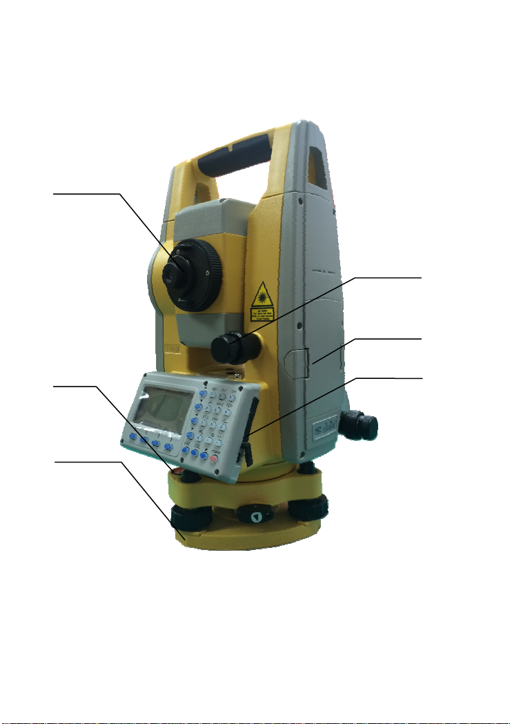
7
VerticalTan
g
entUni
t
DataPor
t
E
y
e
p
iece
Batter
y
CircleVial
Base

8
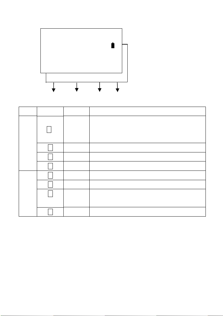
1.2 FUNCTIONS OF KEYS AND INFORMATION DISPLAYED
KEYS:
KeyNameFunction
ANG AnglemeasuringEntertoanglemeasurementmode(:UP.movethe
cursorupwardorselectupperitems)
DISTDistancemeasuringEntertodistancemeasurementmode(:Down.move
thecursordownwardorselectloweritems)
CORDCoordinateMeasuringEntertocoordinatemeasurementmode(:Left.
movethecursorleftward)
MENUMenuEntertomenumode(:Right.movethecursor
rightward)
ENT
EnterConfirmthedataenteredorsavethedataintheitem
andgodowntonextitem
ESC EscapeCancellastoperation,returntolastdisplay,orlastmode.
POWER
PowerShiftthepowerON/OFF
F1-F4 ESC
Star Key
ENT
Power Switch
Numeric Keyboard
Angle
(shift up)
Dist
(shift down)
MENU
(shift right)
Coordinate
(shift left)

9
F1~F4SoftKeysFunctionscorrespondingtoinformationdisplayed.
0~9NumberKeysInputnumbersorcharactersorselectitemsofthe
menu.
∙~‐ SymbolKeysInputsymbols,decimalpoint,±signs.
StarKeyApplicableforsomecertaincommonfunctions.
SymbolsDisplayed:
SymbolDisplayedMeaning
V%verticalangle(slope)
HRhorizontalangle(right)
HLhorizontalangle(left)
HDhorizontaldistance
VDverticaldistance
SDslopdistance
NcoordinateN
EcoordinateE
ZcoordinateZ
*EDM(electronicdistancemeter)isunderoperation.
mmeterastheunit
ftfootastheunit
fifootandinchastheunit

10
1.3 FUNCTIONAL KEYS
ANGLEMEASUREMENTMODE(3interfacemenus)
V:90°10′20″
HR:122°09′30″
ALL0SETHSETP1↓
HOLDREP.V%P2↓
H‐BZR/LCMPSP3↓
[F1][F2][F3][F4]
PageSoftKeyDisplayFunction
Page1
(P1)
F1ALL
Startanglemeasurement,andsavetheresultsinrespectivejob.
(MeasurementfilesandcoordinatesfilesareselectedinDATA
COLLECTmenu.)
F20SETSethorizontalangleto0degree.
F3HSETInputahorizontalanglebykeyboard.
F4 P1↓ DisplaythesoftkeyfunctionsinPage2.
Page2
(P2)
F1HOLDLockthereadingofhorizontalangle.
F2REP.Repeatmeasuringonhorizontalangle.
F3V%Shiftbetweenverticalangle/slopepercentage.
F4 P2↓ DisplaythesoftkeyfunctionsonPage3.
Page3
(P3)
F1H‐BZSetON/OFFforthebeepwhenthehorizontalanglereaches0°,
90°,180°,270°.
F2R/LShiftbetweenright/leftangleofhorizontalangle.
F3CMPSShiftthedisplayformatofverticalangle(verticalangle/azimuth
angle).
F4 P3↓ DisplaythesoftkeyfunctionsonPage1.
11
DISTANCEMEASUREMENTMODE(2interfacemenus)
V:90°10′20″
HR:122°09′30″
SD*[F.S]<<
HD:
VD:
ALLMEASMODEP↓
OFSETS.Om/f/iP2
[F1][F2][F3][F4]
PageSoftKeyDisplayFunction
Page1
(P1)
F1ALL
Startdistancemeasurement,andsavetheresultsinrespective
job.(Measurementfilesandcoordinatesfilesareselectedin
DATACOLLECTmenu.)
F2MEASStartdistancemeasurement.
F3MODEShiftthedistancemeasurementmodes(F.S/F.N/F.R/T.R).
F4 P1↓ DisplaythesoftkeyfunctionsinPage2.
Page2
(P2)
F1OFSETOffsetmeasurementmode.
F2S.ODistancestakeoutmode.
F3m/f/iSetdistanceunit
(meter/feet/feet.inch).
F4 P2↓ DisplaythesoftkeyfunctionsinPage1.
12
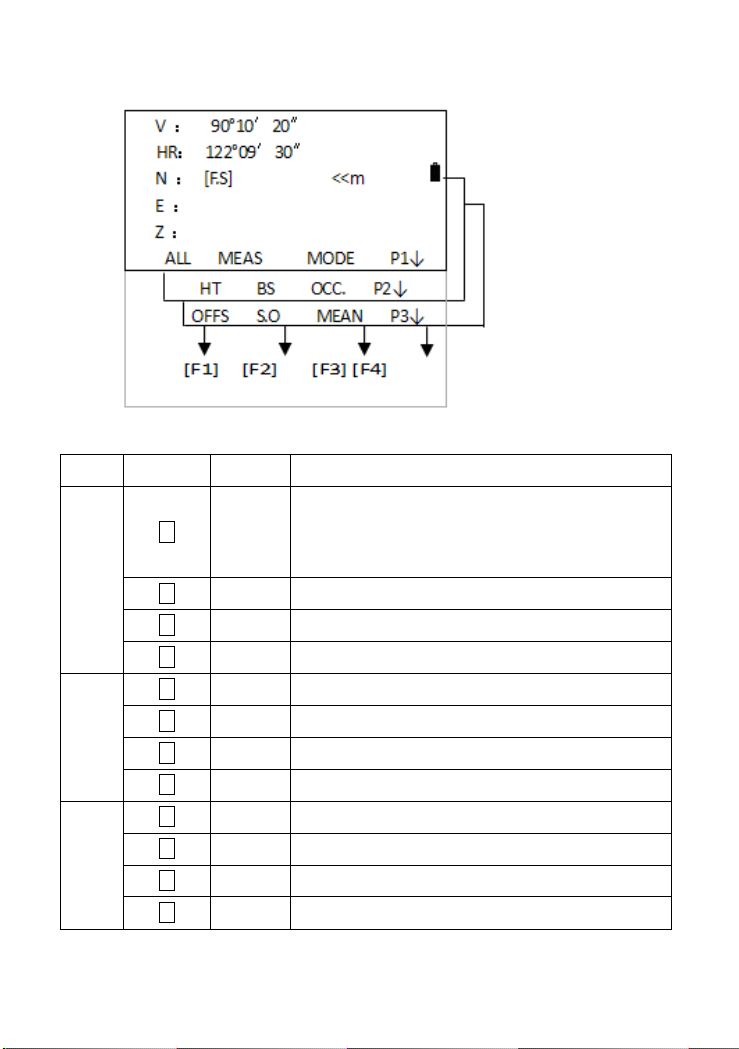
COORDINATESMEASUREMENTMODE(3interfacemenus)
PageSoftKeyDisplayFunction
Page1
(P1)
F1ALL
Startcoordinatesmeasurement,andsavetheresultsin
respectivejob.(Measurementfilesandcoordinatesfilesare
selectedinDATACOLLECTmenu.)
F2MEASStartcoordinatesmeasurement.
F3MODEShiftthedistancemeasurementmodes(F.S/F.N/F.R/T.R).
F4 P1↓ DisplaythesoftkeyfunctionsinPage2.
Page2
(P2)
F1HTSettheinstrumentheightandtargetheight.
F2BSSetthecoordinatesofthebacksightpoint.
F3OCC.Setthecoordinatesoftheoccupiedpoint.
F4 P2↓ DisplaythesoftkeyfunctionsinPage3.
Page3
(P3)
F1OFFSOffsetmeasurementmode.
F2S.OCoordinatesstakeoutmode.
F3MEANSetthemeasuringtimesoffinemeasurement.
F4 P3↓ DisplaythesoftkeyfunctionsinPage1.
Other manuals for N6 Series
1
Table of contents
Other South Measuring Instrument manuals

South
South N9 Series User manual

South
South GALAXY G7 User manual

South
South ET-02 User manual

South
South N3 Series User manual

South
South NTS-960R User manual

South
South Galaxy G1 User manual

South
South N6+ Series User manual

South
South Galaxy G6 User manual

South
South Galaxy G2 User manual

South
South N6 Series User manual


